| Citation: | Dengke Hu, Di Zhou, Xiangjie Wu, Min He, Xiong Pang, Yuwei Wang. Crustal Structure and Extension from Slope to Deepsea Basin in the Northern South China Sea. Journal of Earth Science, 2009, 20(1): 27-37. doi: 10.1007/s12583-009-0003-6

|
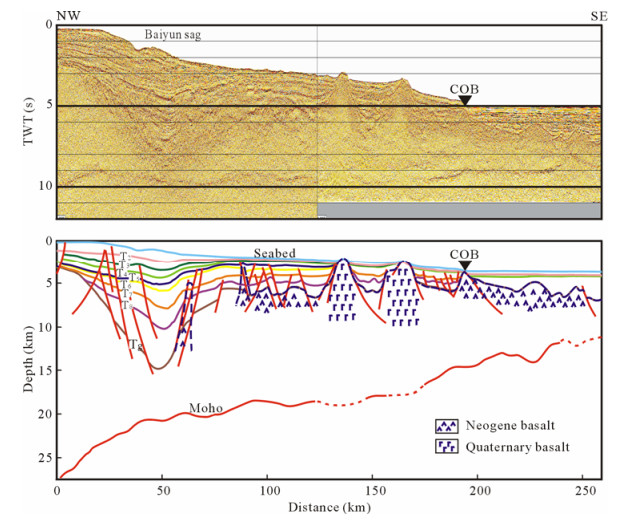
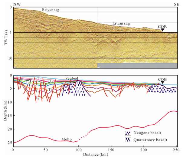
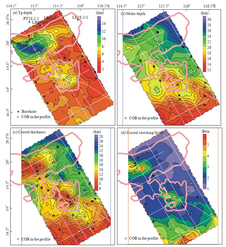
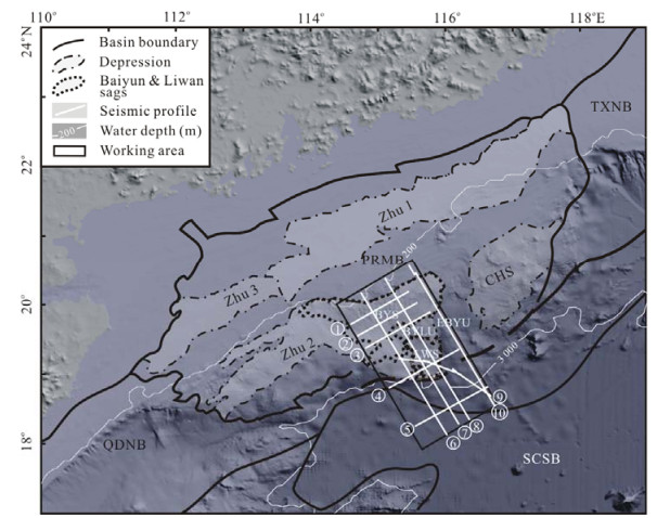
The newly acquired long-cable multi-channel seismic (MCS) lines were used to study the crustal structure and extension in an NW-SE elongated 150 km by 260 km strip from the slope to the deepsea basin in the northern South China Sea (SCS). These profiles are of good penetration that Moho is recognizable in ~70% length of the lines. Seismostratigraphic interpretation and time-depth conversion were conducted. A power function

| Briais, A., Patriat, P., Tapponnier, P., 1993. Updated Interpretation of Magnetic Anomalies and Seafloor Spreading Stages in the South China Sea: Implications for the Tertiary Tectonics of Southeast Asia. J. Geophys. Res., 98(B4): 6299–6328 doi: 10.1029/92JB02280 |
| Cai, X. L., Zhu, J. S., Zhao, L. F., et al., 2001. Three Dimensional Shear Wave Velocity Structure of Crust and Upper Mantle in South China Sea and Its Adjacent Regions by Surface Waveform Inversion. Acta Seismologica Sinica, 14(2): 117–128 doi: 10.1007/s11589-001-0142-z |
| Cande, S. C., Kent, D. V., 1995. Revised Calibration of the Geomagnetic Polarity Timescale for the Late Cretaceous and Cenozoic. J. Geophys. Res., 100(B4): 6093–6095 doi: 10.1029/94JB03098 |
| Clift, P., Lin, J., 2001. Preferential Mantle Lithospheric Extension under the South China Margin. Marine and Petroleum Geology, 18(8): 929–945 doi: 10.1016/S0264-8172(01)00037-X |
| Clift, P., Lin, J., Barckhausen, U., 2002. Evidence of Low Flexural Rigidity and Low Viscosity Lower Continental Crust during Continental Break-up in the South China Sea. Marine and Petroleum Geology, 19(8): 951–970 doi: 10.1016/S0264-8172(02)00108-3 |
| Gong, Z. S., Li, S. T., 1997. Continental Margin Basin Analysis and Hydrocarbon Accumulation of the Northern South China Sea. Science Press, Beijing. 510 (in Chinese) |
| Hu, D. K., Zhou, D., Wu, X. J., et al., 2008. Origin of High Magnetic Anomaly Belt in Northeastern South China Sea as Indicated by Geophysical Inversion. J. Tropical Oceanography, 27(1): 32–37 (in Chinese with English Abstract) http://en.cnki.com.cn/Article_en/CJFDTOTAL-RDHY200801007.htm |
| Huang, C., Zhou, D., Sun, Z., et al., 2005. Deep Crustal Structure of Baiyun Sag, Northern South China Sea Revealed from Deep Seismic Reflection Profile. Chinese Science Bulletin, 50(11): 1131–1138 doi: 10.1360/04wd0207 |
| Jin, W. S., Sun, D. Z., 1997. Deep Crustal Structure and Evolution of South China Continent. Geological Publishing House, Beijing. 175 (in Chinese) |
| Liu, Z., Wang, Q., Su, D., 1983. Contours of Bourguer Gravity Anomalies and Depths of Moho Discontinuity in the South China Sea. J. Tropical Oceanography, 2(2): 167–172 (in Chinese with English Abstract) http://en.cnki.com.cn/Article_en/CJFDTOTAL-RDHY198302013.htm |
| Nissen, S. S., Hayes, D. E., Buhl, P., et al., 1995. Deep Penetration Seismic Soundings across the Northern Margin of the South China Sea. J. Geophys. Res., 100(B11): 22407–22433 doi: 10.1029/95JB01866 |
| Pang, X., Chen, C., Peng, D., et al., 2007. The Pearl River Deep-Water Fan System & Petroleum in South China Sea. Science Press, Beijing. 510 (in Chinese) |
| Qiu, X. L., Ye, S. M., Wu, S., et al., 2001. Crustal Structure across the Xisha Trough, Northwestern South China Sea. Tectonophysics, 341(1–4): 179–193 http://210.77.90.120/bitstream/344004/4688/1/Crustal%20structure%20across%20the%20Xisha%20Trough%2c%20northwestern%20South%20China%20Sea%20.pdf |
| Su, D., Liu, Y., Chen, X., 2004. The 3D Image of the Moho Interface in the South China Sea. In: Zhang, Z., Gao, R., Lü, Q., eds., Deep Structure and Dynamics of the Chinese Continent—To Academician Jiwen Teng for His 50 Anniversary of Geophysical Researches. Science Press, Beijing. 357–365 (in Chinese) |
| Sun, Z., Zhong, Z. H., Zhou, D., et al., 2008. Dynamics Analysis of the Baiyun Sag in the Pearl River Mouth Basin, North of the South China Sea. Acta Geologica Sinica, 82(1): 73–83 doi: 10.1111/j.1755-6724.2008.tb00326.x/abstract |
| Tamaki, K., Honza, E., 1991. Global Tectonics and Formation of Marginal Basins: Role of the Western Pacific. Episodes, 14(3): 224–230 doi: 10.18814/epiiugs/1991/v14i3/005 |
| Wang, W. Y., Dang, W., 2000. Gravity and Magnetic Data Processing in China Offshore and the Adjacent Area. Xi'an College of Engineering & Research Center of China National Offshore Oil Corporation (in Chinese) |
| Yan, P., Zhou, D., Liu, Z. S., 2001. A Crustal Structure Profile across the Northern Continental Margin of the South China Sea. Tectonophysics, 338(1): 1–21 doi: 10.1016/S0040-1951(01)00062-2 |
| Yao, B. C., Zeng, W. J., Chen, Y. Z., et al., 1994. The Crustal Structure in the Eastern Part of the Northern Margin of the South China Sea. Chinese Journal of Geophysics, 37(1): 27–35 (in Chinese with English Abstract |
| Zhou, D., Hu, D. K., He, M., et al., 2008. The Selection of Fitting Curve in Time-Depth Transformation of Deep-Seated Strata. Earth Science—Journal of China University of Geosciences, 33(4): 531–537 (in Chinese with English Abstract) doi: 10.3799/dqkx.2008.067 |
Figures(6)
Copyright © 2013-2020 Journal of Earth Science 鄂ICP备15021562号-2
Tel: +86-27-67885075 Fax: +86-27-67885075 E-mail: xbb@cug.edu.cn
Address: Editorial Office of Journal, China University of Geosciences, Yujiashan, Wuhan, Hubei 430074, P. R. China
Supported by:
Beijing Renhe Information Technology Co. Ltd
E-mail:
info@rhhz.net


 DownLoad: