| Citation: | Baptiste Dafflon, James Irving, Klaus Holliger. Quantitative Integration of High-Resolution Hydrogeophysical Data: A Novel Approach to Monte-Carlo-Type Conditional Stochastic Simulations and Implications for Hydrological Predictions. Journal of Earth Science, 2009, 20(3): 580-591. doi: 10.1007/s12583-009-0048-6

|
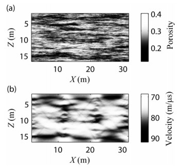
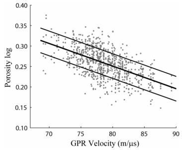
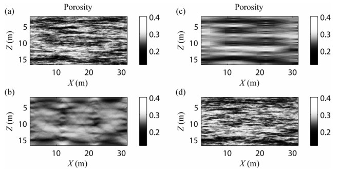
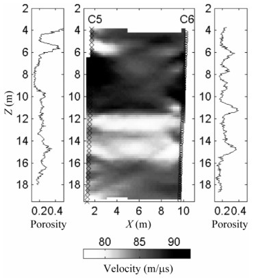
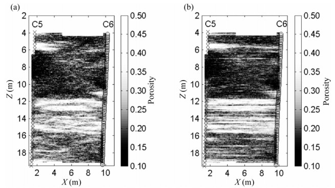
Geophysical techniques can help to bridge the inherent gap that exists with regard to spatial resolution and coverage for classical hydrological methods. This has led to the emergence of a new and rapidly growing research domain generally referred to as hydrogeophysics. Given the differing sensitivities of various geophysical techniques to hydrologically relevant parameters, their inherent trade-off between resolution and range, as well as the notoriously site-specific nature of petrophysical parameter relations, the fundamental usefulness of multi-method surveys for reducing uncertainties in data analysis and interpretation is widely accepted. A major challenge arising from such endeavors is the quantitative integration of the resulting vast and diverse database into a unified model of the probed subsurface region that is consistent with all available measurements. To this end, we present a novel approach toward hydrogeophysical data integration based on a Monte-Carlo-type conditional stochastic simulation method that we consider to be particularly suitable for high-resolution local-scale studies. Monte Carlo techniques are flexible and versatile, allowing for accounting for a wide variety of data and constraints of differing resolution and hardness, and thus have the potential of providing, in a geostatistical sense, realistic models of the pertinent target parameter distributions. Compared to more conventional approaches, such as co-kriging or cluster analysis, our approach provides significant advancements in the way that larger-scale structural information contained in the hydrogeophysical data can be accounted for. After outlining the methodological background of our algorithm, we present the results of its application to the integration of porosity log and tomographic crosshole georadar data to generate stochastic realizations of the detailed local-scale porosity structure. Our procedure is first tested on pertinent synthetic data and then applied to a field dataset collected at the Boise Hydrogeophysical Research Site. Finally, we compare the performance of our data integration approach to that of more conventional methods with regard to the prediction of flow and transport phenomena in highly heterogeneous media and discuss the implications arising.

| Barrash, W., Clemo, T., 2002. Hierarchical Geostatistics and Multifacies Systems: Boise Hydrogeophysical Research Site, Boise, Idaho. Water Resour. Res. , 38: 1196. DOI:10.1029/2002WR001436 |
| Bosch, M., 2004. The Optimization Approach to Lithological Inversion: Combining Seismic Data and Petrophysics for Porosity Prediction. Geophysics, 69: 1272–1282 doi: 10.1190/1.1801944 |
| Cassiani, G., Boehm, G., Vesnaver, A., et al., 1998. A Geostatistical Framework for Incorporating Seismic Tomography Auxiliary Data into Hydraulic Conductivity Estimation. J. Hydrol. , 206: 58–74 doi: 10.1016/S0022-1694(98)00084-5 |
| Chen, J., Hubbard, S., Rubin, Y., 2001. Estimating the Hydraulic Conductivity at the South Oyster Site from Geophysical Tomographic Data Using Bayesian Techniques Based on the Normal Linear Regression Model. Water Resour. Res. , 37: 1603–1613 doi: 10.1029/2000WR900392 |
| Dafflon, B., Irving, J., Holliger, K., 2009. Simulated-Annealing-Based Conditional Simulation for the Local-Scale Characterization of Heterogeneous Aquifers. J. Appl. Geophys. , 68: 60–70 doi: 10.1016/j.jappgeo.2008.09.010 |
| Dannowski, G., Yaramanci, U., 1999. Estimation of Water Content and Porosity Using Combined Radar and Geoelectrical Measurements. Europ. J. Env. Eng. Geophys. , 4: 71–85 doi: 10.4133/JEEG4.1.71 |
| Deutsch, C. V., 2002. Geostatistical Reservoir Modeling. Oxford University Press, Oxford |
| Ernst, J. R., Holliger, K., Maurer, H. R., et al., 2006. Realistic FDTD Modeling of Borehole Georadar Antenna Radiation: Methodology and Application. Near Surface Geophysics, 4: 19–30 doi: 10.3997/1873-0604.2005028 |
| Ernst, J. R., Maurer, H. R., Green, A. G., et al., 2007. Application of a New 2-D Time-Domain Full-Waveform Inversion Scheme to Crosshole Radar Data. Geophysics, 72: J53–J64 doi: 10.1190/1.2761848 |
| Ezzedine, S., Rubin, Y., Chen, J., 1999. Bayesian Method for Hydrogeological Site Characterization Using Borehole and Geophysical Survey Data: Theory and Application to the Lawrence Livermore National Laboratory Superfund Site. Water Resour. Res. , 35(9): 2671–2684 doi: 10.1029/1999WR900131 |
| Gallardo, L. A., Meju, M. A., 2003. Characterization of Heterogeneous Near-Surface Materials by Joint 2D Inversion of Resistivity and Seismic Data. Geophys. Res. Lett., DOI:10.1029/2003GL017370 |
| Garambois, S., Sénéchal, P., Perroud, H., 2002. On the Use of Combined Geophysical Methods to Assess Water Content and Water Conductivity of Near-Surface Formations. J. Hydrol. , 259: 32–48 doi: 10.1016/S0022-1694(01)00588-1 |
| Gelhar, L. W., 1993. Stochastic Subsurface Hydrology. Prentice-Hall, Englewood Cliffs |
| Gelman, A., Carlin, J. B., Stern, H. S., et al., 2003. Bayesian Data Analysis. 2nd ed. . Chapman & Hall, Boca Raton |
| Gloaguen, E., Chouteau, M., Marcotte, D., et al., 2001. Estimation of Hydraulic Conductivity of an Unconfined Aquifer Using Cokriging of GPR and Hydrostratigraphic Data. J. Appl. Geophys. , 47: 135–152 doi: 10.1016/S0926-9851(01)00057-X |
| Hoeppner, F., Klawonn, F., Kruse, R., et al., 1999. Fuzzy Cluster Analysis: Methods for Classification, Data Analysis and Image Recognition. Wiley, Chichester |
| Hubbard, S. S., Rubin, Y., 2005. Introduction to Hydrogeophysics. In: Rubin, Y., Hubbard, S. S., eds., Hydrogeophysics. Springer, Dordrecht. 3–21 |
| Hubbard, S. S., Chen, J., Peterson, J., et al., 2001. Hydrogeological Characterization of the South Oyster Bacterial Transport Site Using Geophysical Data. Water Resour. Res. , 37: 2431–2456 doi: 10.1029/2001WR000279 |
| Hyndman, D. W., Harris, J. M., 1996. Traveltime Inversion for the Geometry of Aquifer Lithologies. Geophysics, 61: 1728–1737 doi: 10.1190/1.1444090 |
| Hyndman, D. W., Harris, J. M., Gorelick, S. M., 2000. Inferring the Relation between Seismic Slowness and Hydraulic Conductivity in Heterogeneous Aquifers. Water Resour. Res. , 36: 2121–2132 doi: 10.1029/2000WR900112 |
| Kaufman, L., Rousseeuw, P. J., 1990. Finding Groups in Data: An Introduction to Cluster Analysis. Wiley, New York |
| Kelkar, M., Perez, G., 2002. Applied Geostatistics for Reservoir Characterization. Society of Petroleum Engineers |
| Kirsch, R., 2006. Groundwater Geophysics. Springer, Berlin |
| Kowalsky, M., Finsterle, S., Peterson, et al., 2005. Estimation of Field-Scale Soil Hydraulic and Dielectric Parameters through Joint Inversion of GPR and Hydrological Data. Water Resour. Res. , 41: W11425. DOI:10.1029/2005WR004237 |
| Linde, N., Finsterle, S., Hubbard, S., 2006. Inversion of Tracer Test Data Using Tomographic Constraints. Water Resour. Res. , 42: W04410. DOI: 10.1029/2004WR003806 |
| Linde, N., Tryggvason, A., Peterson, J. E., et al., 2008. Joint Inversion of Crosshole Radar and Seismic Traveltimes Acquired at the South Oyster Bacterial Transport Site. Geophysics, 73(4): G29–G37 doi: 10.1190/1.2937467 |
| Paasche, H., Tronicke, J., Holliger, K., et al., 2006. Integration of Diverse Physical-Property Models: Subsurface Zonation and Petrophysical Parameter Estimation Based on Fuzzy C-Means Cluster Analyses. Geophysics, 71: H33–H44 doi: 10.1190/1.2192927 |
| Rubin, Y., Hubbard, S. S., 2005a. Hydrogeophysics. Springer, Dordrecht |
| Rubin, Y., Hubbard, S. S., 2005b. Stochastic Forward and Inverse Modelling: The "Hydrogeophysical" Challenge. In: Rubin, Y., Hubbard, S. S., eds., Hydrogeophysics. Springer, Dordrecht. 487–511 |
| Schoen, J. H., 1996. Physical Properties of Rocks: Fundamentals and Principles of Petrophysics. Pergamon, Oxford |
| Sen, M., Stoffa, P. L., 1995. Global Optimization Methods in Geophysical Inversion. Elsevier, Amsterdam |
| Szerbiak, R. B., McMechan, G. A., Corbeanu, R. M., et al., 2001. 3-D Characterization of a Clastic Reservoir Analog: From 3-D GPR Data to a 3-D Fluid Permeability Model. Geophysics, 66: 1026–1037 doi: 10.1190/1.1487050 |
| Tronicke, J., Holliger, K., Barrash, W., et al., 2004. Multivariate Analysis of Cross-Hole Georadar Velocity and Attenuation Tomograms for Aquifer Zonation. Water Resour. Res., DOI:10.1029/2003WR002031 |
| Tronicke, J., Holliger, K., 2005. Quantitative Integration of Hydrogeophysical Data: Conditional Geostatistical Simulation for Characterizing Heterogeneous Alluvial Aquifers. Geophysics, 70: H1–H10 doi: 10.1190/1.1925744 |
| Vereecken, H., Binley, A., Cassiani, G., et al., 2006. Applied Hydrogeophysics. Springer, Dordrecht |
Figures(8)
Copyright © 2013-2020 Journal of Earth Science 鄂ICP备15021562号-2
Tel: +86-27-67885075 Fax: +86-27-67885075 E-mail: xbb@cug.edu.cn
Address: Editorial Office of Journal, China University of Geosciences, Yujiashan, Wuhan, Hubei 430074, P. R. China
Supported by:
Beijing Renhe Information Technology Co. Ltd
E-mail:
info@rhhz.net


 DownLoad: