Advanced Search

Indexed by SCI、CA、РЖ、PA、CSA、ZR、etc .

2018 Vol. 29, No. 6

CONTENTS
CONTENTS
2018, 29(6): .
Abstract:
Invited Review
Geological Evidence for the Operation of Plate Tectonics throughout the Archean: Records from Archean Paleo-Plate Boundaries
Timothy M. Kusky, Brian F. Windley, Ali Polat
2018, 29(6): 1291-1303. doi: 10.1007/s12583-018-0999-6
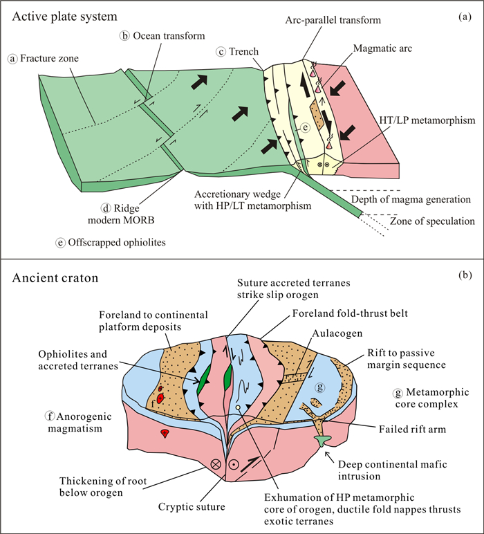
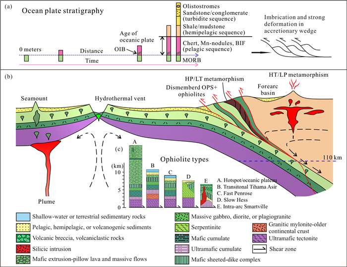
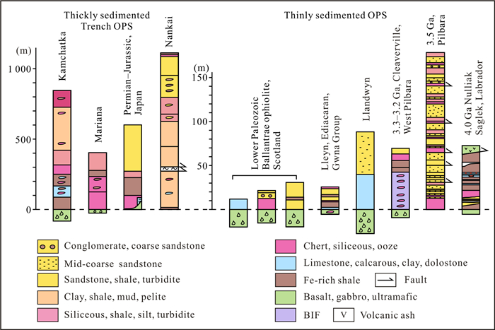
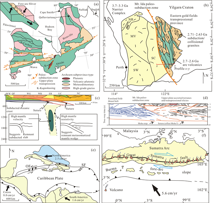
Abstract:
Plate tectonics describes the horizontal motion of rigid lithospheric plates away from mid-oceanic ridges and parallel to transforms, towards deep-sea trenches, where the oceanic lithosphere is subducted into the mantle. This process is the surface expression of modern-day heat loss from Earth. One of the biggest questions in Geosciences today is "when did plate tectonics begin on Earth" with a wide range of theories based on an equally diverse set of constraints from geology, geochemistry, numerical modeling, or pure speculation. In this contribution, we turn the coin over and ask "when was the last appearance in the geological record for which there is proof that plate tectonics did not operate on the planet as it does today". We apply the laws of uniformitarianism to the rock record to ask how far back in time is the geologic record consistent with presently-operating kinematics of plate motion, before which some other mechanisms of planetary heat loss may have been in operation. Some have suggested that evidence shows that there was no plate tectonics before 800 Ma ago, others sometime before 1.8-2.7 Ga, or before 2.7 Ga. Still others recognize evidence for plate tectonics as early as 3.0 Ga, 3.3-3.5 Ga, the age of the oldest rocks, or in the Hadean before 4.3 Ga. A key undiscussed question is:why is there such a diversity of opinion about the age at which plate tectonics can be shown to not have operated, and what criteria are the different research groups using to define plate tectonics, and to recognize evidence of plate tectonics in very old rocks? Here, we present and evaluate data from the rock record, constrained by relevant geochemical-isotopic data, and conclude that the evidence shows indubitably that plate tectonics has been operating at least since the formation of the oldest rocks, albeit with some differences in processes, compositions, and products in earlier times of higher heat generation and mantle temperature, weaker oceanic lithosphere, hotter subduction zones caused by more slab-melt generation, and under different biological and atmospheric conditions.
Geophysical Imaging from Subduction Zones to Petroleum Reservoirs
Proto-South China Sea Plate Tectonics Using Subducted Slab Constraints from Tomography
Jonny Wu, John Suppe
2018, 29(6): 1304-1318. doi: 10.1007/s12583-017-0813-x
Abstract:
The past size and location of the hypothesized proto-South China Sea vanished ocean basin has important plate-tectonic implications for Southeast Asia since the Mesozoic. Here we present new details on proto-South China Sea paleogeography using mapped and unfolded slabs from tomogra-phy. Mapped slabs included:the Eurasia-South China Sea slab subducting at the Manila trench; the northern Philippine Sea Plate slab subducting at the Ryukyu trench; and, a swath of detached, sub-horizontal, slab-like tomographic anomalies directly under the South China Sea at 450 to 700 km depths that we show is subducted 'northern proto-South China Sea' lithosphere. Slab unfolding revealed that the South China Sea lay directly above the 'northern Proto-South China Sea' with both extending 400 to 500 km to the east of the present Manila trench prior to subduction. Our slab-based plate reconstruction indicated the proto-South China Sea was consumed by double-sided subduction, as follows:(1) The 'northern proto-South China Sea' subducted in the Oligo-Miocene under the Dangerous Grounds and southward expanding South China Sea by in-place 'self subduction' similar to the western Mediterranean basins; (2) limited southward subduction of the proto-South China Sea under Borneo occurred pre-Oligocene, represented by the 800-900 km deep 'southern proto-South China Sea' slab.
Development and Evolution of the Size of Polygonal Fracture Systems during Fluid-Solid Separation in Clay-Rich Deposits
Teodolina Lopez, Raphaël Antoine, José Darrozes, Michel Rabinowicz, David Baratoux
2018, 29(6): 1319-1334. doi: 10.1007/s12583-017-0814-9
Abstract:
In continental and oceanic conditions, clay-rich deposits are characterised by the development of polygonal fracture systems (PFS). PFS can increase the vertical permeability of clay-rich deposits (mean permeability ≤ 10-16 m2) and are pathways for fluids. On continents, the width of PFS ranges from centimeters to hundreds of meters, while in oceanic contexts they are up to a few kilometers large. These structures are linked to water-solid separation during deposition, consolidation and complete fluid squeeze of the clay horizon. During the last few decades, modeling of melt migration in partially molten plastic rocks led to rigorous quantifications of two-phase flows with a particular emphasis on 2D and 3D induced flow structures. The numerical modeling shows that the melt migrates on distances almost equal to a few times the compaction length L that depends on permeability and viscosity. Consequently, polygonal structures in partially molten plastic rocks are resulted from the melt-rock separation and their sizes are proportional to L. Applying these results to fluid-solid separation in clay-rich horizons, we show that (1) centimetric to kilometric PFS are resulted from the dramatic increase of L during compaction and (2), this process involves agglomerates with 100 μm to 1 mm size.
On the Fluid Dependence of Seismic Anisotropy: Beyond Biot-Gassmann
Leon Thomsen
2018, 29(6): 1335-1339. doi: 10.1007/s12583-017-0806-9
Abstract:
This work addresses the question of the fluid dependence of the non-dimensional parameters of seismic anisotropy. It extends the classic theory of the fluid-dependence of elasticity, and applies the approximation of weak seismic anisotropy. The analysis shows that reliance upon the classic theory leads to oversimplified conclusions. Extending the classic theory introduces new parameters (which must be experimentally determined) into the conclusions, making their application in the field context highly problematic.
Insight into Urban Faults by Wavelet Multi-Scale Analysis and Modeling of Gravity Data in Shenzhen, China
Chuang Xu, Haihong Wang, Zhicai Luo, Hualiang Liu, Xiangdong Liu
2018, 29(6): 1340-1348. doi: 10.1007/s12583-017-0770-4
Abstract:
Urban faults in Shenzhen are potential threats to city security and sustainable development. In consideration of the importance of the Shenzhen fault zone, the author provide a detailed interpretation on gravity data model. Bouguer gravity covering the whole Shenzhen City was calculated with a 1-km resolution. Wavelet multi-scale analysis (MSA) was applied to the Bouguer gravity data to obtain the multilayer residual anomalies corresponding to different depths. In addition, 2D gravity models were constructed along three profiles. The Bouguer gravity anomaly shows an NE-striking high-low-high pattern from northwest to southeast, strongly related to the main faults. According to the results of MSA, the correlation between gravity anomaly and faults is particularly significant from 4 to 12 km depth. The residual gravity with small amplitude in each layer indicates weak tectonic activity in the crust. In the upper layers, positive anomalies along most of faults reveal the upwelling of high-density materials during the past tectonic movements. The multilayer residual anomalies also yield important information about the faults, such as the vertical extension and the dip direction. The maximum depth of the faults is about 20 km. In general, NE-striking faults extend deeper than NW-striking faults and have a larger dip angle.
Investigation of the Tikhonov Regularization Method in Regional Gravity Field Modeling by Poisson Wavelets Radial Basis Functions
Yihao Wu, Bo Zhong, Zhicai Luo
2018, 29(6): 1349-1358. doi: 10.1007/s12583-017-0771-3
Abstract:
The application of Tikhonov regularization method dealing with the ill-conditioned problems in the regional gravity field modeling by Poisson wavelets is studied. In particular, the choices of the regularization matrices as well as the approaches for estimating the regularization parameters are inves-tigated in details. The numerical results show that the regularized solutions derived from the first-order regularization are better than the ones obtained from zero-order regularization. For cross validation, the optimal regularization parameters are estimated from L-curve, variance component estimation (VCE) and minimum standard deviation (MSTD) approach, respectively, and the results show that the derived regularization parameters from different methods are consistent with each other. Together with the first-order Tikhonov regularization and VCE method, the optimal network of Poisson wavelets is derived, based on which the local gravimetric geoid is computed. The accuracy of the corresponding gravimetric geoid reaches 1.1 cm in Netherlands, which validates the reliability of using Tikhonov regularization method in tackling the ill-conditioned problem for regional gravity field modeling.
Prestack Multi-Gather Simultaneous Inversion of Elastic Parameters Using Multiple Regularization Constraints
Shu Li, Zhenming Peng, Hao Wu
2018, 29(6): 1359-1371. doi: 10.1007/s12583-017-0905-7
Abstract:
Inversion of Young's modulus, Poisson's ratio and density from pre-stack seismic data has been proved to be feasible and effective. However, the existing methods do not take full advantage of the prior information. Without considering the lateral continuity of the inversion results, these methods need to invert the reflectivity first. In this paper, we propose multi-gather simultaneous inversion for pre-stack seismic data. Meanwhile, the total variation (TV) regularization, L1 norm regularization and initial model constraint are used. In order to solve the objective function contains L1 norm, TV norm and L2 norm, we develop an algorithm based on split Bregman iteration. The main advantages of our method are as follows:(1) The elastic parameters are calculated directly from objective function rather than from their reflectivity, therefore the stability and accuracy of the inversion process can be ensured. (2) The inversion results are more in accordance with the prior geological information. (3) The lateral continuity of the inversion results are improved. The proposed method is illustrated by theoretical model data and experimented with a 2-D field data.
Seismic Attribute Analysis with Saliency Detection in Fractional Fourier Transform Domain
Yuqing Wang, Zhenming Peng, Yan Han, Yanmin He
2018, 29(6): 1372-1379. doi: 10.1007/s12583-017-0811-z
Abstract:
Most image saliency detection models are dependent on prior knowledge and demand high computational cost. However, spectral residual (SR) and phase spectrum of the Fourier transform (PFT) models are simple and fast saliency detection approaches based on two-dimensional Fourier transform without the prior knowledge. For seismic data, the geological structure of the underground rock for-mation changes more obviously in the time direction. Therefore, one-dimensional Fourier transform is more suitable for seismic saliency detection. Fractional Fourier transform (FrFT) is an improved algo-rithm for Fourier transform, therefore we propose the seismic SR and PFT models in one-dimensional FrFT domain to obtain more detailed saliency maps. These two models use the amplitude and phase in-formation in FrFT domain to construct the corresponding saliency maps in spatial domain. By means of these two models, several saliency maps at different fractional orders can be obtained for seismic attribute analysis. These saliency maps can characterize the detailed features and highlight the object areas, which is more conducive to determine the location of reservoirs. The performance of the proposed method is assessed on both simulated and real seismic data. The results indicate that our method is effective and convenient for seismic attribute extraction with good noise immunity.
Impact and Solutions of Seawater Heterogeneity on Wide-Angle Tomographic Inversion of Crustal Velocities in Deep Marine Environments-Numerical Studies
Zhihui Zou, Hua-Wei Zhou, Harold Gurrola, Aifei Bian, Zhonglai Huang, Jianzhong Zhang
2018, 29(6): 1380-1389. doi: 10.1007/s12583-017-0816-7
Abstract:
The seawater column is typically taken as a homogeneous velocity layer in wide-angle crustal seismic surveys in marine environments. However, heterogeneities in salinity and temperature throughout the seawater layer result insignificant lateral variations in its seismic velocity, especially in deep marine environments. Failure to compensate for these velocity inhomogeneities will introduce significant artifacts in constructing crustal velocity models using seismic tomography. In this study, we conduct numerical experiments to investigate the impact of heterogeneous seismic velocities in seawater on tomographic inversion for crustal velocity models. Experiments that include lateral variation in seawater velocity demonstrated that the modeled crustal velocities were contaminated by artifacts from tomographic inversions when assuming a homogeneous water layer. To suppress such artifacts, we propose two strategies:(1) simultaneous inversion of water velocities and the crustal velocities; (2) lay-er-stripping inversion during which to first invert for seawater velocity and then correct the travel times before inverting for crustal velocities. The layer-stripping inversion significantly improves the modeling of variation in seawater velocity when preformed with seismic sensors deployed on the ocean bottom and in the water column. Such strategies improve crustal modeling via wide-angle seismic surveys in deep-marine environment.
AVA Simultaneous Inversion of Prestack Seismic Data Using Particle Swarm Optimization
Jin Zhang, Peng Shen, Weina Zhao, Xubing Guo, Wang Xing, Song Chen, Xiugang Xu
2018, 29(6): 1390-1397. doi: 10.1007/s12583-017-0809-6
Abstract:
A new prestack AVA simultaneous inversion using particle swarm optimization algorithm is proposed, which can obtain the elastic parameters such as P-wave and S-wave impedance from P-wave reflection data simultaneously. Compared with the conventional AVA inversion based on generalized linear technique, this method does not depend on the initial model and can reach the global minimum. In order to increase the stability of the inversion, low-frequency trends of P-wave and S-wave impedances are built into the inversion. This method has been successfully applied to synthetic and field data. The estimated P-wave and S-wave impedances can be combined to derive other elastic parameters, which are sensitive for lithology identification and fluid prediction.
Observations of the Singlets of Higher-Degree Modes Based on the OSE
Shi-Yu Zeng, Wen-Bin Shen
2018, 29(6): 1398-1408. doi: 10.1007/s12583-017-0810-0
Abstract:
In this study, we selected 18 SG (superconducting gravimeter) records from 15 GGP stations with 99 vertical and 69 horizontal components of IRIS broad-band seismograms during 2004 Sumatra Earthquake to detect the splitting of higher-degree Earth's free oscillations modes (0S4, 0S7~0S10, 2S4, 1S5, 2S5, 1S6) and 12 inner-core sensitive modes (25S2, 27S2, 6S3, 9S3, 13S3, 15S3, 11S4, 18S4, 8S5, 11S5, 23S5, 16S6) by using OSE (optimal sequence estimation) method which only considers self-coupling. Results indicate that OSE can completely isolate singlets of high-degree modes in time-domain, effectively resolve the coupled multiplets independently, and reduce the possibility of mode mixing and end effect, showing that OSE could improve some signals' signal-to-noise ratio. Comparing the results of SG records with seismic data sets suggests that the number of SG records is inadequate to detect all singlets of higher modes. Hence we mainly selected plentiful seismograms of IRIS to observe the multiplets of higher modes. We estimate frequencies of the singlets using AR method and evaluate the measurement error using bootstrap method. Besides, we compared the observa-tions with the predictions of PREM-tidal model. This study demonstrates that OSE is effective in isolating singlets of Earth's free oscillations with higher modes. The experimental results may provide constraints to the construction of 3D Earth model.
Distribution of Intra-Crustal Low Velocity Zones beneath Yunnan from Seismic Ambient Noise Tomography
Weibing Qin, Shuangxi Zhang, Mengkui Li, Tengfei Wu, Chaoyu Zhang
2018, 29(6): 1409-1418. doi: 10.1007/s12583-017-0815-8
Abstract:
Previous studies have reached consensus that low velocity zones are widespread in the crust beneath Yunnan region. However, the relationships between the low velocity zones and large faults, earthquake distribution are less investigated by available studies. By analyzing the seismic ambient noise recorded by Yunnan Seismic Networks and Tengchong volcano array, we construct a 3D crustal shear wave velocity model for the Yunnan region, which provides more details of the distribution of intra-crustal low velocity zones all over Yunnan. The distribution of low velocity zones shows different features at different depths. At shallow depths, the results are well correlated with near surface geological features. With increasing depth, the low velocity zones are gradually concentrated on the northern part of our study area, most likely reflecting variations in crustal thickness beneath the Yunnan region. The low velocity zones are truncated at depth by several large faults in Yunnan. It is interesting that most strong earthquakes (Ms ≥ 5.0) occurred in Yunnan are distributed in low velocity zones or the transition zones between low and high velocity anomalies within the upper-to-middle crust. The crustal structure is composed of a brittle, seismically active upper-to-middle crust and a warm, aseismic lower crust.
Crustal Structure of Yunnan Province of China from Teleseismic Receiver Functions: Implications for Regional Crust Evolution
Fang Wang, Shuangxi Zhang, Mengkui Li
2018, 29(6): 1419-1430. doi: 10.1007/s12583-017-0822-9
Abstract:
Yunnan Province is located on the southeastern margin of Tibet and represents an important marker in understanding the tectonic evolution of Tibetan Plateau. In this study, we calculated teleseismic P-wave receiver functions at 49 permanent broadband seismic stations in Yunnan Province and estimated crustal thickness and the bulk crust ratios of P-wave to S-wave velocities using the H-κ method together with more detailed crustal structural profiles from the common conversion point stacking method. There is a significant transition of Moho interface and lower crustal composition along latitude 26°N in northwestern Yunnan. Decrease of crustal thickness with a concomitant increase of Poisson's ratio occurs at station CUX. An interesting phenomenon is that a step-like Moho fashion is observed at several stations, which might correspond to local thermal activities, such as partial melt/lower crust delamination. Our results show changes in crustal properties appear to be associated with varieties in upper mantle structure and compositions. We propose the controlling factor of the dynamic processes below 26°N is the result of eastern forward subduction of the Indian Plate; the northern part is controlled by the redirected material flow from the SE Tibet.
Volcanology
Paleoproterozoic Underwater Volcanism and Microfossil-Like Structures in the Metasedimentary Siliceous Rocks, Hogland Island, Russia
Anatoly M. Belyaev
2018, 29(6): 1431-1442. doi: 10.1007/s12583-018-0883-4
Abstract:
Geological surveys showed that rhyolite and basalt strata with pillow structures typical for underwater volcanism form sheets over the Svecofennian basement. Original geochemical and isotope-geochemical data confirmed that the rhyolites were formed contemporaneously with the ra-pakivi granites of the Wiborg Massif (1 640 Ma), and the basalts are similar to gabbro-anorthosites. Abnormally high content of K2O and relatively low content of Na2O in rhyolites and basalts are interpreted as a result of hydrothermal interaction of eruptive magmas with K-enriched hot seawater. The strata of siliceous metasedimentary rocks (microquartzites) within basaltic and rhyolitic lavas were formed in processes of chemogenic sedimentation and subsequent contact metamorphism during underwater volcanism. Microquartzites showed carbon vastly depleted of heavy isotope 13C. This is typical for rocks formed with participation of living substance. The Raman spectra of the remaining carbon-containing substance have graphite bands. In the microquartzites among basalts and rhyolites we found a community of structures with external and internal morphology similar to modern or fossilized marine microorganisms:spiral cyanobacterias, amoebas, diatoms, foraminifers, virus capsids, flagellates and multicellular organisms. It is assumed that these silificated and ferruginizated microfossils represent the Paleoproterozoic community of marine microorganisms.