Advanced Search

Indexed by SCI、CA、РЖ、PA、CSA、ZR、etc .

2022 Vol. 33, No. 4

COVER
2022, 33(4)
Abstract:
CONTENTS
2022, 33(4)
Abstract:
Special Column on the 2021 Yunnan Mw 6.1 and Qinghai Mw 7.3 Earthquakes
Guest Editors: Qi Wang, Dun Wang and Wenkai Chen
Estimating Seismic Intensity Maps of the 2021 Mw 7.3 Madoi, Qinghai and Mw 6.1 Yangbi, Yunnan, China Earthquakes
Wenkai Chen, Dun Wang, Can Zhang, Qiang Yao, Hongjun Si
2022, 33(4): 839-846. doi: 10.1007/s12583-021-1586-9
Abstract:

This study focuses on rapidly determining seismic intensity maps of earthquakes because it offers fundamental information for effective emergency rescue and subsequent scientific research, and remains challenging to accurately determine seismic intensity map in regions with sparse instrumental observations. Here we applied a novel method that consisted of array technology (back-projection), ground-motion prediction equations, and site corrections, to estimate the seismic intensity maps of the 2021 Mw 7.3 Madoi, Qinghai and the Mw 6.1 Yangbi, Yunnan, China earthquakes. We used seismic data recorded at European stations to back-project the source processes of the 2021 Mw 7.3 Madoi, Qinghai and the Mw 6.1 Yangbi, Yunnan, China earthquakes. The back-projected energy radiations were then used as subevents or used to define the fault geometry. Summing the contributions of each subevent or estimating the shortest distances from each site to the rupture fault, we obtained the ground motion (PGA and PGV) for each site under rock site conditions. The estimated ground motions were corrected at each site for local site amplification according to the Vs30 database.Our estimated seismic intensity maps and field reports showed high similarity, which further validated the effectiveness of the novel approach, and pushed the limit of earthquake size down to ~M 6. Such efforts would substantially help in the fast and accurate evaluation of earthquake damage, and precise rescue efforts.

Determination and Comparison of ML, MS_BB, mB, MWp, MWW, Mdt, and M (GNSS) for the 22 May 2021 M7.4 Madoi, Qianghai, China Earthquake
Xiaolin Huang, Yuyang Peng, Chuang Cheng, Dun Wang, Qiang Yao
2022, 33(4): 847-856. doi: 10.1007/s12583-022-1680-7
Abstract:

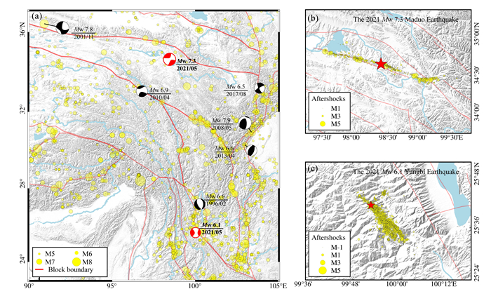
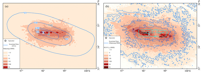
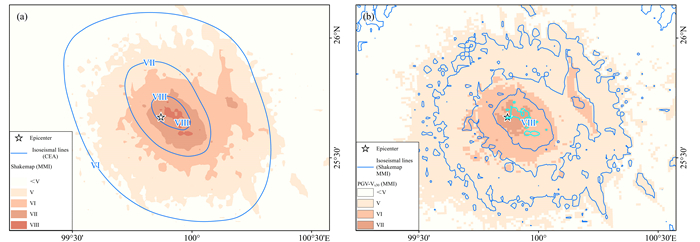
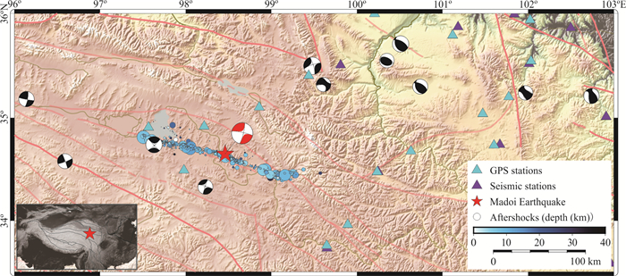
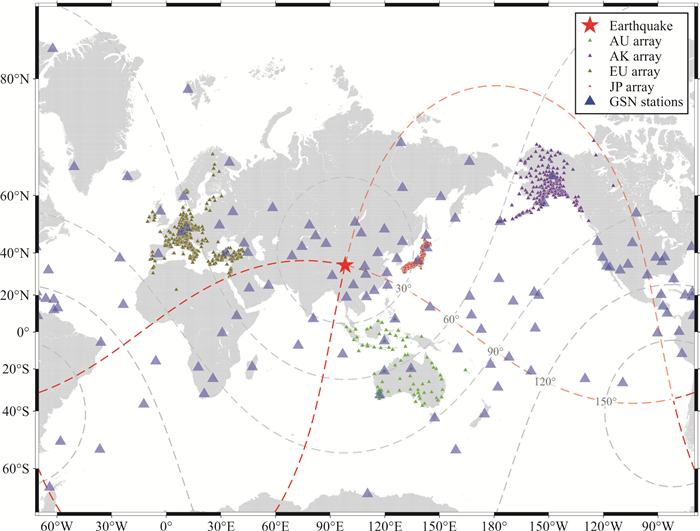
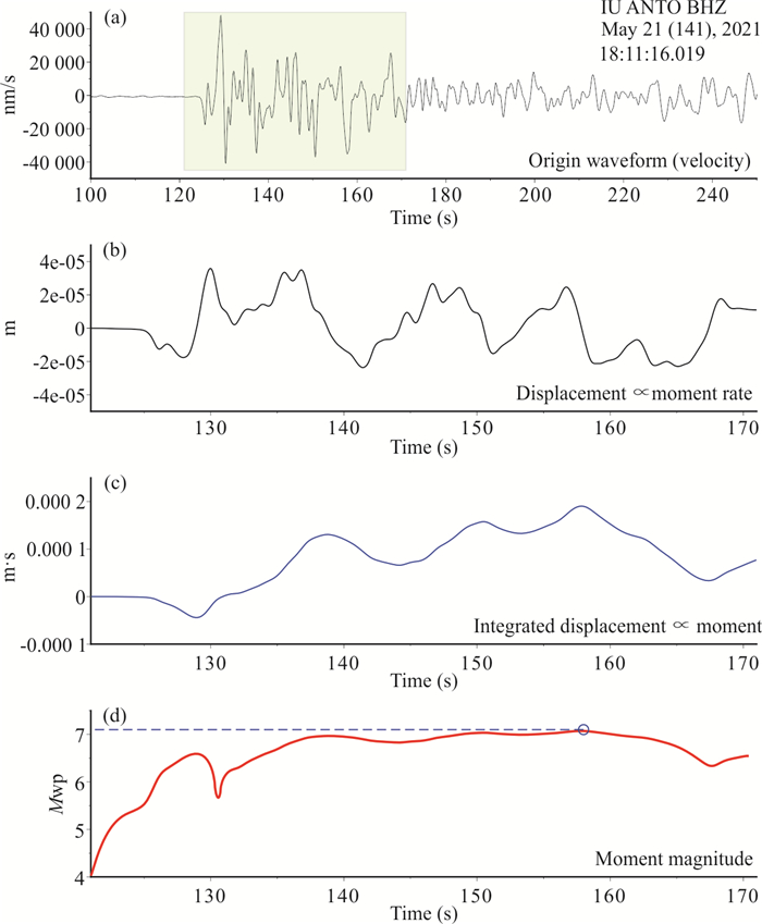
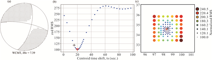
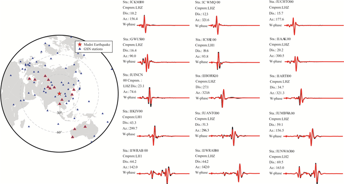
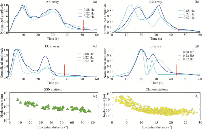
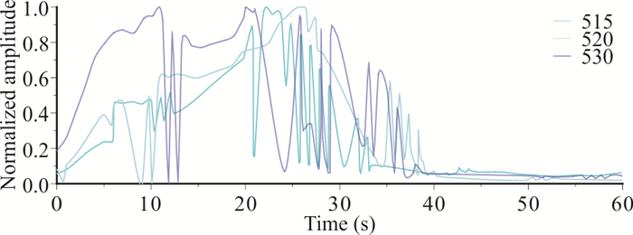
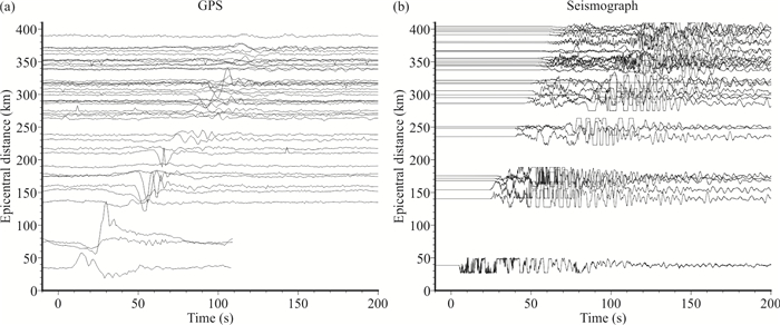
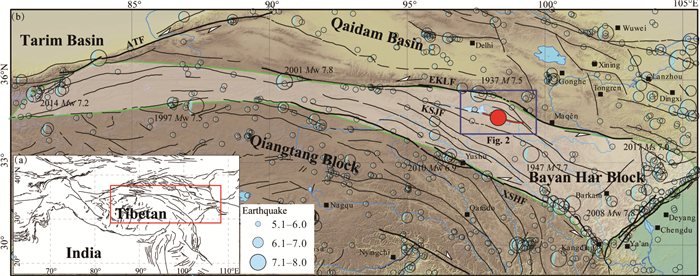
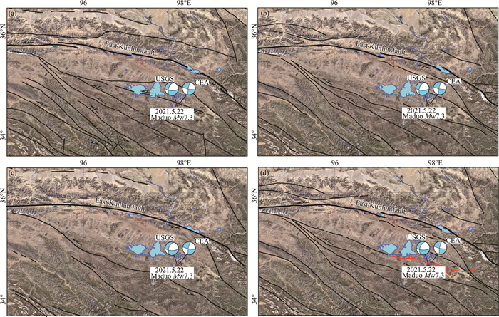
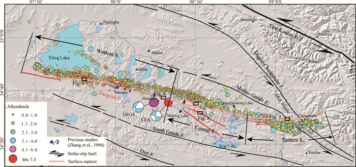
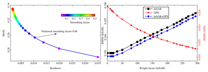
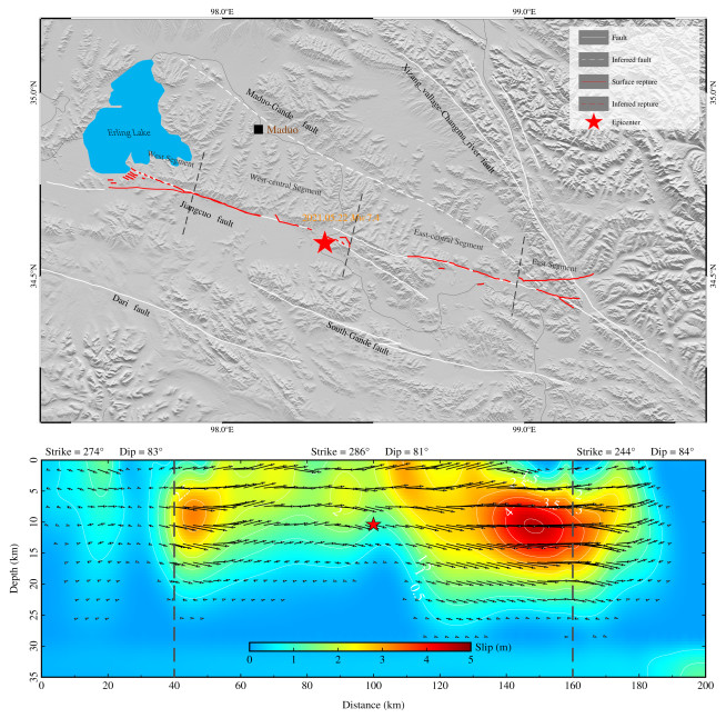
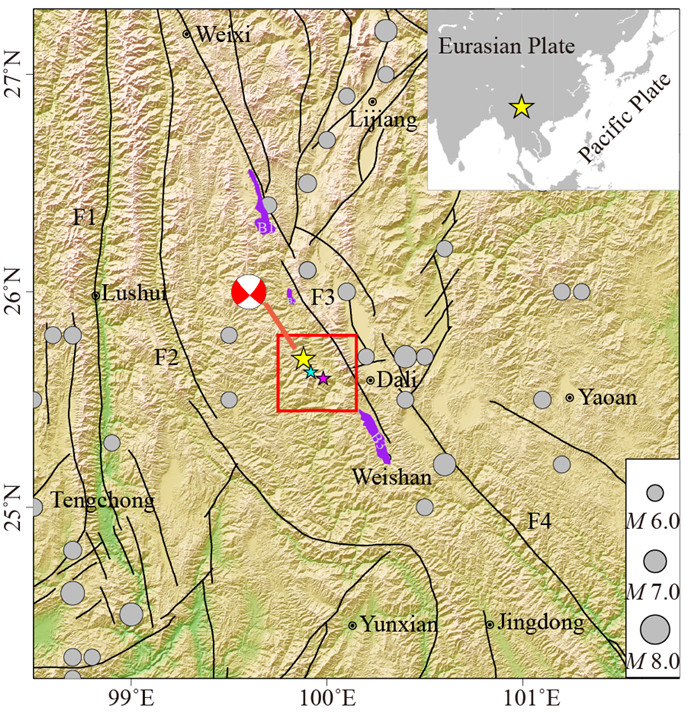
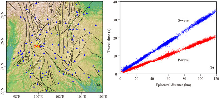
The 2021 Madoi M7.4 Earthquake in Qinghai is a major earthquake that occurred in the Bajankara Block of Qinghai-Tibet Plateau in the past 30 years, which spatially filled the seismogenic gap in the eastern section of the northern boundary of the block. Here we determined the values of ML, MS_BB, mB, MWp, MWW, Mdt, and M (GNSS) by abundant regional and global seismic and geodetic observations, which is 6.61, 7.43, 7.18, 7.33, 7.43, 7.38, and 7.4, respectively. To compare the time efficiency and stability of different magnitude scales, we generated a real-time environment, to iteratively determine the magnitudes over elapsed times. Some methods such as mB, MS_BB, MWp gave considerable variations of as large as 0.5 units for the determined magnitudes with elapsed time, as more data were included. Others such as MWW and Mdt were very stable with increasing data over time. The systematic calculations of various magnitude scales in this study quantitively evaluated the stability and accuracy of those methods, shading light on the adaptability and applicability of different magnitude scales.

The Interpretation of Seismogenic Fault of the Maduo Mw 7.3 Earthquake, Qinghai Based on Remote Sensing Images—A Branch of the East Kunlun Fault System
Guanghao Ha, Jinrui Liu, Zhikun Ren, Xiaoxiao Zhu, Guodong Bao, Dengyun Wu, Zhiliang Zhang
2022, 33(4): 857-868. doi: 10.1007/s12583-021-1556-2
Abstract:

On May 22, 2021, a Mw 7.3 earthquake occurred in Maduo County, Qinghai Province with the epicenter of 34.59°N, 98.34°E. The distribution of aftershocks and surface ruptures suggested that the seismogenic structure might be the Jiangcuo fault (JF), ~70 km south of East Kunlun fault (EKLF). Due to the high altitude and sparse human habitats, there are very few researches on the Jiangcuo fault, which makes us know little about the deformation features and even the geometry of Jiangcuo fault. In this study, we used the high-resolution pre-earthquake satellite images to interpret the spatial distribution and geometry of the Jiangcuo fault. Our results show that the Jiangcuo fault strikes nearly east, extending 180-km-long from Eling Lake to east of Changmahe Town. Based on the geometric features, the Jiangcuo fault could be divided into three segments characterized as the linear structures, fault valleys, scarps and systematic offset of channels. The boundary between Bayan Har Block and Qaidam Block is presented as a wide deformation zone named of Kunlun belt that is composed of East Kunlun fault and several branch faults around Anemaqen Mountain. Geometric analysis and deep lithosphere structure around Maduo County suggest that the Jiangcuo fault should be one of branch of East Kunlun fault at south, where the Kunlun fault developed as a giant flower structure. In addition, the seismic hazards potential of Jiangcuo fault should be given enough attention in the future, because west of the Jiangcuo fault, there is a rupture gap between the co-seismic surface ruptures of the 2001 Kunlun, 2021 Maduo and 1937 Huashixia Earthquakes.

A Prediction Method of Ground Motion for Regions without Available Observation Data (LGB-FS) and Its Application to both Yangbi and Maduo Earthquakes in 2021
Jin Chen, Hong Tang, Wenkai Chen, Naisen Yang
2022, 33(4): 869-884. doi: 10.1007/s12583-021-1560-6
Abstract:

Currently available earthquake attenuation equations are locally applicable, and methods based on observation data are not applicable in areas without available observation data. To solve the above problems and further improve the prediction accuracy of ground motion parameters, we present a prediction model referred to as a light gradient boosting machine with feature selection (LGB-FS). It is based on a light gradient boosting machine (LightGBM) constructed using historical strong motion data from the NGA-west2 database and can quickly simulate the distribution of strong motion near the epicenter after an earthquake. Cases study shows that compared with GMPE methods and those based on real-time observation data, the model has a better prediction effect in areas without available observation data and can be applied to Yangbi Earthquake and Maduo Earthquake. The feature importance evaluation based on both information gains and partial dependence plots (PDPs) reveals the complex relationships between multiple factors and ground motion parameters, allowing us to better understand their mechanisms and connections.

Coseismic Slip Distribution of the 2021 Mw7.4 Maduo, Qinghai Earthquake Estimated from InSAR and GPS Measurements
Lihan Xiao, Rui Zheng, Rong Zou
2022, 33(4): 885-891. doi: 10.1007/s12583-022-1637-x
Abstract:

On 22 May 2021, the Maduo Earthquake occurred on a branch fault of the East Kunlun fault in the Bayan Har Block, which provides opportunity to constrain fault geometry and strain accumulation and release for assessment of earthquake hazards. We processed the Sentinal-1A/B SAR images acquired before and after the earthquake, with which we constrained a finite fault model to best fit to the combined data set of downsampled InSAR image and GPS displacements. The inversion indicates that the Maduo event ruptured a 160 km long section striking 286.5° and a dipping 81.39° with rake angle of 4.62°. The model suggests three compact rupture areas with the slip amplitude exceeding 4 m on the main rupture section and the largest slip region is in the east of the epicenter with a slip of approximately 4.6 m below the surface, in a good agreement with the field geological survey. The total geodetic moment is 1.67 × 10²⁰ N·m equivalent to Mw7.44, slightly larger than estimate of the USGS.

Relocation of the Foreshocks and Aftershocks of the 2021 Ms 6.4 Yangbi Earthquake Sequence, Yunnan, China
Ting Yang, Boren Li, Lihua Fang, Youjin Su, Yusheng Zhong, Jingqiong Yang, Min Qin, Yaji Xu
2022, 33(4): 892-900. doi: 10.1007/s12583-021-1527-7
Abstract:

An Ms 6.4 earthquake occurred in Yangbi, Yunnan, China on May 21, 2021, which has obvious foreshock activity and abundant aftershocks. Based on the seismic observation data recorded by the Yunnan Seismic Network three days before and seven days after the mainshock, a double-difference location method was used to relocate 2 133 earthquakes of the Yangbi sequence. Aftershocks are mostly distributed to the southeast of the mainshock in a unilateral rupture pattern. This sequence exhibits a SE-trending linear alignment with a length of about 25 km, and most of the focal depth is above 12 km. Integrated with the seismic distribution and focal mechanism results, we infer that the strike of the seismogenic fault is about 140º, and dipping to the SW. The fault structure revealed by the seismic sequence is complex, with the NW segment exhibiting a steep dip and relatively simple structure of strike-slip rupture and the SE segment consisting of several branching ruptures. The Yangbi Earthquake is a typical foreshock-mainshock-aftershock sequence, and the mainshock is likely triggered by the largest foreshock. This earthquake occurred in the boundary between high- and low-velocity anomalous zone, where is susceptible to generate large earthquakes.

Microfracture Characterization in Sandstone Reservoirs: A Case Study from the Upper Triassic of Syria's Euphrates Graben
Ibrahem Yousef, Vladimir Morozov, Vladislav Sudakov, Ilyas Idrisov
2022, 33(4): 901-915. doi: 10.1007/s12583-021-1488-x
Abstract:

The Euphrates Graben is located in eastern Syria. The Upper Triassic Mulussa F Formation sandstones serve as the primary reservoir intervals in the majority of the graben fields. The study's findings were based on core studies: petrographic examination of thin sections, scanning electron microscope (SEM), imaging of backscatter scanning electron microscope (BSE), X-ray microprobe examinations, and carbon-oxygen stable isotope analysis of microfracture-filling cements. Three of the most common types of microfracture found in the investigated sandstones are intragranular or intracrystalline microfractures, grain boundary or grain-edge microfractures, and transgranular (crossing grains) microfractures. Sandstone microfractures that are open and free of secondary mineralization improve sandstone storage and permeability. However, microfractures that are cemented and filled with secondary mineralization reduce storage and permeability. Common siderite and pyrite cements were identified within the microfractures and the nearby sandstone matrix. Larger anhedral or euhedral siderites are thought to form during shallow burial diagenesis, whereas poikilotopic siderites are thought to form during deep burial diagenesis. Poikilotopic pyrite is believed to be a diagenetic cement, which is attributed to the reduction of iron oxides present in the sediments in the presence of hydrocarbons. Microfractures reflect tectonic, overpressure, and diagenetic origins. Microfractures of tectonic origin are associated with folding and thrust activities over the Euphrates Graben area, and they were formed at the beginning of the Upper Triassic with siderite and pyrite cement equilibration temperatures of approximately 100–105 ℃, and they continued forming from the middle to the end of the Upper Triassic with cement equilibration temperatures of approximately 90–100 ℃ in conjunction with the first phase of the Euphrates Graben. Microfractures related to diagenetic and overpressure processes are tension microfractures and were formed in compression settings during the Upper Triassic.

Overpressure Evolution Recorded in Fluid Inclusions in the Dongpu Depression, Bohai Bay Basin, North China
Xiuyan Liu, Honghan Chen, Xuewei Xiao, Hongan Zhang, Yuwei Wang, Tianwu Xu, Pei Shang, Lingtao Kong
2022, 33(4): 916-932. doi: 10.1007/s12583-020-1375-x
Abstract:

The Dongpu depression, like other depressions in the Bohai Bay Basin, is characterized by overpressure, however, the published studies have not clearly given the overpressure formation mechanism and paleo-pressure evolution history in the Dongpu depression. In addition, the current researches are mainly focused on the northern Dongpu depression, while rare investigation has been conducted in the southern part. In this context, it is urgent to explore the comprehensive overpressure evolution and formation mechanism in the Dongpu depression in academic and industrial fields. This paper provided a systematic analysis of fluid inclusions, including fluid inclusion petrography, microthermometry, vapor phase filling degree measurement and PVT-x modeling. By using homogenization temperature-burial history projection, the trapping time of the oil inclusions are determined. Four pressure evolution stages are identified in both the northern and the southern Dongpu depression. The results indicate that the pressure accumulation stage is derived by disequilibrium compaction and hydrocarbon generation in the northern part because of the salt rock distribution, while the stage is only derived by hydrocarbon generation in the southern part because of no salt rock distribution. The pressure release stages are mainly caused by the tectonic uplifting movements at the end of Dongying and Minghuazhen Formation. The overpressure in most areas in the northern part has been preserved till now, which is considered as a result of the good plasticity and sealing ability of salt rock that prevent the pressure leakage by smearing on the fault. Areas without salt rock distribution show normal pressure, which means the salt rock is an important factor that contributes to the overpressure preservation. However, there are exceptions that in Baimiao and Qiaokou, the overpressure still exists even without salt rock distribution, which is due to fault closure.

Characteristics and Sources of Organic Matter from the Early Cambrian Niutitang Formtion and Its Preservation Environment in Guizhou
Hong Wei, Qinglai Feng, Jianxin Yu, Shan Chang
2022, 33(4): 933-944. doi: 10.1007/s12583-020-1371-1
Abstract:

The Early Cambrian Niutitang Formation on the Yangtze Block is a set of high-quality marine source rock. However, hydrocarbon-forming organisms of these organic-rich shales was poorly understood. In this paper, the results of palynofacies analysis and hydrocarbon-forming organism characteristics of the Niutitang Formation from the Yangtze Block are reported for the first time, and the sedimentary environment is discussed in combination with geochemical data. Palynofacies analysis show that the organic matter (OM) of the Niutitang Formation is mainly composed of amorphous organic matter (AOM), with a small amount of structural organic matter (STOM) and palynomorphs (PL). The results of CONISS (stratigraphically constrained incremental sum of squares) cluster analysis show that the PL can be divided into three zones in the ascending order: Leiosphaeridia-Micrhystridium-fungal zone, algal bloom zone and fungal development zone, corresponding to three stages: transgression, high-stand and regression, respectively. The principal component analysis (PCA) shows that the main hydrocarbon-forming organisms include planktonic green microalgae or dinoflagellates that are related to Leiosphaeridia and Microcystidium. Palynofacies analysis and geochemical data show that the Niutitang Formation was deposited under anoxic or dysoxic condition which was favorable to the enrichment of organic matter.

Occurrence Characteristics of Saline-Lacustrine Shale-Oil in the Qianjiang Depression, Jianghan Basin, Central China
Zhongliang Sun, Zhiliang He, Furong Wang, Yuanjia Han, Sheng He, Yuguang Hou, Jing Luo, Youheng Zheng, Shiqiang Wu
2022, 33(4): 945-962. doi: 10.1007/s12583-020-1110-7
Abstract:

The amount of shale oil and its characterization are key issues in the study of shale oil. At present, many scholars use a variety of methods to evaluate the amount of shale oil, and use the calculated amount of hydrocarbons to analyze its influencing factors; however, there is lack of detailed research on the storage space for shale-oil and it's influencing factors. In view of this issue, gas chromatography (GC), gas chromatography-mass spectrometry (GC-MS), soxhlet extraction (SE), field-emission scanning electron microscopy (FE-SEM), low-temperature nitrogen adsorption (LTNA), high-pressure mercury intrusion (HPMI), and X-ray diffraction (XRD) were used to analyze and compare samples from two wells located in different deposition locations. The unconventional Well BYY2 and BX7s were drilled in the depocenter and distal area of the Qianjiang Formation, respectively. Controlled by differences in the organic matter type and sedimentary environment, the organic matter in Well BYY2, which was found to be characterized by laminar shale, mainly originated from aquatic algae. The results showed that as the total organic carbon (TOC) content increased, the amount of shale-oil in the pores increased. Shale-oil was mostly stored in mesopores and macropores that had been preserved by dolomite minerals of a biogenic origin and also occurred in pores sized 5–200 nm and > 1 μm. Dolomite minerals of a biogenic origin and clay minerals contributed to the occurrence of shale-oil. In comparison, the organic matter in Well BX7 has been greatly influenced by terrestrial organic matter. Pores in the massive mudstones from Well BX7 were determined to be mainly mesopores preserved by clay minerals and quartz, and the shale-oil was mostly stored within the pores of < 40 nm. When the TOC content was ~2.5 wt.%, the generated shale-oil reached saturation. Clay minerals contributed to the occurrence of shale-oil, whereas quartz only contributed to the occurrence of shale-oil in macropores.

Paleo-Environment Reconstruction of the Middle Permian Lucaogou Formation, Southeastern Junggar Basin, NW China: Implications for the Mechanism of Organic Matter Enrichment in Ancient Lake
Dawei Cheng, Chuanmin Zhou, Zhijie Zhang, Xuanjun Yuan, Yinhe Liu, Xingyu Chen
2022, 33(4): 963-976. doi: 10.1007/s12583-020-1073-8
Abstract:

The Middle Permian Lucaogou Formation is the source rock and the main oil shale producing formation in the southeastern Junggar Basin. This study focused on the Lucaogou Formation exposed in two outcrop sections on the northern flank of the Bogda Mountain, namely the Jingjingzigou and Dalongkou sections. Here, we present integrated analysis of the sedimentology, major and trace elements, mineral components and total organic carbon contents. The paleo-environment was reconstructed including provenance, redox conditions, paleo-salinity, chemical weathering intensity and primary organic matter productivity. The results showed that the upper and lower units were deposited in distinct depositional environments with different organic matter accumulation mechanisms. The lower unit was characterized by low lake level, dry climate, fresh-brackish and well-oxygenated water. While during the deposition of the upper unit the lake level rose, climate turned wetter and the bottom water became less oxidized and much saltier. The mechanism of the organic matter accumulation is different for these two units. The preserved organic matters were mainly controlled by the primary productivity in the lower unit and by the redox conditions in the upper unit.

Distribution of Helium Resources in Weihe Basin, Central China: Insight from 3D Magnetic Inversion
Xuliang Feng, Bingqiang Yuan, Yuhong Li, Chunguan Zhang, Lijun Song
2022, 33(4): 977-992. doi: 10.1007/s12583-020-1080-9
Abstract:

There is promising indication of helium-rich natural gas in Weihe Basin. However, the lack of a detailed investigation on the origin and the spatial distribution of helium source rocks (mainly Yanshanian granites) limits the helium potentiality evaluation in Weihe Basin (WB). We performed three-dimensional (3D) inversions of magnetic data in Weihe Basin and its adjacent areas to figure out the crustal thermal structure and the temporal-spatial distribution of deep granite in the basin. Based on this, we have proposed a geological model of helium accumulation and predicted the potential area of helium distribution. The results of 3D magnetic inversion indicate that the granites in the deep Weihe Basin are mostly located at the central and southern parts of the basin, which are connected spatially with the granites in the North Qinling Orogenic Belt. These granites were all derived from large-scale intra-continental orogeny in the Qinling area during the mid-Mesozoic, providing a good material basis for crust-derived helium in the basin. The local uplift of the Curie surface makes the thermal fluid more actively, which contributes to helium accumulation. The faults developed in the WB are the migration pathway of crust-derived helium and the upward migration of the mantle-derived helium. The wells with high percentage helium are mostly located near the Weihe fault and the areas on the south of it. The Wugong-Xi'an-Lantian area in the central and the Lintong-Weinan-Tongguan area in the eastern Weihe Basin are the most promising helium distribution areas. Furthermore, the region from the north of Taibai Mountain to Baoji City in the western Weihe Basin may also be another potential area of Helium resource.

Discovery and Geological Significance of an Indosinian (ca. 244 Ma) Metamorphic Event in the Langshan Area, Western Inner Mongolia, China: New Evidence from Zircon LA-ICP-MS U-Pb Dating
Yan Yan, Runmin Peng, Chen Siyu, Shuangfei Li
2022, 33(4): 993-1006. doi: 10.1007/s12583-020-1112-5
Abstract:

The Langshan Group is an important constituent of the Precambrian metamorphic rocks in the Langshan area. The accurate determination of its metamorphic age is of great scientific significance for the further study of the Precambrian geological evolution in the region. Disputes remain regarding the metamorphism and deformation overprinting of the Langshan Group. This paper presents a detailed study comprising a field geological investigation, petrological observations, and zircon U-Pb aging of garnet-bearing mica quartz schists in the BangBang District. The result of detrital zircon U-Pb dating from the metamorphosed volcanic sedimentary rock series and geological investigation of the garnet-bearing mica quartz schists suggest the strata formed in the Neoproterozoic. The results from cathodoluminescence (CL) image analysis and U-Pb dating of zircons indicate a large number of metamorphic zircons exist in the garnet-bearing mica quartz schists. The metamorphic overgrowth rims of zircon from two samples were analyzed by LA-ICP-MS. The 206Pb/238U weighted average age of ca. 244 Ma of the zircon metamorphism rims represents the timing of Indosinian greenschist-amphibolite facies metamorphism in the Langshan area, which may be in response to the collision-type orogeny of the North China and Siberian plates in the Late Paleozoic. Acid-intermediate magmatic intrusive activities occurred in the Langshan area, and metamorphic events developed at the same time or at a later stage during the closure of the Paleo-Asian Ocean.

Luminescence Dating and Bracketing Time of the Youngest Toba Tuff Deposits in the Quaternary Sediments of Purna Alluvial Basin, Central India
Singh Ajab, K. Srivastava Ashok, Chauhan Naveen
2022, 33(4): 1007-1016. doi: 10.1007/s12583-020-1357-z
Abstract:

Light gray to yellowish brown youngest Toba tuff (YTT) ash, preserved in the Quaternary sediments of India, have been used as a tool to know depositional and bracketing time period of the same in the sediments through applications of luminescence dating to interpret age connotation of various geological events. Pre- and post-tephra sediments of YTT ash beds from Hudki and Sukali areas of Purna alluvial basin, Central India have been optically dated to interpret the depositional age and bracketing time of the tephra within sedimentary sequences. These sediments are yellowish brown, thinly bedded, laminated, silty clay and host laterally extend discontinued beds of 0.15–0.20 m thickness. The ash is light gray, fine grained and powdery in nature, massive to structureless and lacks any sign of retransportation and redeposition, hence, considered as primary in nature. Total four sediment samples, one each from pre- and post-tephra lithounits of both the localities have been dated through optically stimulated luminescence technique (OSL) equipped with single aliquot regenerative (SAR) procedure on the feldspar grains. It shows pre- and post-tephra ages of 57 ± 5 and 70 ± 4 ka respectively for Hudki and 66 ± 5 and 67 ± 4 ka for Sukali localities. These depositional ages suggest that the ash was bracketed within sediments thousands years after YTT eruption. It is correlatable with the previously reported depositional and absolute ages for the YTT ash from the localities of Ghoghara and Khuntheli, Son Valley; Tejpur, Madhumati River Basin and Jwalapuram, Jurreru Valley. These ages also provide an idea about the period of existence of biological communities represented by the remains of faunal and vegetational activities before and during settlement of the YTT ash in the basin area.

Lithostratigraphy and Biostratigraphy Based on Calcareous Nannofossils at the Late Campanian to Thanetian Transition in the Izeh Zone, Southwestern Iran (Eastern Neo-Tethys)
Senemari Saeedeh
2022, 33(4): 1017-1030. doi: 10.1007/s12583-022-1642-0
Abstract:

This study investigates the Gurpi Formation in the northeast of Izeh, southwestern Iran. In this study, 59 species and 34 genera were determined. Biostratigraphy allows the identification of zones CC21 to CC26, which is equivalent to the UC15cTP-UC20dTP that spans the Late Campanian to Late Maastrichtian. Subsequently, the presence of NP1 to NP6, equivalent to CNP1 to CNP8, indicates that the sequence extends to Selandian. Then the Pabdeh Formation, which dates back to Thanetian, covers the sequence. Several major changes were recorded here in order of importance. The first change is the Campanian-Maastrichtian transition, which was identified based on the last occurrence of the Aspidolithus parcus constrictus. Subsequently, the Early/Late Maastrichtian boundary was determined based on the last occurrence of Reinhardtites levis. In addition, another change in the Late Maastrichtian–Early Danian is associated with an abrupt decrease in the richness of nannofossils, although a significant increase in the abundance of Early Paleocene new species has been observed along with the abundance of Thoracosphaera spp. blooms. Eventually, the final change coincides with an increase in Iridium throughout NP1. These changes may indicate changes in environmental conditions in this part of Iran during the Late Cretaceous–Paleogene transition in the eastern Neo-Tethys domain.

Cenozoic Propagated Rifting in the Dangerous Grounds in Response to the Episodic Seafloor Spreading of the South China Sea
Yuanyuan Wang, Yanghui Zhao, Weiwei Ding, Penggao Fang, Jiabiao Li
2022, 33(4): 1031-1046. doi: 10.1007/s12583-020-1064-9
Abstract:

The southern continental margin of the South China Sea has documented multiphase continental rifting corresponding to the propagation of seafloor spreading. Here we investigate three multi-channel seismic reflection profiles across different segments of the Dangerous Grounds with a NE-SW direction. Stratigraphic correlation reveals that the Cenozoic tectono-stratigraphic framework in the Dangerous Grounds is featured with diachronous rifting, which records the successive spreading of East Subbasin and Southwest Subbasin, South China Sea. By reconstructing the tectono-sedimentary evolution history in different segments, we combine the quantification of the brittle extension, tectonic subsidence, as well as the crustal thinning. Results provide evidence that the extensional stress migrated from northeast to southwest with the progressive propagation of the seafloor spreading in the oceanic basin. Besides, the impact of the tectonic propagation persists even after the cessation of seafloor spreading, evidenced by a longer stretching duration in the West-Dangerous Grounds than that in the eastern area. Moreover, a temporary syn-rift subsidence delay synchronously to the spreading of the adjacent oceanic basin is observed along the southern margin. This observation proves the secondary mantle convection during the seafloor spreading in the southern continental margin, which is related to the propagating rift.

Early Warning of Heavy Metal Pollution after Tailing Pond Failure Accident
Yonggui Wang, Yinqun Yang, Qiang Li, Yaxin Zhang, Xiaolong Chen
2022, 33(4): 1047-1055. doi: 10.1007/s12583-020-1103-6
Abstract:

Heavy metal pollution is a major issue after tailing pond failure accident. It is important to predict pollution trends for limited data of pollution sources. A simple phase separation heavy metal model was built for early warning simulation of heavy metal pollution accidents. Based on this, a new simulation framework has been developed to predict the pollution trends of the downstream according to the measured data at upstream sections. By setting the upstream monitoring date as the inflow boundary condition, the changing processes of heavy metal manganese (Mn) with different phases in the downstream can be accurately simulated and forecasted. Results showed that the concentration of the suspended phase in the downstream was larger than that in the aqueous phase and sediment phase. With this, the early warning of pollution trends after accidents could be made a few days ahead. It indicates that the impact of sediment on heavy metal should not be ignored in the early warning of tailing pond failure accidents.

Small-Scale Heterogeneity and Seismic Anisotropy in the Mid-Mantle: Oceanic Crust versus Meta-Stable Olivine
Xiaobo He
2022, 33(4): 1056-1058. doi: 10.1007/s12583-022-1700-7
Abstract: