Advanced Search

Indexed by SCI、CA、РЖ、PA、CSA、ZR、etc .

2023 Vol. 34, No. 5

COVER
2023, 34(5): .
Abstract:
CONTENTS
2023, 34(5): .
Abstract:
Special Issue on Advances in Geoscience Ontologies and Knowledge Graphs
Guest Editors: Xiumian Hu, Xiaogang Ma, Yunqiang Zhu and Chao Ma
Knowledge System, Ontology, and Knowledge Graph of the Deep-Time Digital Earth (DDE): Progress and Perspective
Xiumian Hu, Yiwei Xu, Xiaogang Ma, Yunqiang Zhu, Chao Ma, Chao Li, Hairong Lü, Xinbing Wang, Chenghu Zhou, Chengshan Wang
2023, 34(5): 1323-1327. doi: 10.1007/s12583-023-1930-1
Abstract:
Carbonate Ontology and Its Application for Integrating Microfacies Data
Yiwei Xu, Xiumian Hu, Zhong Han
2023, 34(5): 1328-1338. doi: 10.1007/s12583-023-1808-4
Abstract:

Carbonate rocks record essential information on changes in paleoclimate and paleoceano-graphy. Abundant geological and geochemical data of carbonate rocks have been accumulated over the past decades; however, most of the data are stored in the published literature with highly unstructured forms, and are thus difficult to reuse. The ontology is a standard knowledge model for data integration, which can promote data storage and reutilization. This study proposes a carbonate ontology that represents the concepts in carbonate microfacies. The carbonate ontology constructed by the top-down process contains 215 terms of classifications and petrographic descriptions of carbonate rocks. Furthermore, carbonate microfacies of the Cretaceous (Aptian) carbonate platform in the Betic Cordillera and Jurassic carbonate platform in Tibet provide the data from case studies for the testing and initial validation of the proposed ontology. The carbonate ontology is under continuous expansion following the bottom-up approach and open access on the website of the deep-time digital Earth (DDE) program.

Paleobiogeographic Knowledge Graph: An Ongoing Work with Fundamental Support for Future Research
Linna Zhang, Zhangshuai Hou, Boheng Shen, Qing Chen, Shaochun Dong, Junxuan Fan
2023, 34(5): 1339-1349. doi: 10.1007/s12583-023-1845-z
Abstract:

Paleobiogeography investigates geographical distributions of fossil organisms and controlling factors that affect their distributions in geological history, to reveal the macro-evolution and coordinated development of life and the environment. It is a crucial window for understanding the biosphere and the geographical environment. After two centuries of development, paleobiogeographic studies have led to the accumulation of significant amounts of knowledge and data; however, the voluminous outputs present the characteristics of an "isolated island" with a scattered, limited number of authoritative definitions of terminologies and semantic heterogeneity among them. This makes data queries cumbersome, the rate of data reuse low, and data sharing more difficult. A knowledge graph (KG) has the advantage of expressing concepts and their semantic relations, which is an important tool for achieving data organization and fusion, and data mining; further, it is also a key technology for realizing the unrestricted sharing of paleobiogeographic information. Through our efforts over the past two years, a paleobiogeographic KG was developed based on the established construction procedure of the KG, which contains 273 concepts, 172 properties, and 47 rules. Meanwhile, the completion of this KG and the construction of a paleobiogeographic platform for display and analysis are now being carried out.

Design and Construction of Lightweight Domain Ontology of Tectonic Geomorphology
Jinglun Xi, Jin Wu, Mingbo Wu
2023, 34(5): 1350-1357. doi: 10.1007/s12583-022-1779-x
Abstract:

As data size grows and computing power evolves, artificial intelligence has become one of the most important tools for assisting data-intensive scientific discoveries. The development of artificial intelligence applications in geoscience requires the understanding of enormous quantities of concepts and thus requires the organization of knowledge into a structured form, which is ontology. Compared with common-sense ontologies, the concepts in geoscience are extremely abstract and difficult to understand. It is challenging to use natural language processing technologies to build ontologies in geoscience from the bottom up. Meanwhile, applications of ontology in deep learning and data integration also reveal the importance of constructing a geoscience ontology. Because of the complexity and transdisciplinary nature, this study focuses on the field of tectonic geomorphology. Based on the understanding and experience of experts in geoscience, a top-down approach is used to construct a tectonic geomorphology ontology as part of the geoscience ontology. This research started with the proposal of a method for constructing ontologies, then built a tectonic geomorphology ontology, and finally checked, validated, and applied the ontology, covering common concepts in geoscience and dedicated concepts in tectonic geomorphology. The tectonic geomorphology ontology is an important part of the whole geoscience ontology.

A New Machine-Learning Extracting Approach to Construct a Knowledge Base: A Case Study on Global Stromatolites over Geological Time
Xiaobo Zhang, Hao Li, Qiang Liu, Zhenhua Li, Claire E. Reymond, Min Zhang, Yuangeng Huang, Hongfei Chen, Zhong-Qiang Chen
2023, 34(5): 1358-1373. doi: 10.1007/s12583-022-1801-3
Abstract:

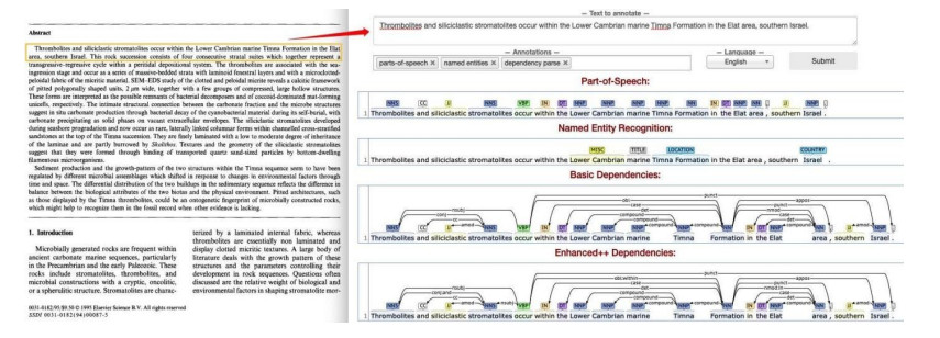
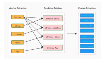
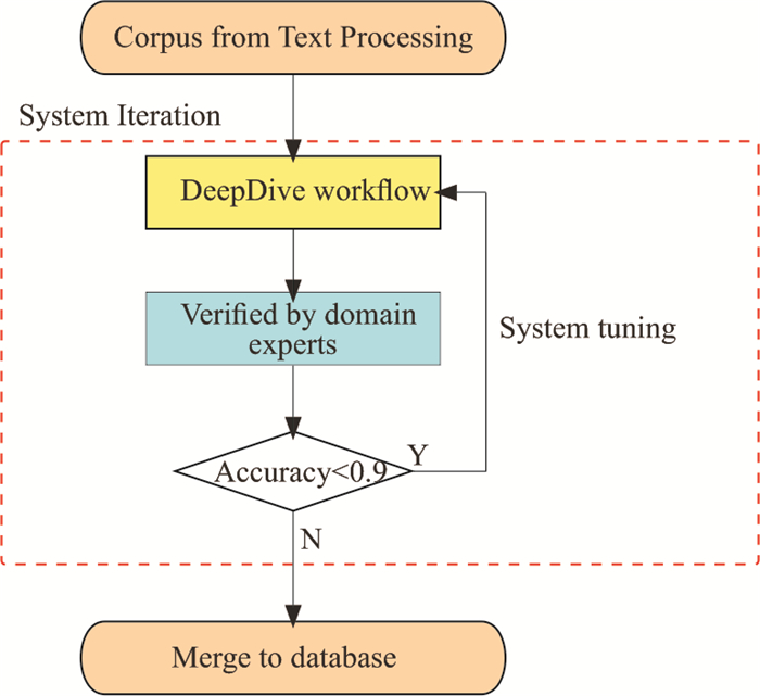
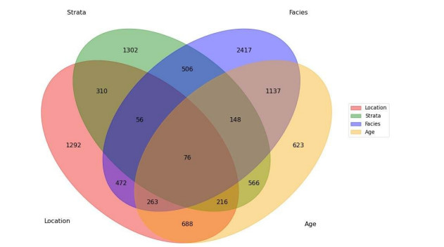
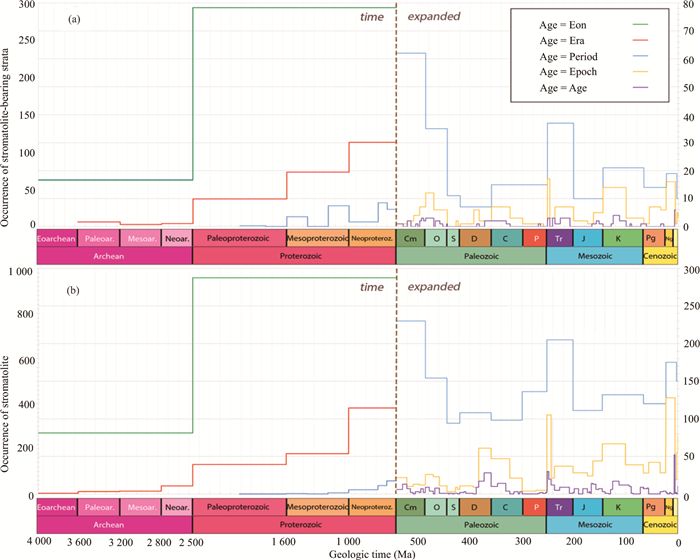
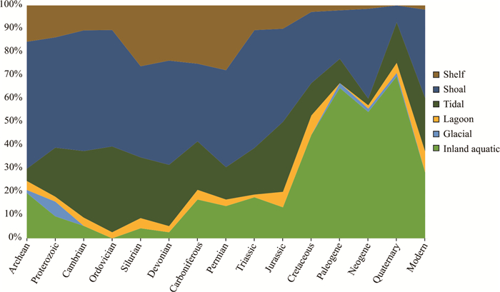
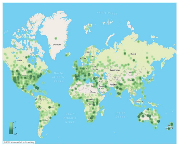
Within any scientific disciplines, a large amount of data are buried within various literature depositories and archives, making it difficult to manually extract useful information from the datum swamps. The machine-learning extraction of data therefore is necessary for the big-data-based studies. Here, we develop a new text-mining technique to reconstruct the global database of the Precambrian to Recent stromatolites, providing better understanding of secular changes of stromatolites though geological time. The step-by-step data extraction process is described as below. First, the PDF documents of stromatolite-containing literatures were collected, and converted into text formation. Second, a glossary and tag-labeling system using NLP (Natural Language Processing) software was employed to search for all possible candidate pairs from each sentence within the papers collected here. Third, each candidate pair and features were represented as a factor graph model using a series of heuristic procedures to score the weights of each pair feature. Occurrence data of stromatolites versus stratigraphical units (abbreviated as Strata), facies types, locations, and age worldwide were extracted from literatures, respectively, and their extraction accuracies are 92%/464, 87%/778, 92%/846, and 93%/405 from 3 750 scientific abstracts, respectively, and are 90%/1 734, 86%/2 869, 90%/2 055 and 91%/857 from 11 932 papers, respectively. A total of 10 072 unique datum items were identified. The newly obtained stromatolite dataset demonstrates that their stratigraphical occurrences reached a pronounced peak during the Proterozoic (2 500–541 Ma), followed by a distinct fall during the Early Phanerozoic, and overall fluctuations through the Phanerozoic (541–0 Ma). Globally, seven stromatolite hotspots were identified from the new dataset, including western United States, eastern United States, western Europe, India, South Africa, northern China, and southern China. The proportional occurrences of inland aquatic stromatolites remain rather low (~20%) in comparison to marine stromatolites from the Precambrian to Jurassic, and then display a significant increase (30%–70%) from the Cretaceous to the present.

A Practical Approach to Constructing a Geological Knowledge Graph: A Case Study of Mineral Exploration Data
Qinjun Qiu, Bin Wang, Kai Ma, Hairong Lü, Liufeng Tao, Zhong Xie
2023, 34(5): 1374-1389. doi: 10.1007/s12583-023-1809-3
Abstract:

Open data initiatives have promoted governmental agencies and scientific organizations to publish data online for reuse. Research of geoscience focuses on processing georeferenced quantitative data (e.g., rock parameters, geochemical tests, geophysical surveys and satellite imagery) for discovering new knowledge. Geological knowledge is the cognitive result of human knowledge of the spatial distribution, evolution and interaction patterns of geological objects or processes. Knowledge graphs (KGs) can formalize unstructured knowledge into structured form and have been used in supporting decision-making recently. In this paper, we propose a novel framework that can extract the geological knowledge graph (GKG) from public reports relating to a modelling study. Based on the analysis of basic questions answered by geology, we summarize and abstract geological knowledge elements and then explore a geological knowledge representation model with three levels of "geological concepts-geological entities-geological relations" to describe semantic units of geological knowledge and their logic relations. Finally, based on the characteristics of mineral resource reports, the geological knowledge representation model oriented to "object relationships" and the hierarchical geological knowledge representation model oriented to "process relationships" are proposed with reference to the commonly used geological knowledge graph representation. The research in this paper can provide some implications for the formalization and structured representation of geological knowledge graphs.

Ontology-Based BERT Model for Automated Information Extraction from Geological Hazard Reports
Kai Ma, Miao Tian, Yongjian Tan, Qinjun Qiu, Zhong Xie, Rong Huang
2023, 34(5): 1390-1405. doi: 10.1007/s12583-022-1724-z
Abstract:

Geological knowledge can provide support for knowledge discovery, knowledge inference and mineralization predictions of geological big data. Entity identification and relationship extraction from geological data description text are the key links for constructing knowledge graphs. Given the lack of publicly annotated datasets in the geology domain, this paper illustrates the construction process of geological entity datasets, defines the types of entities and interconceptual relationships by using the geological entity concept system, and completes the construction of the geological corpus. To address the shortcomings of existing language models (such as Word2vec and Glove) that cannot solve polysemous words and have a poor ability to fuse contexts, we propose a geological named entity recognition and relationship extraction model jointly with Bidirectional Encoder Representation from Transformers (BERT) pretrained language model. To effectively represent the text features, we construct a BERT- bidirectional gated recurrent unit network (BiGRU)-conditional random field (CRF)-based architecture to extract the named entities and the BERT-BiGRU-Attention-based architecture to extract the entity relations. The results show that the F1-score of the BERT-BiGRU-CRF named entity recognition model is 0.91 and the F1-score of the BERT-BiGRU-Attention relationship extraction model is 0.84, which are significant performance improvements when compared to classic language models (e.g., word2vec and Embedding from Language Models (ELMo)).

Extracting Named Entity Using Entity Labeling in Geological Text Using Deep Learning Approach
Qinjun Qiu, Miao Tian, Zhong Xie, Yongjian Tan, Kai Ma, Qingfang Wang, Shengyong Pan, Liufeng Tao
2023, 34(5): 1406-1417. doi: 10.1007/s12583-022-1789-8
Abstract:

Artificial intelligence (AI) is the key to mining and enhancing the value of big data, and knowledge graph is one of the important cornerstones of artificial intelligence, which is the core foundation for the integration of statistical and physical representations. Named entity recognition is a fundamental research task for building knowledge graphs, which needs to be supported by a high-quality corpus, and currently there is a lack of high-quality named entity recognition corpus in the field of geology, especially in Chinese. In this paper, based on the conceptual structure of geological ontology and the analysis of the characteristics of geological texts, a classification system of geological named entity types is designed with the guidance and participation of geological experts, a corresponding annotation specification is formulated, an annotation tool is developed, and the first named entity recognition corpus for the geological domain is annotated based on real geological reports. The total number of words annotated was 698 512 and the number of entities was 23 345. The paper also explores the feasibility of a model pre-annotation strategy and presents a statistical analysis of the distribution of technical and term categories across genres and the consistency of corpus annotation. Based on this corpus, a Lite Bidirectional Encoder Representations from Transformers (ALBERT)- Bi-directional Long Short-Term Memory (BiLSTM)-Conditional Random Fields (CRF) and ALBERT-BiLSTM models are selected for experiments, and the results show that the F1-scores of the recognition performance of the two models reach 0.75 and 0.65 respectively, providing a corpus basis and technical support for information extraction in the field of geology.

Knowledge Graph for Identifying Geological Disasters by Integrating Computer Vision with Ontology
Qinjun Qiu, Zhong Xie, Die Zhang, Kai Ma, Liufeng Tao, Yongjian Tan, Zhipeng Zhang, Baode Jiang
2023, 34(5): 1418-1432. doi: 10.1007/s12583-022-1641-1
Abstract:

The occurrence of geological disasters can have a large impact on urban safety. Protecting people's safety is the most important concern when disasters occur. Safety improvement requires a large amount of comprehensive and representative risk analysis and a large collection of information related to geological hazards, including unstructured knowledge and experience. To address the relevant information and support safety risk analysis, a geological hazard knowledge graph is developed automatically based on computer vision and domain-geoscience ontology to identify geological hazards from input images while obeying safety rules and regulations, even when affected by changes. In the implementation of the knowledge graph, we design an ontology schema of geological disasters based on a top-down approach, and by organizing knowledge as a logical semantic expression, it can be shared using ontology technologies and therefore enable semantic interoperability. Computer vision approaches are then used to automatically detect a set of entities and attributes, using the data from input images, and object types and their attributes are identified so that they can be stored in Neo4j for reasoning and searching. Finally, a reasoning model for geological hazard identification was developed using the Neo4j database to create nodes, relationships, and their properties for modeling, and geological hazards in the images can be automatically identified by searching the Neo4j database. An application on geological hazard is presented. The results show the effectiveness of the proposed approach in terms of identifying possible potential hazards in geological hazards and assisting in formulating targeted preventive measures.

Integrating NLP and Ontology Matching into a Unified System for Automated Information Extraction from Geological Hazard Reports
Qinjun Qiu, Zhen Huang, Dexin Xu, Kai Ma, Liufeng Tao, Run Wang, Jianguo Chen, Zhong Xie, Yongsheng Pan
2023, 34(5): 1433-1446. doi: 10.1007/s12583-022-1716-z
Abstract:

Many detailed data on past geological hazard events are buried in geological hazard reports and have not been fully utilized. The growing developments in geographic information retrieval and temporal information retrieval offer opportunities to analyse this wealth of data to mine the spatiotemporal evolution of geological disaster occurrence and enhance risk decision making. This study pre-sents a combined NLP and ontology matching information extraction framework for automatically re-cognizing semantic and spatiotemporal information from geological hazard reports. This framework mainly extracts unstructured information from geological disaster reports through named entity recognition, ontology matching and gazetteer matching to identify and annotate elements, thus enabling users to quickly obtain key information and understand the general content of disaster reports. In addition, we present the final results obtained from the experiments through a reasonable visualization and analyse the visual results. The extraction and retrieval of semantic information related to the dynamics of geohazard events are performed from both natural and human perspectives to provide information on the progress of events.

Robust Multi-Output Machine Learning Regression for Seismic Hazard Model Using Peak Crust Acceleration Case Study, Turkey, Iraq and Iran
Shaheen Mohammed Saleh Ahmed, Hakan Guneyli
2023, 34(5): 1447-1464. doi: 10.1007/s12583-022-1616-2
Abstract:

This paper for the first time improved a Robust Multi-Output machine learning regression model for seismic hazard zoning of Turkey, Iraq and Iran using constructed 3-D shear-wave velocity (Vs), seismic tomography dataset model for the crust and uppermost mantle beneath the study area. The focus of this paper's opportunity is to develop a scientific framework leveraging machine learning that will ultimately provide the rapid and more complete characterization of earthquake properties. This work can be targeted at improving the seismic hazard zones system ability to detect and associate seismic signals, or at estimating other seismic characteristics (crust acceleration and crust energy) while traditionally, methods cannot monitor the earthquakes system. This work has derived some physical equations for extraction of many variables as inputs for our developed machine learning model based on a reliable understanding of the tomography data to physical variables by preparing huge dataset from diffe-rent physical conditions of crust. We have extracted the velocity values of the shear waves from the original NETCDF file, which contains the S velocity values for every one km of the depths of the crust for the study area from one km down to the uppermost mantle beneath the Middle East. For the first time, this study calculated new seismic hazard parameter called Peak Crust Acceleration (PCA) for seismic hazard analysis by considering the transmitted initial seismic energy through the Earth's crust layers from hypocenter. All machine learning algorithms in this study wrote in python language using anaconda platform the open-source Individual Edition (Distribution).

Kinematic Evolution of the Nyakong-Manyi Shear Zone (Adamawa, Cameroon): Constraints from Field Observations and Microstructures, and Implication for Metamorphic P-T-t Estimation
Belmien Robinson Sobze Yemdji, Jules Tcheumenak Kouémo, Eric Martial Fozing, Ludovic Achu Megnemo, Julios Efon Awoum, Agnes Blandine Kamgang Tchuifong, Brice Rostant Tepi Yemele, Maurice Kwékam
2023, 34(5): 1465-1487. doi: 10.1007/s12583-023-1816-4
Abstract:

The Nyakong-Manyi Shear Zone (NMSZ) is a NE-SW elongated corridor found to the northwest of the Foumban-Bankim Shear Zone (FBSZ) along the Central Cameroon Shear Zone. Controversial chronology models has been proposed for the kinematic evolution of the sinistral and dextral shear phases in the Tikar Plain, thus in the FBSZ; early dextral and late sinistral shear phases for some authors and early sinistral and late dextral shear for others. Moreover, the NMSZ kinematic evolution implication on the mylonitization P-T-t path in the area seem to be problematic and the present paper aim is to clear enough those problems; since this shear zone is the main mylonitic corridor that registered the left and right lateral movement in this area. The NMSZ comprises amphibolites, protomylonites, strict sensus mylonites (garnet-kyanite-sillimanite mylonite and garnet-pyroxene mylonite), ultramylonites kyanite-sillimanite and garnet-kyanite-sillimanite gneiss. Field structures testify that the investigated area recorded three deformation phases: (ⅰ) the D1 deformation phase which is marked by NW-SE to N-S trending S1 metamorphic foliation with low to moderate dips (15°–45°) that was transposed during the D2 phase, is responsible for a regional metamorphism whose mineral paragenesis is garnet-kyanite-sillimanite; (ⅱ) the early sinistral NNE-SSW to NE-SW shear phase D2 marked by S2 metamorphic and mylonitic foliations; responsible for, L2 stretching mineral lineation, F2 fold axes and B2 boudins structures; (ⅲ) the late dextral NE-SW shear phase D3, characterized by F3 folds, B3 boudins and ductile dextral C3 shear planes. Mineral paragenesis garnet + kyanite + sillimanite and microstructures within gneiss testify that this rock underwent high grade regional metamorphism whose peak conditions are estimated at 11.5–13.5 kbar/850–900 ℃. After the peak of metamorphism gneiss was overprinted by high grade pressure mylonitization during the early sinistral and late dextral shear deformations. Microstructural data here indicate a high-grade mylonitization whose P-T conditions are estimated at least at around 10 kbar/750 ℃ attained during the D2. Shear markers, indicates that the studied area underwent an intense mylonitization at deep crustal deformation level, probably at the ductile-brittle boundary structural level during a major dextral shear deformation.

Geochemistry, Petrogenesis and Alteration of Rare-Metal-Bearing Granitoids and Mineralized Silexite of the Al-Ghurayyah Stock, Arabian Shield, Saudi Arabia
Hisham A. Gahlan, Mokhles K. Azer, Paul D. Asimow, Mansour H. Al-Hashim
2023, 34(5): 1488-1510. doi: 10.1007/s12583-022-1708-z
Abstract:

New data are presented for the rare-metal bearing A-type granitoids of the Al-Ghurayyah stock in the northwestern segment of the Arabian Shield, a composite pluton intruding metamorphosed volcano-sedimentary successions of the Silasia Formation. Metals in the granitoids are variably enriched, with up to 1 990 μg/g Zn, 7 680 μg/g Zr, 2 316 μg/g Nb, 232 μg/g Ta, 485 μg/g Hf, 670 μg/g Th, 137 μg/g U and 1 647 μg/g total rare earth elements (REE). The silexite is highly mineralized and yields higher maximum concentrations of several metals than the granitoids, including up to 1 860 μg/g Y, 9 400 μg/g Zr, 878 μg/g Hf, 1 000 μg/g Th, and 2 029 μg/g total REE. The Al-Ghurayyah stock has been assigned to an intraplate setting. Lithospheric delamination led to generation of mantle melts that supplied heat to melt the juvenile crust of the ANS. The fluorine and rare-metal enriched parental magma evolved by fractional crystallization. The quartz-rich silexite, distinct in character from ordinary hydrothermal vein quartz, is inferred to be co-genetic with the granitoids on the basis of their similar REE patterns; it is interpreted as a small volume of residual magma enriched in SiO2, volatiles, and trace metals. Mineralization took place both at the magmatic stage and later during a hydrothermal stage that concentrated these elements to economic grades.

Zircon U-Pb Geochronology of Baoyintu Group in the Northwestern Margin of the North China Craton and Its Geological Significance
Chengwu Ding, Yifei Liu, Pan Dai, Sihong Jiang, Chengzhen Ding
2023, 34(5): 1511-1526. doi: 10.1007/s12583-021-1564-2
Abstract:

The Baoyintu uplift is located at the northwestern margin of the North China Craton (NCC). The affiliation and evolution history of the uplift have been unresolved until now. Here we pre-sent LA-ICP-MS and SHRIMP U-Pb data for zircons extracted from samples of monzogranitic orthogneiss and the Baoyintu Group in the uplift. The 1 679 ± 13 Ma date for the orthogneiss demonstrates that Late Palaeoproterozoic rocks do exist in the uplift. The ca. 1 413 Ma minimum age of detrital zircons in metasedimentary rocks shows that the maximum age of the Baoyintu Group is Mesoproterozoic. The age distribution of detrital zircons in the first unit of the Group form clusters at ca. 2 680, 2 450, 1 800 and 1 560 Ma, which partly correspond to tectonic-magmatic-metamorphic events previously recognised in the NCC, and show that the metasedimentary rocks are largely sourced from different parts of the NCC. These confirm that the Baoyintu uplift is part of the NCC. Amphibolite with a dole-rite protolith from the third unit of Baoyintu Group shows evidence for metamorphism during ca. 877–851 Ma. This combined with published geochronological data indicate the presence of Neoproterozoic magmatic and metamorphic events in the NCC, which significantly increases our understanding of the Proterozoic tectonic evolution of the region and its possible correlation with the Rodinian Supercontinent.

Role of Hematite-Rich Host Rocks in the Gold Mineralization of the Woxi Au (-Sb-W) Ore Deposit in Western Jiangnan Orogen of South China
Jian Zhang, Teng Deng, Deru Xu, Junfeng Dai, Zenghua Li, Bin Li, Yueqiang Zhou
2023, 34(5): 1527-1542. doi: 10.1007/s12583-022-1718-x
Abstract:

The formation of many hydrothermal gold deposits is closely related to iron-rich rocks. The host rocks of the Madiyi Formation of the Mid- to Late Neoproterozoic Banxi Group for the Woxi Au (-Sb-W) deposit, which is located in western Hunan Province of the western Jiangnan Orogen, South China, is rich in hematite, which provides a good example for studying the relationship between the formation of gold deposit and iron-rich rocks. Field investigation and petrographic observation on the unaltered, weakly altered and strongly altered rocks demonstrate that the bleaching is caused by a combination of carbonatization, sulfidation and sericitization. Mass balance calculation suggests that, during decolourization there is no change in TFe2O3, while FeO is gained and Fe2O3 is lost. Geochemical modeling found that Au was mainly present as AuHS(aq) and Au(HS)2-, and that the water-rock interactions decreased the sulfur fugacity which destroyed the stability of such aqueous complexes. Combined with the locally occurred native gold in quartz veins, it is concluded that the major gold precipitation mechanisms are sulfidation and fluid boiling. Based on previous geochronological and geochemical research further gold mineralization is proposed to be generated by deep sourced magmatic or metamorphic fluid migrated upward along the Woxi fault, and the iron-rich Madiyi Formation is the idea chemical trap for gold deposition. The decrease of sulfur contents caused by fluid-rock interactions and fluid boiling are the major mechanisms for gold mineralization.

Different Burial-Cooling History of Triassic Strata between the Western Weibei Uplift and the Northwestern Weihe Basin in Northwest China
Qiang Yu, Zhanli Ren, Rongxi Li, Chung Ling, Tao Ni, Wanshan Lei, Baojiang Wang, Xiaoli Wu, Xiaoli Qin, Xianghe Lei
2023, 34(5): 1543-1555. doi: 10.1007/s12583-021-1432-0
Abstract:

Analysis of tectonothermal history of the Yanchang Formation in the western Weibei Uplift and in the northwestern Weihe Basin can reconstruct the cooling history of the southwest most remained Upper Triassic source rock of the North China Plate. Apatite fission-track (AFT) and (U-Th-Sm)/He (AHe) analysis were used to recover the cooling and uplift history of the Upper Triassic here. Ten sandstones from the Middle–Upper Triassic strata yield AFT ages between 179.8 ± 7.4 and 127.6 ± 8.1 Ma. AHe ages of two sandstones have the value of 37.7 ± 2.3–131.1 ± 8.1 and 45.7 ± 2.8–83.5 ± 5.2 Ma. Time-temperature modeling results showed that tectonothermal history of the Yanchang Formation was initially different in time-space relationships but then became almost identical through time followed by different cooling rate. Modeling results of the Triassic strata in the Qianyang area and the Yaojiagou area revealed three different uplift-cooling stages commencing in the Late Jurassic at ~165 Ma and in Early Cretaceous at ~110 Ma, respectively, both followed by first similar cooling histories to the Early Miocene at ~20–23 Ma and then different since the Late Miocene. Uplift-cooling rate since the Late Miocene at ~8 Ma were different between the Western Weibei Uplift and the Northwestern Weihe Basin. The timing, cooling-uplift rates of the Yaojiagou area, which was mainly controlled by movements related to the Liupanshan Mountains, the Qinling Orogens and the Weibei Uplift, had the earliest onset of uplift-cooling for the Upper Triassic series compared to other regions within the Weibei Uplift. Cooling paths for the Upper Triassic series became uniform regionally in the Early Cretaceous marking a key time for the tectonothermal evolutionary history of Upper Triassic series in the southwestern North China Plate.

Climatic Fluctuation of Marine Isotope Stage 9: A Case Study in the Southern Margin of the Chinese Loess Plateau
Tieniu Wu, Antai Cheng, Henry Lin, Hailin Zhang, Yi Jie
2023, 34(5): 1556-1566. doi: 10.1007/s12583-022-1610-8
Abstract:

Marine Isotope Stages (MIS) 9 has been proposed as an analog for the present warm period. However, detailed studies of this geological time period are rare in loess-paleosol sequence. In the Chinese Loess Plateau (CLP), the corresponding stratum is the third paleosol layer (S3). Here, we report the terrestrial reconstruction of climatic fluctuations during MIS 9 by analyzing the paleo-climate indexes of S3 with high sampling density. Our results showed that: (1) During the period of MIS 9, the main climatic sub-cycle was 29 ka; (2) MIS 9 could be divided into five sections, MIS 9a, 9b, 9c, 9d, and 9e. Among them, MIS 9a, 9c, and 9e were warm stages, while MIS 9b and 9d were cool intervals; and 3) There were also three swift warm-wet events and one cool-dry event, which occurred around 332–331, 324–323, 311–310, and 331–329 ka BP, respectively. The overall trend of paleo-climate fluctuation correlated approximately with SPECMAP, LR04 stack and Iberian margin deep-sea cores. This study suggested that the paleosol records in the southern margin of the CLP have global significance and contain more detailed climatic signals than marine deposits.

Improving the Estimation of Salt Distribution during Evaporation in Saline Soil by HP1 Model
Qian Liu, Yanfeng Liu, Menggui Jin, Jinlong Zhou, P. A. Ferré
2023, 34(5): 1567-1576. doi: 10.1007/s12583-021-1447-6
Abstract:

Restricted by the development of the transient flow and solute reactive transport models for unsaturated soil, empirical functions have been used previously to calculate the mass of dissolved or precipitated salt when they have to be taken into account. Besides, the solute reactive transport process has often been inferred based on measurements that cost lots of time and manpower. HP1 model coupled with PHREEQC provides a suitable tool to improve the estimation of salt distribution during evaporation in saline soil, where the salt dissolution and precipitation cannot be ignored. In this study, we compare the performance of a standard solute transport (SST) model and the HP1 model to examine the improvement of salt distribution estimation. Model results are compared with experimental data sets from four field lysimeters. These columns were exposed to NaCl solution with different concentrations (3, 30, 100, and 250 g/L) and were undergoing the same strong evaporation boundary condition. The pre-existing CaSO4, NaCl and Na2SO4 loads were 1.15, 0.47 and 0.23 g/(100 g of soil), respectively. Simulation results show that HP1 ameliorates the overestimation of salt content by SST in deeper soil due to the absence of dissolution of pre-existing soluble salts, and prevents the concentration of the solute from exceeding the solubilities which would occur in SST-result. Additionally, HP1-predicted results can help trace the transport process of each solute. Based on the results, we strongly suggest that the management of fields sensitive to salt content should make use of a coupled flow and chemical reaction model.

Investigation of Organic Matter Sources and Depositional Environment Changes for Terrestrial Shale Succession from the Yuka Depression: Implications from Organic Geochemistry and Petrological Analyses
Shiming Liu, Lian Jiang, Bangjun Liu, Cunliang Zhao, Shuheng Tang, Furong Tan
2023, 34(5): 1577-1595. doi: 10.1007/s12583-022-1617-1
Abstract:

Continental organic-rich shales are well developed in the Dameigou Formation within the Yuka Depression of the Qaidam Basin. Here, the Rock-Eval pyrolysis, biomarkers, organic petrology, and stable carbon isotope have been carried out on the Middle Jurassic Dameigou Formation source rocks from the northwest part of Yuka Depression, Qaidam Basin in order to study their thermal maturity, source of organic matter (OM), and palaeoenvironment changes. The Rock-Eval pyrolysis data (e.g., Tmax), vitrinite reflectance, and biomarker-derived thermal maturity parameters (e.g., carbon preference index, Ts/(Ts+Tm), C29 Ts/(C29Ts+C29 αβ hopane), C30 αβ/(αβ+βα) hopanes, C29 ααα 20S/(20S+20R) steranes, and C29 αββ/ (αββ+ααα) steranes) suggest all studied samples stay between immature and low mature stage. The maceral compositions, stable carbon isotope compositions, n-alkane distributions, and biomarker-derived source parameters (e.g., C27/C29 ααα 20R sterane, ternary diagram of C27-C28-C29 steranes, C24 tetracyclic terpane) indicate both aquatic organisms and higher plants are the source of OM in the shales, but land plants are dominant. Generally low gammacerane concentration and environment-related parameters (e.g., cross-plots of C27/C29 ααα 20R sterane vs. Pr/Ph) indicate these source rocks may be derived from lacustrine and fluvial-deltaic environments with fresh water, which is also supported by the variations of stable carbon isotopes from OM in the source rocks. However, the stable carbon isotope compositions of OM in the source rocks were influenced by multiple factors (e.g., source types and depositional environment) in the Yuka Depression. Slightly brackish condition is recorded in the upper part of the ZK6-1 well favor the formation of lacustrine algae, as confirmed by high contents of C27 steranes and short-chain n-alkanes. The variation of reducing to oxidizing condition of study area is possibly associated with the periodical flooded river-influenced aquatic condition during the deposition of the Middle Jurassic Dameigou Formation.

Active High-Locality Landslides in Mao County: Early Identification and Deformational Rules
Xianmin Wang, Jing Yin, Menghan Luo, Haifeng Ren, Jing Li, Lizhe Wang, Dongdong Li, Guojun Li
2023, 34(5): 1596-1615. doi: 10.1007/s12583-021-1505-0
Abstract:

High-locality landslides are located on slopes at high elevations and are characterized by long sliding distances, large gravitational potential energy, high movement velocities, tremendous kinetic energy, and sudden onset. Thus, they often cause catastrophic damage to human lives and engineering facilities. It is of great significance to identify active high-locality landslides in their early deformational stages and to reveal their deformational rules for effective disaster mitigation. Due to alpine-canyon landforms, Mao County is a representative source of high-locality landslides. This work employs multisource data (geological, terrain, meteorological, ground sensor, and remote sensing data) and time-series InSAR technology to recognize active high-locality landslides in Mao County and to reveal their laws of development. Some new viewpoints are suggested. (1) Nineteen active high-locality landslides are identified by the time-series InSAR technique, of which 7 are newly discovered in this work. All these high-locality landslides possessed good concealment during their early deformational stages. The newly discovered HL-16 landslide featured a large scale and a great slope height, posing a large threat to the surrounding buildings and residents. (2) The high-locality landslides in Mao County were mainly triggered by three factors: earthquakes, precipitation, and road construction. (3) Three typical high-locality landslides that were triggered by different factors are highlighted with their deformational rules under the functions of steep terrain, shattered rocks, fissure-water penetration, precipitation, and road construction. This work may provide clues to the prevention and control of high-locality landslides and can be applied to the determination of active high-locality landslides in other hard-hit areas.

Nanotechnology for Water Treatment: Is It the Best Solution Now?
Moustafa Gamal Snousy, Hassan Mohamed Helmy, Jianhua Wu, M.F. Zawrah, A. Abouelmagd
2023, 34(5): 1616-1620. doi: 10.1007/s12583-023-1928-8
Abstract:
How Many Pathways We Have for the Marine Carbon Neutrality
Jun Sun
2023, 34(5): 1621-1623. doi: 10.1007/s12583-023-1892-5
Abstract:
How does Global Warming Influence Seafloor Stability?
Qiliang Sun
2023, 34(5): 1624-1625. doi: 10.1007/s12583-023-1877-4
Abstract:
Evolution of the Geological Environment and Exploration for Life on Mars
Long Xiao
2023, 34(5): 1626-1628. doi: 10.1007/s12583-023-1929-7
Abstract:
A Cool-Arid Climate with Large Temperature Seasonality Implied by Arboreal Pollen in the Early Holocene, North-Central China
Fang Tian, Meijiao Chen, Qinghai Xu, Xianyong Cao
2023, 34(5): 1629-1631. doi: 10.1007/s12583-023-1920-3
Abstract:
Evidence for the Late Pliocene Aridification in the Eastern Tarim Basin, Northwest China
Hua Zhang, Feng-Lin Lü, Cheng-Lin Liu, Peng-Cheng Jiao, Hui-Jing Yin, Hui Yan, Bao-Cheng Ma, Liang-Liang Zhao, Hong-Chao Liu
2023, 34(5): 1632-1634. doi: 10.1007/s12583-023-1932-z
Abstract:
New Identification of Quaternary Uranium Mineralization at the Mianhuakeng Granite-Related Uranium Deposit, South China
Long Zhang, Fangyue Wang
2023, 34(5): 1635-1640. doi: 10.1007/s12583-023-1933-y
Abstract:
Characterization of Macro- and Meso- Scale Shear Behavior of Soil-Brick Mixtures with Different Contents and Shapes of Brick by Discrete Element Method
Huawei Zhang, Changdong Li, Ni Xie, Wenmin Yao, Yang Ye, Thaw Mon Mon Nang
2023, 34(5): 1641-1644. doi: 10.1007/s12583-023-1942-x
Abstract: