Advanced Search

Indexed by SCI、CA、РЖ、PA、CSA、ZR、etc .

2023 Vol. 34, No. 6

COVER
2023, 34(6)
Abstract:
CONTENTS
2023, 34(6)
Abstract:
Petrology, Geochemistry, and Geodynamics
Plate Tectonics: The Stabilizer of Earth's Habitability
Zhensheng Wang, Junfeng Zhang, Keqing Zong, Timothy M. Kusky, Yanxin Wang
2023, 34(6): 1645-1662. doi: 10.1007/s12583-023-1864-9
Abstract:

Earth is the only planet known to be habitable, and is also unique with its liquid water, and the operation of plate tectonics. The geological record shows that the habitability of our planet can rapidly recover from major disasters or catastrophes, even those that cause mass extinctions. We suggest that plate tectonics, which acts as a link between the shallow and deep, is pivotal for the formation, evolution, and long-term stability of the hydrosphere, atmosphere, lithosphere, and thus life. Plate tectonics links the surface environment with the deep interior of high viscosity, low Reynolds number, low entropy, and low chaos, able to produce a strong healing effect to neutralize catastrophic events. It can transfer the bio-essential elements from the deep interior to the near-surface environment and can recycle toxic elements to the deep. This unique planetary energy and material transfer process of Earth is a continuous, slow-release, and bidirectional cycle, where a change in the surface is slowly buffered by a reaction from the deep, shaping a long-term and stable habitable environment. Therefore, it is considered that plate tectonics is the basic condition for the long-term stable evolution of the Earth's biosphere and the stabilizer of the Earth's habitability.

Review on in situ Isotopic Analysis by LA-MC-ICP-MS
Jie Lin, Ao Yang, Ran Lin, Ji Mao, Zhaochu Hu, Yongsheng Liu
2023, 34(6): 1663-1691. doi: 10.1007/s12583-023-2002-4
Abstract:

The method of LA-MC-ICP-MS has become one choice for the analysis of many isotopic systems due to its relatively low cost, high analysis speed, high spatial resolution, and low matrix effect. However, there are still many challenges in the accuracy, precision, and spatial resolution of in situ isotopic composition determination by LA-MC-ICP-MS, which mainly include: (1) how to improve instrument sensitivity, further improve the spatial resolution, and achieve simultaneous determination of isotopes, multiple isotopes, or isotopes with trace elements in low-content samples? (2) how to deduct and correct interference to improve the accuracy of isotopic determination? (3) how to correct isotope fractionation? (4) how to reduce the matrix effect of isotopes? how to develop matrix-matched reference materials? and (5) how to achieve non-matrix-matched correction of isotopes? The high-sensitivity cone combinations, gas mixture, shield torch, and reasonable detector array can be applied to improve the elemental sensitivity. The interferences include the background interference and the interferences from the matrix elements (the isobaric interference, the polyatomic interference, and doubly charged ions interference). To reduce or even eliminate the interference, commonly used methods including interference elimination, background correction, and interference correction by evaluating with an interference-free isotope. Isotopic fractionation correction mainly involves external standard calibration and internal and pseudo-internal standard normalization. For non-matrix matched calibration, many methods can be applied, such as the femtosecond laser, line scan, low laser energy, wet plasma condition, optical setup below the sample surface, and matching the intensity of the sample and standard. In this review, we systematically summarized the above challenges and solutions to promote the study and application of LA-MC-ICP-MS in isotopic determination.

First Discovery of Late Triassic Tuffs in the South Qilian Basin: Geochemical Characteristics, Zircon LA-ICP-MS U-Pb Ages and Potential Source Regions
Fangpeng Du, Furong Tan, Shiming Liu, Xiaochen Zhao, Yingtao Chen, Junwei Qiao
2023, 34(6): 1692-1703. doi: 10.1007/s12583-021-1446-7
Abstract:

This investigation reports the first discovery of more than 70 tuff intervals in the Upper Triassic, South Qilian Basin. Petrographic and geochemical analyses were carried out on ten tuff samples and zircon U-Pb dating were on three. Thin section and X-ray diffraction (XRD) results indicate that the tuffs were composed of crystal shards and altered glass shards; crystal shards include plagioclase and quartz. Most of the tuffs had been transformed into illite/smectite mixed-layers (I/S). In addition, calcite, pyrite, dolomite and siderite were also identified in some of the tuff samples. Analysis of major elements suggests that the tuffs are peraluminous high-K calcalkaline series. Trace elements indicate that the tuffs are enriched in high field strength elements (HFSE), including Th, U, Ta, Zr and Hf. Geochemical characteristics suggest that the tuffs originated from comendite pantellerite and rhyolite from within plate setting. Zircon U-Pb dating (236.0 ± 1.7, 231.4 ± 1.6, and 223.1 ± 3.9 Ma) indicate that the tuffs were erupted in the Late Triassic. Comparative chronology and geochemical analyses suggest that the West Qinling belt and the East Kunlun belt are the potential source regions of these tuffs, and they originated from the within plate magma during a post-collisional period.

Permian-Triassic Magmatism in the Qin-Fang Tectonic Belt, SW China: New Insights into Tectonic Evolution of the Eastern Paleo-Tethys
Yun Zhou, Yongshan Zhao, Yongfeng Cai, Qiaofan Hu, Ce Wang
2023, 34(6): 1704-1716. doi: 10.1007/s12583-020-1111-6
Abstract:

The granites of ambiguous geodynamic mechanism in the Qin-Fang tectonic belt (SW China) were studied in detail based on petrological, element geochemical, zircon U-Pb geochronological, and Hf isotopic data. LA-ICPMS U-Pb analyses on zircon yield ages of 248–245 Ma for the granites from the Qin-Fang tectonic belt. The geochemical data show that they are high-K, calc-alkaline, and peraluminous series. Their εHf(t) values are from -14.01 to -7.75 with two-stage model ages of 1.74–1.43 Ga. These data, integrated with low Al2O3/TiO2, Rb/Sr, Rb/Ba, and (Na2O + K2O)/(FeOT + MgO + TiO2) ratios, and high CaO/Na2O ratios for the granite, suggest an origin from psammite source which was contaminated by mantle-derived components. These observations, in combination with the age data and stratigraphic records in the Jinshajiang, Ailaoshan, and Hainan Island areas suggest that the granites were formed in a post-collision tectonic setting. The Qin-Fang tectonic belt was likely a branched ocean basin of the eastern Paleo-Tethys.

Water Content and Deformation Fabrics in Layered Gabbros: Implications for Rhythmic Layering and Its Effect on Seismic Properties
Zhonghang Wang, Hao Ye, Junfeng Zhang, Yanguo Fang
2023, 34(6): 1717-1723. doi: 10.1007/s12583-021-1533-9
Abstract:
Calcite U-Pb Geochronology Revealing Late Ediacaran–Early Paleozoic Hydrothermal Alteration in the Stenian-Tonian Carbonate of Northeastern North China Craton
Rong Cao, Hanqing Zhao, Zhongwu Lan
2023, 34(6): 1724-1731. doi: 10.1007/s12583-023-1859-6
Abstract:

Two calcite LA-ICP-MS U-Pb ages of 534 ± 26 Ma (MSWD = 5.9) and 456 ± 43 Ma (MSWD = 3.8) were obtained from the Nanfen Formation, Xihe Group in the southern Liaoning Province, northeastern China, which significantly postdate the theoretical depositional age of sampling horizon. This means they represent timing of post-depositional hydrothermal event possibly induced by synchronous far-field magmatism in the South Qinling. Occurrence of common Pb enriched muddy components coupled with input of "mantle"-like common Pb could account for the relatively low U contents and high common Pb contents in the dated muddy carbonates. We recommend that micro-domains of carbonates are prescreened by rapid in situ carbonate U-Pb geochronology to demonstrate whether they are of primary or secondary origin before utilizing them for chemostratigraphic study.

Geological Structure and Dynamics of the Yinggehai Active Rift Basin, South China Sea
Yue Yao, Shaobin Guo, Xiaopeng Li, Xiaobo Zhao, Shenglin He
2023, 34(6): 1732-1743. doi: 10.1007/s12583-021-1405-3
Abstract:

The Yinggehai Basin is a unique NNW-trending petroliferous basin in the northwestern South China Sea. This paper mainly utilized stratigraphic, tectonic and seismic data by characterizing the geological structures and conducting the geo-mechanical analysis to study the formation, evolution and dynamics of the Yinggehai Basin. The study indicates that the Ailaoshan-Truong Son extruded terrane is composed of multiple secondary extruded bodies. The Red River fault zone, located within the Qiangtang-Simao-Yinggehai mantle flow channel and basin zone, experienced transform-type sinistral strike-slip motion before the basin forming stage and formed a NW-trending extruded mantle uplift, which activated the Yinggehai basin. After experiencing the rift depression, fault depression, and fault subsidence, the basin eventually formed large-scale, thick sedimentation features with ideal hydrocarbon-forming conditions at the end of the Miocene. Later, the basin dynamically transformed and entered a period of tectonic superposition, reworking, and thermal subsidence. Superposition of the NNW thrust sinistral strike-slip fault zone on the northern Hanoi sub-basin complicated the basin structure. Since the Pliocene, the southern Yinggehai main basin has been transformed into an extensional dextral strike-slip environment that hosted numerous mud diapirs. The thin crust and high geothermal gradient provide favorable conditions for the large-scale accumulation of natural gas.

Crustal Electrical Structure of the Wuwei Basin, Lower Yangtze Region of China, and Its Geological Implications
Xiaobo Zhang, Penghui Zhang, Meixing He, Dashuang He, Fagen Pei, Yaoyang Zhang, Yan Peng
2023, 34(6): 1744-1757. doi: 10.1007/s12583-022-1682-5
Abstract:

The Wuwei Basin is one of the most important oil- and gas-bearing basins in the Meso–Cenozoic basin groups in the Lower Yangtze River region. It has great shale gas resource prospects. The formation mechanism of this basin is poorly studied for lack of constraining data for deep structures. In this paper, a crustal electrical structure model of the Wuwei Basin and the adjacent areas is constructed based on the two-dimensional inversion of a magnetotelluric (MT) sounding profile achieved with the nonlinear conjugate gradient method. The results show that large-scale low-resistance bodies have developed in the underlying middle and lower crust of the Wuwei Basin, and are different from the uplifts on the two sides according to their high-resistance electrical characteristics. The electrical structure and regional geological and geophysical data suggest that the peak zone of the Chuzhou-Chaohu foreland fold-and-thrust belt is located on the east bank of the Yangtze River (Wuhu Section), which, together with the main thrust fault belt in the east, forms a typical thrust structure belt. An early Yanshanian sinistral strike-slip fault developed in the deep part of the Wuwei Basin, which may have controlled the formation and evolution of the basin, whereas the tectonic inversion of the early-developed thrust faults is relatively weak. These findings provide a geophysical basis for future studies of basin tectonic evolution and regional tectonic frameworks.

Mineral Deposits
Orogenic Gold Deposits: Mineralization Mechanism and Research Perspectives
Shao-Yong Jiang, Ying Ma, De-Liang Liu, Wen-Tian Li
2023, 34(6): 1758-1761. doi: 10.1007/s12583-023-2005-1
Abstract:
Paleontology and Paleoenvironment
Exceptionally Preserved Conodont Natural Assemblages from the Middle Triassic Luoping Biota, Yunnan Province, China: Implications for Architecture of Conodont Feeding Apparatus
Jinyuan Huang, Carlos Martínez-Pérez, Qiyue Zhang, Kexin Zhang, Mao Luo, Wen Wen, Changyong Zhou, Xiao Min, Zhixin Ma, Tao Xie, Michael J. Benton, Philip C. J. Donoghue
2023, 34(6): 1762-1776. doi: 10.1007/s12583-022-1793-z
Abstract:

Articulated natural assemblages contain direct evidence of the element numbers, morphologies, positions and structures for reconstructing the feeding apparatuses of conodont animals, but these kind of materials are very rare in fossil records. Here we report ten new conodont natural assemblages from Member Ⅱ of the Guanling Formation in Luoping County, eastern Yunnan Province, southwestern China. These assemblages were obtained from the fossil-bearing layers of the Luoping Biota, dated to the early Middle Triassic Anisian stage (Pelsonian substage). These fossiliferous laminated limestones mainly consist of calcites and dolomites, with platy clay minerals and pyrites as subordinate components, indicating that the conodont assemblages were preserved in a lower energy and anoxic sedimentary environment. The new natural assemblages preserve the primary collapse orientations of the Nicoraella feeding apparatus from the Luoping Biota, showing the relative original positions of the S, M and P elements, that could be further used to refine the architecture of this apparatus in space variable M elements and the position unclear P1 elements. Integrating previously reported three-dimensional and bilaterally symmetrical fused clusters, we statistically analyze the size of the positional homogenous elements within different sized materials, in particular S4, S3, or S2 elements, indicates that elements ontogenic changes do not affect the apparatus architecture. Architecture of Nicoraella apparatus remains stable in the process of ontogeny, so our reconstructed model is credible. It is the first time that ample types of materials have been used to restore a conodont apparatus within one genus, namely natural assemblages (articulated and disarticulated), fused clusters (articulated, disarticulated, compressed, and relatively three-dimensional), and abundant discrete elements, respectively. These materials together record the most complete information on architecture in the gondolelloid apparatuses, thus enabling us to reconstruct a reliable fifteen-element apparatus and propose it as a standard template for gondolelloid apparatus reconstruction.

Carbon Isotope from Shallow Marine System in North China: Implications for Stratigraphical Correlation and Sea-Level Changes in Cambrian
Jingxun Zuo, Xuejian Zhu, Yonglin Chen, Wenjian Zhai
2023, 34(6): 1777-1792. doi: 10.1007/s12583-021-1463-6
Abstract:

Cambrian System at the Shatan Section in northern Henan, North China, consists of sedimentary successions of tidal flat and shallow-water carbonate platform facies. Data of carbon isotope (δ13Ccarb) from this section reveals five positive δ13Ccarb (Pst-1–Pst-5) and five negative δ13Ccarb excursions (Nst-1–Nst-5). In the positive excursions, δ13Ccarb rises to 0.88‰, 1.05‰, 2.04‰, 1.00‰ and 2.97‰, respectively, while in the negative excursions δ13Ccarb drops to -8.00‰, -3.50‰, -1.00‰, -0.33‰ and around -2.00‰, respectively. On the basis of chronostratigraphy of Cambrian, the most remarkable carbon isotope excursions can be correlated regionally and globally. In addition, one second-order and ten third-order sequences have been recognized at this section. Correlating third-order sequences and chemostratigraphy indicates that carbonates from the basal part of the transgression system tract (TST) and the upper part of the high-water system (LHST) generally have lighter δ13Ccarb values, whereas massive carbonates with microbialite from the lower part of the high-water system tract (EHST) usually have heavier δ13Ccarb values. The association of δ13Ccarb values with sea-level fluctuations suggests that the positive carbon isotope excursions or high δ13Ccarb values may have been caused by an increase in the marine primary productivity in response to maximum seawater flooding during the transgression.

Carbon Isotope Stratigraphy of the Uppermost Aptian–Lower Cenomanian Strata from the Lut Block, East Iran
Javad Sharifi, Seyed Naser Raisossadat, Maryam Mortazavi Mehrizi, Maryam Motamedalshariati
2023, 34(6): 1793-1799. doi: 10.1007/s12583-023-1911-4
Abstract:

The Mid-Cretaceous interval has been recognized as a crucial period in Earth's history, and a number of studies on Neo-Tethyan successions illustrate intense evolutions in the nature of Mid-Cretaceous ocean chemistry, sea level, and marine faunal communities. However, much less investigations have been conducted in the Sistan Ocean, in the eastern Neo-Tethys. Here, the Nimbolook Section (Lut Block, central Iran) has provided an opportunity to address these shortcomings and provide a better understanding of the paleoenvironmental changes in this region. The biostratigraphic analysis and age interpretation of the Nimbolook Section have been performed in earlier investigations by means of planktonic foraminifera, ammonites and calcareous nannofossils. This provides a reliable age framework for the chemostratigraphic interpretations. In the Nimbolook Section, the δ13C stratigraphy was carried out on a total of 41 samples, which ranged between -3.26‰ and 2.86‰ with an average of 1.09‰ (standard deviation = 1.15‰), and expanded within the upper Aptian to lower Cenomanian stages. However, there is a prominent negative shift at the base of the section, accompanied by episodes of sea-level fluctuations. Notably, according to the age-diagnostic calcareous nannofossils records, this carbon isotope negative shift (0.88‰ to -3.26‰) straddle between late Aptian and early Albian ages. Furthermore, these new chemostratigraphic observations could be interpreted as being the coeval data from the reference well-studied successions in the other parts of the world, tentatively reflecting the oceanic anoxic event (OAE) 1b.

How to Elucidate Functional Genomic Differences between Extinct Organisms and Their Extant Relatives
Xulong Lai, Guilian Sheng, Junxia Yuan
2023, 34(6): 1800-1802. doi: 10.1007/s12583-023-2006-0
Abstract:
Sedimentary Features and Paleogeographic Evolution of the Middle Permian Trough Basin in Zunyi, Guizhou, South China
Zhichen Liu, Qi Zhou, Ke Liu, Yang Wang, Deng Chen, Yunming Chen, Lin Xiao
2023, 34(6): 1803-1815. doi: 10.1007/s12583-021-1406-2
Abstract:

Based on detailed field surveys, numerous sections and drillcores as well as analyses of lithofacies and sedimentary facies, sedimentary differentiation in the Middle Permian Zunyi (northern Guizhou, South China) trough basin was studied in detail. Caused by activities of the Emeishan mantle plume, the regional extensional setting and the extinguishing of carbonate production factories were shown from Guizhou to Yunnan. Three types of sedimentary enironments were developed in the study area: platform, slope, and basin. In this work, we established a sedimentary model for the study area, identified 14 syndepositional faults, and created the detailed reconstruction of the trough basin via a sedimentological investigation. It is found that the paleogeographic evolution of the study area can be divided into six stages: (1) a pre-rifting stage, (2) rapid rifting and subsidence, (3) stable rifting and subsidence, (4) the second stage of rifting and subsidence, (5) silicification, and (6) regional uplift and denudation. The sedimentary features and paleogeographic evolution of the Maokou Formation in Zunyi show that the platform, slope, and basin sedimentary features coexisted. In addition, the extensional setting and extinguishing of carbonate production factories were important preconditions for the evolution of the platform region in the study area, and the activity of syndepositional faults also played an important role in the paleogeographic evolution of this area.

Diverse Climatic and Anthropogenic Impacts on Desertification in the Middle Reaches of Yarlung Zangbo River Catchment on the Tibetan Plateau
Qi Yu, Xianyan Wang, Zhiyong Han, Xiaodong Miao, Huayu Lu
2023, 34(6): 1816-1826. doi: 10.1007/s12583-022-1658-5
Abstract:

The unique desertification processes occurring under the Alpine climate and ecosystem on the Tibetan Plateau could provide critical clues to the natural and anthropogenic impacts on desertification. This study used the Landsat data to investigate the spatial and temporal distribution of desertification from 1990 to 2020 in two areas (Shannan and Mainling), within the Yarlung Zangbo River Basin. The results show not only distinct spatial patterns but also various temporal changes of desertification. In Shannan, aeolian sand was distributed over wide areas from valley floor to mountain slope, while in Mainling, it is distributed sporadically at the footslope. The aeolian sandy land initially expanded before undergoing long-term shrinkage in Shannan. While in Mainling, it steadily expanded followed by a rapid decrease. These changes are attributed to both climate change and human activites. The increase in temperature causes desertification expansion in Shannan, while favorable climate conditions coupled with decreasing human activity promoted desertification reversal. However, both the expansion and shrinkage of desertification were sensitive to human activity in Mainling. This highlights the diverse responses of desertification to natural and anthropogenic impacts on different backgrounds of climatic and vegetation coverage. A threshold of climatic conditions may control the dominance factors in desertification, shifting from natural to anthropogenic elements.

Geochemical Characterization of Organic Rich Black Rocks of the Niutitang Formation to Reconstruct the Paleoenvironmental Settings during Early Cambrian Period from Xiangxi Area, Western Hunan, China
Rizwan Sarwar Awan, Chenglin Liu, Ashar Khan, Khawaja Hasnain Iltaf, Qibiao Zang, Yuping Wu, Sajjad Ali, Muhammad Amar Gul
2023, 34(6): 1827-1850. doi: 10.1007/s12583-021-1524-x
Abstract:

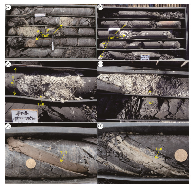
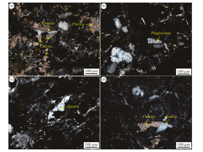
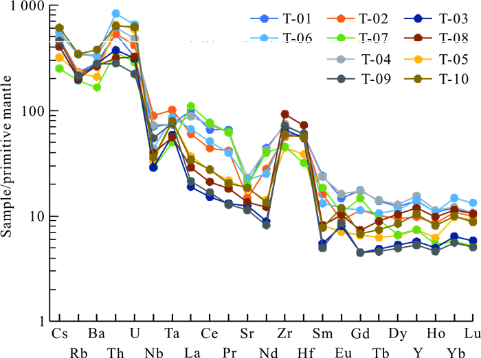
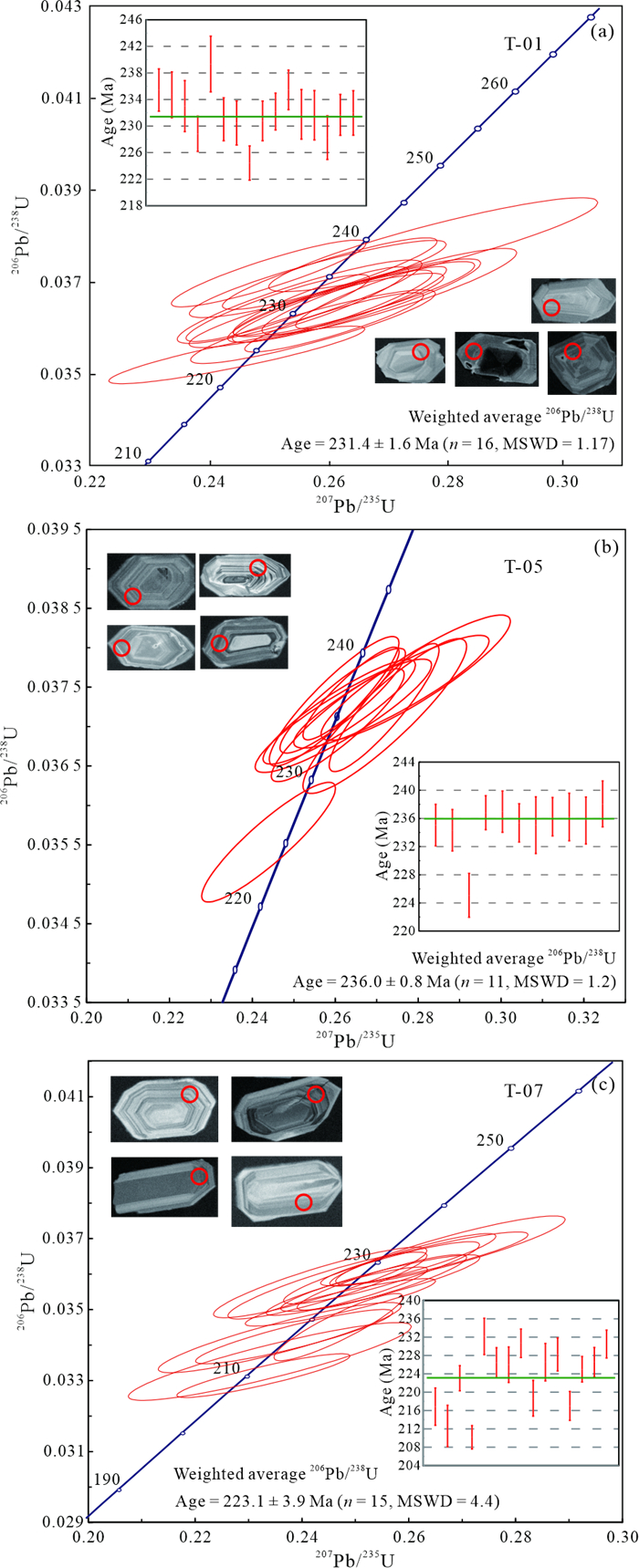
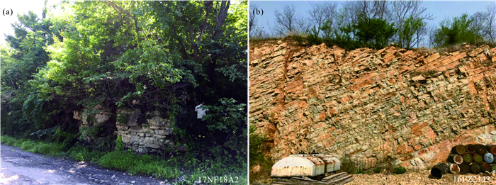
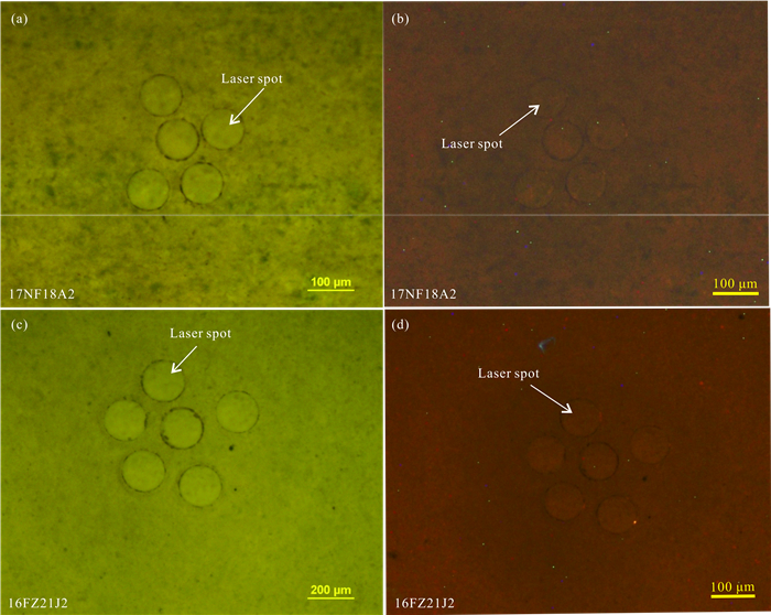
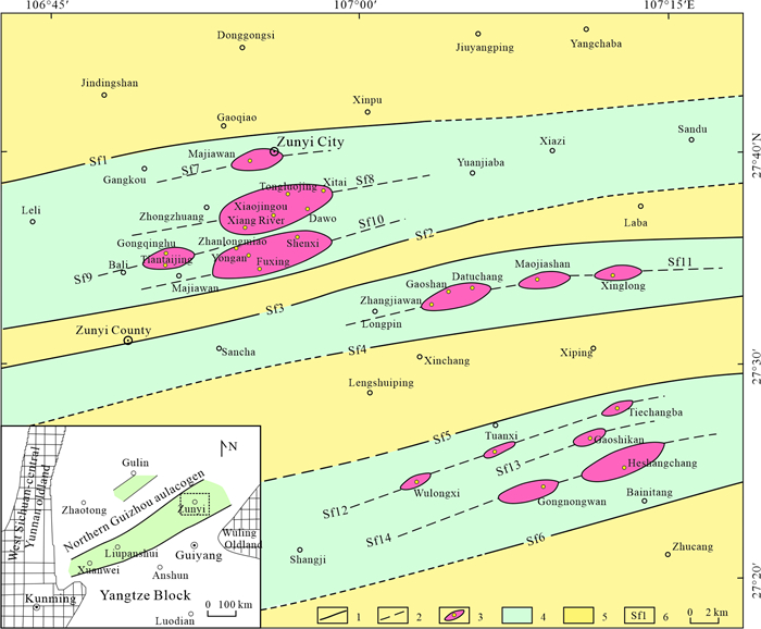
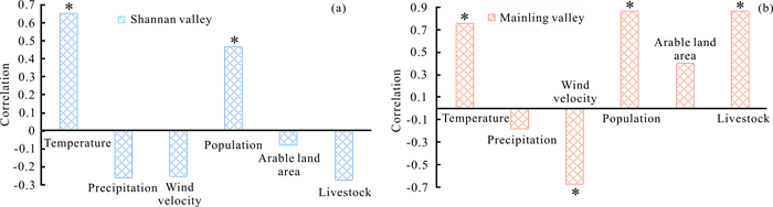
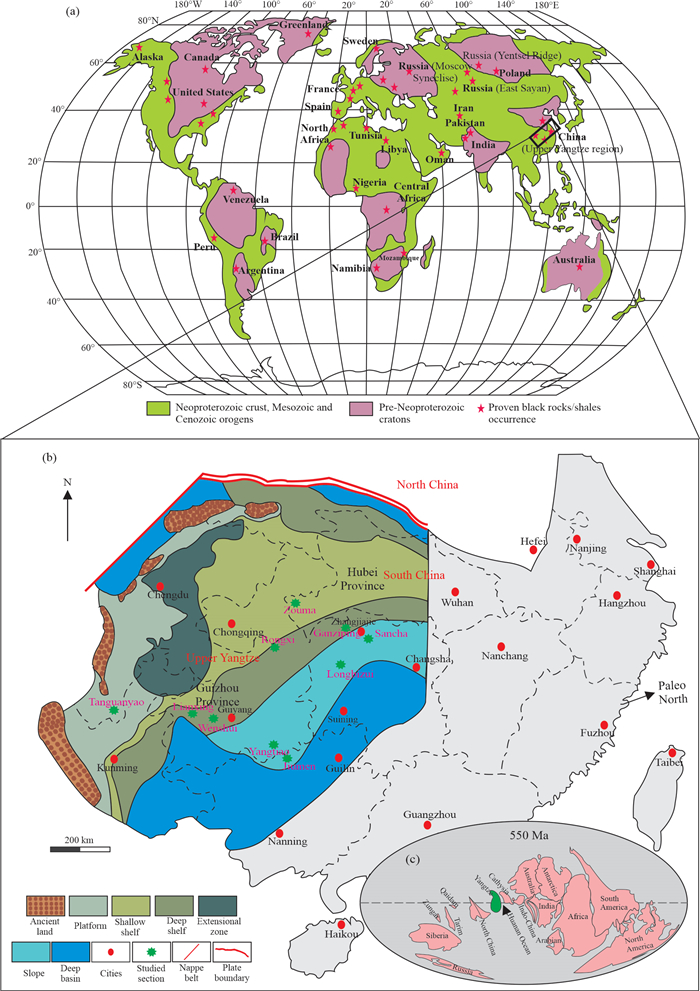
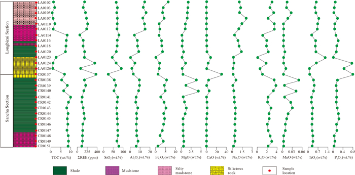
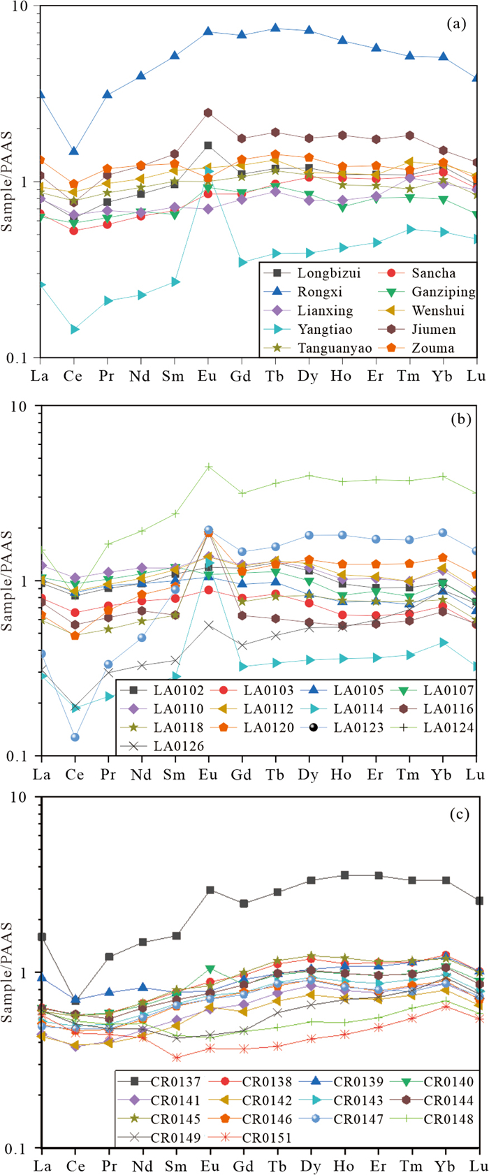
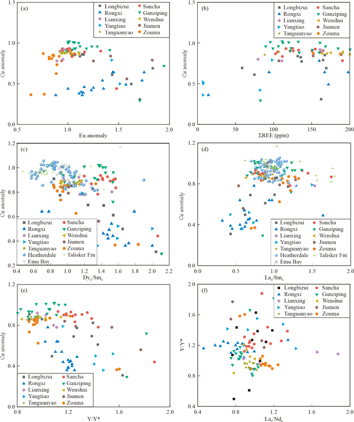
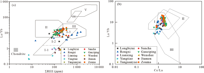
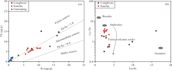
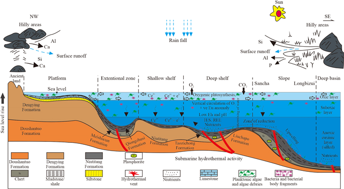
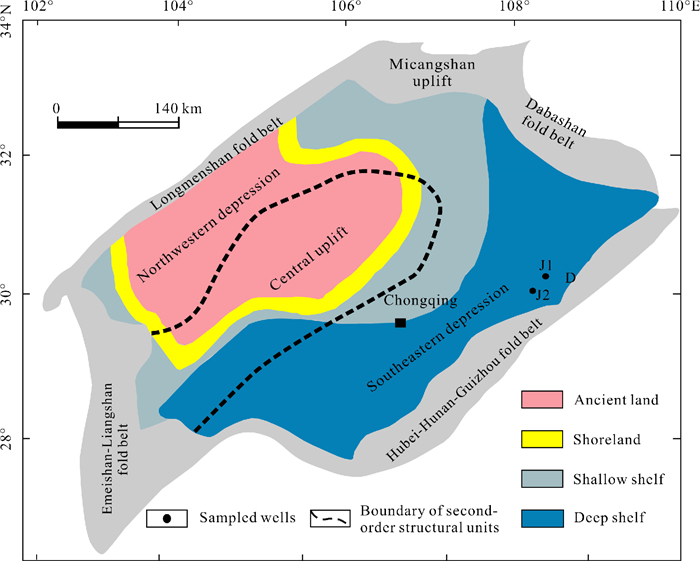
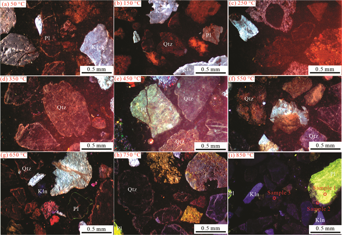
The Niutitang Formation in the South China Block might be a source of hydrocarbon as it contains an enormous quantity of organic matter. Black rock of the Early Cambrian Niutitang Formation is widely distributed in the Yangtze region, but detailed geochemical understanding of it is still emerging. This research discusses the detailed geochemical characteristics of the Niutitang Formation to reconstruct the paleoenvironmental conditions, employing total organic carbon (TOC) content, major, trace, and rare earth element data. For this purpose, black rock specimens of the Niutitang Formation from two outcrop sections were utilized for geochemical characterization, and the results compared with another eight sections from the South China Block. The average total organic carbon in these sediments is significantly higher (5.80 wt.%). In the platform region, lower quantities of TOC indicate a poor potential to produce hydrocarbons. At the same time, significantly higher TOC is observed in the deep shelf and slope sediments, indicating a significant potential to produce hydrocarbons. The average Ce, Eu and Y anomalies from both Longbizui and Sancha sections studied are 0.74, 0.86, 1.77, 1.07, and 1.19, 1.30, respectively. The chemical index of alteration (CAI) throughout the Yangtze block is higher (averaging 71.32) than that of Post Archean Australian Shale (PAAS 69), indicating a moderately weathered source of the Niutitang Formation relative to PAAS. As the sediments are moderately weathered, this suggests these rocks might have been derived from felsic rocks, mainly granite-granodiorite. The normalization of REEs in the black rocks reveals a reduction of light REEs with increase in heavy REEs enrichment. Similarly, a positive Eu anomaly, negative Ce anomaly, and a moderate Y/Ho (34.61) are clues to a hybrid depositional mechanism associated with hydrothermal action and terrigenous input. These anomalies are also evidence of upwelling in the paleo-ocean and mixing of organic matter, which created anoxic bottom water during the deposition of the Niutitang Formation in the basin and upper oxic water conditions before deposition. The main controlling factors for the distribution of rare earth elements in these black rocks of the Niutitang Formation are pH, terrigenous input, source rock composition, tectonism, an upwelling mechanism, and hydrothermal activity.

Petroleum Geology
Quantitative Estimation on Methane Storage Capacity of Organic-Rich Shales from the Lower Silurian Longmaxi Formation in the Eastern Sichuan Basin, China
Xiaowen Guo, Tao Luo, Tian Dong, Rui Yang, Yuanjia Han, Jizheng Yi, Sheng He, Zhiguo Shu, Hanyong Bao
2023, 34(6): 1851-1860. doi: 10.1007/s12583-020-1394-7
Abstract:

The assessment of gas storage capacity is crucial to furthering shale gas exploration and development in the eastern Sichuan Basin, China. Eleven organic-rich shale samples were selected to carry out the high pressure methane sorption, low-pressure N2/CO2 gas adsorption, and bulk and skeletal density measurements to investigate the methane storage capacity (MSC). Based on the relative content of clay, carbonates, quartz + feldspar, we grouped the 11 samples into three lithofacies: silica-rich argillaceous shale (CM-1), argillaceous/siliceous mixed shale (M-2), and clay-rich siliceous shale (S-3). The total porosity of the shale samples varies from 3.4% to 5.6%, and gas saturation ranges from 47% to 89%. The measured total gas amount ranges from 1.84 mg/g to 4.22 mg/g with the ratio of free gas to total gas amount ranging from 52.7% to 70.8%. Free gas with high content in the eastern Sichuan Basin may be the key factor controlling amount of shale gas production. The TOC content critically controls the MSC of shales, because micropore, mesopore volumes and the specific surface areas associated with organic matter provide the storage sites for the free and adsorbed gas. The methane sorption capacities of samples from different lithofacies are also affected by clay minerals and moisture content. Clay minerals can provide additional surface areas for methane sorption, and water can cause a 7.1%–42.8% loss of methane sorption capacity. The total porosity, gas-bearing porosity, water saturation, free gas and adsorbed gas number of samples from different lithofacies show subtle differences if the shale samples had similar TOC contents. Our results suggest that, in the eastern Sichuan Basin, clay-rich shale lithofacies is also prospecting targets for shale gas production.

Quantitative Architectural Anatomy of the Meandering Fluvial Deposits of the Neogene Upper Guantao Formation in Zhanhua Sag, Bohai Bay Basin, China
Yupeng Qiao, Longwei Qiu, Jun Wang, Fan Song, Ziyi Song, Abigail Kuttin
2023, 34(6): 1861-1872. doi: 10.1007/s12583-020-1361-3
Abstract:

The residual oil in the fluvial reservoir of Gudong Oilfield is still widely developed even after decades of development. In order to explore the remaining oil in the subsurface fluvial reservoir, we need to have a better understanding on fluvial sandbody characteristics. This paper aims to demonstrate how to quantify anatomy on meandering fluvial architecture. Sedimentologic data from core descriptions of Guantao Formation in Gudong Oilfield were used to identify architectural elements. The upper Guantao Formation consists of ten lithofacies composing five different types of architectural elements. By integrating the available core, well logs, and seismic data, the fluvial sandbody distribution was analyzed. To characterize the fluvial channel geomorphology, we used seismic inversion to explore the stratigraphic correlation and stacking patterns of different channels, and the sandbody isopach map was obtained by the sandbody thickness in each layer. The architectural elements distribution in the plane was mapped by the sandbody isopach map and its profile characteristics. According to the investigation of meandering fluvial outcrops, subsurface meandering fluvial seismic geomorphology, and modern river morphology, the upstream-bar portions are always eroded because of the downstream channel migration. Statistics on the morphometric parameters (bar width/looplength, upstream deflection angle, downstream deflection angle, etc.) of modern meandering river (Ob River) were obtained from the Google Earth. It is found that the bar width/looplength and upstream deflection angle, upstream deflection angle and downstream deflection angle in modern meandering river have a good relationship, and we can have a quantitative architectural characterization on the point bar. This study quantified lithofacies thickness and proportion in different architectural elements of Guantao Formation, which ensures a high resolution anatomy on the small scale architecture. By using this method, the lithofacies proportion in each architectural element was computed, and through the statistics of architectural elements proportion in the Gudong Oilfield, the different lithofacies proportions in the block 6 can be computed.

Feldspar Geothermometer: A Novel Method Measuring Oilfield Fire-Flooding Temperature
Fengliang Lei, Haitao Shi, Mengyao Gao, Han Xu, Yonglei Zhang, Liang Qiu
2023, 34(6): 1873-1877. doi: 10.1007/s12583-023-2008-y
Abstract:
Engineering Geology and Geo-hazards
Genetic Mechanism of Water-Rich Landslide Considering Antecedent Rainfalls: A Case Study of Pingyikou Landslide in Three Gorges Reservoir Area
Defu Tong, Aijun Su, Fei Tan, Jiandong Tang, Xiongwei Yi
2023, 34(6): 1878-1891. doi: 10.1007/s12583-022-1722-1
Abstract:

Water-rich slope, which could easily fail after prolonged or heavy rain, is very sensitive to rainfall. Pingyikou Landslide is a typical water-rich slope located in the Three Gorges Reservoir area of China. It was unstable because of the continuous rainfall that occurred from September to October 2017. To understand the deformation process and genetic mechanism of the landslide, the geomorphological features, geological characteristics, hydrological conditions, and rainfall characteristics were systematically studied by a detailed field investigation of the slope and monitoring of rainfall, water level, and displacement. In addition, the influence of different initial conditions on the stability of the slope was also studied through numerical simulation using measured rainfall data on the basis of which, the effect of antecedent rainfall on slope stability was studied by unsaturated seepage analysis method. The results show that the deformation of slope is strongly correlated with the rainfall and groundwater level, and this landslide is a typical rainfall-induced landslide. In the analysis of genetic mechanism of the same type of landslide, a maximum initial pore water pressure of -25 kPa as the initial condition is reasonable. And the antecedent rainfall has a greater effect on the stability of the slope, more than 10 days of antecedent rainfall should be considered when designing and controling the slope.

A Comprehensive Method for the Risk Assessment of Ground Fissures: Case Study of the Eastern Weihe Basin
Zhijie Jia, Jianbing Peng, Quanzhong Lu, Penghui Ma, Jianwei Qiao, Feiyong Wang, Mingdong Zang, Yang Liu, Junyan Zhao, Fengji Zhu
2023, 34(6): 1892-1907. doi: 10.1007/s12583-022-1799-6
Abstract:

Ground fissures are influenced by the coupling of geological factors and human activities. They threaten the safety of infrastructure and restrict town planning in many areas in China. One of the area most severely affected by ground fissures is the Weihe Basin in North China, which has the most extensive distribution of ground fissures and all the elements that control their occurrence, providing an ideal study area for the study of ground fissures. In this study, we took the eastern Weihe Basin as the study area and determined the distribution and hazard characteristics of ground fissures via field investigation. Based on the analytic hierarchy process, we propose a multi-level, comprehensive method for evaluating the hazards of ground fissures. This method considers the geological background, development status, and triggering factors of ground fissures, including all nine currently known assessment indices of ground fissures. We used judgment matrices to rank the constructed ground fissure assessment index system at the single and total levels and quantified the nine assessment indices of ground fissures according to the field survey data. Finally, we plotted the ground fissure risk zoning map and evaluated the ground fissure risk at the study area. Our findings indicated that the proposed method could facilitate ground fissure hazard assessment and prediction and provide support for hazard prevention and urban/rural planning.

Long-Term Settlement Characterization of High-Filling Foundation in the Mountain Excavation and City Construction Area of the Yan'an New District, China
Xiaokun Hou, Shengwen Qi, Yongtang Yu, Jianguo Zheng
2023, 34(6): 1908-1915. doi: 10.1007/s12583-023-1950-x
Abstract:

Mountain Excavation and City Construction (MECC) represents a prominent anthropogenic endeavor aimed at facilitating urban expansion in the Loess Plateau of China. It is important to comprehend the long-term settlement behavior at MECC engineering sites to effectively assess the project's success in reshaping landscapes and expanding urban areas. In this study, a typical MECC project, specifically the upstream area of the Liujiagou Valley within the new district of Yan'an City, is selected as a case study to investigate long-term settlement characteristics. The research involved conducting creep tests on soil samples with varying dry densities and moisture content and continuous in-situ monitoring of ground surface settlement at 17 specific points. Furthermore, a numerical model was developed and calibrated using the in-situ monitoring data to predict the long-term settlement. The findings reveal that an increase in soil dry density and a decrease in soil water content contribute to reduced deformation. Notably, settlement primarily manifests within the filled areas, with greater soil thickness exacerbating settlement effects. Over time, cumulative settlement exhibits a progressively diminishing rate of deformation until it attains a stable state. These results provide insights for assessing the long-term stability of MECC projects, facilitating decision-making in future endeavors within this region.

Tensile Behavior Analysis of Loess Using Digital Image Correlation Method
Xin Wei, Ling Xu
2023, 34(6): 1916-1919. doi: 10.1007/s12583-023-2003-3
Abstract:
Rapid Evaluation of Rock Mass Integrity of Engineering Slopes Using Three-Dimensional Laser Scanning
Liang Chen, Yunfeng Ge, Xuming Zeng, Haiyan Wang, Changdong Li, Shan Dong, Yang Ye, Dongming Gu
2023, 34(6): 1920-1925. doi: 10.1007/s12583-023-2007-z
Abstract:
Hydrogeology and Environmental Geology
Assessing the Connectivity of a Regional Fractured Aquifer Based on a Hydraulic Conductivity Field Reversed by Multi-Well Pumping Tests and Numerical Groundwater Flow Modeling
Jingjing Lin, Rui Ma, Ziyong Sun, Liansong Tang
2023, 34(6): 1926-1939. doi: 10.1007/s12583-022-1674-5
Abstract:

Aquifer connectivity could greatly affect groundwater flow and further control the contaminant transport in fractured medium. However, assessing connectivity of fractured aquifer at regional scales is still a challenge because such connectivity is difficult to be measured directly. This study proposes a framework for assessing connectivity of a fractured aquifer, with Qitaihe area, Heilongjiang Province, northeastern China as an illustrating study area. The 3-D finite difference numerical models were established to interpret the results of three multi-well pumping tests and inversely estimate the distribution of hydraulic conductivity (K) in the fractured aquifer. A static connectivity metric of the minimum hydraulic resistance (MHR) was calculated, based on the optimized K-field, to evaluate the hydraulic connectivity in the aquifer, and the corresponding least resistance paths (LRPs) were identified. The results indicate a better horizontal connectivity in the fractured aquifer in the northeastern and middle parts than in the southwestern part of the study area. The identified LRP indicated that the preferential flow channels at regional scales were controlled mainly by aquifer connectivity instead of local high-K zones. The results of this study can provide a method for aquifer connectivity estimation at regional scales.

Seawater Intrusion and Nitrate Contamination in the Fum Al Wad Coastal Plain, South Morocco
Abderrazak Errich, Souad El Hajjaji, Mohamed Fekhaoui, Belkheir Hammouti, Khalil Azzaoui, Abdellatif Lamhamdi, Shehdeh Jodeh
2023, 34(6): 1940-1950. doi: 10.1007/s12583-021-1529-5
Abstract:

The coastal plain aquifer down gradient of Wad Essaquia Elhamra (WEE), is the main source of groundwater in the arid region of Laayoune Essaquia El Hamra located in south of Morocco. The over-exploitation of this aquifer over the last decade for water supply, agriculture and industry led to deterioration of groundwater quality, including seawater intrusion. The objective of this study is to investigate the spatial variation of groundwater quality, and to assess the influence of sea water intrusion on the groundwater quality using hydro-chemical tools. Several measurement campaigns of physico-chemical parameters of the groundwater were performed, which shows a very high mineralization ratios versus chloride, confirming the double influence of mixing mechanisms of fresh and saline waters and the water-rock interactions. Computed seawater fraction for sampled water shows that the average mixing rate of seawater intrusion reached 10.5%, confirming the marine intrusion in the aquifer. The highest values were registered in coastal wells. In the upstream around Laayoune and the spreading area, nitrate concentrations exceed 50 mg/L which is the threshold set by the World Health Organization, revealing a high level of contamination by domestic sewage. The combination of ionic ratios and seawater fraction is a useful tool to assess marine intrusion. This study reveals that the phenomenon of marine intrusion is not the only process that dominates hydrochemistry of ground water. The high groundwater mineralization is also due to rockwater interaction associated with reverse ion exchange with clay material and anthropogenic pollutants.

Biological and Pollution Aerosols on Snow and Ice—Interplay between the Atmosphere and the Cryosphere
Zhiwen Dong, Hongchen Jiang, Giovanni Baccolo, Biagio Di Mauro, Krzysztof Zawierucha
2023, 34(6): 1951-1956. doi: 10.1007/s12583-023-2004-2
Abstract: