| Citation: | Wenkai Chen, Dun Wang, Can Zhang, Qiang Yao, Hongjun Si. Estimating Seismic Intensity Maps of the 2021 Mw 7.3 Madoi, Qinghai and Mw 6.1 Yangbi, Yunnan, China Earthquakes. Journal of Earth Science, 2022, 33(4): 839-846. doi: 10.1007/s12583-021-1586-9

|
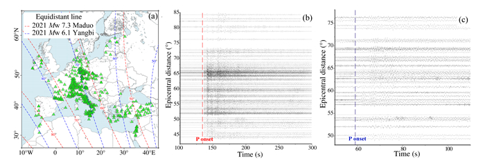
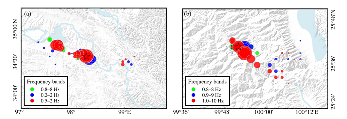
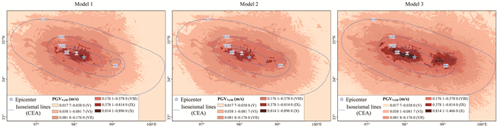
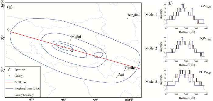
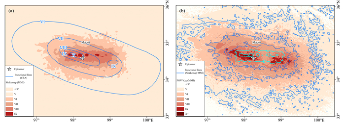
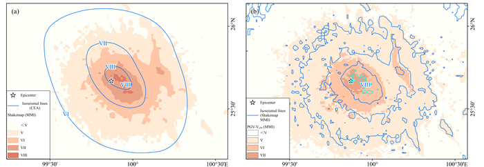
This study focuses on rapidly determining seismic intensity maps of earthquakes because it offers fundamental information for effective emergency rescue and subsequent scientific research, and remains challenging to accurately determine seismic intensity map in regions with sparse instrumental observations. Here we applied a novel method that consisted of array technology (back-projection), ground-motion prediction equations, and site corrections, to estimate the seismic intensity maps of the 2021

| Atkinson, G. M., Wald, D. J., 2007. "Did You Feel It?" Intensity Data: A Surprisingly Good Measure of Earthquake Ground Motion. Seismological Research Letters, 78(3): 362–368. https://doi.org/10.1785/gssrl.78.3.362 |
| Beroza, C. G., 2013. Did You Feel It?. Science, 340(6130): 274–275. https://doi.org/10.1126/science.1235758 |
| Boore, D. M., 2005. Equations for Estimating Horizontal Response Spectra and Peak Acceleration from Western North American Earthquakes: A Summary of Recent Work. Seismological Research Letters, 76(3): 368–369. https://doi.org/10.1785/gssrl.76.3.368 |
| Chen, W. K., Wang, D., Si, H. J., et al., 2022. Rapid Estimation of Seismic Intensities Using a New Algorithm that Incorporates Array Technologies and Ground-Motion Prediction Equations (GMPEs). Bulletin of the Seismological Society of America, 112(3): 1647–1661. https://doi.org/10.1785/0120210207 |
| Cui, H. W., Wan, Y. G., Wang, X. S., et al., 2021. Characteristic of Tectonic Stress Field in Source Region of 2018 MW 7.6 Palu Earthquake and Sulawesi Area. Earth Science, 46(7): 2657–2674. https://doi.org/10.3799/dqkx.2020.243 (in Chinese with English Acstract) |
| Dong, L. G., Shan, J., 2013. A Comprehensive Review of Earthquake-Induced Building Damage Detection with Remote Sensing Techniques. ISPRS Journal of Photogrammetry and Remote Sensing, 84: 85–99. https://doi.org/10.1016/j.isprsjprs.2013.06.011 |
| Fan, X. M., van Westen, C. J., Xu, Q., et al., 2012. Analysis of Landslide Dams Induced by the 2008 Wenchuan Earthquake. Journal of Asian Earth Sciences, 57: 25–37. https://doi.org/10.1016/j.jseaes.2012.06.002 |
| Farhadi, A., Pezeshk, S., 2020. A Referenced Empirical Ground-Motion Model for Arias Intensity and Cumulative Absolute Velocity Based on the NGA-East Database. Bulletin of the Seismological Society of America, 110(2): 508–518. https://doi.org/10.1785/0120190267 |
| Fukushima, Y., Tanaka, T., 1990. A New Attenuation Relation for Peak Horizontal Acceleration of Strong Earthquake Ground Motion in Japan. Bulletin-Seismological Society of America, 80(4): 757–783. https://pubs.geoscienceworld.org/ssa/bssa/article-abstract/80/4/757/102395/A-new-attenuation-relation-for-peak-horizontal |
| Gamba, P., Casciati, F., 1998. GIS and Image Understanding for Near-Real-Time Earthquake Damage Assessment: Remote Sensing and GIS for Hazards. Photogrammetric Engineering & Remote Sensing, 64(10): 987–994 |
| General Administration of Quality Supervision, Inspection and Quarantine. Standardization Administration, 2020. The Chinese Seismic Intensity Scale (GB/T 17742-2020). Standards Press of China, Beijing (in Chinese) |
| Gong, J. H., Wang, D. C., Li, Y., et al., 2010. Earthquake-Induced Geological Hazards Detection under Hierarchical Stripping Classification Framework in the Beichuan Area. Landslides, 7(2): 181–189. https://doi.org/10.1007/s10346-010-0201-4 |
| Ha, G. H., Liu, J. R., Ren, Z. K., et al., 2022. The Interpretation of Seismogenic Fault of the Maduo Mw 7.3 Earthquake, Qinghai Based on Remote Sensing Images—A Branch of the East Kunlun Fault System. Journal of Earth Science, 33(4): 857–868. https://doi.org/10.1007/s12583-021-1556-2 |
| He, X. L., Xu, C., Qi, W. W., et al., 2021. Landslides Triggered by the 2020 Qiaojia Mw 5.1 Earthquake, Yunnan, China: Distribution, Influence Factors and Tectonic Significance. Journal of Earth Science, 32(5): 1056–1068. https://doi.org/10.1007/s12583-021-1492-1 |
| Krüger, F., Ohrnberger, M., 2005. Tracking the Rupture of the Mw = 9.3 Sumatra Earthquake over 1 150 km at Teleseismic Distance. Nature, 435(7044): 937–939. https://doi.org/10.1038/nature03696 |
| Lee, R., Kiremidjian, A. S., 2007. Uncertainty and Correlation for Loss Assessment of Spatially Distributed Systems. Earthquake Spectra, 23(4): 753–770. https://doi.org/10.1193/1.2791001 |
| Liu, K. S., Tsai, Y. B., Lin, P. S., 2013. A Study on Fault-Type and Site-Effect (VS30) Parameters in the Attenuation Relationships of Peak Ground Acceleration and Peak Ground Velocity in Ilan, Taiwan. Bulletin of the Seismological Society of America, 103(3): 1823–1845. https://doi.org/10.1785/0120120065 |
| Matsuoka, M., Yamazaki, F., 2004. Use of Satellite SAR Intensity Imagery for Detecting Building Areas Damaged Due to Earthquakes. Earthquake Spectra, 20(3): 975–994. https://doi.org/10.1193/1.1774182 |
| Midorikawa, S., 1994. Site Effects on Strong-Motion Records Observed during the 1987 Chiba-Ken-Toho-Oki, Japan Earthquake. Environmental Science, 9(3): 85–90 |
| Musson, R. M. W., 2005. Intensity Attenuation in the U.K. . Journal of Seismology, 9(1): 73–86. https://doi.org/10.1007/s10950-005-2979-4 |
| Ohno, S., Ohta, T., Ikeura, T., et al., 1993. Revision of Attenuation Formula Considering the Effect of Fault Size to Evaluate Strong Motion Spectra in near Field. Tectonophysics, 218(1/2/3): 69–81. https://doi.org/10.1016/0040-1951(93)90260-q |
| Pan, J. W., Bai, M. K., Li, C., et al., 2021. Coseismic Surface Rupture and Seismogenic Structure of the 2021-05-22 Maduo (Qinghai) Ms 7.4 Earthquake. Acta Geologica Sinica, 95(6): 1655–1670 (in Chinese with English Abstract) |
| Pathier, E., Fielding, E. J., Wright, T. J., et al., 2006. Displacement Field and Slip Distribution of the 2005 Kashmir Earthquake from SAR Imagery. Geophysical Research Letters, 33(20): L20310. https://doi.org/10.1029/2006gl027193 doi: 10.1029/2006GL027193 |
| Ren, J. J., Zhang, S. M., Hou, Z. H., et al., 2007. Study of Late Quaternary Slip Rata in the Mid Segment of the Tongdian Weishan Fault. Seismology and Geology, 29(4): 756–764 (in Chinese with English Abstract) |
| Ren, Z. K., Zhang, Z. Q., 2019. Structural Analysis of the 1997 Mw 7.5 Manyi Earthquake and the Kinematics of the Manyi Fault, Central Tibetan Plateau. Journal of Asian Earth Sciences, 179: 149–164. https://doi.org/10.1016/j.jseaes.2019.05.003 |
| Sharma, R. C., Tateishi, R., Hara, K., et al., 2017. Earthquake Damage Visualization (EDV) Technique for the Rapid Detection of Earthquake-Induced Damages Using SAR Data. Sensors (Basel, Switzerland), 17(2): 235. https://doi.org/10.3390/s17020235 |
| Si, H. J., Midorikawa, S., 1999. New Attenuation Relationships for Peak Ground Acceleration and Velocity Considering Effects of Fault Type and Site Condition. Journal of Structural and Construction Engineering (Transactions of AIJ), 64(523): 63–70. https://doi.org/10.3130/aijs.64.63_2 (in Japanese) |
| Smith, E. M., Mooney, W. D., 2021. A Seismic Intensity Survey of the 16 April 2016 Mw 7.8 Pedernales, Ecuador, Earthquake: A Comparison with Strong-Motion Data and Teleseismic Backprojection. Seismological Research Letters, 92(4): 2156–2171. https://doi.org/10.1785/0220200290 |
| Song, C., Yao, Q., Wang, D., 2019. Magnitude of the 23 January 2018 M 7.9 Alaska Earthquake Estimated from Local Dense Seismic Records in Alaska. Journal of Earth Science, 30(5): 1005–1009. https://doi.org/10.1007/s12583-019-1215-z |
| Suga, Y., Takeuchi, S., Oguro, Y., et al., 2001. Application of ERS-2/SAR Data for the 1999 Taiwan Earthquake. Advances in Space Research, 28(1): 155–163. https://doi.org/10.1016/S0273-1177(01)00334-9 |
| Thompson, E. M., Wald, D. J., Worden, C. B., 2014. A VS30 Map for California with Geologic and Topographic Constraints. Bulletin of the Seismological Society of America, 104(5): 2313–2321. https://doi.org/10.1785/0120130312 |
| USGS, 2021. M 7.3―Southern Qinghai, China. (2021-05-21). [2022-02-18]. https://earthquake.usgs.gov/earthquakes/eventpage/us7000e54r/shakemap/intensity |
| USGS, 2021. M 6.1―25 km NW of Dali, China. (2021-05-21). [2022-02-18]. https://earthquake.usgs.gov/earthquakes/eventpage/us7000e532/shakemap/intensity |
| Wald, D. J., Quitoriano, V., Heaton, T. H., et al., 1999. TriNet "ShakeMaps": Rapid Generation of Peak Ground Motion and Intensity Maps for Earthquakes in Southern California. Earthquake Spectra, 15(3): 537–555. https://doi.org/10.1193/1.1586057 |
| Wald, D. J., Quitoriano, V., Worden, C. B., et al., 2012. USGS "Did You Feel It?" Internet-Based Macroseismic Intensity Maps. Annals of Geophysics, 54(6): 688–707. https://doi.org/10.4401/ag-5354 |
| Wang, D., Mori, J., 2012. The 2010 Qinghai, China, Earthquake: A Moderate Earthquake with Supershear Rupture. Bulletin of the Seismological Society of America, 102(1): 301–308. https://doi.org/10.1785/0120110034 |
| Wang, D., Takeuchi, N., Kawakatsu, H., et al., 2016. Estimating High Frequency Energy Radiation of Large Earthquakes by Image Deconvolution Back-Projection. Earth and Planetary Science Letters, 449: 155–163. https://doi.org/10.1016/j.epsl.2016.05.051 |
| Wang, D. C., Ni, S. D., Li, J., 2013. Research Status of Rapid Assessment on Seismic Intensity. Progress in Geophys, 28(4): 1772–1784 (in Chinese with Abstract) http://en.cnki.com.cn/Article_en/CJFDTOTAL-DQWJ201304020.htm |
| Wang, W. L., Fang, L. H., Wu, J. P., et al., 2021. Aftershock Sequence Relocation of the 2021 Ms 7.4 Maduo Earthquake, Qinghai, China. Science China Earth Sciences, 64(8): 1371–1380. https://doi.org/10.1007/s11430-021-9803-3 |
| Wang, X. Q., Dou, A. X., Wang, L., et al., 2015. RS-Based Assessment of Seismic Intensity of the 2013 Lushan, Sichuan, China MS 7.0 Earthquake. Chinese Journal of Geophysics, 58(1): 163–171 (in Chinese with Abstract) doi: 10.6038/cjg20150114 |
| Yang, J. W., Ye, B., Gao, Q., et al., 2021. Travel-Time Variations before and after the Yangbi Ms 6.4 Earthquake in 2021 Derived from Active-Source Seismic Data. China Earthquake Engineering Journal, 43(4): 767–776 (in Chinese with English Abstract) |
| Yang, T., Li, B. R., Fang, L. H., 2022. Relocation of the Foreshocks and Aftershocks of the 2021 Ms 6.4 Yangbi Earthquake Sequence, Yunnan, China. Journal of Earth Science, 33(4): 892–900. https://doi.org/10.1007/s12583-021-1527-7 doi: 10.1007/s12583-021-1527-7 |
| Yao, Q., Wang, D., Fang, L. H., et al., 2019. Rapid Estimation of Magnitudes of Large Damaging Earthquakes in and around Japan Using Dense Seismic Stations in China. Bulletin of the Seismological Society of America, 109(6): 2545–2555. https://doi.org/10.1785/0120190107 |
| Yunnan Province Seismological Bureau, 2021. Intensity Map of Yangbi M 6.4 Earthquake in Yunnan Province Released. (2021-05-25). [2022-02-18]. http://www.yndzj.gov.cn/yndzj/_300559/_300651/629959/index.html |
| Zhang, C., Chen, W. K., Si, H. J., et al., 2021. Intensity Rapid Evaluation of Maduo M 7.4 Earthquake in Qinghai Province, 2021. China Earthquake Engineering Journal, 43(4): 876–882 (in Chinese with English Abstract) |
| Zhang, P. Z., Deng, Q. D., Zhang, G. M., et al., 2003. Strong Earthquake Activity and Active Blocks in Chinese Mainland. Scientia Sinica (Terrae), 33(S1): 12–20 (in Chinese with English Abstract) doi: 10.1360/03dz0002 |
| Zhang, H., Ge, Z., 2010. Tracking the Rupture of the 2008 Wenchuan Earthquake by Using the Relative Back-Projection Method. Bulletin of the Seismological Society of America, 100(5B): 2551–2560. https://doi.org/10.1785/0120090243 |
| Zhang, K. L., Gan, W. J., Liang, S. M., et al., 2021. The Coseismic Displacement and Slip Distribution of the 2021 May 21, Ms 6.4, Yangbi Earthquake Derived from GNSS Observations. Chinese Journal of Geophysics: Chinese Edition, 64(7): 2253–2266. https://doi.org/10.6038/10.6038/cjg2021o0524 (in Chinese with Abstract) |
Figures(8)
Copyright © 2013-2020 Journal of Earth Science 鄂ICP备15021562号-2
Tel: +86-27-67885075 Fax: +86-27-67885075 E-mail: xbb@cug.edu.cn
Address: Editorial Office of Journal, China University of Geosciences, Yujiashan, Wuhan, Hubei 430074, P. R. China
Supported by:
Beijing Renhe Information Technology Co. Ltd
E-mail:
info@rhhz.net


 DownLoad: