
Citation: | Xiangjie Wu, Xiong Pang, Hesheng Shi, Min He, Jun Shen, Xiangtao Zhang, Dengke Hu. Deep Structure and Dynamics of Passive Continental Margin from Shelf to Ocean of the Northern South China Sea. Journal of Earth Science, 2009, 20(1): 38-48. doi: 10.1007/s12583-009-0004-5 |
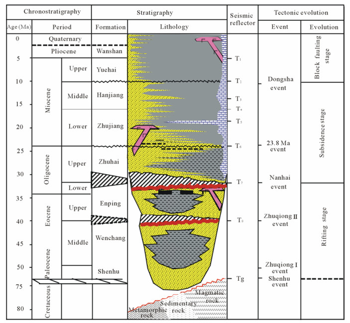
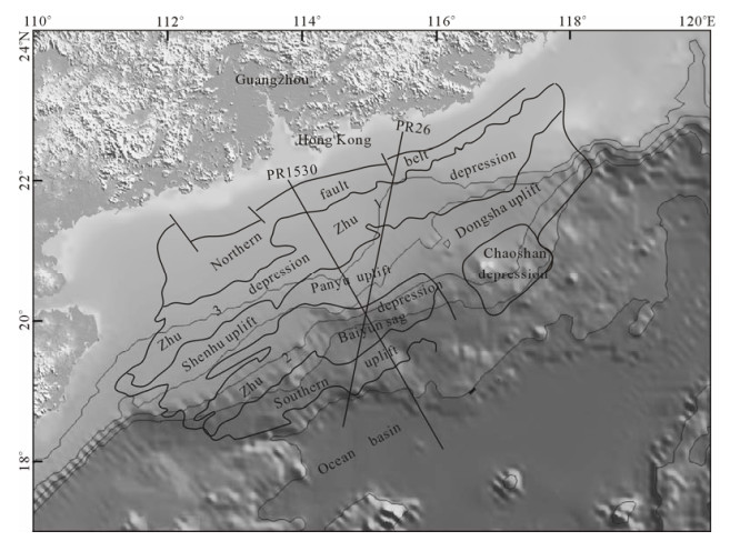
To study the deep dynamic mechanism leading to the difference in rifting pattern and basin structure from shelf to oceanic basin in passive continental margin, we constructed long geological sections across the shelf, slope and oceanic basin using new seismic data. Integrated gravity-magnetic inversion and interpretation of these sections were made with the advanced dissection method. Results show that the basement composition changes from intermediate-acid intrusive rocks in the shelf to intermediate-basic rocks in the slope. The Moho surface shoals gradually from 31 km in the shelf to 22.5 km in the uplift and then 19 km in the slope and finally to 13 km in the oceanic basin. The crust thickness also decreases gradually from 30 km in the northern fault belt to 9 km in the oceanic basin. The crustal stretching factor increases from the shelf toward the oceanic basin, with the strongest extension under the sags and the oceanic basin. The intensity of mantle upwelling controlled the style of basin structures from shelf to oceanic basin. In the Zhu 1 depression on the shelf, the crust is nearly normal, the brittle and cold upper crust mainly controlled the fault development; so the combinative grabens with single symmetric graben are characteristic. In the slope, the crust thinned with a large stretching factor, affected by the mantle upwelling. The ductile deformation controlled the faults, so there developed an asymmetric complex graben in the Baiyun (白云) sag.
The northern South China Sea (SCS) is a passive extensional continental margin, where developed a series of oil/gas-bearing Cenozoic basins, such as the Pearl River Mouth basin (PRMB) (Fig. 1). Affected by thermal perturbation due to mantle upwelling, the deep structure of lithosphere leads to the different rifting patterns from shelf to slope in this passive continental margin, as typified by examples from the PRMB. On the shelf, the basin structure is characterized by combinative grabens or symmetric grabens controlled mainly by faults in the Zhu 1 depression. In the transition from shelf to slope, there developed domino half-grabens in the Panyu uplift. In the lower slope, complex grabens composed of asymmetric grabens developed in the Baiyun sag. Many scientists realized that the lithosphere structure and rheological evolution in passive margin vary from shelf to oceanic basin (Corti et al., 2003; Prodehl et al., 1997), and the deep lithosphere structure led to the difference in basin structure. Basin structure and rifting pattern are very important for understanding petroleum geological conditions. To study the basin structure and to promote petroleum exploration, the China National Offshore Oil Corporation (CNOOC) carried out seismic profiles using the latest technology every year. In this article, we used new seismic data to construct the first long geological sections from shelf to oceanic basin (Fig. 1). Based on the data, we used gravity and magnetic inversion to study the deep lithosphere structure, and according to the result of inversion, we calculated the stretching factor and thus try to discuss the basin structure and dynamic mechanism of this passive continental margin.
The northern margin of the South China Sea lies close to the intersection of three major plates, i.e., the Eurasian, Pacific, and Indian Ocean-Australian plates (Yan et al., 2005; Zhou et al., 1995) and experienced multiple episodes of tectonic movements in the Cenozoic (Chen et al., 2003; Gong and Li, 1997). The basin developed in three stages: rifting, thermal subsidence, and block faulting (Fig. 2) (Zhang et al., 2004; Chen, 2000).
This stage was characterized by large-scale rifting. The Shenhu movement at 54 Ma led the first episode of rifting of the pre-Cenozoic folded basement, as reflected by the unconformity Tg on top of the basement in seismic data. A series of rifting along NNE-NE trend developed, the northern fault belt began to develop. The second and third episodes of rifting were caused by the Zhuqiong I movement at 49 Ma and the Zhuqiong II movement at 39–36 Ma, as reflected by the unconformities T9 and T8 in seismic sections. The continental margin rifted again, a series of rifts along NE-NEE trend developed, the rifting area was enlarged, the deposition rate accelerated, and the framework of PRMB began to form. Corresponding strata are the lacustrine Wenchang and Enping formations.
This stage was characterized by wide subsidence and sea water transgression. The Nanhai movement made the PRMB from rifting stage to post-rifting stage, as reflected by unconformity T7 in the Zhu 1 depression and T6 in the Zhu 2 depression, and a series of faults along EW trend developed. Sea water intruded widely from south to north, and there developed mainly clastic sediments, but reef and carbonate in uplifts and platforms.
This stage started with unconformity T2 and was characterized by faulted block uplifting and sagging in the PRMB. Uplift areas were denuded, such as the Dongsha massif. Old faults were re-activated, and a series of trans-tensional faults along NWW trend developed.
The gravity data came from the satellite gravity data computed from satellite altimetry; we plotted the 2′×2′ gravity field contour map (Fig. 3). The free-air gravity field of the northern SCS is characterized by NEE-striking zones which were cut into blocks along the strike. The northern continental shelf, corresponding to the northern fault belt and the Zhu 1 and 3 depressions, is dominated by low and gentle negative anomalies in the NEE trend, with low anomaly strips of -10 to -20 mGal amplitude. The shelf edge areas, corresponding to the center massif belt, are dominated by high positive gravity anomalies in NW strike, including the Shenhu uplift with amplitude -5 to 20 mGal, gentle and high anomaly in the Panyu uplift with amplitude -5 to 20 mGal, and high anomaly in the Dongsha uplift with high amplitude 0 to 30 mGal. In the western slope area, the Zhu 2 depression, especially the Baiyun sag, is dominated by strong negative gravity anomaly with amplitude -30 to 10 mGal, which was caused by the filling of huge low density Cenozoic sediments. In the eastern slope area, the Chaoshan depression is dominated by positive gravity anomaly with amplitude -5 to 35 mGal, corresponding with high density Mesozoic sediments. The SCS basin shows mainly gentle and positive anomaly with amplitude -20 to 20 mGal, and local anomalies correlated with seamounts. In the continent ocean boundary (COB), there exists an obvious low and negative gravity anomaly belt with amplitude -40 to 0 mGal. It is the boundary effect caused by the abrupt change in density at the COB (Yukari et al., 2001).
The study area lies in the intermediate latitude region where the total magnetic field is inclined. This causes the dislocation of the magnetic field from the magnetic source, and the interpretation becomes difficult. The problem may be overcome by the reduction of magnetic anomaly to the pole (RTP). In this article, we adopted the RTP data of Wang and Dang (2000) (Fig. 4). The magnetic field of the northern SCS is characterized by NEE-striking zones which were cut into blocks by linear anomaly along the NW trend (Chen et al., 2003; Wang et al., 1997). The areas of the Zhu 3 depression, western Zhu 1 depression, Shenhu uplift and western Zhu 2 depression, are dominated by negative low anomaly along the NE trend with amplitude -50 to 100 nT. High magnetic areas, corresponding to Dongsha uplift, eastern Zhu 1 depression, Panyu uplift, the west part of southern massif, have positive anomaly with amplitude 10–200 nT, which was caused by the buried volcanic arc associated with the Late Mesozoic subduction of the paleo-Pacific plate (Zhou et al., 2006). The Baiyun sag is dominated by low negative anomaly with amplitude -100 to 50 nT, which was caused by the huge nonmagnetic Cenozoic and deep basement. Chaoshan depression is also dominated by the gentle low magnetic anomaly with amplitude -100 to 50 nT, which was related to the huge nonmagnetic Mesozoic sediment and deep basement. The anomaly of oceanic basin shows acute changes and the feature of alternative positive and negative strikes along NE or EW trend (amplitude -150 to 150 nT), which was led by the spreading of the South China Sea.
This article tries to discuss the rifting patterns of the passive margin from shelf to oceanic basin and analyze deep dynamic mechanism through gravitymagnetic inversion. For this purpose, a geological section from the shelf to the oceanic basin was constructed based on high resolution seismic data. Two special lines (PR26 and PR1530) with different directions were chosen as the basic data (Fig. 1). PR26 was acquired in 2006 along the NE-SW trend with a total length of 413 km. It is the first long line designed to cross shelf and slope to deepsea basin heretofore. The line PR1530 was the combination of four sections along the NW-SE trend with a total length of 457 km, including the long cable seismic lines collected in 2002 and 2004. The two lines cross the PRMB including the geological units of, from north to south, the northern fault belt, and the Zhu 1 depression in the shelf, the Panyu uplift in the transition from shelf to slope, the Baiyun sag of the Zhu 2 depression in the slope, the Southern uplift, COB, and the central subbasin of the SCS. Both lines are of high resolution and thus favorable for analyzing the structure of the passive margin.
A typical feature of the passive continental marginal basin is the double-layered framework, including the rifting layer at an earlier stage and the thermal subsidence layer at a later stage. But the rifting pattern is different from shelf to oceanic basin. As shown in Fig. 5, in the Zhu 1 depression in the shelf there developed the combinative grabens with single symmetric graben or half-grabens, which is composed of fault blocks. The Panyu low-uplift and the Dongsha massif are composed of domino half-grabens, where sedimentation was controlled by one or several faults with the same inclination, single sag appears dustpan-like asymmetrically, subsidence center closed to the side of sag-controlled faults, stratum attitude appear steep lower and gentle upper, sediment filling change from divergence closed to sag-controlled fault to convergence in uplift, and this style of sag developed in uplift and low uplift. In the slope, the Baiyun sag is an asymmetric complex graben; in the earlier stage the rifting is strongly controlled by large faults on the borders; in the later stage the sag subsided wholly, fault throw was very small and didn't control the sediment, and sediment was overlapped from sag center to two sides.
Multi-channel seismic profiles may provide information of shallow layers such as sediment thickness and faults, but it is difficult to provide deep information such as basement and crustal structure. To analyze deep structures we carried out gravity and magnetic inversion. Although we have high resolution seismic profiles, it is necessary to transit from seismic profile to geological model, so we must make the seismic interpretation and domain transition. According to regional tectonic movement, there developed three regional unconformities, i.e., Tg, T6, and T2. Tg is the acoustic basement and the boundary of Cenozoic and Mesozoic, T6 is the boundary between rifting and post-rifting, and T2 was caused by the block faulting. These three unconformities are not only the tectonic boundaries but also the lithologic interfaces, so we chose these three interfaces to build the model. We must transit the time domain to depth domain. According to VSP data of peripheral wells, we simulated the cubic polynomial to transform time domain to depth domain. The primary model was built, with the layers, from upper to lower, of seabed water body, T0–T2, T2–T6, T6–Tg, crust, and mantle.
After building the model, we selected parameters according to regional geological data, drilling data and previous studies (Fang et al., 2007; Wang et al., 1997). In this area, the basement is composed mainly of Mesozoic intermediate to acid and basic magmatic rocks and Cenozoic basic magmatic rocks. Mesozoic intermediate to acid magmatic rocks show low density and weak magnetism, and Mesozoic and Cenozoic basic magmatic rocks show high density and strong magnetism. Boundary faults were used to divide different geological bodies when considering lateral variation of physical properties, but the lateral density variation of sediments was ignored. Magnetic anomaly is generated mainly by igneous rocks and crystal basement, thus the magnetic susceptibility of sediments was assigned as zero. The parameters are shown in Table 1.
![]() |
In this article, we adopt the dissection method to integrate inversion and interpretation of gravity and magnetic anomalies. The dissection method inverses the residual field through step by step stripping of the field produced by known stratigraphic interfaces or anomaly bodies from the original field (Zhao et al., 2007; Wang et al., 1997). It requests enough information of shallow layers to calculate the original gravity anomaly. Based on our high-quality seismic data and elaborated interpretations, the shallow gravity anomaly generated by the sediment layers above Tg was calculated by forward modeling. By subtracting the shallow gravity anomaly from total gravity anomaly and filtering off noises, the deep gravity anomaly was calculated, which mainly reflects the effect of Moho. From the southern section of PR1530, the Moho surface can be traced from long cable refection seismic data, and the depth of Moho was controlled by the layer velocities given by refraction survey (Huang et al., 2005). In this study, the Moho depth of both lines was estimated by fitting the deep gravity anomalies under the control of the known Moho depth of the southern section of PR1530. Then the anomalous geological bodies were estimated to be under basement and above the upper/lower crustal boundary given by previous studies (Huang et al., 2005; Yan and Liu, 2002; Yukari et al., 2001). In magnetic inversion, Tg is regarded as the top of the crystal basement. Magnetic anomalies caused by igneous rocks above Tg and the magnetic layer between Tg and the upper/lower crustal boundary were simulated by forward modeling. The integrated interpretation of inversion applies the special software of GMDPS developed by the China University of Geosciences.
The gravity and magnetic data along the two lines (Fig. 6) were sliced from respective contour maps (Figs. 3 and 4) because there are no direct observations along both lines. The free-air gravity anomaly along both lines changes from high to low amplitudes from continental shelf to oceanic basin, with the minimum values in the Baiyun sag. The magnetic anomaly is low in the Zhu 1 depression and the Baiyun sag, and high in the Panyu uplift. The latter is the western segment of the high magnetic belt in the northeastern SCS generated probably by the buried Mesozoic volcanic arc (Hu et al., 2008; Zhou et al., 2006).
Results of the inversion (Fig. 6) show that in this area the basement is composed mainly of Mesozoic mid-acid and basic magmatic rocks, Cenozoic basalt, and metamorphic rocks. The crust changes seawards from continent to ocean. In the northern fault belt, the Moho depth is very deep, the crustal thickness is large (32–28 km), the basement consists of Mesozoic mid-acid intrusive rocks with low density and susceptibility, which can be correlated with the basement of the South China coastal zone. In the Zhu 1 depression, it shows low magnetic and gravity anomalies because of filling low density sediments. The basement shows high density and low susceptibility caused by mid-acid granite embedding mid-basic basalt. The Panyu uplift shows high gravity and magnetic anomaly, where the basement is of high density and susceptibility caused by the mid-basic basalt embedded in mid-acid intrusive rocks and locally metamorphic rocks. The Baiyun sag shows very low gravity and magnetic anomaly because it has a thick layer of sediments, and the basement is composed of mid-acid magmatic rocks and embedded basalt. In the southern uplift the gravity and magnetic anomalies are high, as the basement is mainly made of basalt with very high density and susceptibility. In the oceanic basin, the basement is mainly composed of Cenozoic basalt with high density and magnetism. These results show that the density and the susceptibility of basement change significantly from shelf to ocean as the nature of the crust changing from continental to oceanic with the proportion of basalts increases from continental crust to oceanic crust.
The Moho surface shoals gradually from 31 km in the shelf to 22.5 km in the uplift and then 19 km in the slope and finally to 13 km in the oceanic basin. The Moho depth of PR1530 is shallower than that of PR26 because the PR1530 extends to the abyssal plain. From shelf to ocean there are four steps divided by ramps of Moho at the northern fault belt, the shelf break, and the lower continental slope and the ocean continental boundary. The crust thickness also decreases gradually from 30 km in the northern fault belt to 9 km in the oceanic basin. The undulation of Moho mirrors the shape of the basement, so in the depression the Moho upwelled and crust become thin. The interface between upper and lower crust undulates corresponding with that of Moho.
The stretching factor of the crust β= t0/tc was calculated (Fig. 7), where the initial crust thickness t0 was assumed to be 30 km according to regional data (Yao et al., 2005), and tc is the crust thickness from our inversion. In the northern fault belt, the stretching factor is 1.2, nearly a normal curst. The stretching factor of Zhu 1 depression is 1.8, the crust extended and the Moho upwelled with small amplitude. In this area the thickness of the upper crust is almost equal to that of the lower crust. The deformation was mainly brittle, so there developed a group of controlling faults in the early stage, forming combinative grabens with single symmetric graben. In the Panyu uplift, the stretching factor is 1.4, the crust is thick and rigid (Sun et al., 2005), so there developed the domino half-grabens. In the Baiyun sag, the stretching factor reaches 4.5, and the lithosphere strongly extended and thinned, causing the mantle upwelling, and the lower crust was thicker than the upper crust and led to ductile deformation rather than brittle deformation. So there developed asymmetric grabens with no obvious fault control. The sag shows dual character of rifting and sagging. In the southern uplift, the stretching factor is about 2.2. In this area very few boundary faults controlled sag development, and the sags belong to residual sags. In the oceanic basin, affected by the spreading of the South China Sea, the stretching factor reaches 3.2. As the lithosphere thickness decreases from the shelf to the oceanic basin, the nature of the crust changes from normal crust in the shelf, thinned crust in the slope, and oceanic crust in the deepsea basin. As the brittle upper crust becomes thinner, the rifting pattern changes from brittle deformation in the shelf to ductile deformation affected by the mantle upwellings in the slope.
Studies revealed that ductile lower crust had more contribution than brittle upper crust (Zhang et al., 2008). The brittle upper crust controlled the rifting stage with conjugate fractures, while the ductile lower crust controlled crust-mantle thermal effect with ductile flow and extension, which lead to the thermal and rheological changes. Heat flow of the northern South China Sea increases gradually from continental to oceanic basin. Measured heat flow value is 57–59 mW/m2 in the continental margin and 83–89 mW/m2 in the oceanic basin (Zhang et al., 2008). The high surface heat flow is consistent with the thin lithosphere (Liu et al., 2005), which leads to ductile deformation. The crust thinning, mantle upwelling, and high heat flow control the basin structure and style (Wu et al., 2002).
The lithosphere of the northern margin of the South China Sea thinned and rifted under the tensional environment, rifting scale of the basin enlarged from northwest to southeast (Wan et al., 2005), which reflected crust thinning from continent to ocean. Accordingly, the Zhu 1 depression in the continental shelf formed under the brittle extension of cold lithosphere (Li et al., 2006), ductile lower crust and brittle upper crust are relatively thick, heat flow value is low, and upper crust extension leads to combinative horst-grabens and tilting structures (Qi et al., 1995) controlled by basement faults. The Zhu 2 depression in the continental slope was formed mainly under the ductile extension of hot lithosphere. In this area the lower crust is thick and the upper crust is thin as shown by our inversion results. Basin shows dual character of rifting and sagging features with grabens and half-grabens (Lian et al., 2007). After the thinned continental lithosphere was broken eventually by stretching, seafloor spreading started and the deepsea basin of the South China Sea was formed. In the continental shelf and slope, stretching was stopped by stress relaxation, mantle stopped upwelling, and heat flow decreased gradually, which led to the transition from rifting to post-rifting.
According to the analysis of seismic data and inversion of gravity and magnetic data, the following conclusions can be made.
Based on the newest seismic data, we constructed two long geological sections and recognized the different rifting patterns across the shelf to the oceanic basin. In the Zhu 1 depression on the shelf, there developed the combinative grabens with single symmetric graben. In the transition area from shelf to slope, the Panyu uplift and Dongsha massif are composed of domino half-grabens. In the slope, the Baiyun sag is an asymmetric complex graben.
Gravity and magnetic anomaly of the northern South China Sea vary from the shelf to slope. There are low and negative gravity and magnetic anomalies in the continental shelf, high magnetic and high gravity anomalies in the central uplifts, and low gravity anomaly in the slope area caused by the filling of thick sediments in the Baiyun sag. There exists a belt of strong and negative gravity anomaly along the foot of the slope, which was caused by the abrupt change in density at the continent ocean boundary.
The basement composition changes from the shelf to the slope. In the northern shelf, the basement is composed mainly of mid-acid intrusive rocks with low density and susceptibility, the proportion of basalt increases oceanward as the crust thinned and there was deep material upwelling.
The Moho surface shoals gradually from 31 km in the shelf to 22.5 km in the uplift, and then 19 km in the slope and finally to 13 km in the oceanic basin. The crust thickness also decreases gradually from 30 km in northern fault belt to 9 km in the oceanic basin. The crustal stretching factor calculated shows that strong extension occurred under the sags and the oceanic basin. In the northern shelf it was normal crust, and brittle fault developed mainly in the upper crust. In the slope there was thinned transitional crust, and the ductile lower crust is the main factor controlling basin development.
ACKNOWLEDGMENT: Thanks to Professor Zhou Di from South China Sea Institute of Oceanology, Chinese Academy of Sciences for providing helpful discussions in writing this article.Chen, C. M., Shi, H. S., Xu, S. C., et al., 2003. The Condition of Hydrocarbon Accumulation of Tertiary Petroleum System in Pearl River Mouth Basin. Science Press, Beijing (in Chinese) |
Chen, C. M., 2000. Petroleum Geology and Conditions for Hydrocarbon Accumulation in the Eastern Pearl River Mouth Basin. China Offshore Oil and Gas, 14(2): 73–83 (in Chinese with English Abstract) http://search.cnki.net/down/default.aspx?filename=ZHSD200002000&dbcode=CJFD&year=2000&dflag=pdfdown |
Corti, G., Bonini, M., Conticelli, S., 2003. Analogue Modelling of Continental Extension: A Review Focused on the Relations between the Patterns of Deformation and the Presence of Magma. Earth-Science Reviews, 63(3–4): 169–247 http://www.sciencedirect.com/science/article/pii/S0012825203000357 |
Fang, N. Q., Yao, B. C., Wan, L., et al., 2007. The Velocity Structure of the Lithosphere and the Origin of Sedimentary Basins in the South China and Northern Margin of the South China Sea. Earth Science—Journal of China University of Geosciences, 32(2): 147–154 (in Chinese with English Abstract) http://adsabs.harvard.edu/abs/2007agufm.t41a0363d |
Gong, Z. S., Li, S. T., 1997. Continental Margin Basin Analysis and Hydrocarbon Accumulation of the Northern South China Sea. Science Press, Beijing (in Chinese) |
Huang, C. J., Zhou, D., Sun, Z., et al., 2005. Deep Crustal Structure of Baiyun Sag, Northern South China Sea Revealed from Deep Seismic Reflection Profile. Chinese Science Bulletin, 50(11): 1131–1138 doi: 10.1360/04wd0207 |
Hu, D. K., Zhou, D., Wu, X. J., et al., 2008. Origin of High Magnetic Anomaly Belt in Northeastern South China Sea as Indicated by Geophysical Inversion. Journal of Tropical Oceanography, 27(1): 32–37 (in Chinese with English Abstract) http://en.cnki.com.cn/Article_en/CJFDTOTAL-RDHY200801007.htm |
Li, X. X., Zhong, Z. H., Dong, W. L., et al., 2006. Paleogene Rift Structure and Its Dynamics of Qiongdongnan Basin. Petroleum Exploration and Development, 33(6): 713–721 (in Chinese with English Abstract) http://www.researchgate.net/publication/283887282_Paleogene_rift_structure_and_its_dynamics_of_Qiongdongnan_Basin |
Lian, S. Y., He, M., Pang, X., et al., 2007. Research on Eocene Structure of Baiyun Sag in Deep-Water Area of Pearl River Mouth Basin. Acta Petrolei Sinica, 28(3): 13–16 (in Chinese with English Abstract) http://www.cqvip.com/qk/95667x/2007003/24495651.html |
Liu, S. W., Wang, L. S., Gong, Y. L., et al., 2005. Significance of Lithosphere Thermal-Rheology and Kinetics Structure in Jiyang Depression. Science in China (Series D), 35(3): 203–214 (in Chinese) |
Prodehl, C., Fuchs, K., Mechie, J., 1997. Seismic-Refraction Studies of the Afro-Arabian Rift System-A Brief Review. Tectonophysics, 278(1–4): 1–13 http://www.irsm.cas.cz/ext/ethiopia/materials/papers/virtual_library_geological_setting/Prodehl_etal_1997_refraction%20seismic%20Afrorift.pdf |
Qi, J. F., Zhang, Y. W., Lu, K. Z., 1995. Extensional Pattern and Dynamic Process of the Cenozoic Rifting Basin in the Bohai Bay. Experimental Petroleum Geology, 17(4): 316–323 (in Chinese with English Abstract) http://en.cnki.com.cn/Article_en/CJFDTOTAL-SYSD504.001.htm |
Sun, Z., Pang, X., Zhong, Z. H., et al., 2005. Dynamics of Tertiary Tectonic Evolution of the Baiyun Sag in the Pearl River Mouth Basin. Earth Science Frontiers, 12(4): 489–498 (in Chinese with English Abstract) http://en.cnki.com.cn/Article_en/CJFDTOTAL-DXQY200504024.htm |
Wan, L., Yao, B. C., Wu, N. Y., et al., 2005. Cenozoic Geological Characteristics in the West of the South China Sea. Marine Geology & Quaternary Geology, 25(2): 45–52 (in Chinese with English Abstract) http://en.cnki.com.cn/Article_en/CJFDTOTAL-HYDZ200502010.htm |
Wang, J. L., Wu, J. S., Chen, B., 1997. Integrated Geophysical Study of Basement Structure in the Pearl River Mouth Basin and East China Sea Shelf Basin. Tongji University Press, Shanghai (in Chinese) |
Wang, W. Y., Dang, W., 2000. Gravity and Magnetic Data Processing in China Offshore and the Adjacent Area. China National Offshore Oil Corporation (in Chinese) |
Wu, F. Q., Wang, X. K., Hu, X., et al., 2002. A Discussion on Paleogene Jiyang Depression Characteristics and Its Forming Mechanism. Xinjiang Petroleum Geology, 23(2): 114–116 (in Chinese with English Abstract) http://en.cnki.com.cn/Article_en/CJFDTOTAL-XJSD200202011.htm |
Yan, P., Liu, H. L., 2002. Analysis on Deep Crust Sounding Results in Northern Margin of South China Sea. Journal of Tropical Oceanography, 21(2): 1–12 (in Chinese with English Abstract) http://www.researchgate.net/profile/Pin_Yan/publication/284306478_Analysis_on_deep_crust_sounding_results_in_northern_margin_of_South_China_Sea/links/565c3ae008aeafc2aac700e6.pdf |
Yan, Y., Xia, B., Lin, G., et al., 2005. The Sedimentary and Tectonic Evolution of the Basins in the North Margin of the South China Sea and Geodynamic Setting. Marine Geology & Quaternary Geology, 25(2): 53–61 (in Chinese with English Abstract) http://en.cnki.com.cn/Article_en/CJFDTOTAL-HYDZ200502011.htm |
Yao, B. C., Wan, L., Wu, N. Y., et al., 2005. Cenozoic Tectonic Evolution and the 3D Structure of the Lithosphere of the South China Sea. Geological Bulletin of China, 24(1): 1–8 (in Chinese with English Abstract) http://en.cnki.com.cn/Article_en/CJFDTOTAL-ZQYD200501000.htm |
Yukari, K., Kiyoshi, S., Hajimu, K., 2001. Rifting to Spreading Process along the Northern Continental Margin of the South China Sea. Marine Geological Researches, 22(1): 1–15 doi: 10.1023/A:1004869628532 |
Zhang, J., Wang, J. Y., 2000. Deep Geothermal Character of the Northern Continental Margin of South China Sea. Chinese Science Bulletin, 45(10): 1095–1100 (in Chinese) doi: 10.1360/csb2000-45-10-1095 |
Zhang, Y. F., Sun, Z., Zhou, D., et al., 2008. Stretching Characteristics and Its Dynamic Significance of the Northern Continental Margin of South China Sea. Science in China (Series D), 51(3): 422–430 doi: 10.1007/s11430-008-0019-2 |
Zhang, Z. J., Yu, X. H., Hou, G. W., et al., 2004. Genetic Evolution and Depositional Filling Model of Tensional Marginal Sea Basin: Take Zhujiangkou Basin as an Example. Geoscience, 18(3): 284–289 (in Chinese with English Abstract) http://www.cqvip.com/QK/71135X/201107/10277767.html |
Zhao, B. M., Hao, T. Y., Xu, Y., et al., 2007. The Method of Separation of Magnetic Field Step by Step for Inversion of Magnetic Geologic Interfaces. Chinese Journal of Geophysics, 50(2): 539–546 (in Chinese with English Abstract) doi: 10.1002/cjg2.1064 |
Zhou, D., Ru, K., Chen, H. Z., 1995. Kinematics of Cenozoic Extension on the South China Sea Continental Margin and Its Implications for the Tectonic Evolution of the Region. Tectonophysics, 251(1–4): 161–177 |
Zhou, D., Wang, W. Y., Wang, J. L., et al., 2006. Mesozoic Subduction-Accretion Zone in Northeastern South China Sea Inferred from Geophysical Interpretations. Science in China (Series D), 49(5): 471–482 doi: 10.1007/s11430-006-0471-9 |