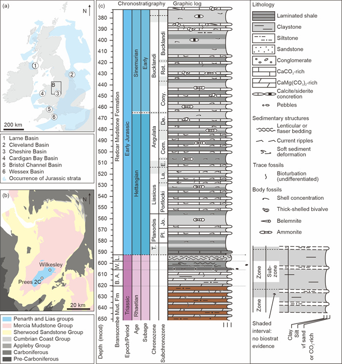
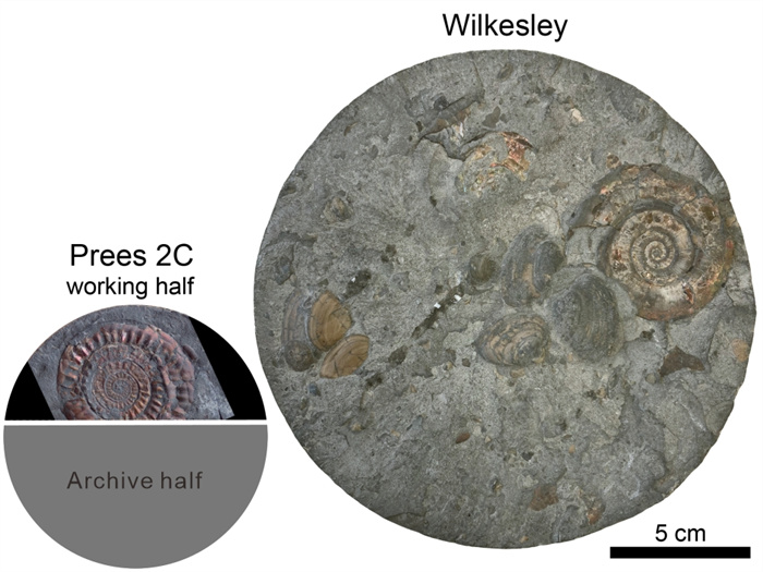
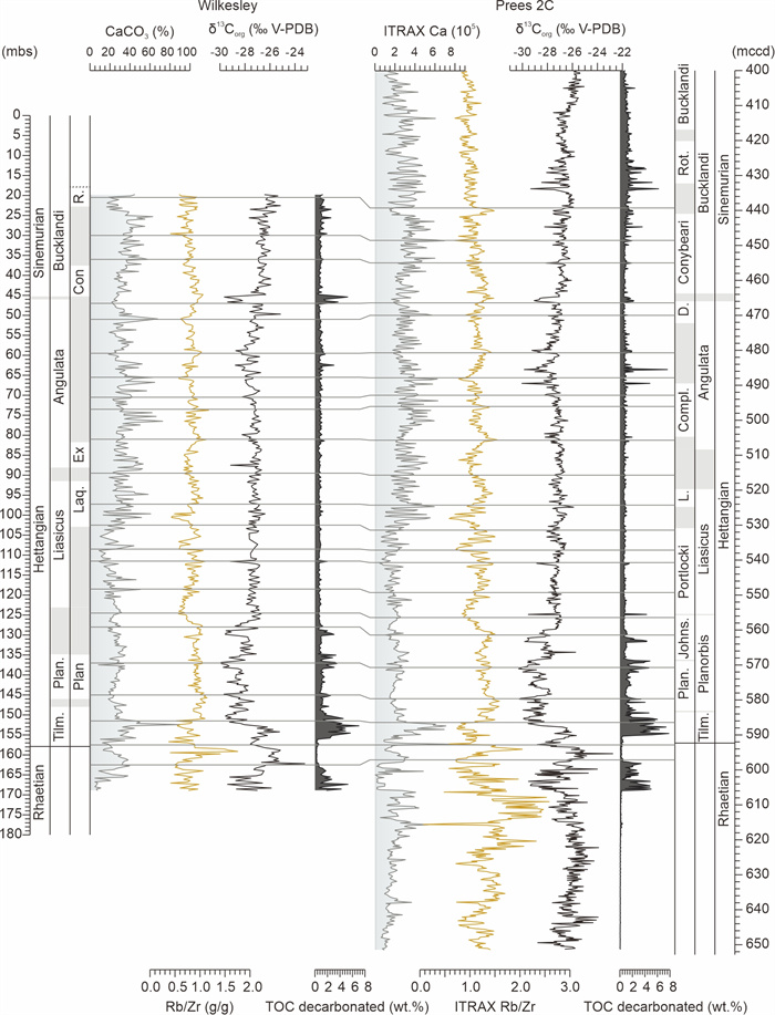
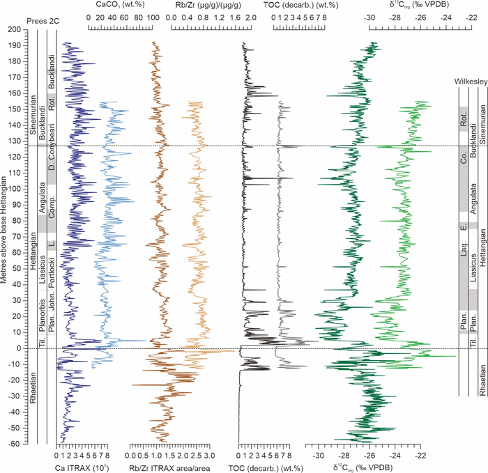
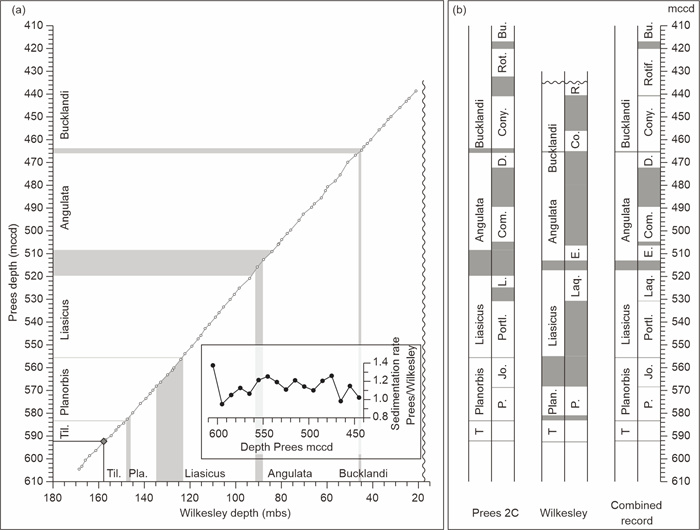
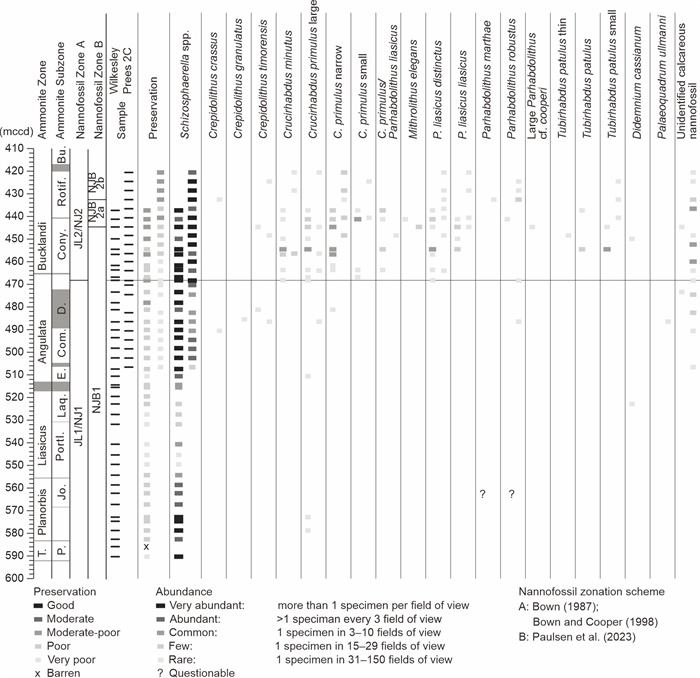
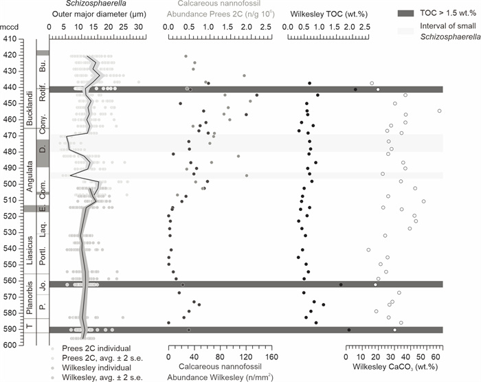
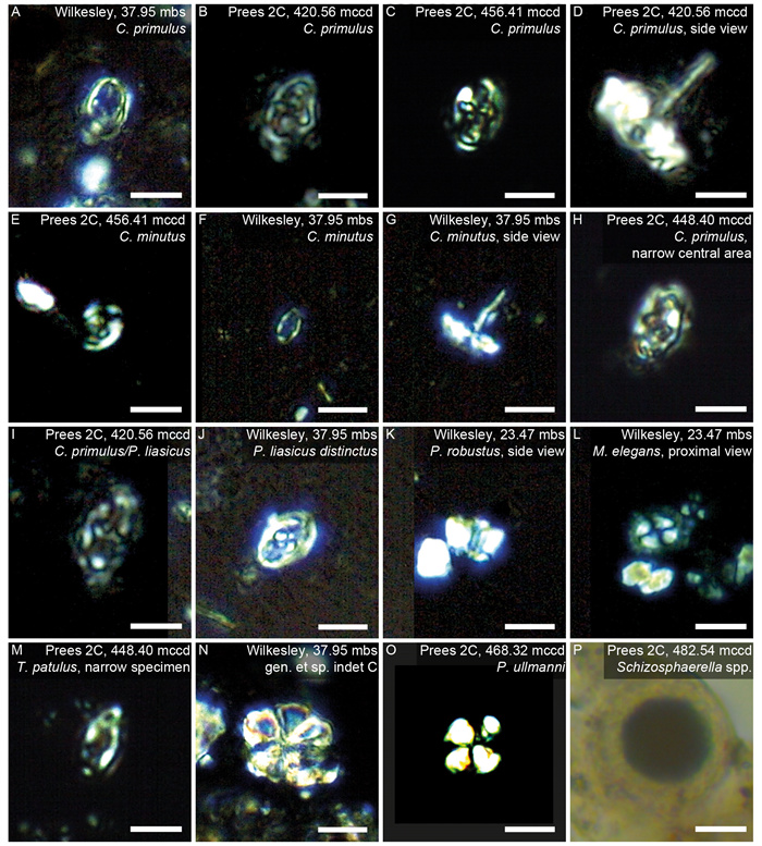
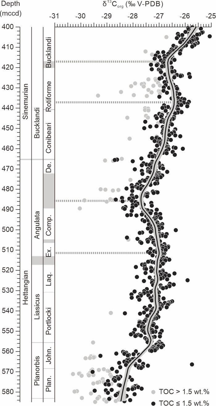
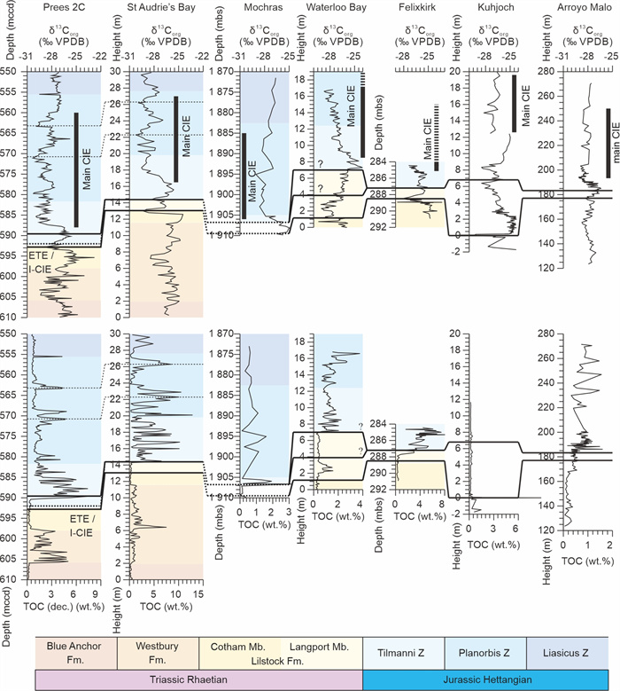
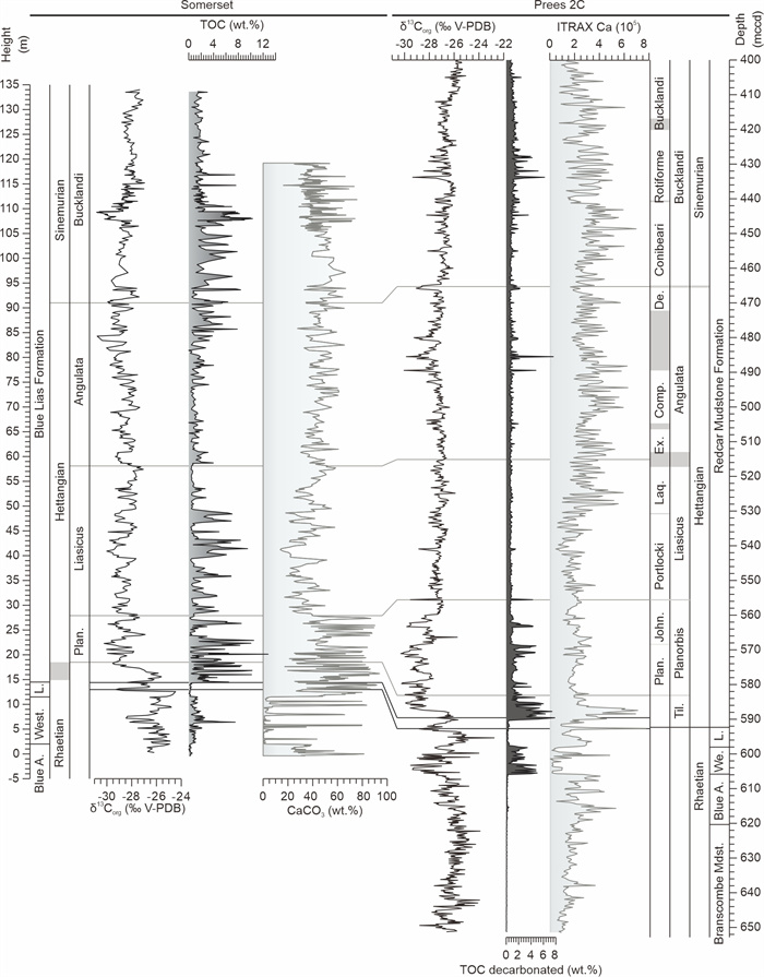
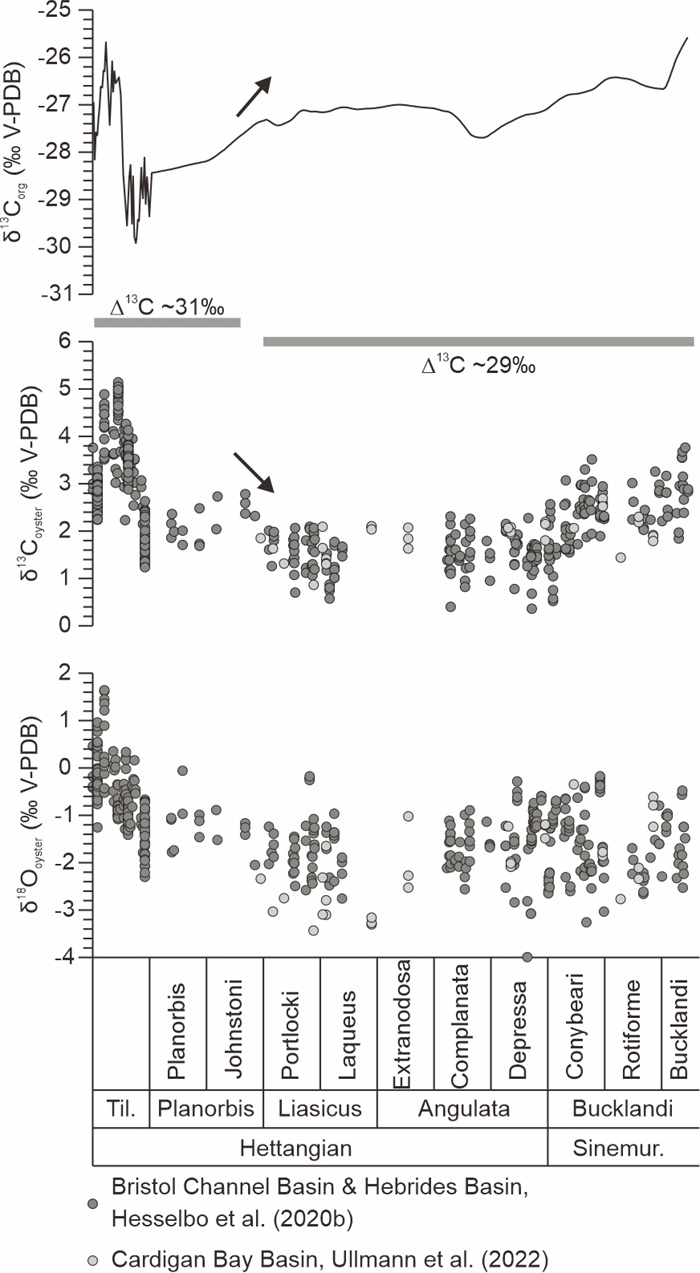
Highly resolved Earth System reconstructions of the Earliest Jurassic are hampered by complexities of existing reference sections. Here, an integrated stratigraphy of two core records is constructed, representing the expanded Hettangian sequence of the Cheshire Basin, UK. The combined record is based on ammonite and calcareous nannofossil biostratigraphy, organic carbon isotope ratios, and bulk rock chemical properties of legacy core material (Wilkesley) and Prees 2C, cored in 2020. Combination of ammonite records of these cores allows for substantial reductions in the uncertainties of ammonite zonal and subzonal boundaries. The new organic carbon isotope chemostratigraphy for the Hettangian of the Cheshire Basin improves temporal resolution compared to other published records, in particular for the Tilmanni and Planorbis zones. The limited occurrence of organic matter enrichment intervals associated with negative organic carbon isotope spikes in the Cheshire Basin allows for the identification of minor drifts throughout the Hettangian and into the Sinemurian which are likely of global significance. Organic carbon and macrofossil carbonate carbon isotope ratios largely follow the same trends in the Hettangian, but exhibit contrasting changes in the early Liasicus Zone, commensurate with a decrease in the isotopic difference of both records of ca. 2‰.
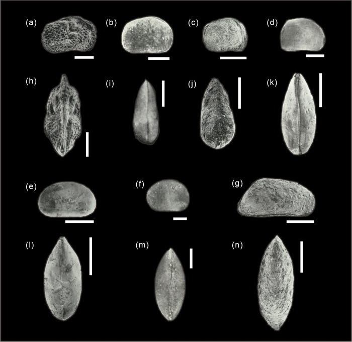
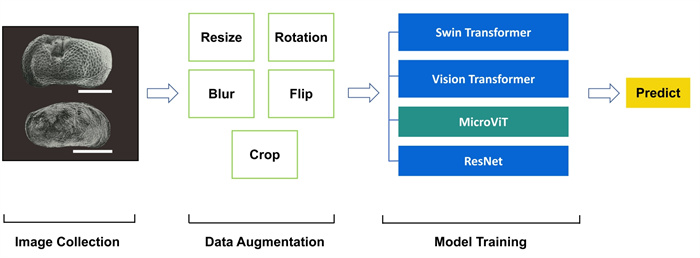
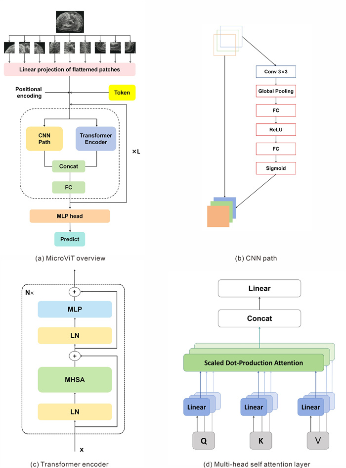
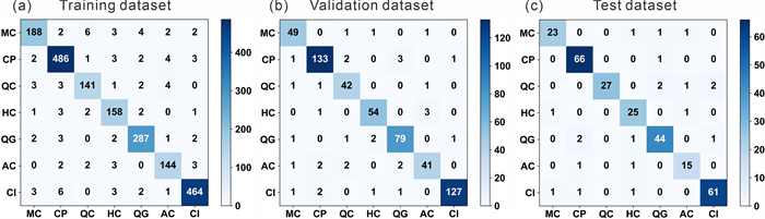
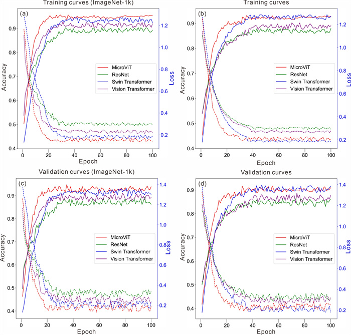
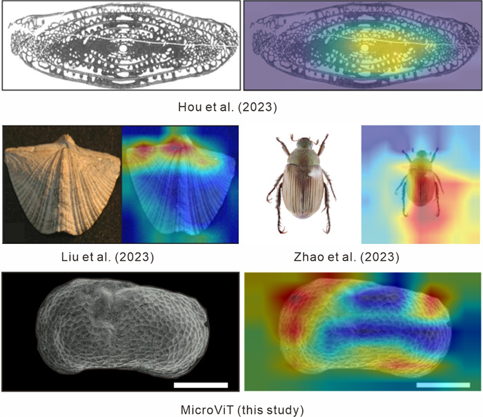
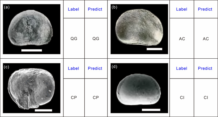
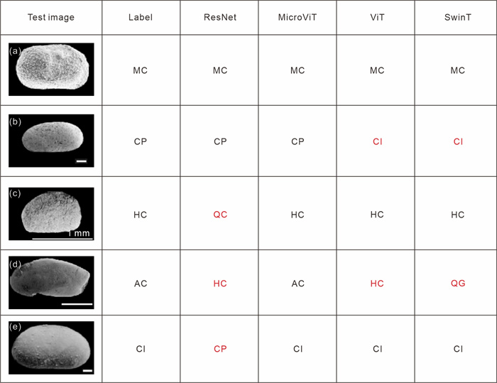
Microfossils play a crucial role in biostratigraphy and paleoenvironmental reconstructions, as the first appearance datum (FAD) and last appearance datum (LAD) of specific microfossils enable precise stratigraphic correlations and age determinations. However, traditional identification methods are often time-intensive and heavily dependent on expert knowledge. To overcome these limitations, we propose a dual-path deep learning model, MicroViT, which integrates convolutional neural networks (CNNs) and vision transformers (ViTs) to automate the identification of Cenozoic ostracods (

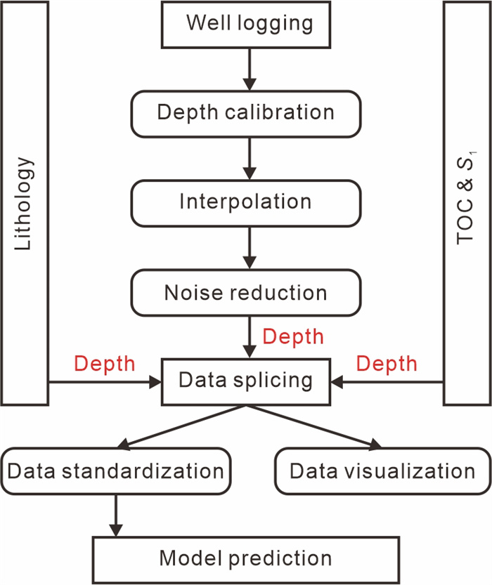
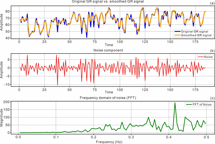
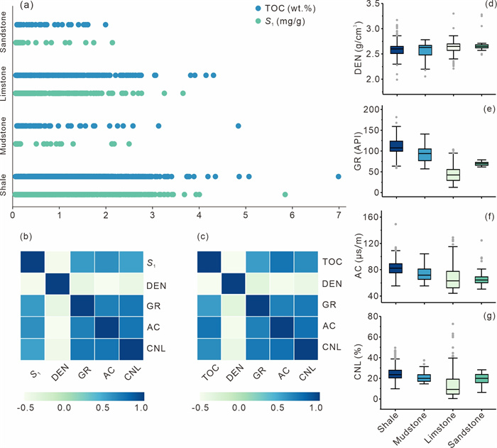
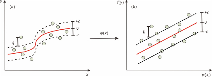
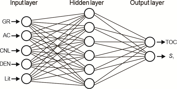
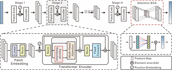
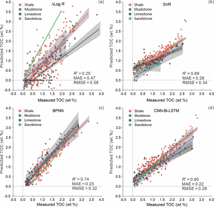
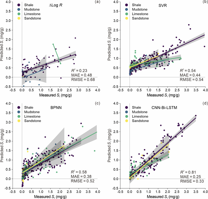
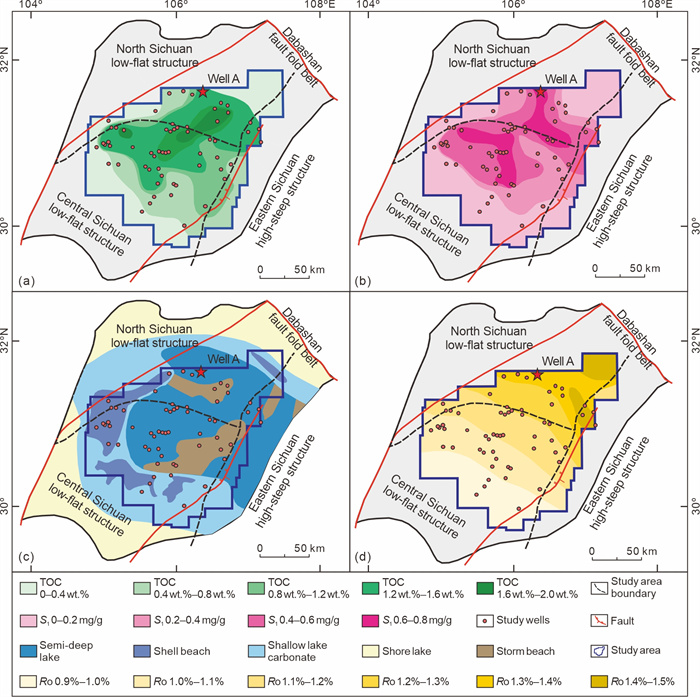
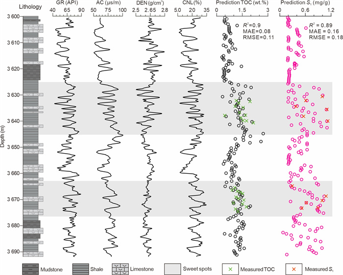
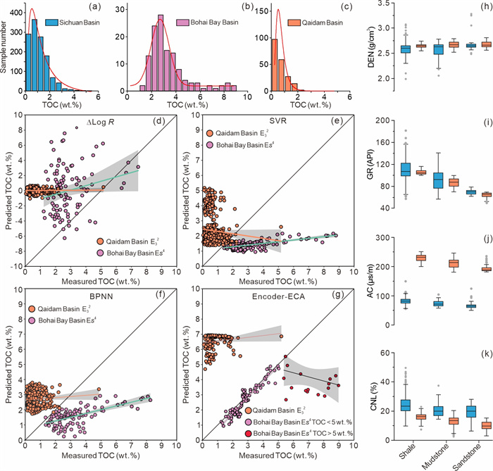
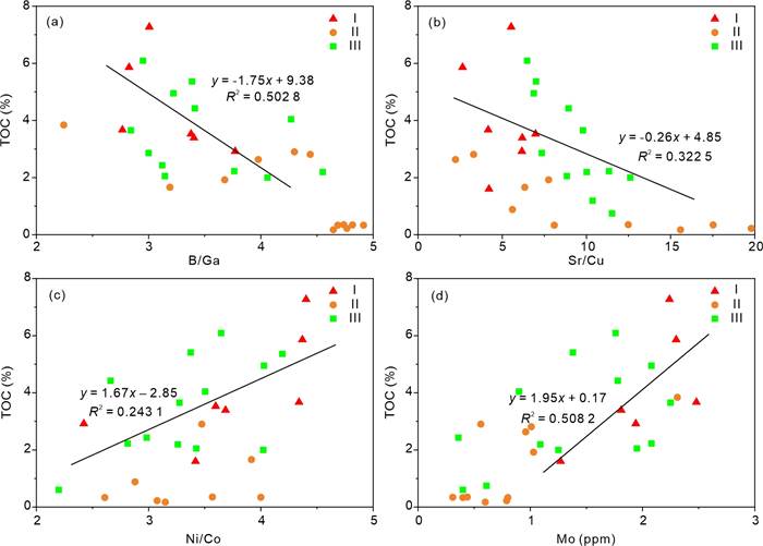
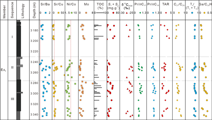
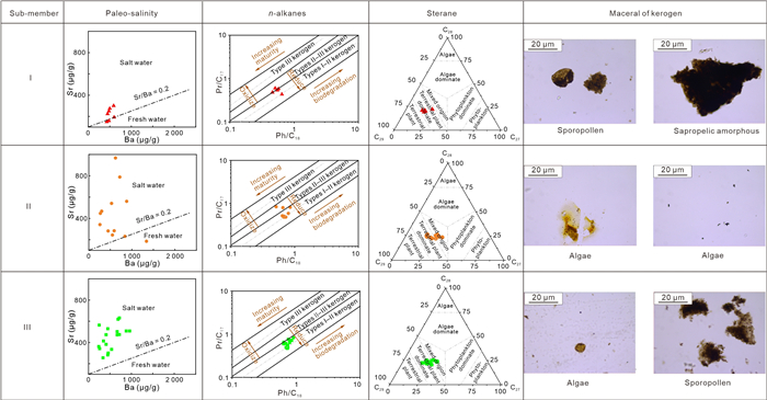
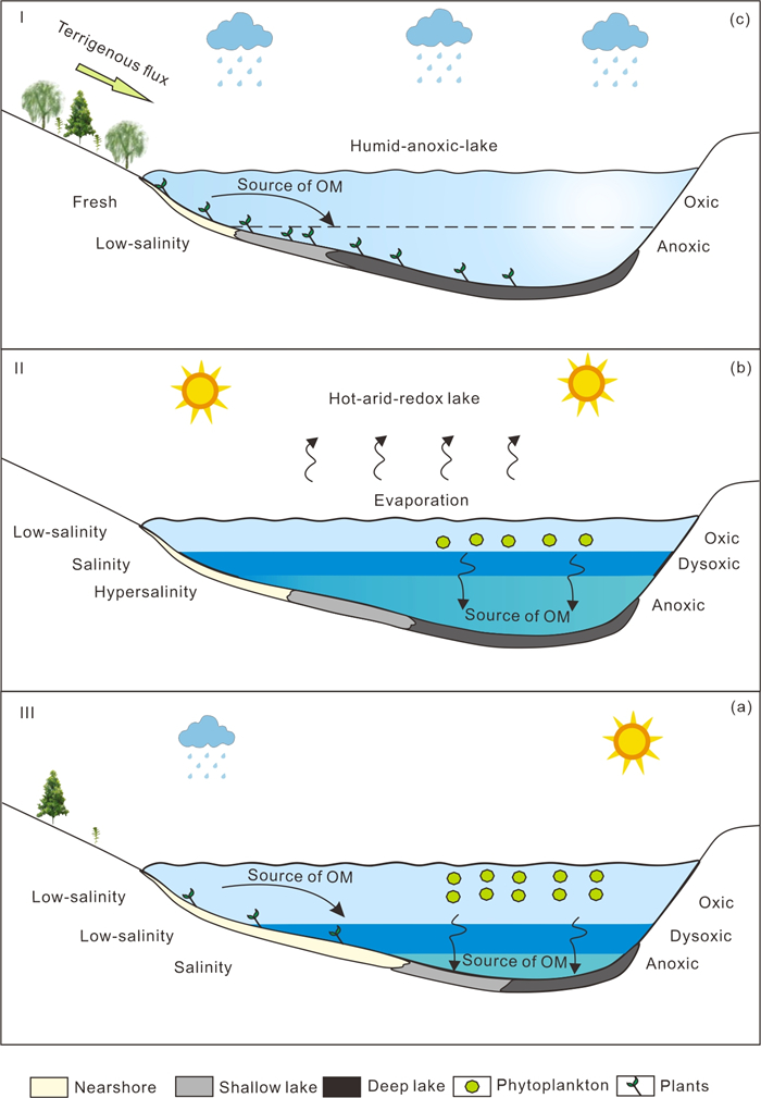
As an essential unconventional oil and gas resource, shale oil is of great significance to energy replacement and socio-economic development. Total organic carbon (TOC) and pyrolyzed hydrocarbon (
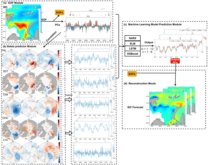
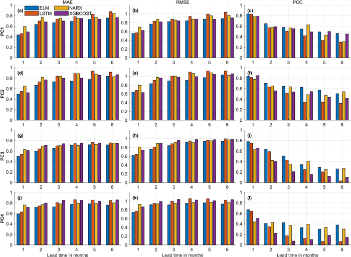
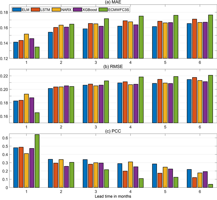
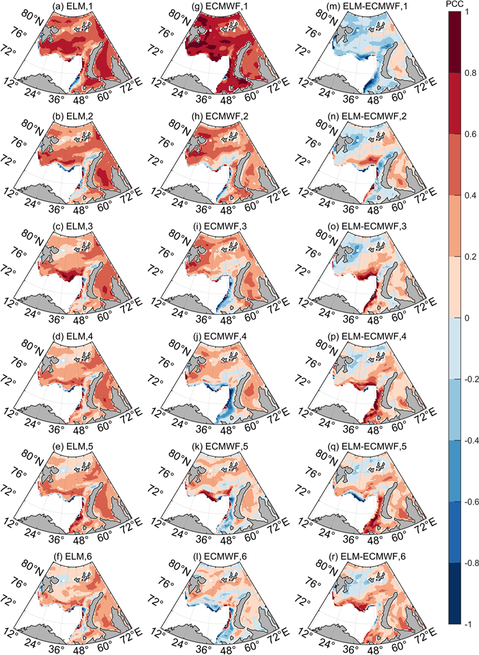
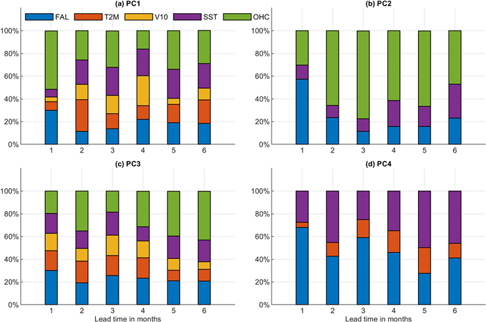
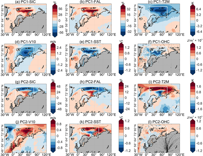
Variations of sea ice in the Barents-Kara seas attracts global attention because of its both local and remote climate impacts. The accurate prediction of Barents-Kara Seas sea ice concentration anomalies (BKSICA) is critically important for science and economics. This study employs four machine learning (ML) models, including extreme learning machine (ELM), nonlinear autoregressive exogenous model (NARX), long short-term memory (LSTM), and extreme gradient boosting (XGBoost), combined with empirical orthogonal function (EOF) methods to predict seasonal BKSICA. The ML models are trained based on the 1979–2014 oceanic and meteorological data, and are then used to predict the BKSICA for 2015–2022. Results indicate that the ML models provide reliable prediction up to 6 months, achieving a PCC over 0.6. Such prediction skill outperforms the state-of-the-art dynamical model at 2–6 months' prediction, although it is slightly less accurate at 1 month lead time. Among them, the ELM exhibits the optimal performance, attaining a regional average Pearson correlation coefficient (PCC) of 0.18 higher than the ECMWF at a 6-month lead time. The physical interpretability of the ML models is also analyzed, showing that subsurface ocean heat content anomalies to be a critical new predictor for BKSICA. These results highlight the effectiveness of the ML models in seasonal sea ice prediction.
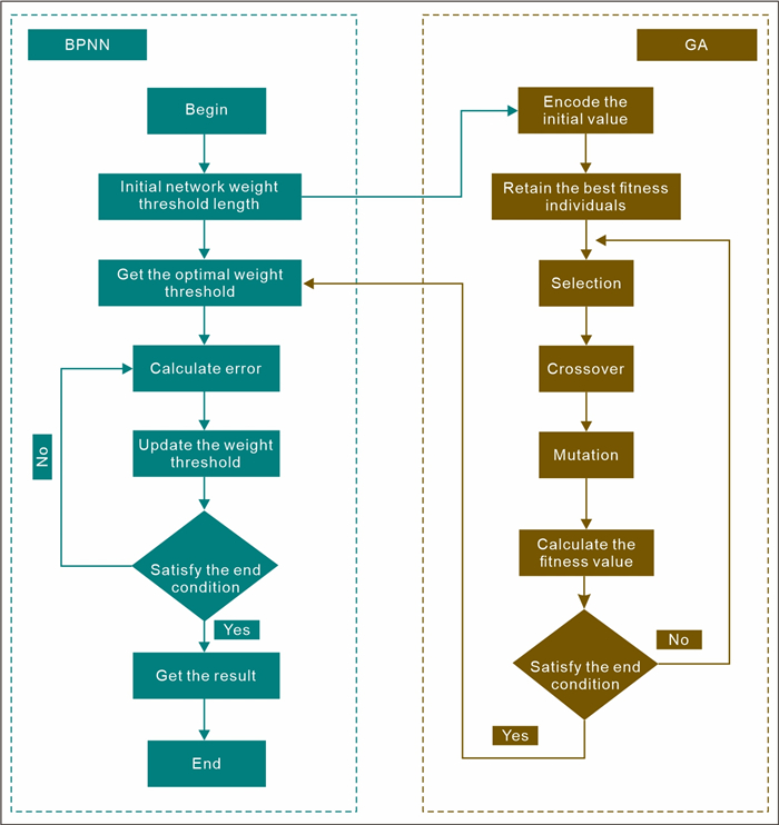
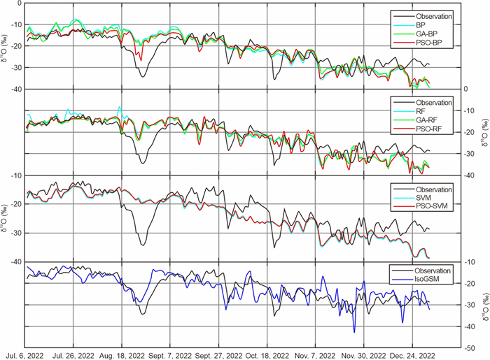
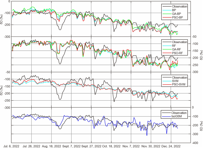
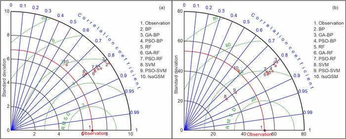
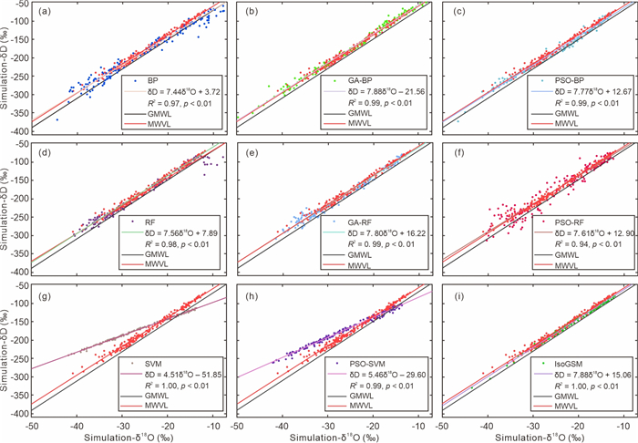
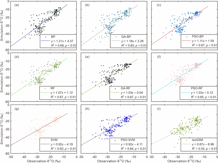
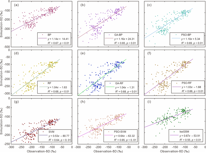
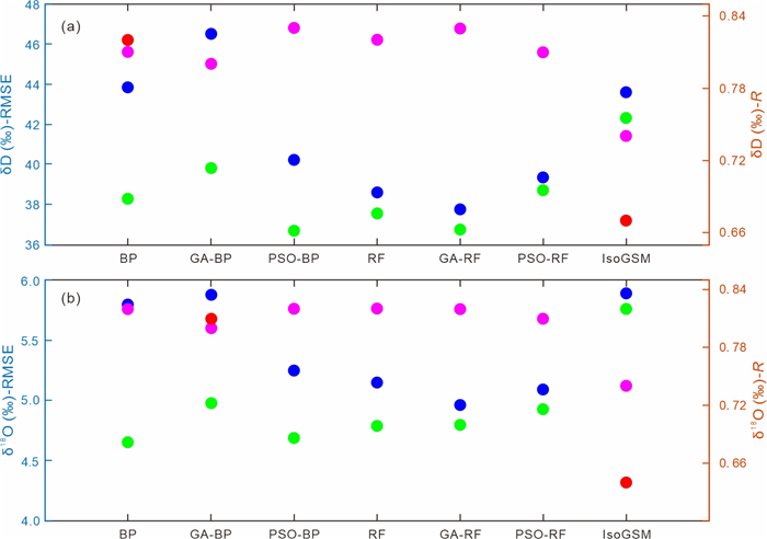
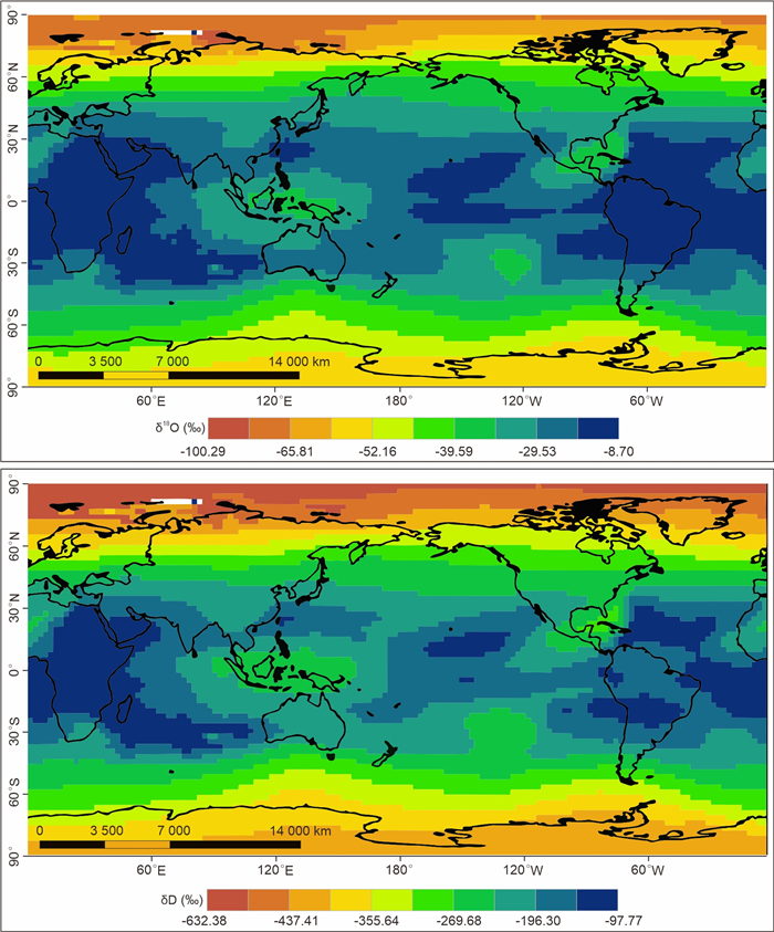
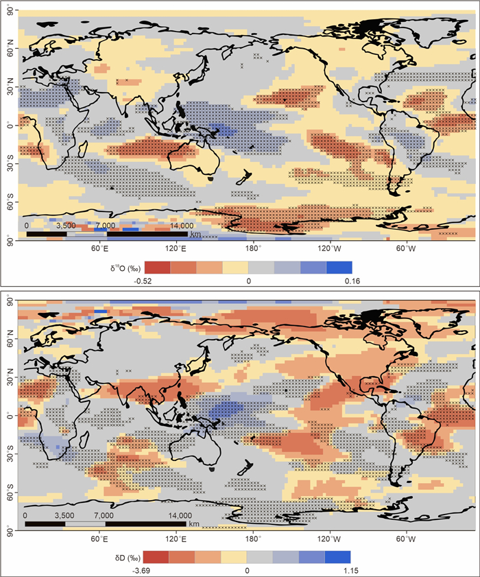
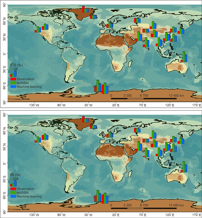
Atmospheric water vapor stable isotopes (δ18O and δD) are an important proxy to track the water cycle, changes of historical temperature and humidity, and characterize the monsoon intensity. Isotope general circulation models (iGCMs) are the main method for water vapor stable isotopes (Vaporiso) simulation, but the simulations from iGCMs are difficult to investigate Vaporiso dynamics at meso and sub-mesoscales due to the low spatial resolution and uncertainties of parameterization. Here, we present how machine learning can be a powerful tool in representing changes of daily Vaporiso, combined with the high-resolution Vaporiso observed at Muztagh Ata, western Tibetan Plateau (TP), from January 2022 to February 2023, where is dominated by the Westerlies. Different machine learning methods (random forest, BP neural network, support vector machine) and different parameter optimization schemes (genetic algorithm, particle swarm optimization) are used to represent the Vaporiso and corresponding meteorological conditions. We also compared simulations from machine learning and IsoGSM with the observed Vaporiso. The root-mean-square error (RMSE) of δ18O and δD simulated by machine learning is smaller than IsoGSM, and the correlation coefficient (
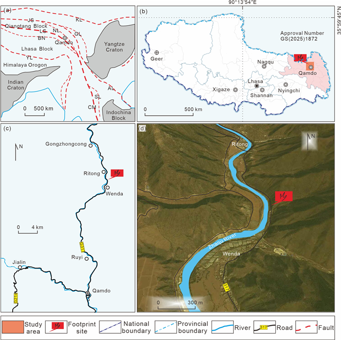
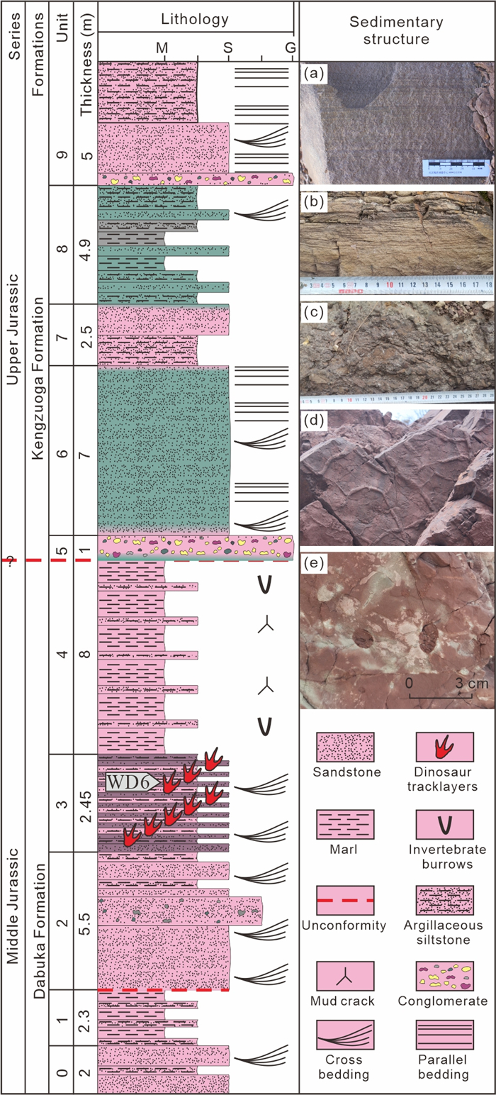
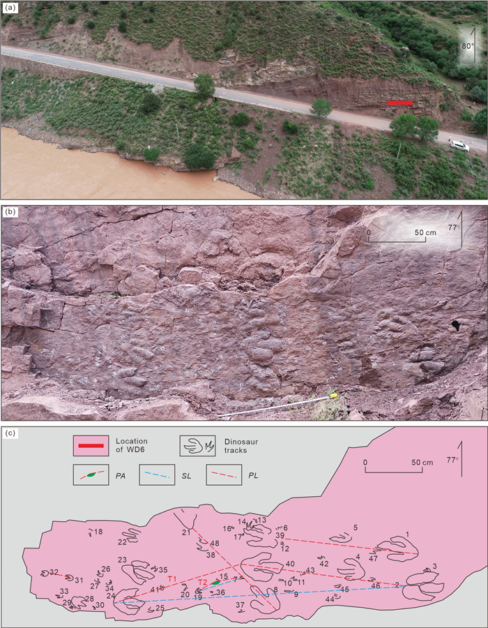
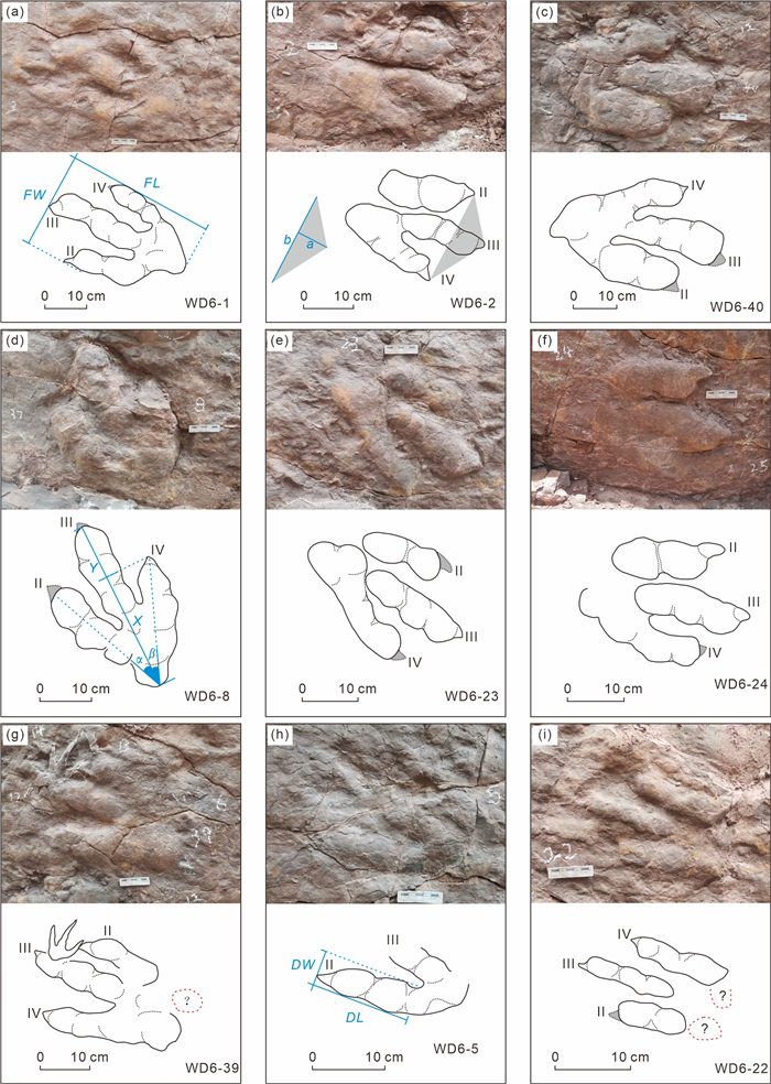
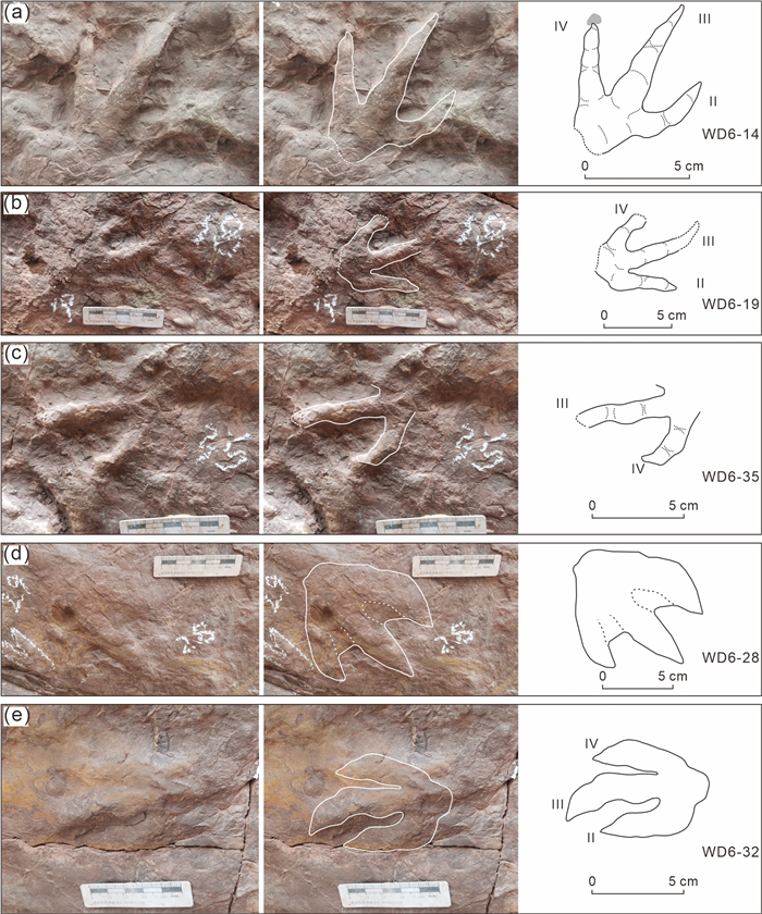
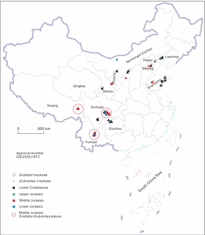
At the Middle Jurassic Wenda tracksite, in eastern Tibet, at least eight surfaces bearing dinosaur footprints are exposed. One of them, the WD6 track-bearing surface, shows the highest density of tracks, with forty-eight tridactyl tracks. They are assigned to
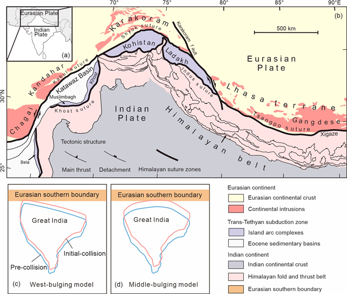
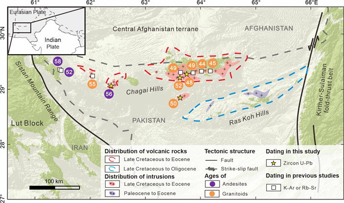
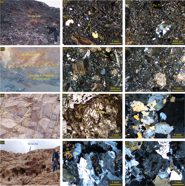
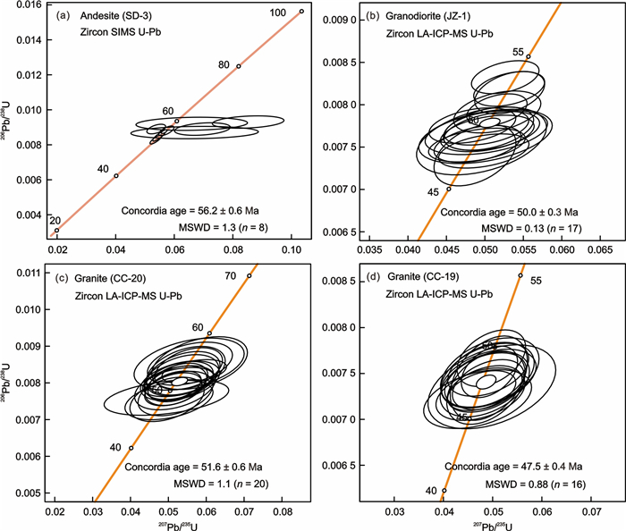
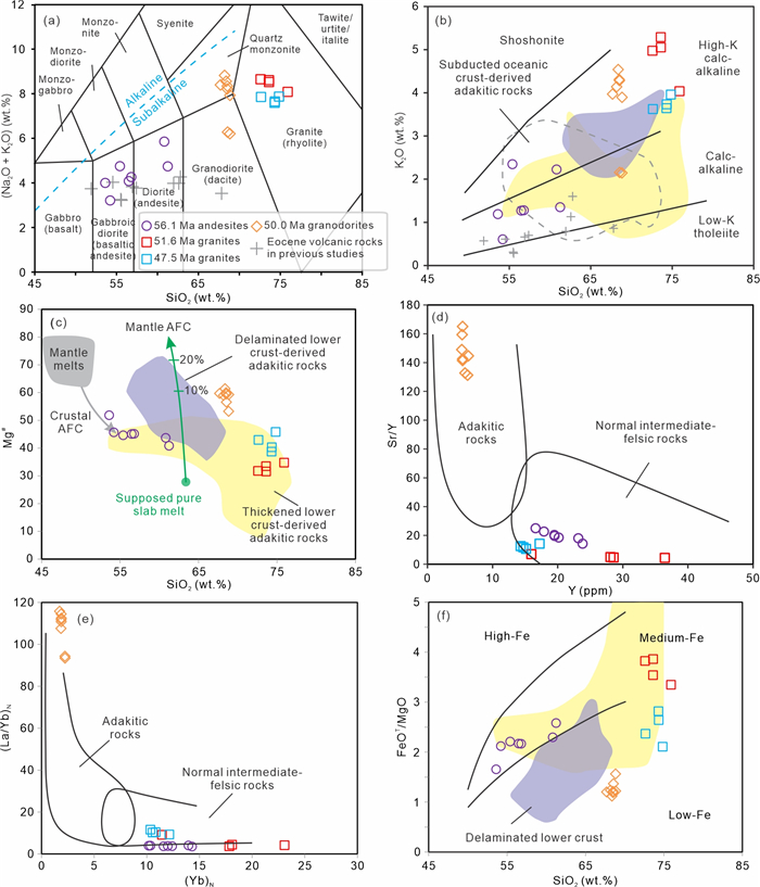
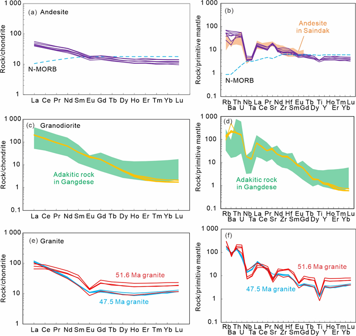
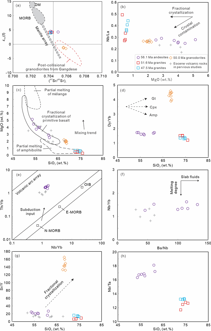
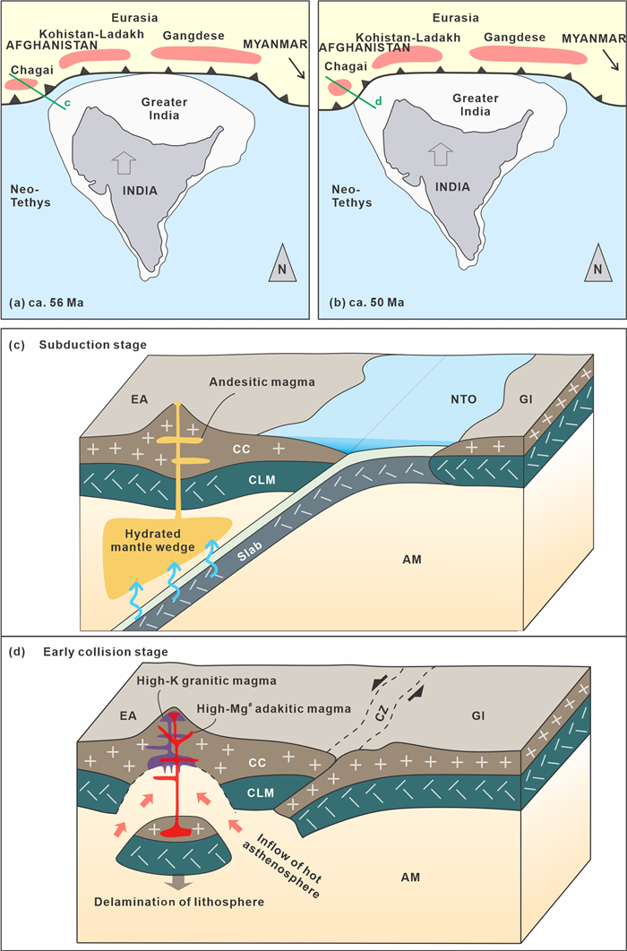
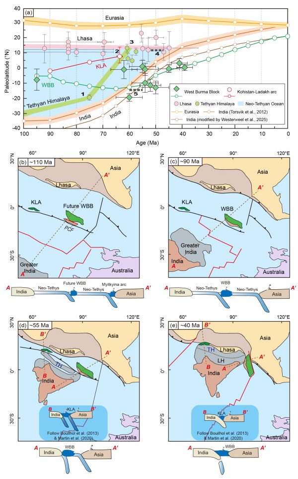
The pattern of India-Eurasia collision is critical for understanding plateau uplift and Cenozoic global climate change. However, the initial collisional timing and location remain debated. This study investigates magmatic rocks from the Chagai Hills in the western India-Eurasia collision zone, integrating petrological, geochronological and geochemical analyses of andesites (56.2 Ma), granodiorites (50.0 Ma) and granites (51.6–47.5 Ma). The arc-like andesites with depleted Nb-Ta-Ti, low 87Sr/86Sr of 0.704 2–0.705 1 and high
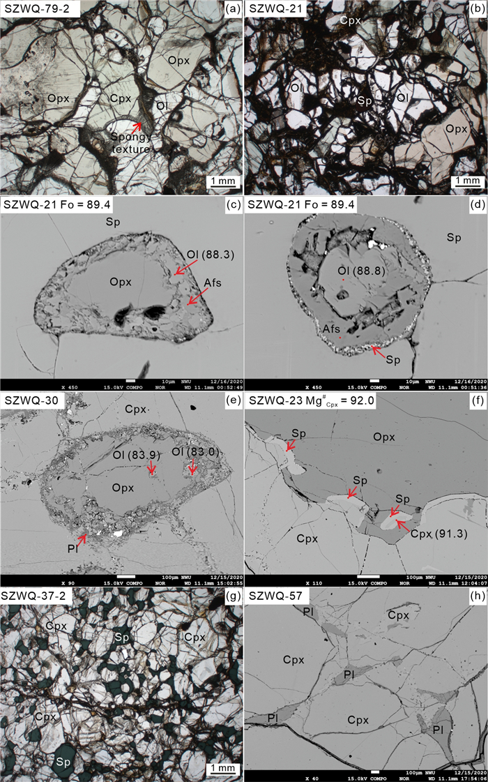
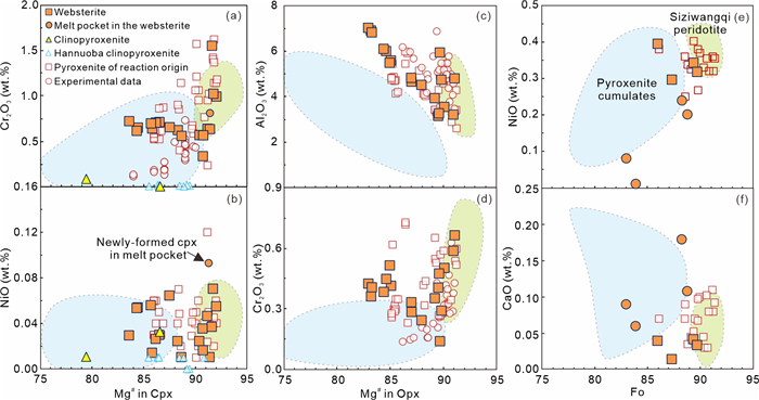
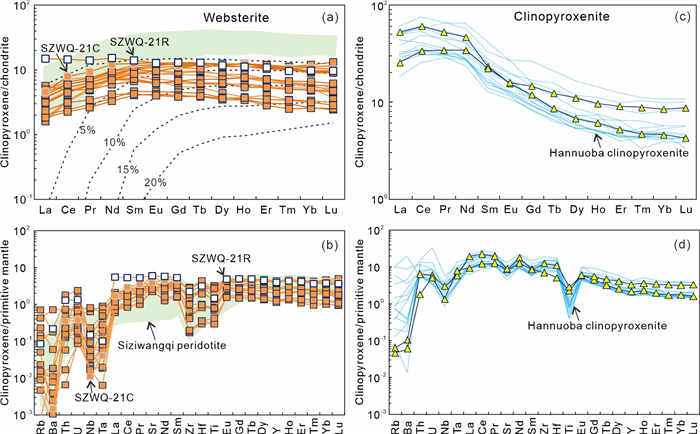
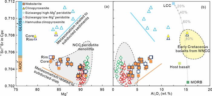
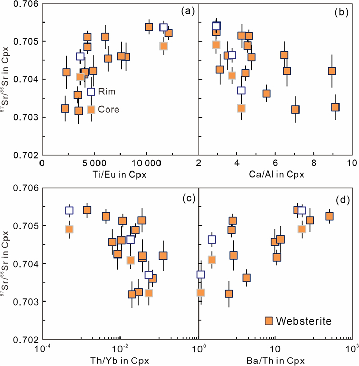
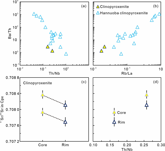
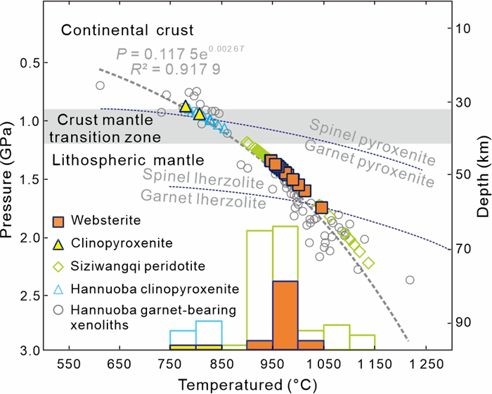
The North China Craton (NCC) has experienced significant lithospheric modification due to multiple subduction events. This study investigates the petrogenesis and geochemical characteristics of two types of pyroxenite xenoliths hosted in the Siziwangqi (Siziwang Banner) Cenozoic basalts in the northwestern NCC. The websterites exhibit reaction textures and mineral compositions indicative of peridotite-melt interaction, with formation depths comparable to those of Siziwangqi peridotites. Clinopyroxenes in these websterites display high Ti/Eu ratios and low (La/Yb)N ratios, along with 87Sr/86Sr ratios ranging from 0.703 2 to 0.705 4. These features suggest metasomatism by hydrous silicate melts derived from the partial melting of altered Paleo-Asian oceanic crust. In contrast, the clinopyroxenites exhibit interstitial textures and convex-upward rare earth element (REE) patterns, consistent with low-pressure cumulates formed in the crust-mantle transition zone. Their parental magmas resemble Early Cretaceous basalts, likely originating from an enriched mantle source modified by subduction-related terrigenous sediments. Clinopyroxenes in these clinopyroxenites show radiogenic 87Sr/86Sr ratios (0.707 7–0.708 4), low Ti/Eu and high (La/Yb)N characteristics, which suggest the post-formation metasomatism by sediment-derived carbonatitic hydrous melts. The distinct geochemical signatures of the two pyroxenite types record the complex interaction between subducted materials and overlying lithosphere, emphasizing the significant role of subduction-related metasomatism in the lithospheric modification beneath the northwestern NCC.
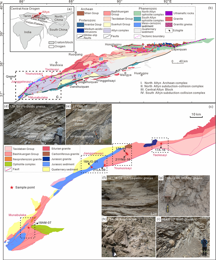
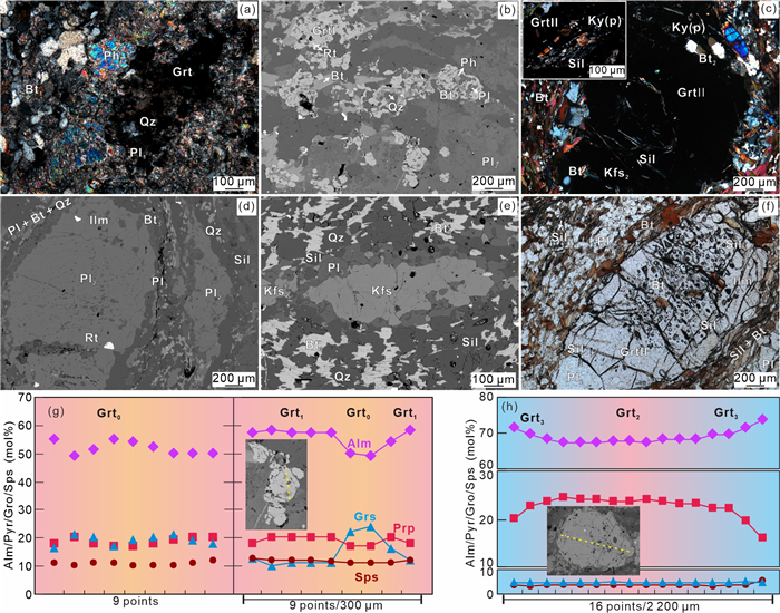
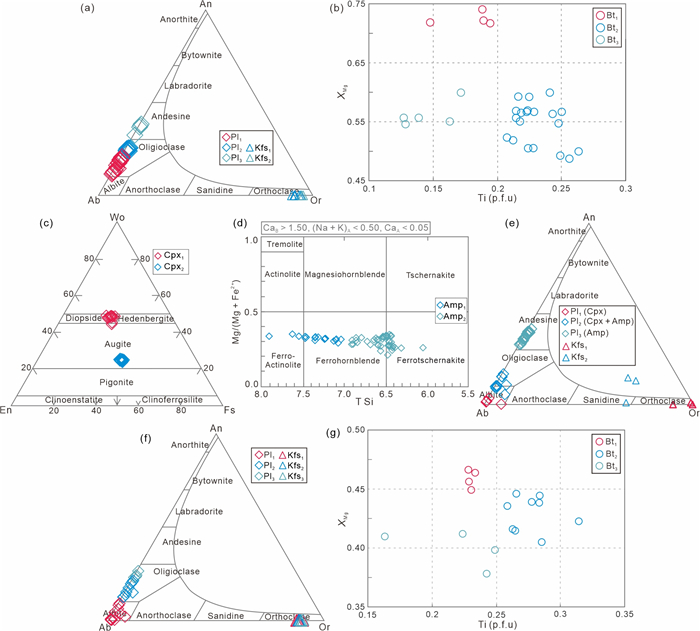
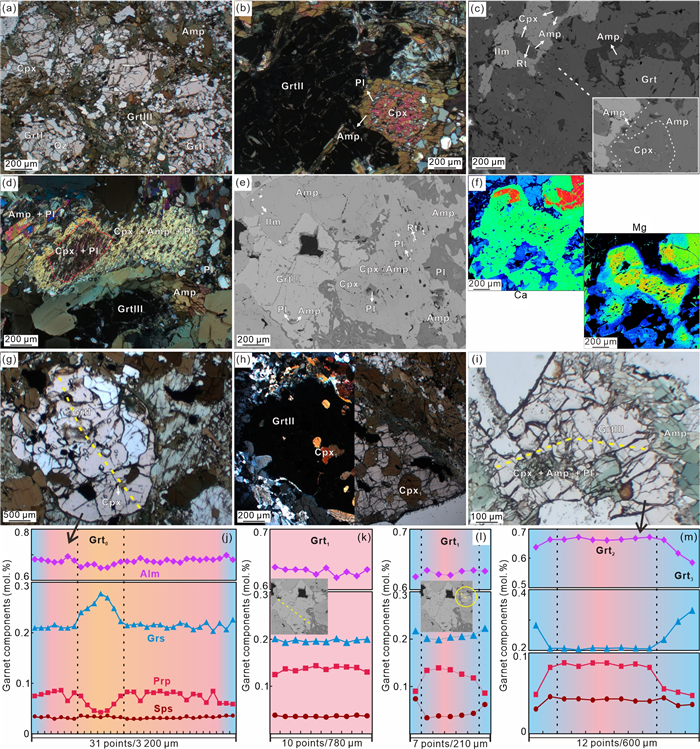
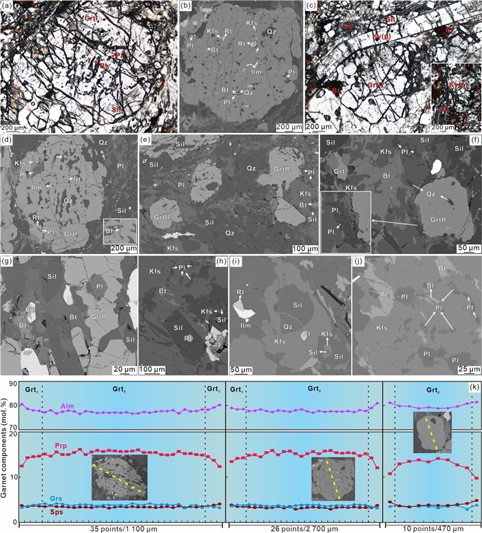
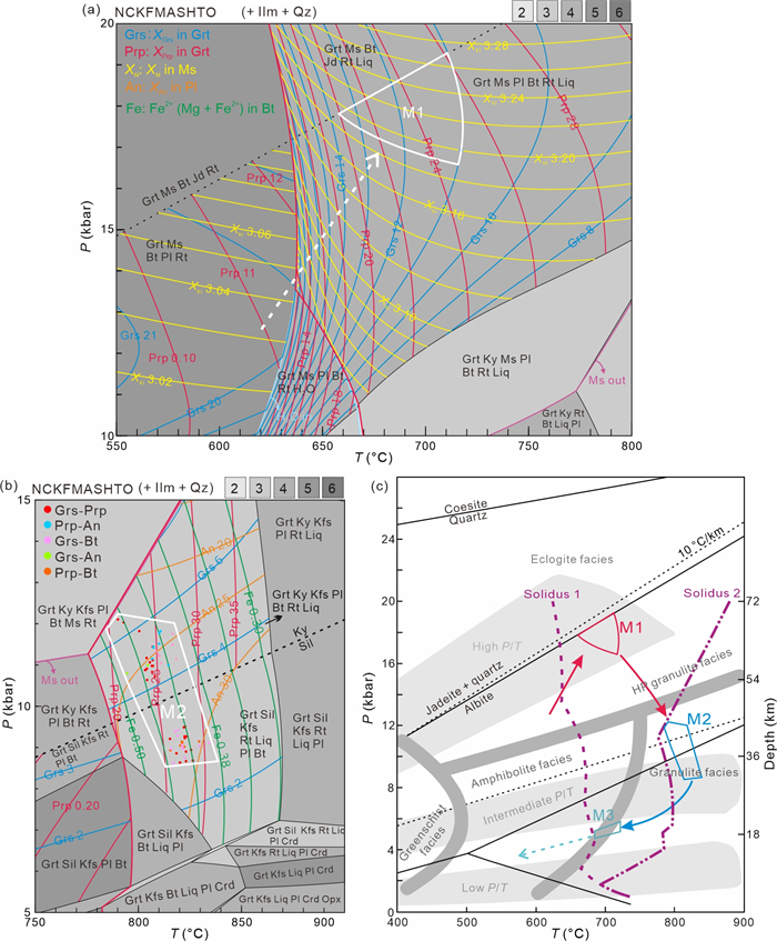
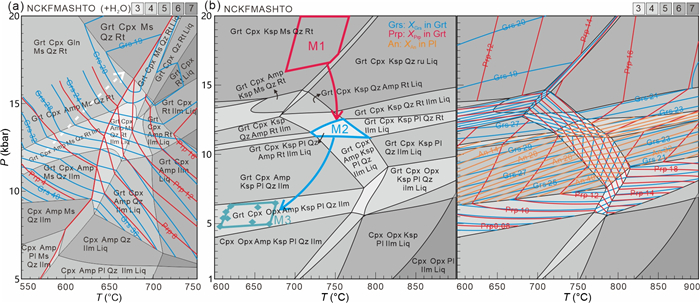
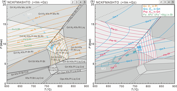
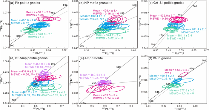
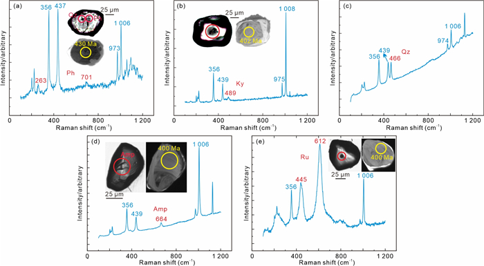
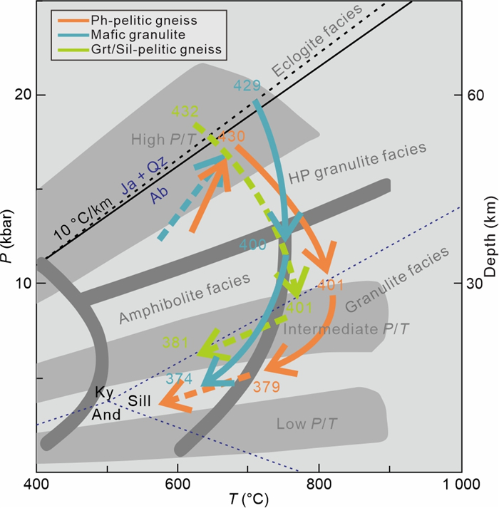
High-pressure metamorphic rock belts serve as critical markers for convergent lithospheric plate boundaries and are instrumental in correlating subduction-collision events across different tectonic units. In this study, we document the identification of medium-pressure to high-pressure (MP-HP) rocks along the south margin of the Central Altyn (SMCA), which constitute a Silurian metamorphic belt within the Proto-Tethyan Altyn Orogen. Detailed petrographic, mineralogical, phase equilibrium modeling, and zircon geochronological studies are presented to reconstruct the metamorphic evolution of the belt. The studied rocks preserve evidence of three distinct metamorphic stages: (1) HP peak metamorphism with
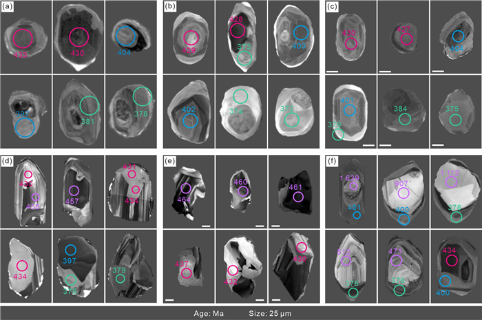
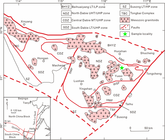
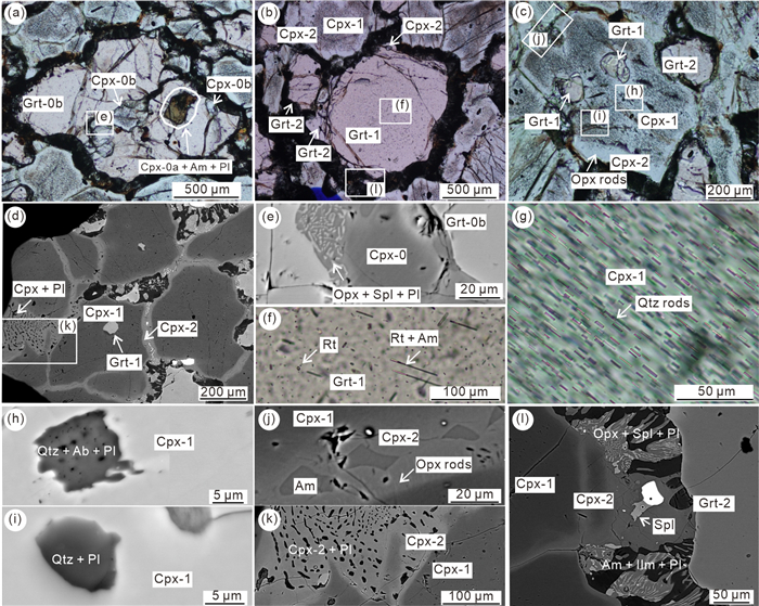
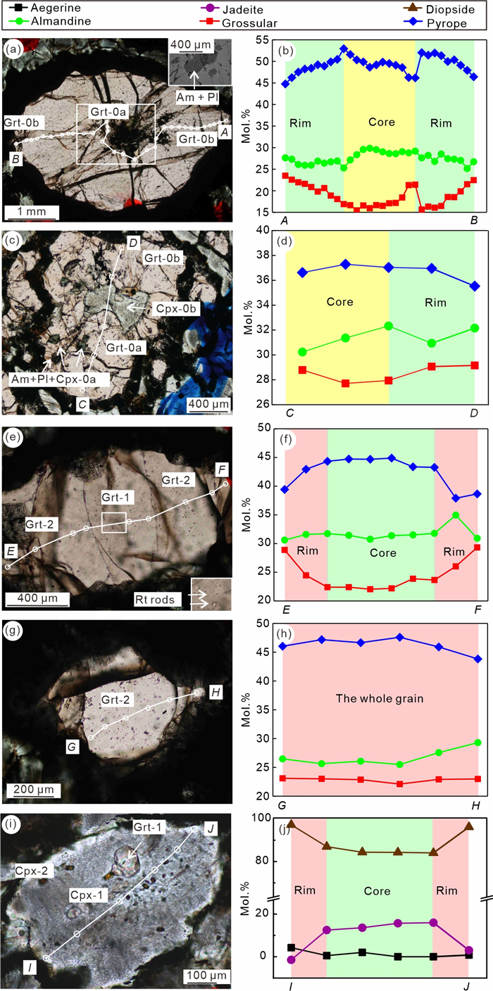
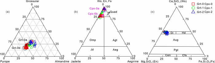
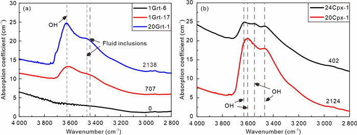
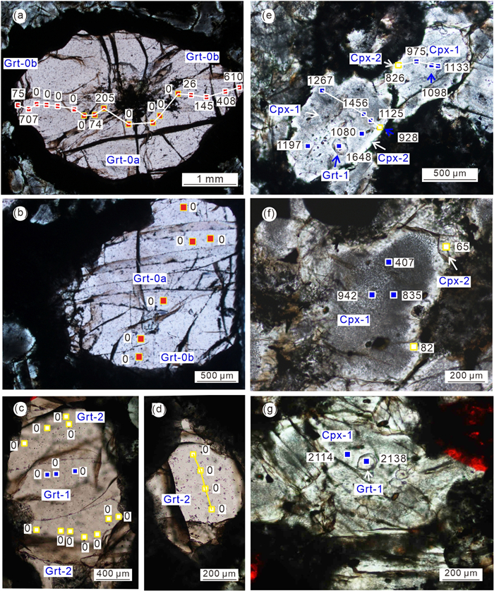
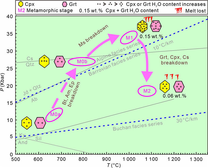
Subduction-driven water (H2O) cycling plays a fundamental role in Earth's geodynamics. However, the migration of H2O during continental slab exhumation is poorly constrained. This study investigates Triassic ultrahigh-pressure (UHP) garnet pyroxenites from the Dabie Orogen, China, to quantify H2O loss during hot exhumation (> 900 ℃). By integrating petrology, Fourier transform infrared spectroscopy (FTIR), and phase equilibrium modeling, we reconstructed the pressure-temperature (

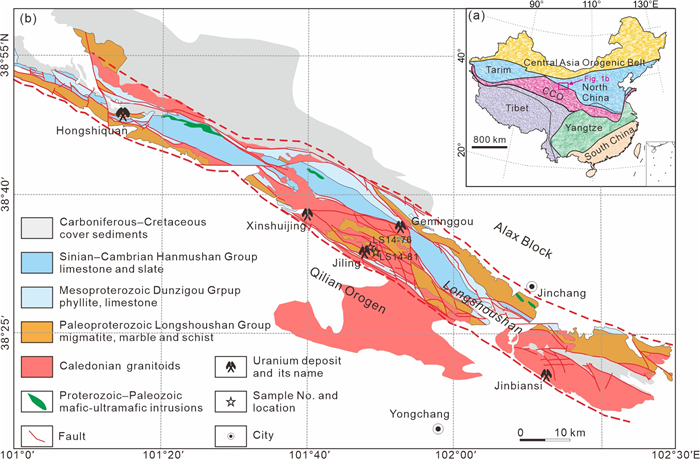
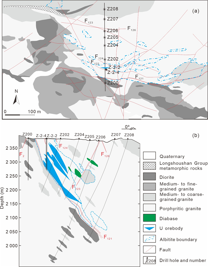
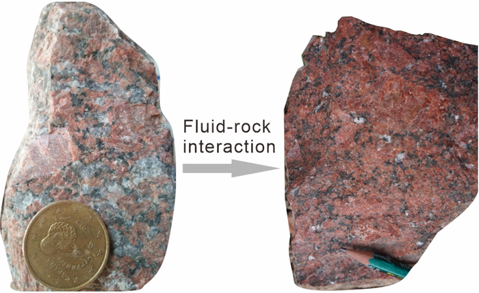
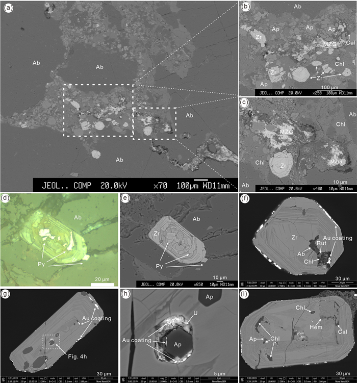
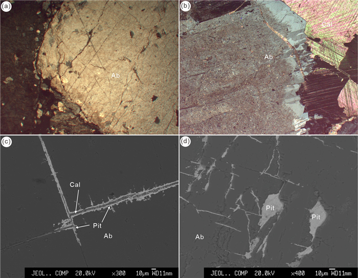
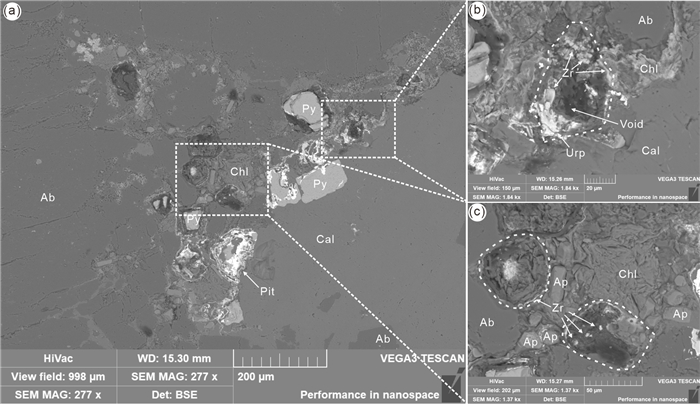
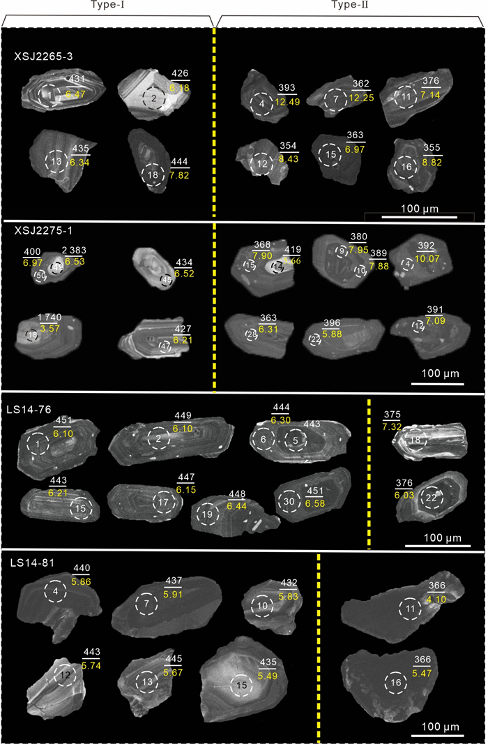
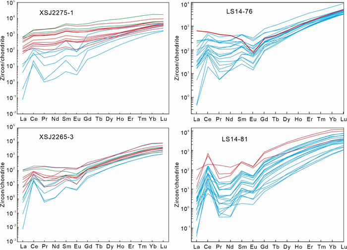
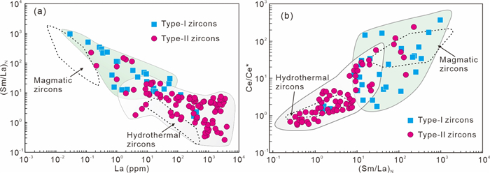
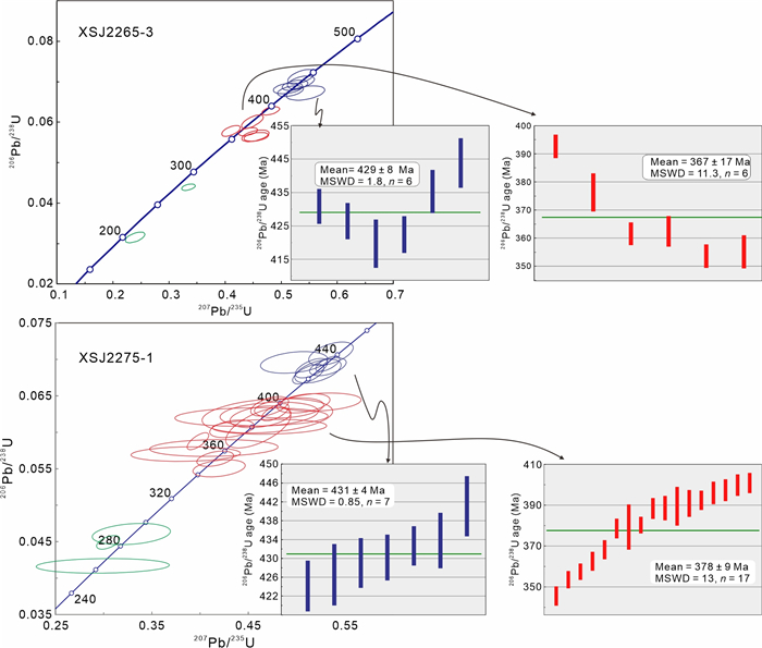
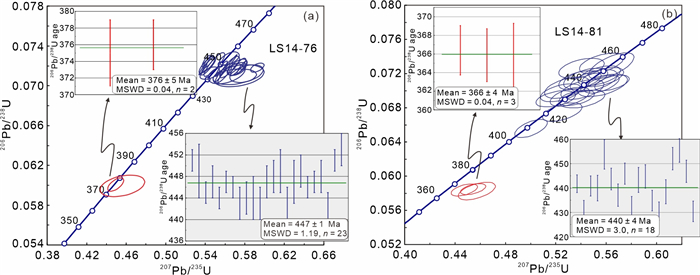
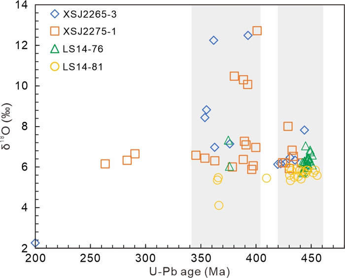
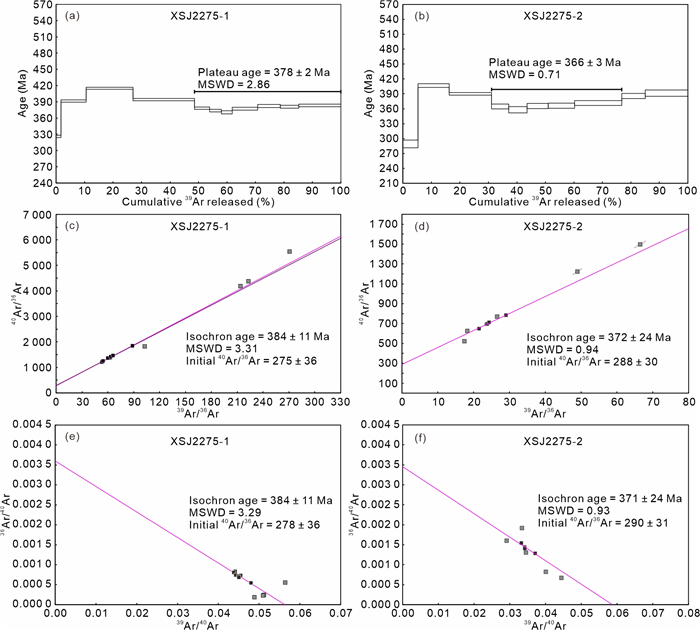
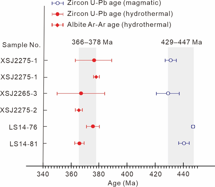
Na-metasomatite uranium deposits are an important type of large-tonnage low-grade uranium deposit. They are characterized by an intimate association between uranium minerals and albite, and by the common development of syn-ore hydrothermal zircons. Similar to other types of uranium deposits, constraining an accurate age of mineralization remains a challenge for the Na-metasomatite type ones. In this study, we present for the first time, an approach that combines age dating results from the syn-ore albites (40Ar-39Ar) and hydrothermal zircons (U-Pb) for a typical Na-metasomatite uranium deposit, the Xinshuijing deposit in the Longshoushan metallogenic belt of Northwest China. The hydrothermal zircon U-Pb and albite 40Ar-39Ar ages are consistent with each other (378‒366 Ma; within error), but also identical to the previously reported uraninite chemical U-Pb ages (approximately 370 Ma). The coupled application of hydrothermal zircon U-Pb and albite 40Ar-39Ar age dating is thus regarded as a robust approach for constraining the age of mineralization for Na-metasomatite uranium deposits. An age gap of approximately 70 Myr between uranium mineralization (~ 370 Ma) and host granitoid emplacement (about 440 Ma) suggests no direct genetic linkage between the two. Further exploration in the surrounding metamorphic units is therefore suggested, rather than only focusing on the host granitoids, especially where intensive wallrock alteration and structural features are pervasive. The varied hydrothermal zircon δ18O isotope compositions are attributed to the significant fluid-wallrock interaction during the uranium mineralization, which is consistent with our previous fluid inclusion and geochemical studies. Our study highlights the importance of selecting appropriate isotopic dating methods, which is informed by detailed paragenetic and geochemical analysis of dateable minerals formed before or coeval to the main-stage uranium mineralization. Moreover, it is underlined that the exact ore-forming age determination is of great significance since it sheds light on the ore genesis and provides valid constraints on the ore-controlling factors during further exploration.
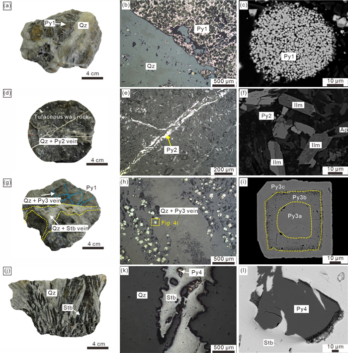
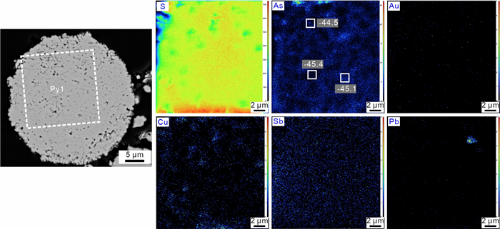
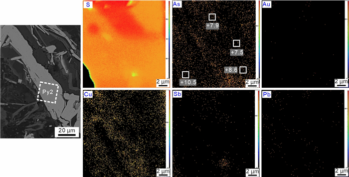
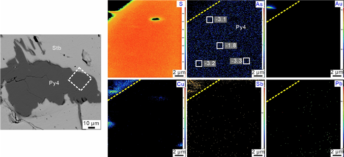
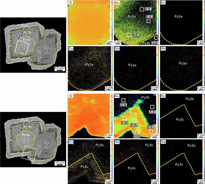
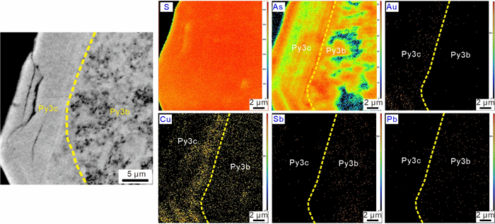
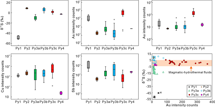
Gold (Au) and antimony (Sb) are two critical metals that commonly co-occur in sedimentary rock-hosted deposits. However, the genetic relationship between Au and Sb mineralization remains unclear. The Youjiang Basin, located in the low-temperature metallogenic domain of South China, hosts many important Au-Sb deposits. Among these, the Qinglong Deposit stands out as the largest vein-type Sb deposit in the basin, with approximately 300 kilotons of Sb and extensive Au mineralization. In this study, novel data from Nano-SIMS elemental mapping and sulfur isotopic analysis on paragenetically-constrained pyrite from Qinglong are provided, aiming to better understand the origin of reduced sulfur in the Au and Sb mineralization stages, as well as the genetic mechanism of Au and Sb mineralization. Four types of pyrite were identified at Qinglong based on microtextural observations and chemical features. Framboidal pyrite (Py1) and columnar pyrite (Py2) are mainly identified from the least-altered host rocks, contain no Au and Sb, and display largely negative δ34S values (-52.1‰– -44.5‰) and positive δ34S values (7.5‰–10.5‰), respectively, suggesting they formed during sedimentary and diagenetic stages. Zoned pyrite (Py3), which only occurs in hydrothermal mineralized samples, exhibits core (Py3a)-mantle (Py3b)-rim (Py3c) textures. Py3b contains elevated Sb and Pb but no Au, and has high δ34S values (-0.5‰–10.4‰), recording a possible episode of hydrothermal fluids that predated Au mineralization. Additionally, the alteration and recrystallization of Py1 by this episode of fluids led to the formation of Py3a. Py3c contains high As and Au contents, and shows most δ34S values between -1‰ and 3.2‰, representing Au mineralization stage. The sharp boundaries, distinct trace elements, and different δ34S values between Py3b and Py3c suggest that they formed from two discrete hydrothermal events. Relatively homogeneous pyrite (Py4) is intergrown with stibnite and formed specifically during Sb mineralization stage. Both Py3c and Py4 display similar δ34S signatures consistent with magmatic sulfur. Based on these observations, we propose that ore-forming fluids of Au and Sb mineralization at Qinglong may be originated from same deep magmatic-hydrothermal system, and fluids evolution and precipitation mechanism were the key factors controlling their differentiation. Meanwhile, our study demonstrates that the high-resolution in situ sulfur isotopic and trace elemental analysis of pyrite can effectively discern ore-forming fluid events and elucidate the differentiation mechanism of ore-forming elements.
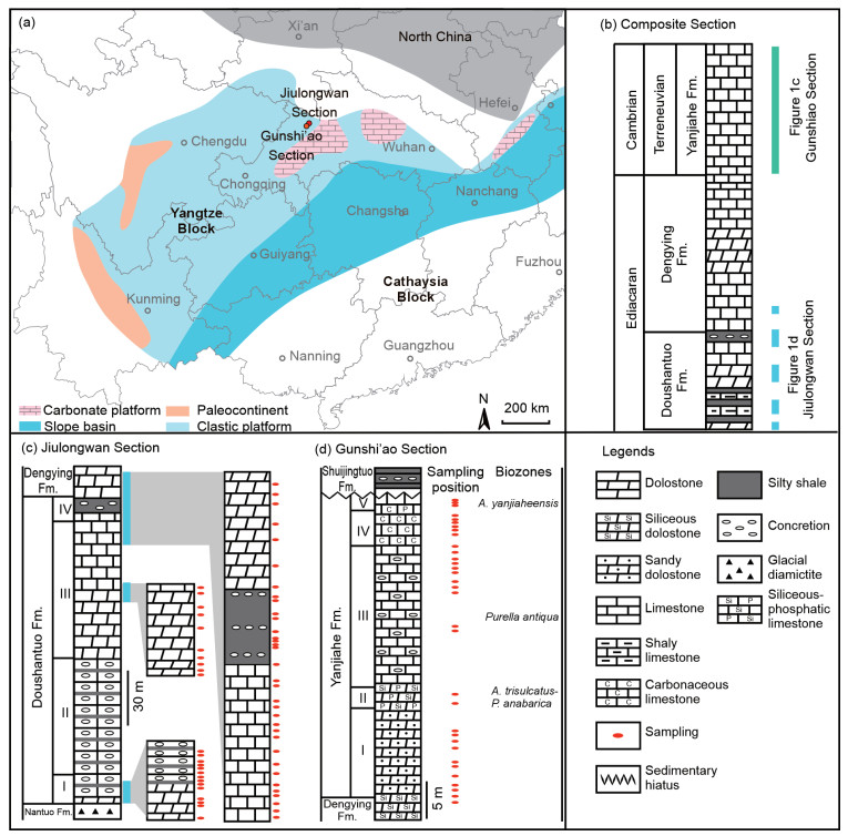
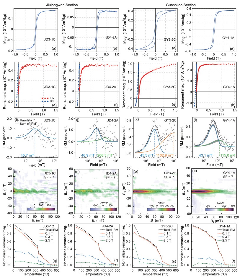
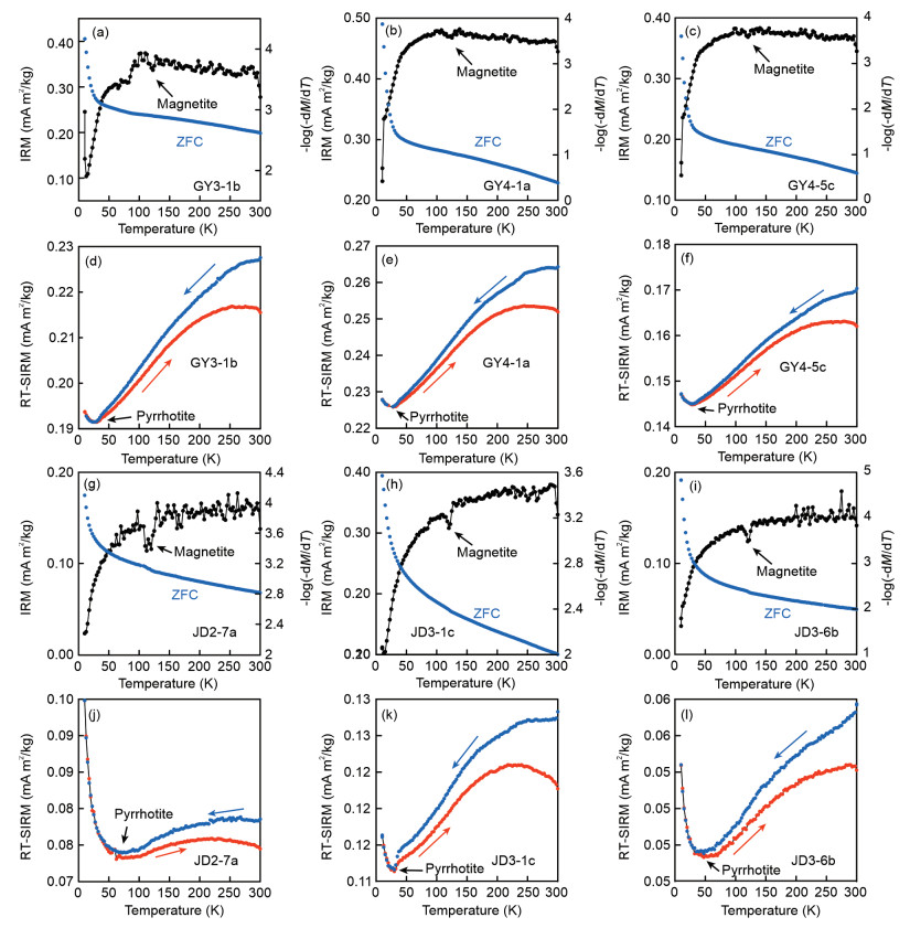
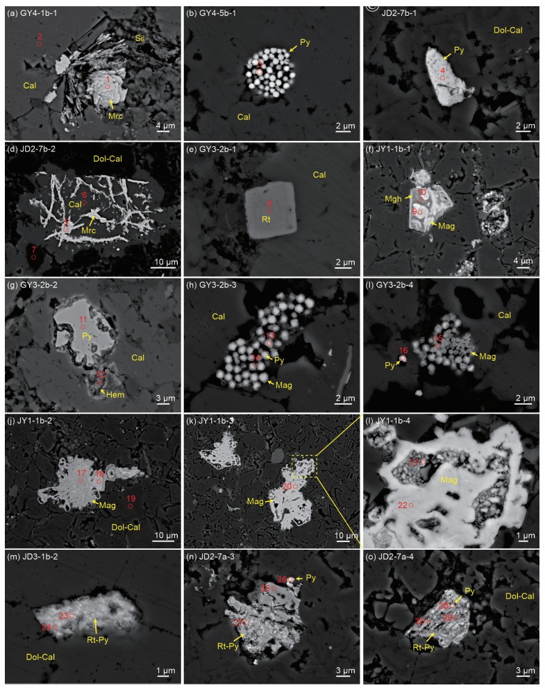
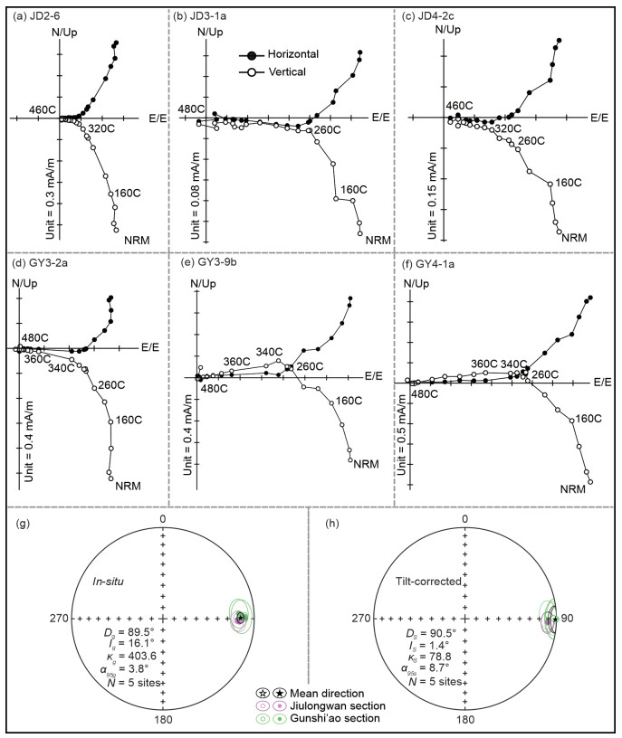
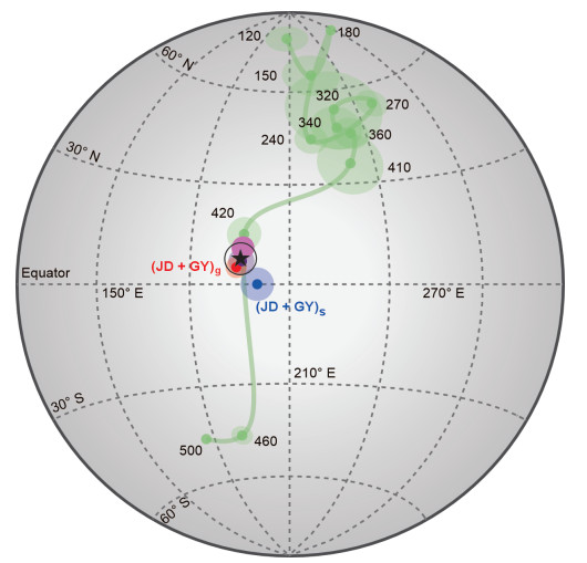
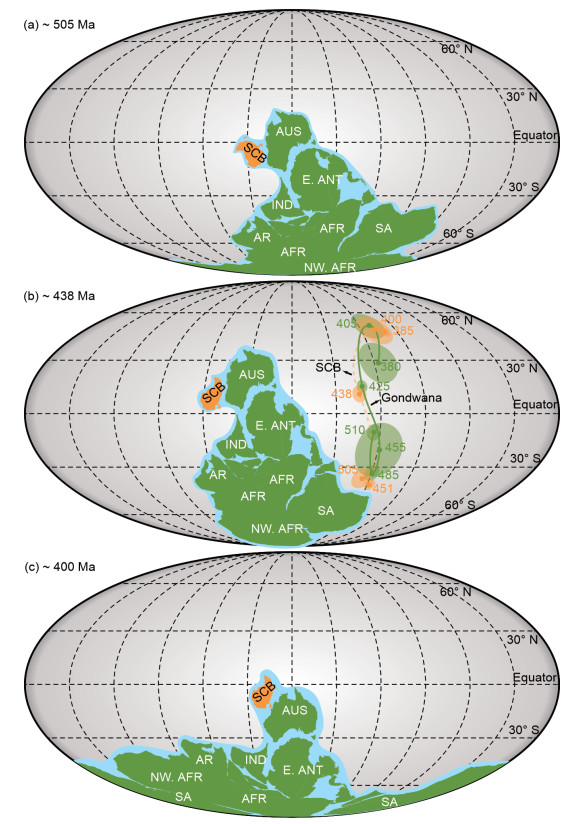
Paleogeographic reconstruction provides a key surface boundary condition for the study of many first-order Earth systems and geodynamic processes. However, scarcity of robust Early Paleozoic paleomagnetic data leads to a controversial reconstruction between the South China Block (SCB) and Gondwana. Here, we performed rock-magnetic, mineralogical and paleomagnetic analyses on the Ediacaran and Cambrian strata in the Jiulongwan and Gunshi’ao sections in the Three Gorges area, Hubei province in South China. Rock-magnetic and mineralogical analyses suggested that the secondary magnetite—formed via pyrite oxidation—is the main remanence carrier, recording a post-tilting remagnetization event associated with fluid alterations. Paleomagnetic measurements showed a new Early Silurian paleopole (5.0°N, 194.1°E,
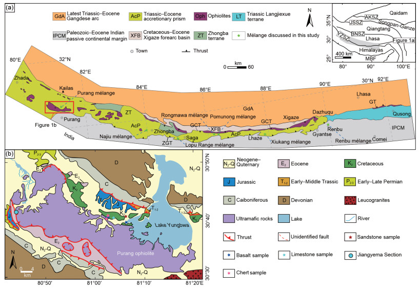
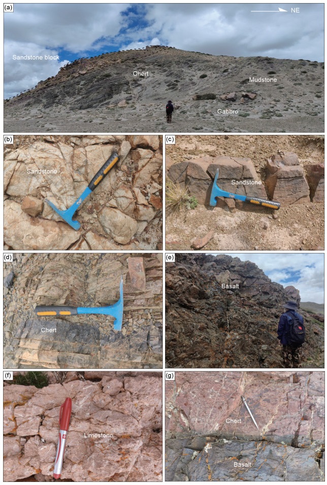
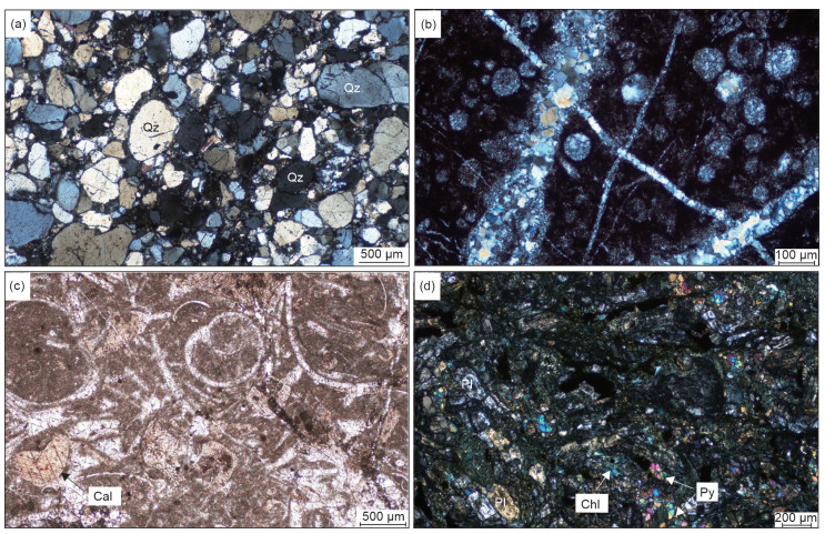
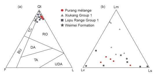
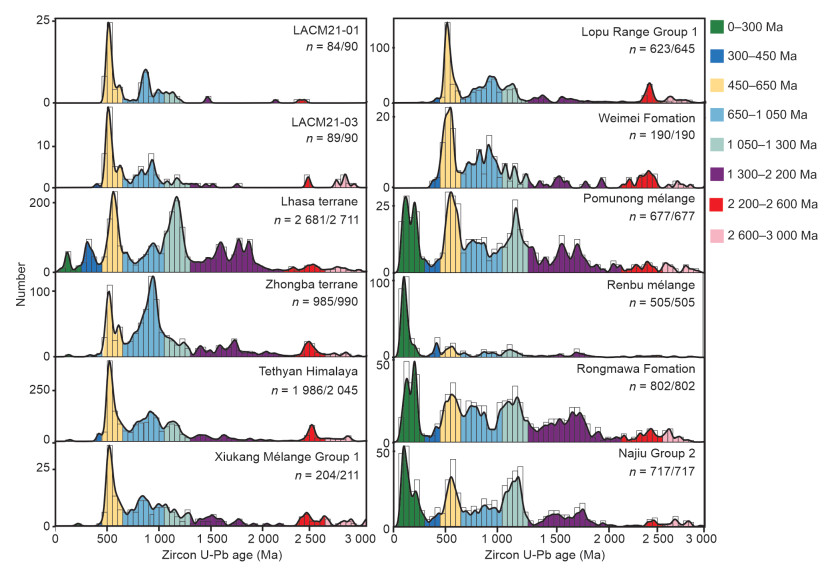
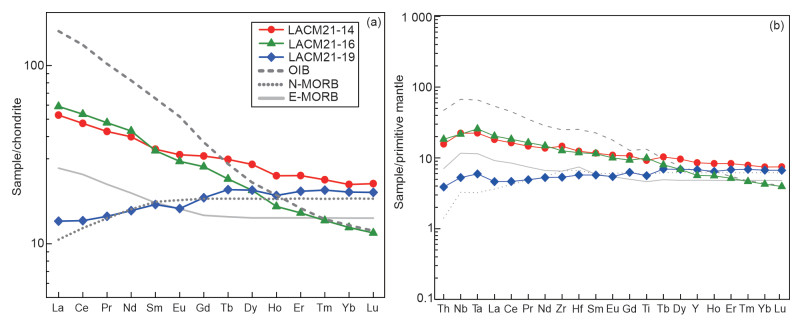
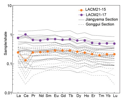
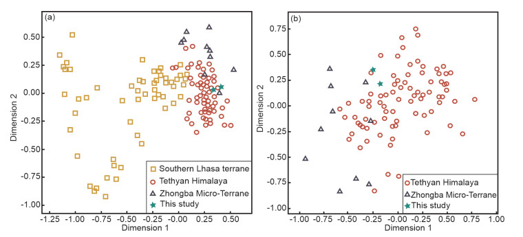
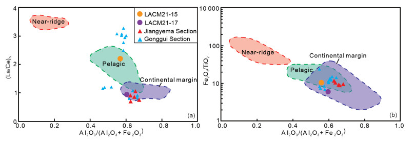
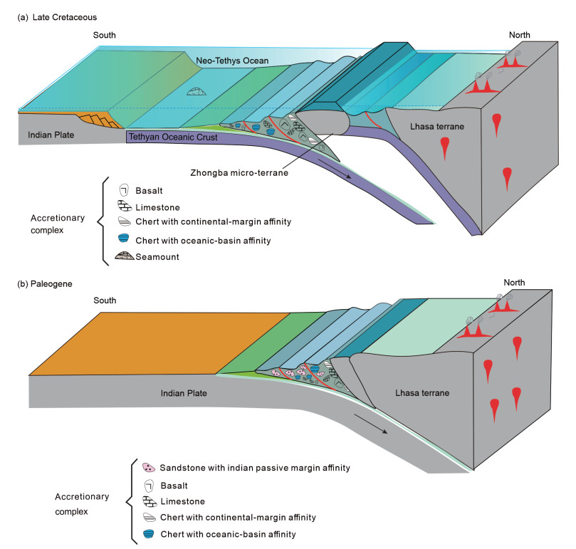
The Purang mélange, located within the western Yarlung Zangbo suture zone (YZSZ) in southern Tibet, provides valuable insights into the subduction-accretion process along the active southern margin of Asia during the Cretaceous–Paleocene Neo-Tethyan subduction. This mélange consists of sandstone, chert, basalt, and limestone blocks embedded in a mud matrix. We performed petrological and detrital zircon U-Pb geochronological analyses for the sandstone blocks to trace their provenances, while the whole-rock geochemical analyses for the chert and basalt to determine their sedimentary and tectonic settings. The sandstone blocks are primarily composed of quartz, with a few lithic fragments. Both of the sandstone samples exhibit detrital zircon U-Pb age ranges consistent with those of the Tethyan Himalaya. These results suggest that the sandstone blocks of the Purang mélange were derived from the passive continental margin of India. The basalt blocks exhibit three styles according to their geochemical characteristics, indicating that they originated from a subducted Neo-Tethyan slab. The chert blocks, however, display geochemical affinities of both pelagic and continental margins, indicative of a dual origin from both the subducted and overlying slabs. Based on the above observations, we propose a two-stage subduction-accretion process of the Neo-Tethyan Ocean. The basalt blocks were scraped from the subducted oceanic slab and incorporated into the subduction complexes during the Neo-Tethyan subduction stage of the Cretaceous, whereas the sandstone blocks of the passive continental margin reached the trench and were subsequently incorporated into the Purang mélange during the India-Asia collision stage of the Paleogene.
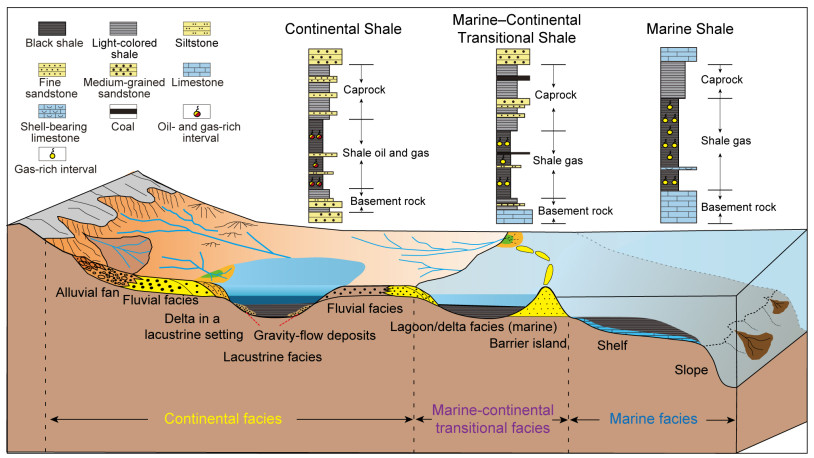
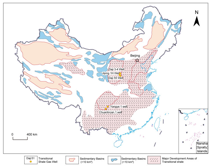
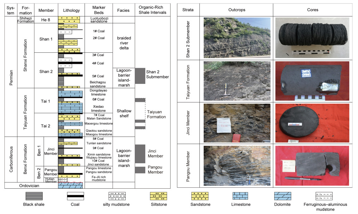
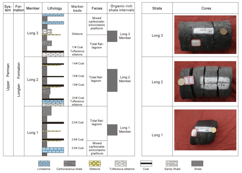
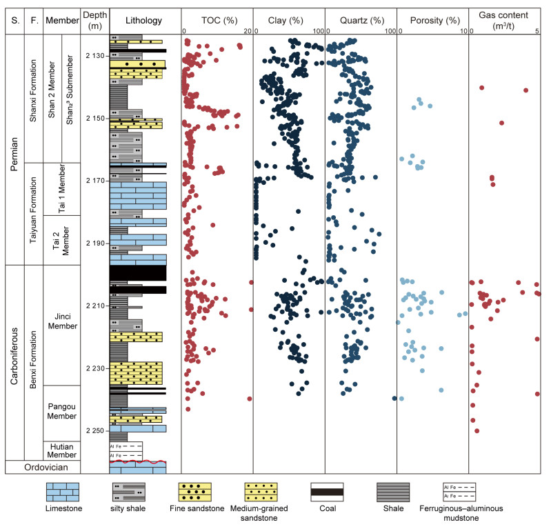
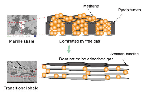
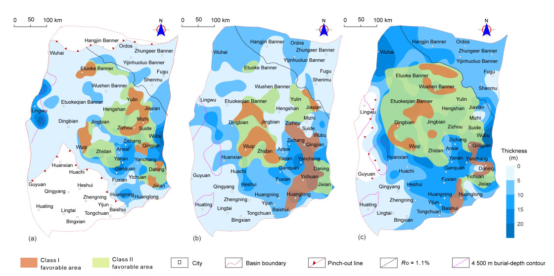
Marine-continental transitional (MCT) shale gas is an important successor of unconventional natural gas resource in China. Based on integrated analyses of published data including outcrop investigation, exploration practice, drilling cores, and experimental testing, the recent progresses of both global and domestic shale gas development were systematically reviewed and compared, and we further examined the exploration progress and challenges of MCT shale gas in the Ordos Basin, Sichuan Basin, and their adjacent areas, and conducted a comprehensive discussion of the key geological conditions for the formation of shale gas and its resource potential, challenges, and counter measures. The results show that MCT shale in China is mainly developed within the Carboniferous–Permian strata (Benxi, Shanxi, and Longtan formations), dominated by lagoon, swamp, and tidal flat facies, and possesses favorable conditions for shale gas formation and development potential. They mainly include the generation and storage of shale gas as follows: (1) The organic-rich intervals are thick and widespread, dominated by Type Ⅲ organic matter with high total organic carbon (TOC) content (≥3.0% on average) and moderate thermal maturity (
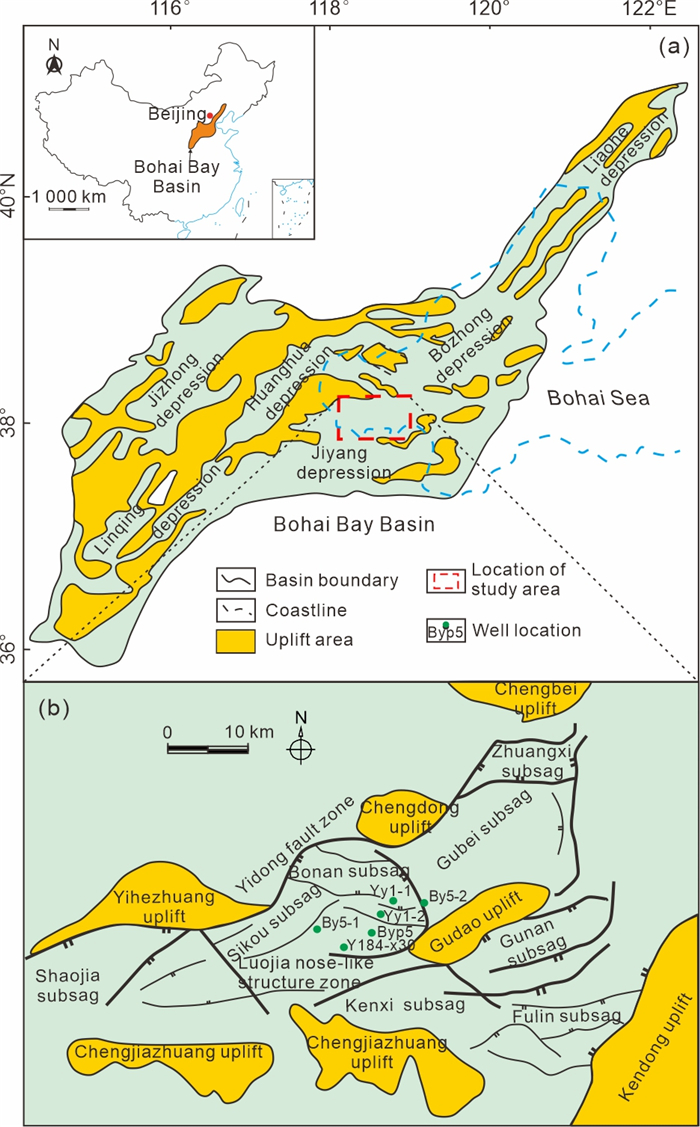
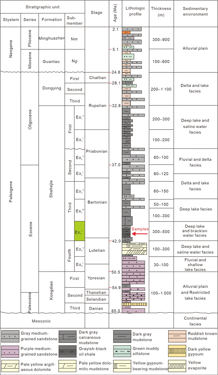
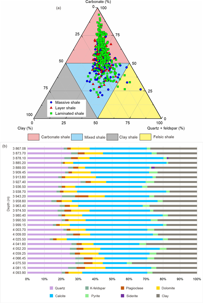
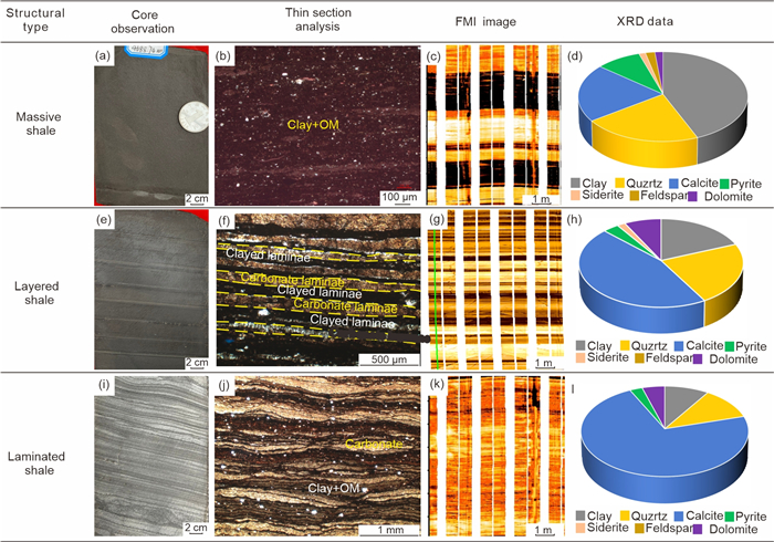
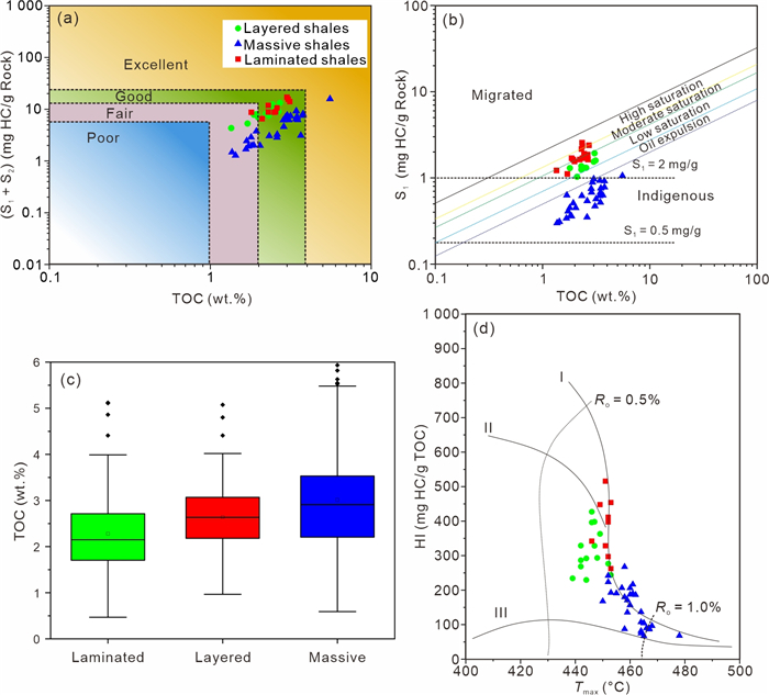
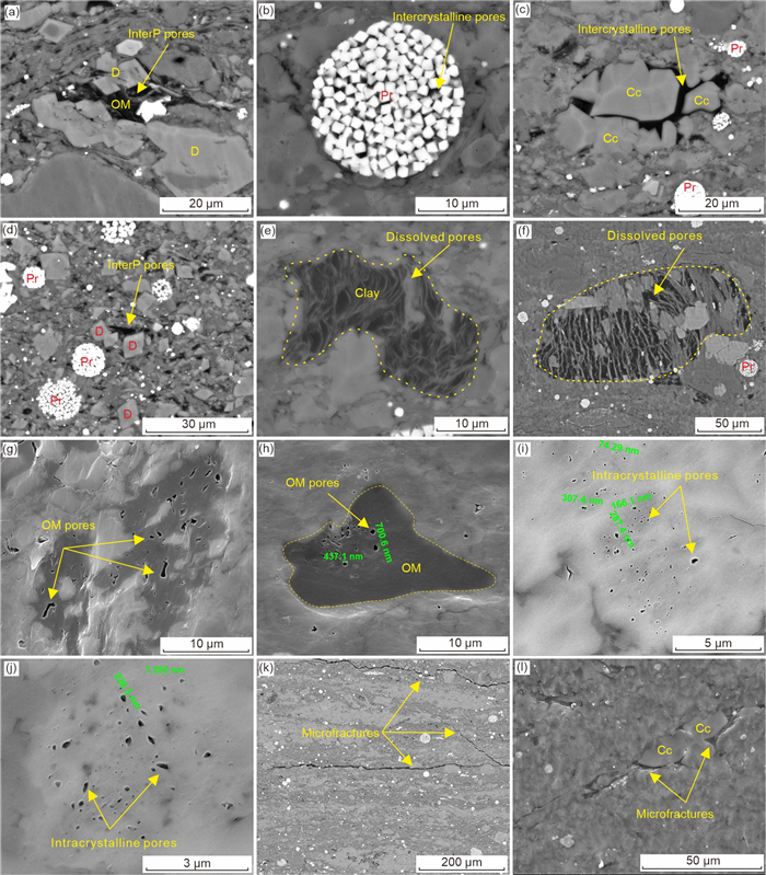
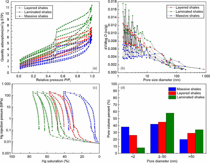
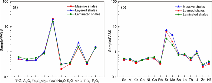
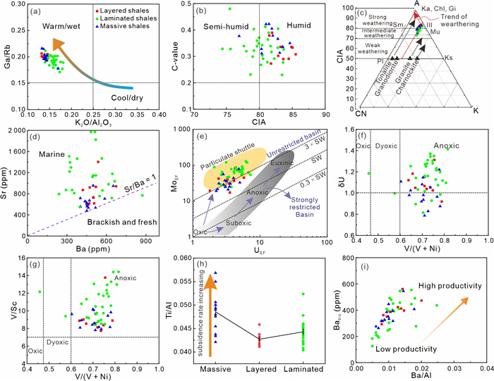
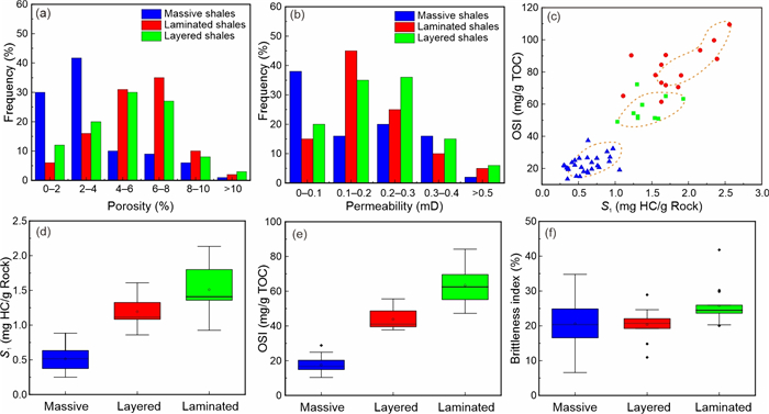
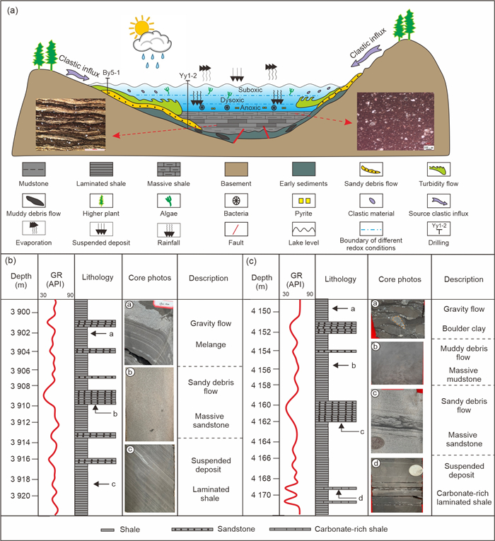
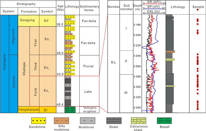
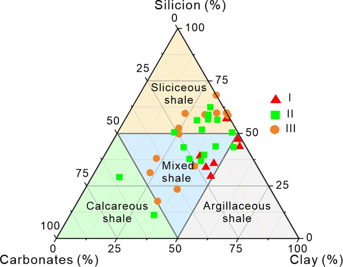
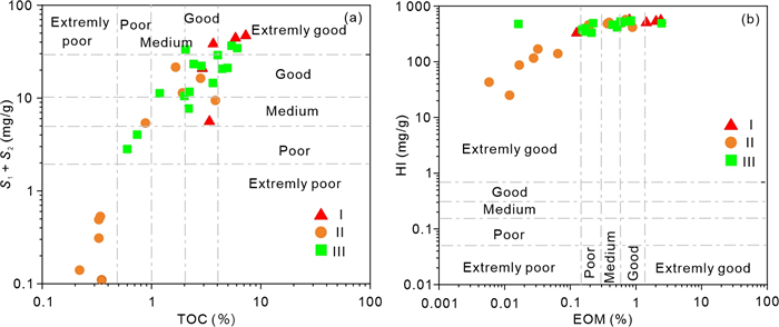
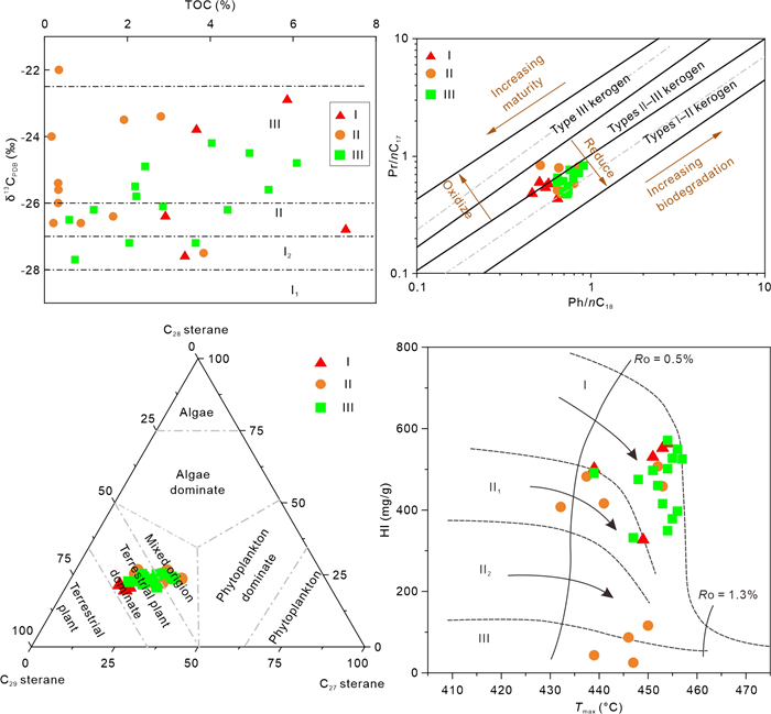
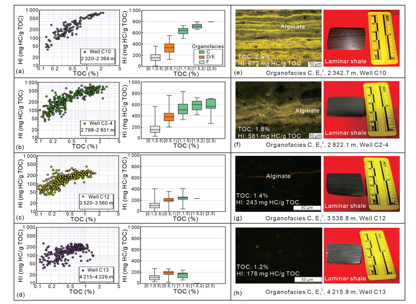
The Eocene Shahejie Formation in the Zhanhua sag of the Bohai Bay Basin has abundant shale oil resources. However, lacustrine shale is heterogeneous in mineralogy, sedimentary structure, organic matter, pore structure, paleoenvironment, and oil content. Therefore, the laminae assemblages are divided into laminated (lamina thickness of < 0.01 m), layered (0.01–0.1 m) and massive (no layer or layer spacing of > 0.1 m) types shale to investigate the core, X-ray diffraction (XRD), thin section, field emission-scanning electron microscopy (FE-SEM), mercury injection capillary pressure (MICP), N2 adsorption and geochemical experiments. The results show that the oil shale of the Shahejie Formation in Zhanhua sag is abundant in calcite. The TOC content ranges between 1.35% and 5.55%. Rock-Eval
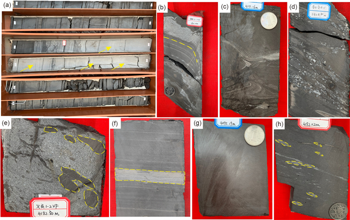
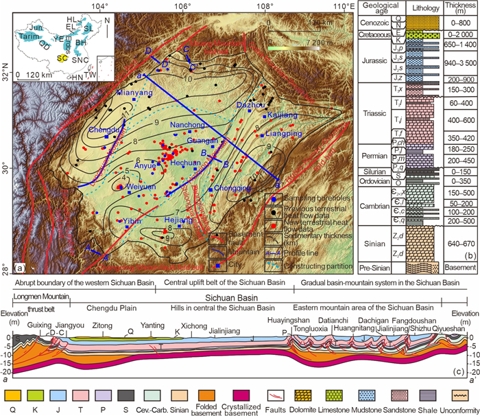
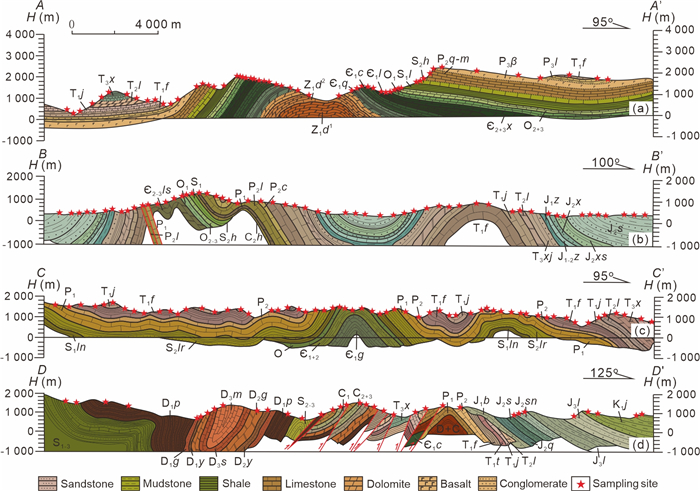
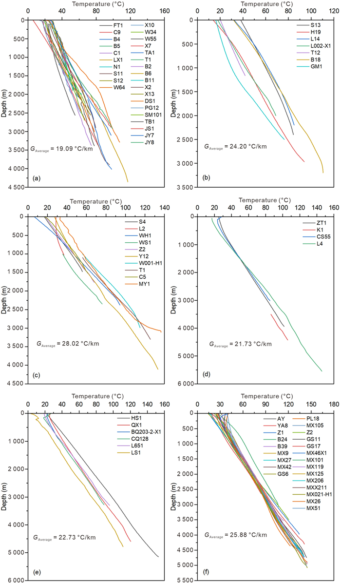
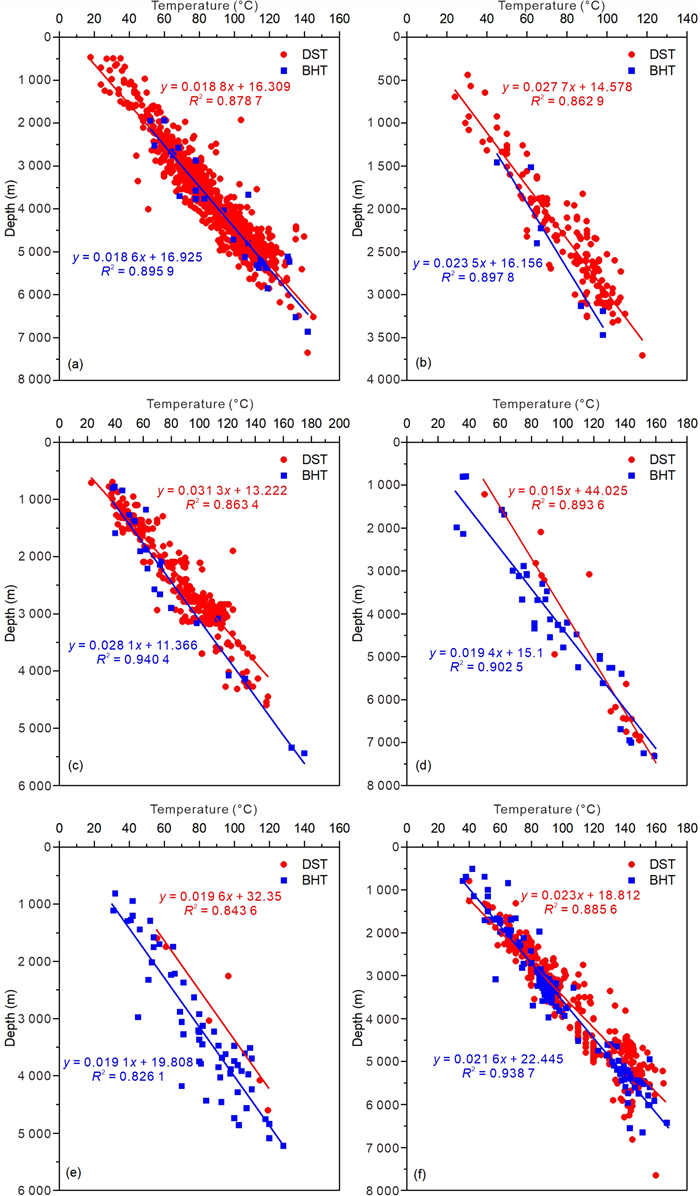
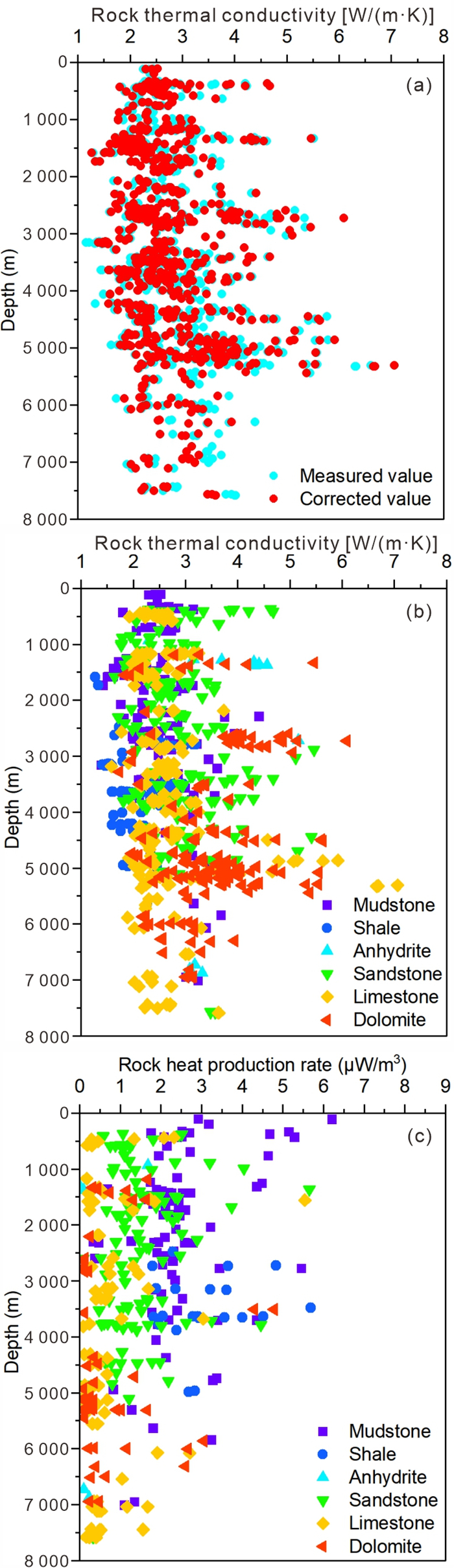
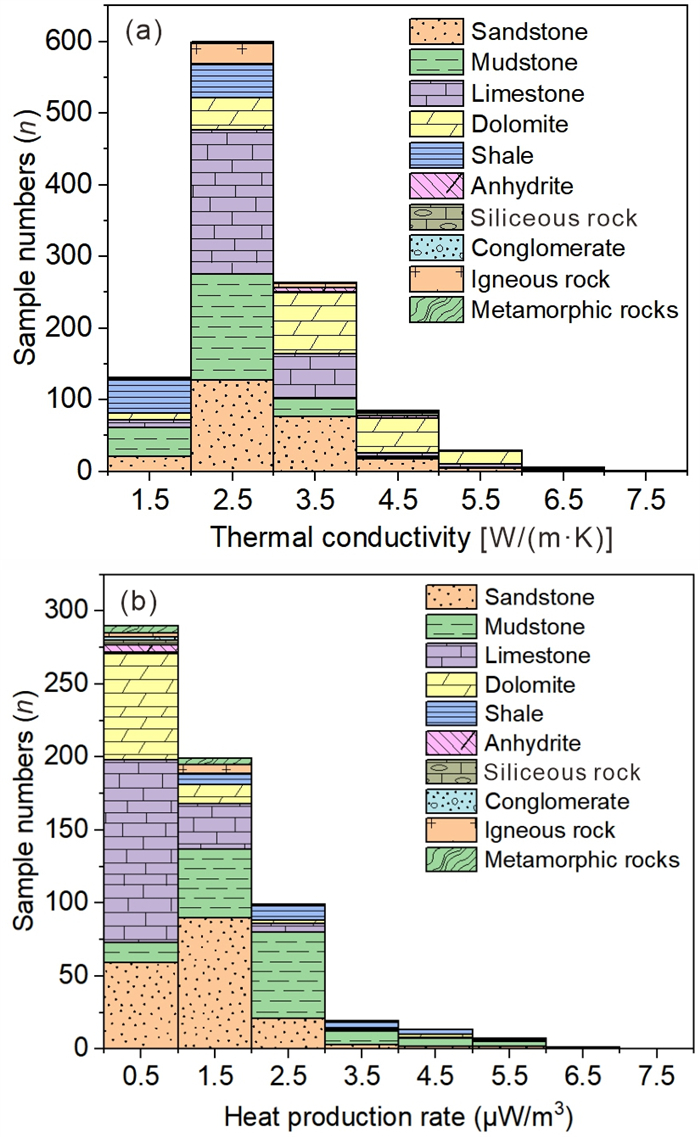
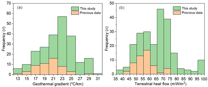
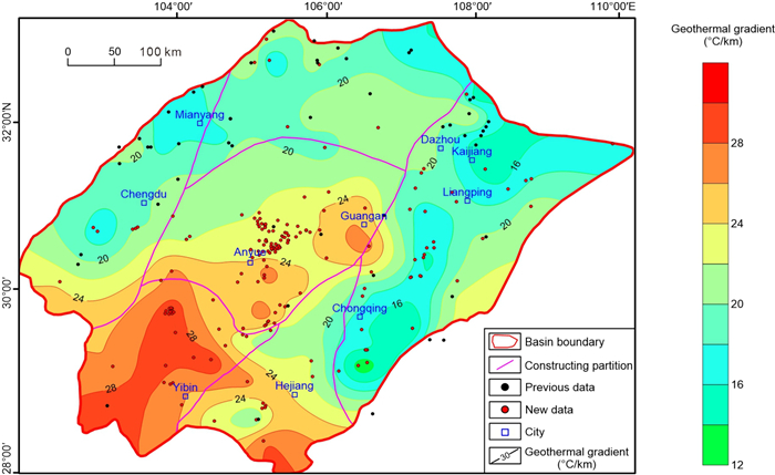
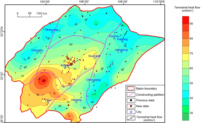
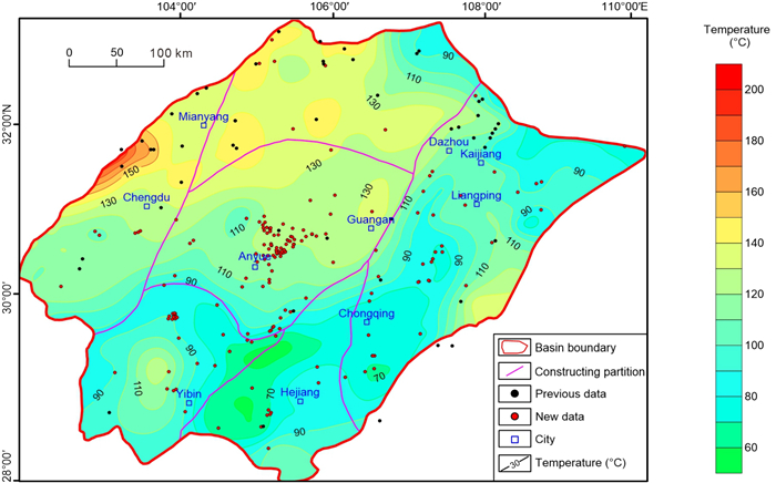
Terrestrial heat flow is a critical parameter that reveals the present-day thermal regime of sedimentary basins and plays a vital role in evaluating geothermal and petroleum resource potential. In this study, we present the most comprehensive update of heat flow measurements based on borehole measurements and thermophysical properties in the Sichuan Basin to date. The geothermal gradient and terrestrial heat flow of 177 typical boreholes in the Sichuan Basin were calculated using the system steady-state temperature data from 65 boreholes, drilling stem test temperature data from 112 boreholes, 1 116 rock thermal conductivities and 629 heat production rates. The results show that the Sichuan Basin is characterized by a medium-temperature field between those of stable and active tectonic areas; the geothermal gradient and terrestrial heat flow ranges of 12.2–30.5 ℃/km and 38.0–98.9 mW/m2, with average values of 21.9 ± 3.85 ℃/km and 64.5 ± 12.8 mW/m2. The terrestrial heat flow and geothermal gradient distribution characteristics in the Sichuan Basin are consistent and mainly controlled by factors such as the regional geological structure, rock thermal conductivity and deep heat sources of the Sichuan Basin. High terrestrial heat flow values lie within the basement uplift region of the southwestern Sichuan Basin and the central Sichuan Basin; the terrestrial heat flow decreases from the southwestern Sichuan Basin to the surrounding depression areas. In the southwestern Sichuan Basin, central Sichuan Basin uplift and southern Sichuan Basin, the terrestrial heat flow ranges of 52.6–98.9 mW/m2, with an average value of 72.5 ± 9.7 mW/m2. In the eastern Sichuan Basin and northern Sichuan Basin, it varies from 38.0–70.7 mW/m2, with an average value of 53.2 ± 6.6 mW/m2. These results offer a robust fundamental insight for thermal regime of the Sichuan Basin and its geothermal and petroleum resource assessment.

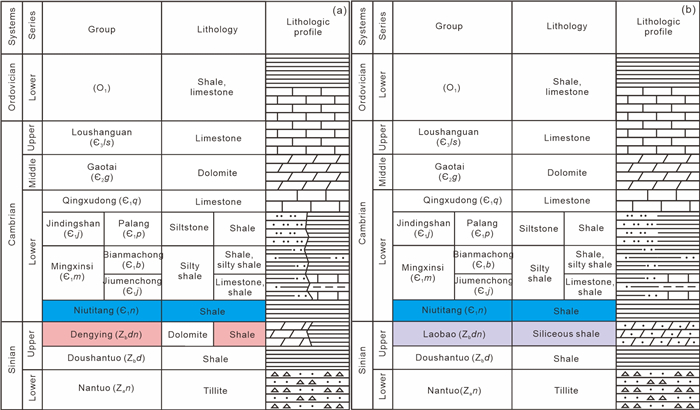
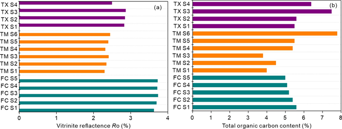
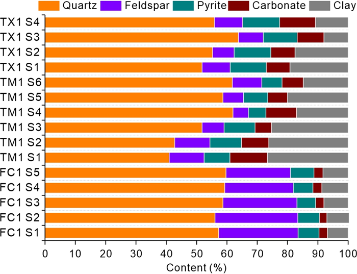
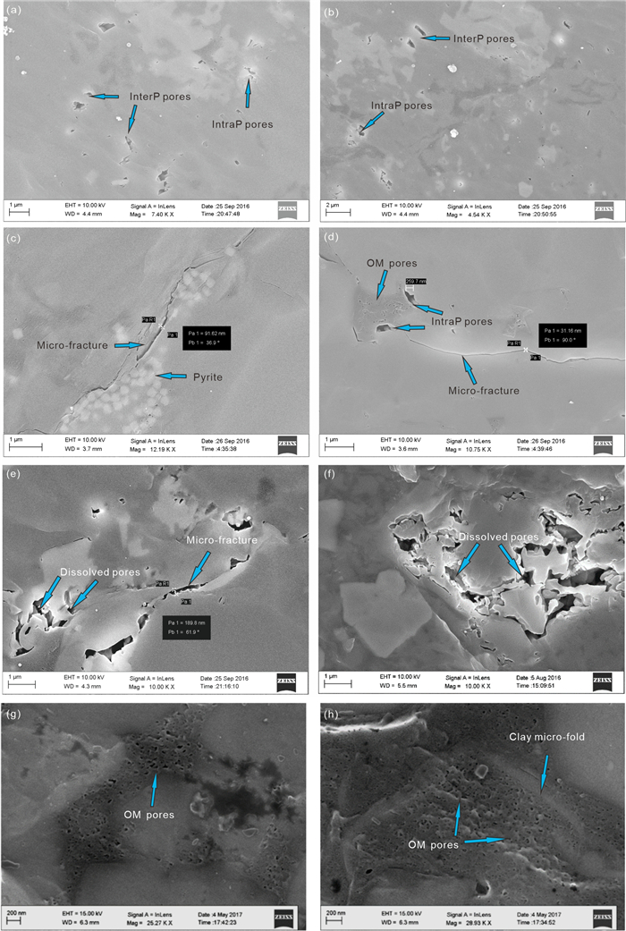
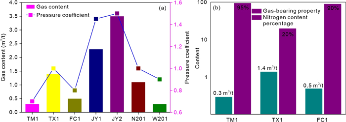
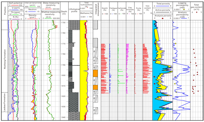
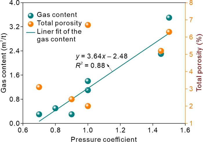
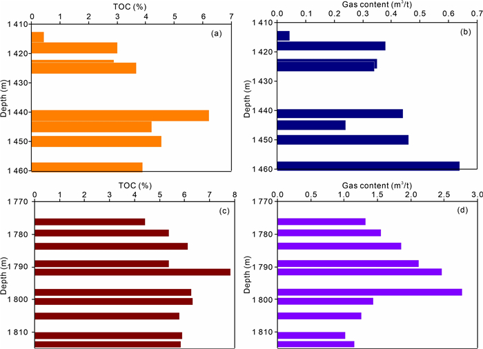
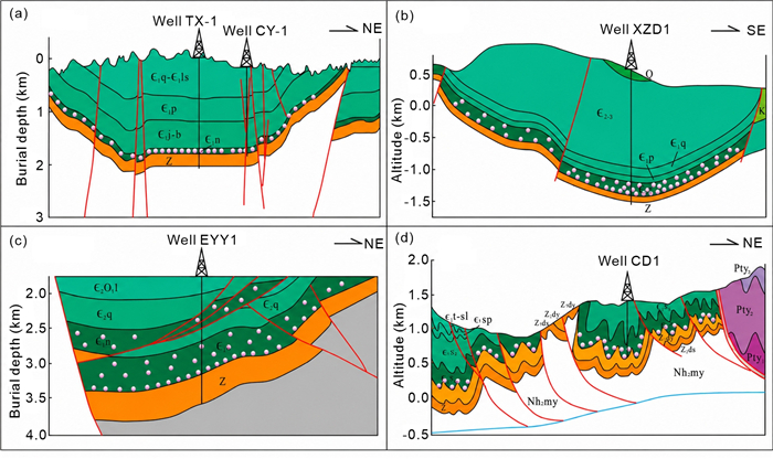
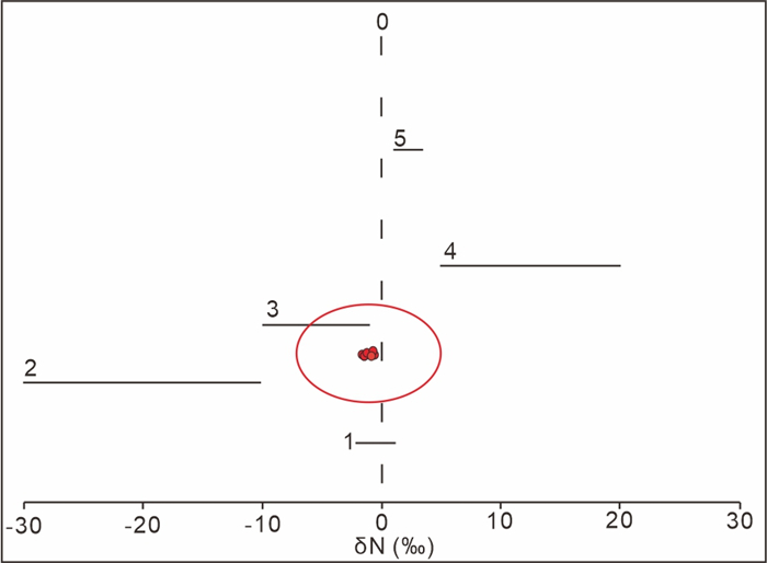
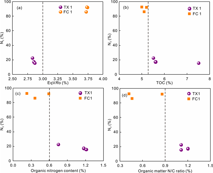
The Lower Cambrian Niutitang Formation is a crucial stratum for the exploration of normal-pressure marine shale gas in southern China, with great development potential. To research the normal-pressure shale gas accumulation of the Niutitang Formation in the complex tectonic zone, the shale cores in northern Guizhou were subjected to X-ray diffraction (XRD) and field emission scanning electron microscopy (FE-SEM) observation, and tests were conducted to determine total organic content (TOC), bitumen reflectance, and nitrogen isotopes. The results indicate that the equivalent vitrinite reflectance of cores varies from 2.30% to 3.73%, and the TOC content of cores varies from 3.8% to 7.8%. The total gas content of three wells in northern Guizhou is 0.5, 0.3, and 1.4 m3/t, respectively. The TOC content of the shale in the syncline structure is higher than that of the shale in the anticline structure. Nitrogen in shale gas originates primarily from the thermal ammoniation of organic matter, the atmosphere, and the deep crust. Shale gas preservation is favorable in regions with a large range of lifting, and small lifting differences. The syncline is broad and gentle with few faults have better gas accumulation conditions. The Niutitang Formation in the residual syncline of the study area has better gas content than that of other structures. Exploration of shale gas accumulation sweet spots in northern Guizhou should focus on the broad-gentle synclines with minimal changes in stratigraphic lifting, few faults, and no hydrothermal activity at the edges of paleo-uplifts.
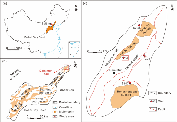
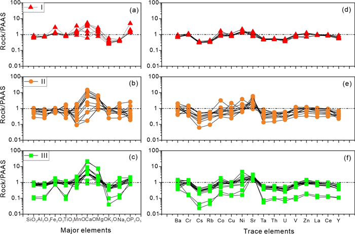
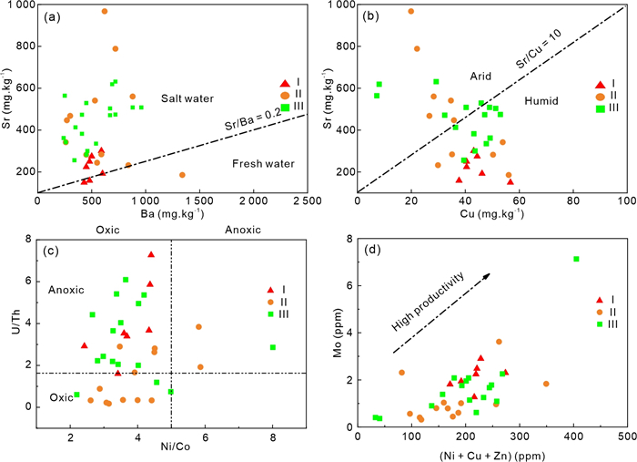
The unique sedimentary environments and subsequent diagenetic transformations in continental saline lake basins markedly shape the varied nature and characteristics of saline lacustrine shales, thereby ultimately affecting how lacustrine organic matter (OM) accumulates. However, what chiefly governs OM enrichment in such settings is still not fully understood. This research focuses on the Damintun sag as a prime research example, utilizing an extensive array of methods like total organic carbon (TOC) analysis, X-ray diffraction, pyrolysis, trace element analysis, and isotopic studies on shales from the Paleogene period. The objective was to shed light on the variability in OM concentration and its ties to the paleoenvironment. Findings reveal that the E
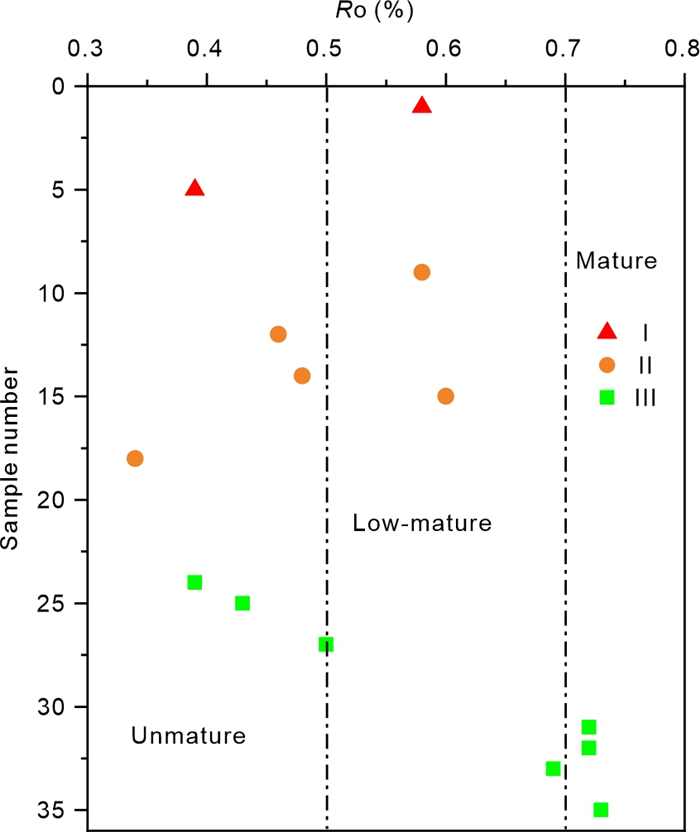
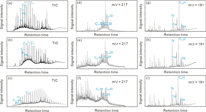
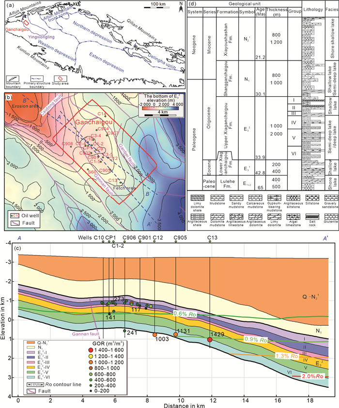
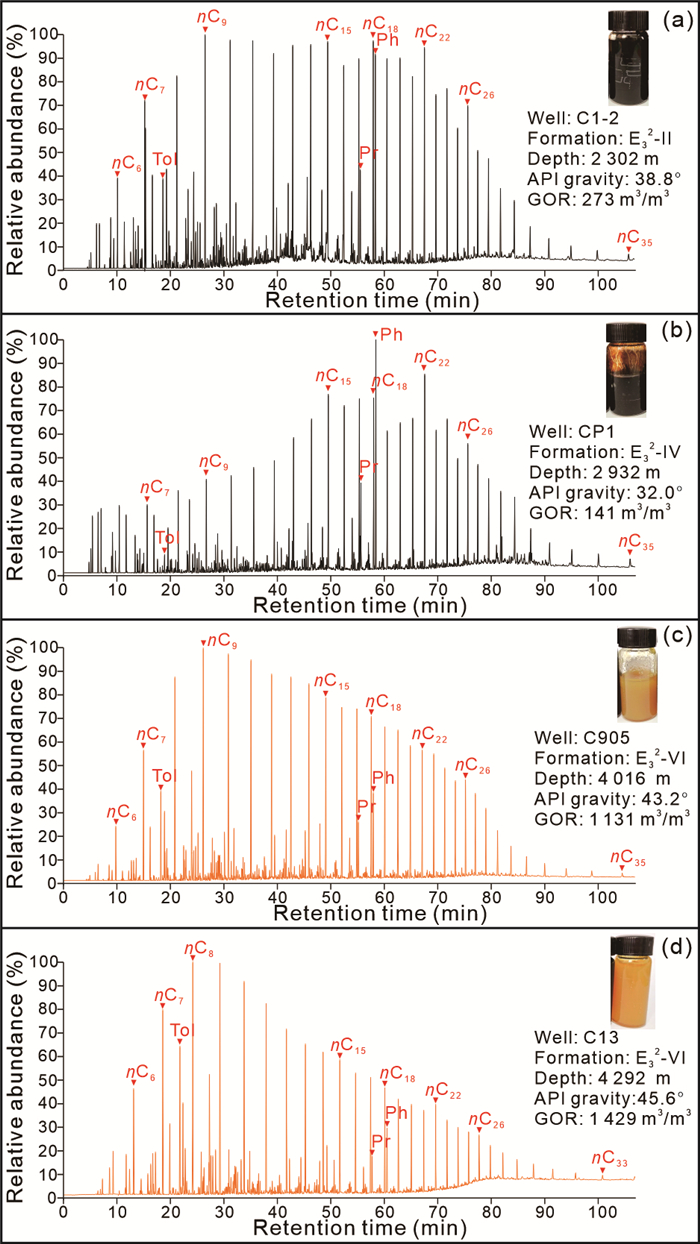
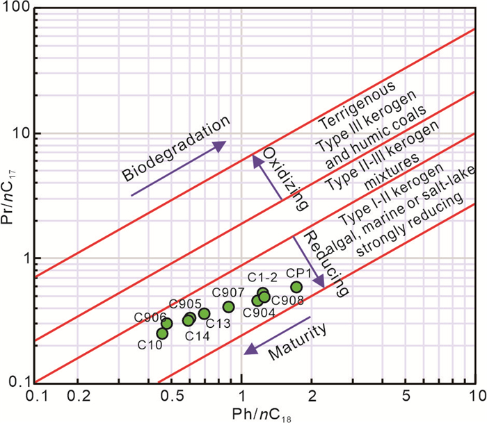
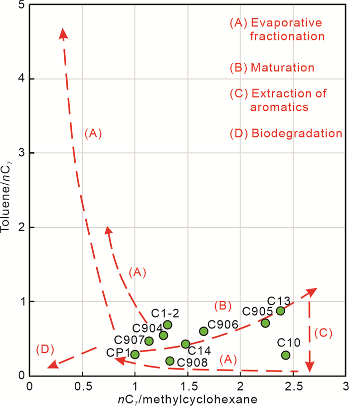
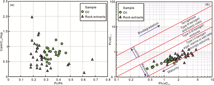
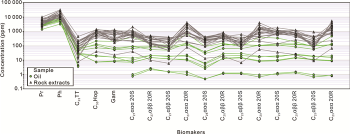
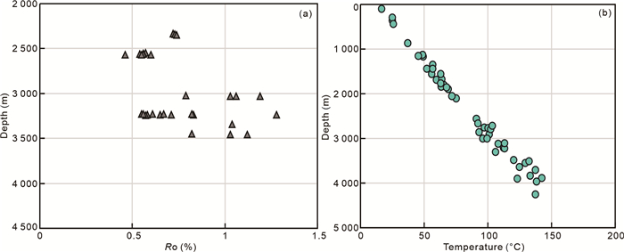
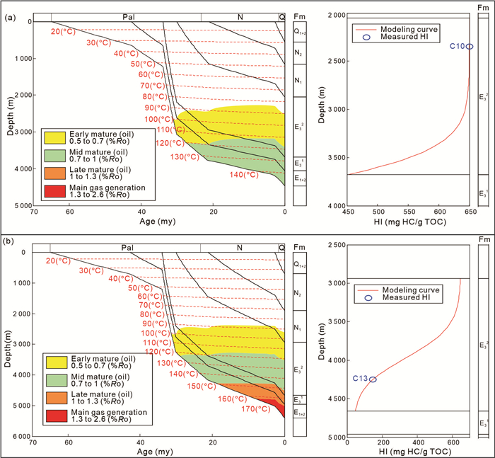
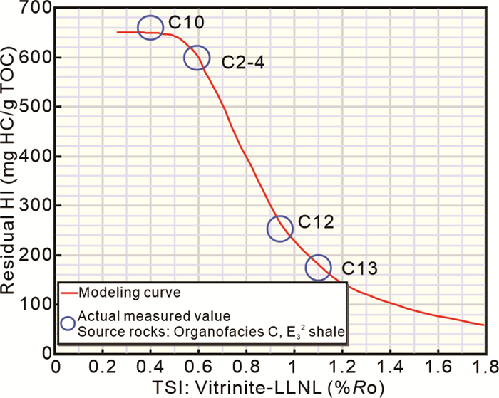
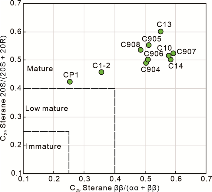
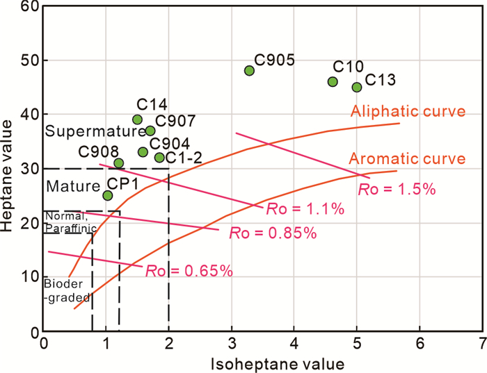
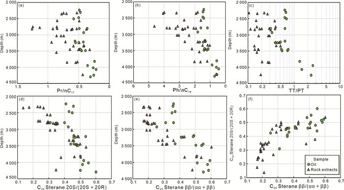
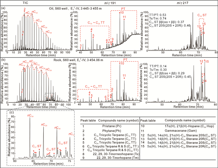
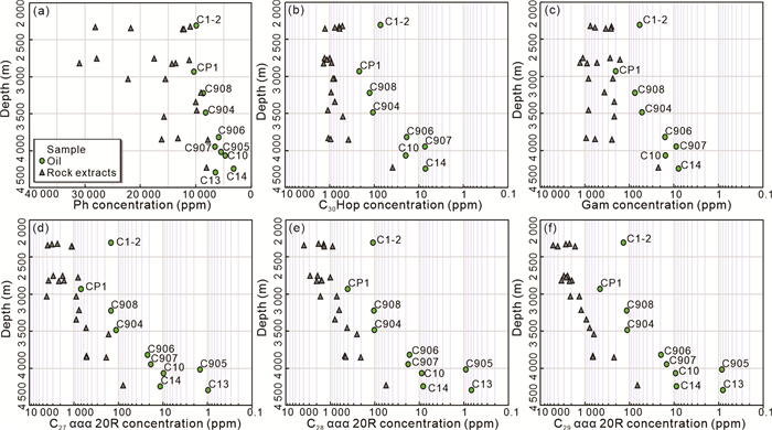
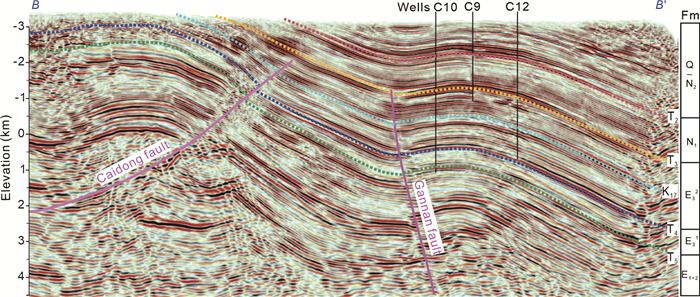
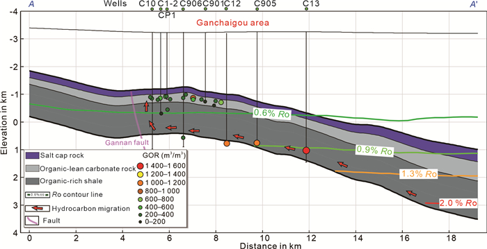
Shale oil is generally considered to be petroleum generated from organic-rich mudstones and retained in place, or having migrated over a short distance and stored in adjacent organic-lean interbeds. However, in our study on the origin of petroleum in the Upper Xiaganchaigou Formation (E32), Ganchaigou area, western Qaidam Basin, China, we found that the E32 shale reservoirs have experienced large-scale and long-distance hydrocarbon migration and accumulation. This study utilizes organic geochemistry and basin modeling to characterize the maturity of crude oil and source rocks within the E32 shale reservoir. The results indicate that crude oil found in the immature to low-mature zone exhibits mature to overmature characteristics in organic geochemical and physical properties. In the strata within the oil window, the biomarker parameters and their absolute concentrations in crude oil still show significant differences from those of
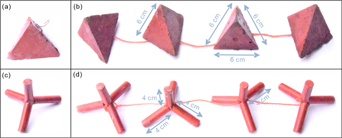
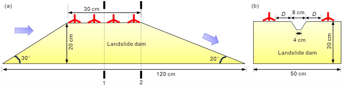
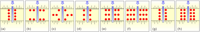
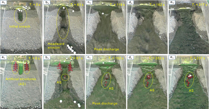
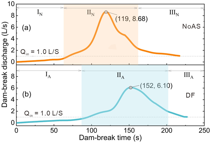
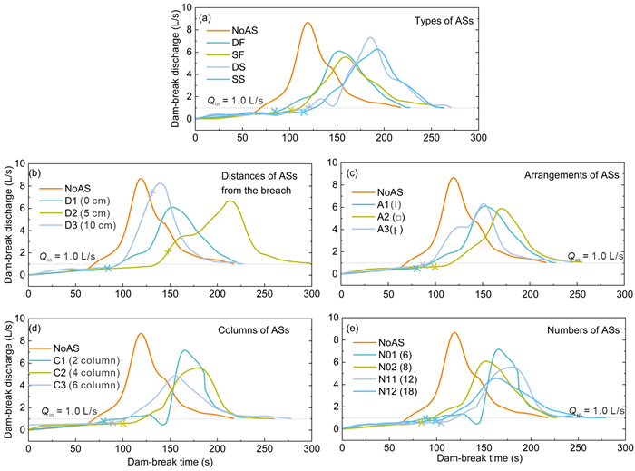
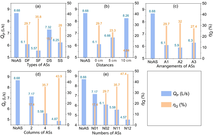
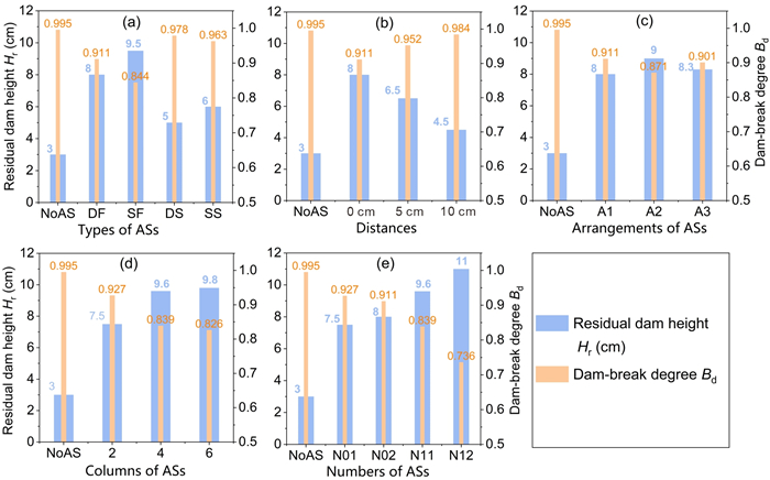
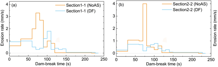
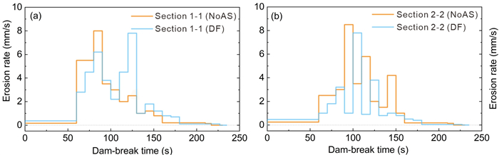
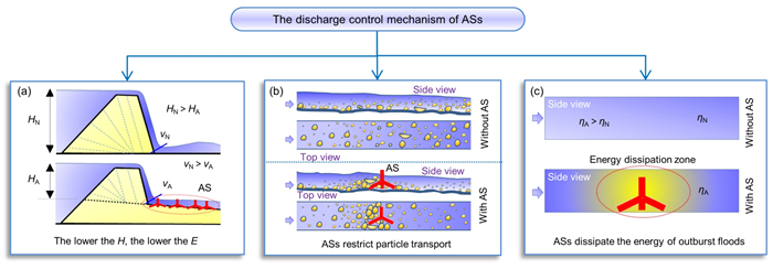
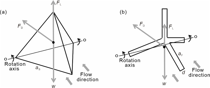
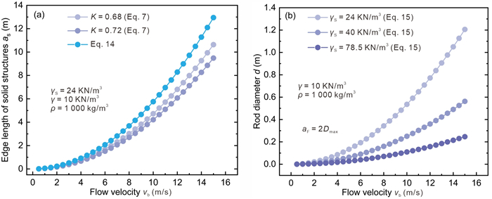
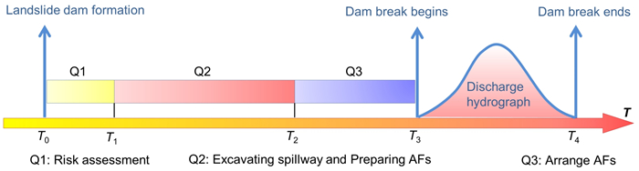
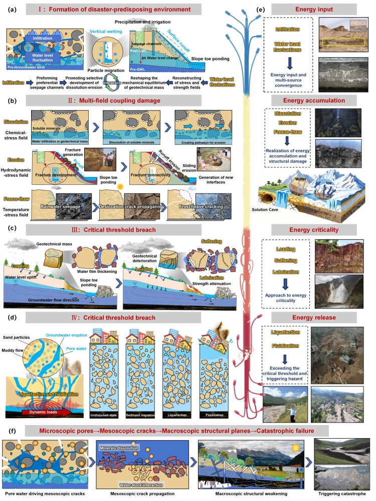
The scale of the outburst flood resulting from a landslide dam failure significantly influences the extent of the disaster and losses downstream. This study proposes a method for controlling the discharge of landslide dam failure using the artificial structure (AS). The primary approach involves strategically arranging the designed AS on both sides of the excavated spillway. As the breach is eroded, ASs gradually fall into the breach, serving to control the discharge. Fourteen sets of flume experiments were conducted to investigate the impact of various factors, including AS types, distances from the breach boundary, arrangements, columns, numbers, on the discharge control effectiveness. The mechanism how AS controls outburst discharge was revealed. Results indicate a pronounced control effect of AS on landslide dam-break discharge, with the maximum reducing rate of the peak discharge in the experiment reaching 47.4%. In controlling outburst discharge, four-sided framed structures demonstrate superior performance compared to four-sided solid structures, and serial structures outperform discrete structures. When arranging ASs, it is essential to ensure that the structure initiates its descent into the breach at the onset of the rapid increase in outburst discharge and continues until the peak discharge occurs. Building upon this foundation, augmenting the number of ASs and columns significantly enhances the efficacy of discharge control. The fundamental rationale for this discharge control lies in the AS's capacity to reduce the headward scarp height, constrain sediment transport, and diminish the erosion capacity of the outburst flood, ultimately lowering the breach erosion rate. Lastly, a calculation method for the size design of the AS is established based on mechanical analysis. The research findings offer a new technological option for the emergency disposal of landslide dams.

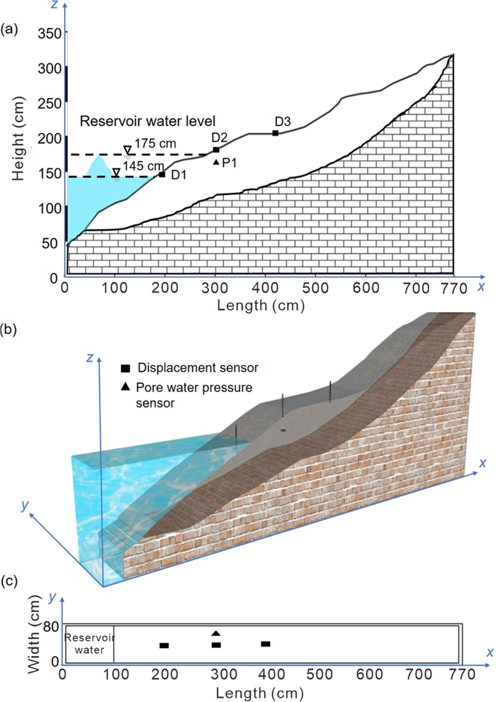
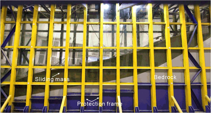
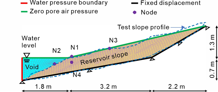
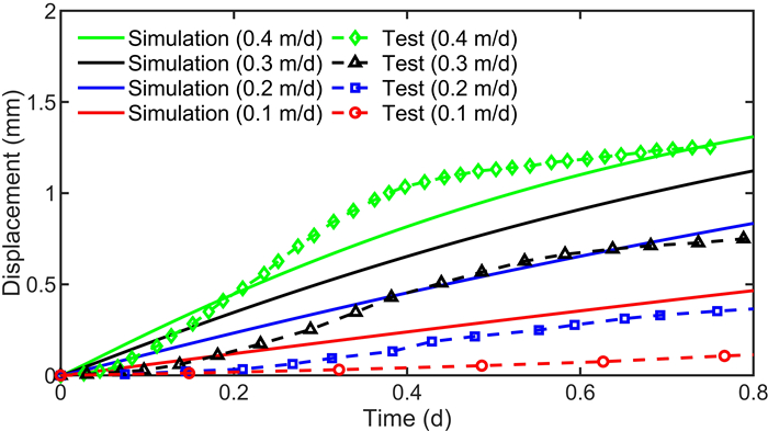
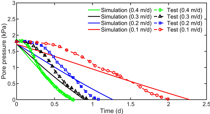
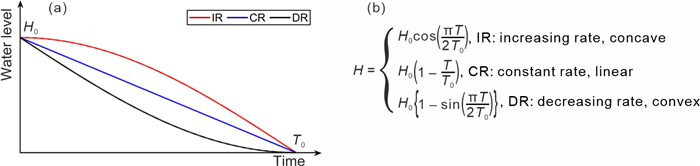
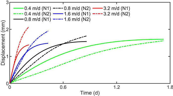
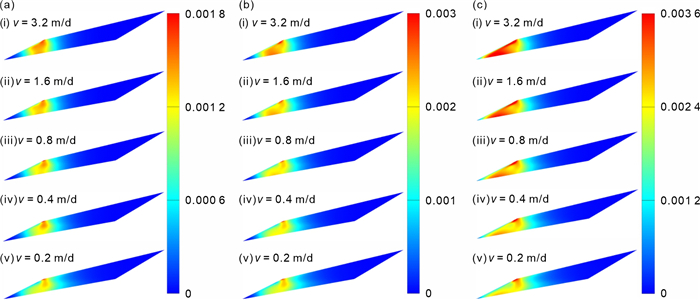
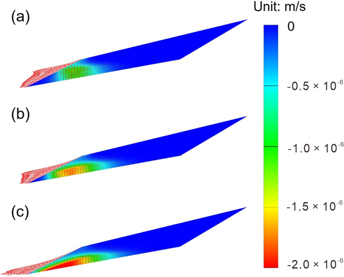
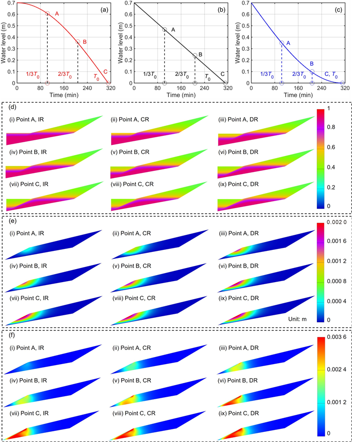
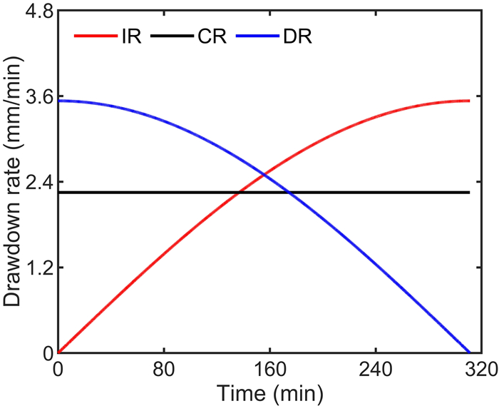
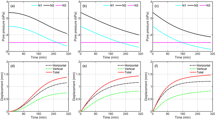
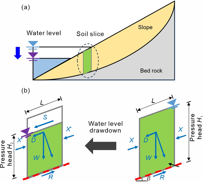
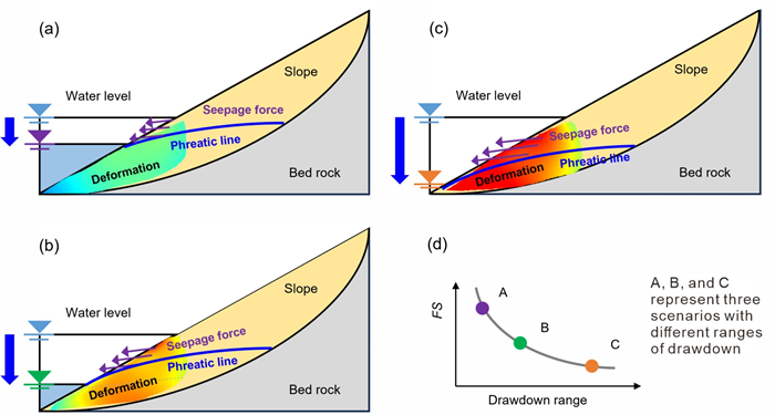
Seepage and deformation of a large-scale reservoir slope model under water level drawdown was first studied using the self-developed testing platform. Coupled seepage-deformation finite element analysis was then performed to simulate the dynamic hydromechanical behavior. A parametric study was finally conducted to elucidate the influence of drawdown rate, range, and mode on the seepage and deformation characteristics. When the drawdown rate is over 0.1 m/d, the increase in drawdown rate induces a faster change in pore water pressure and more intensified slope deformation. As the water level is reduced by more than 57%, the lower part of slope is significantly mobilized and the slope is subjected to the larger seepage force, decreasing slope stability and causing greater slope deformation. Under drawdown with the convex (increasing rate), linear (constant rate), and concave (decreasing rate) modes, the degree of saturation, pore water pressure, soil displacement, and slope deformation show the fastest response in the convex mode while the slowest response in the concave mode, and the characteristics of the hydromechanical responses are distinctly different during different modes of drawdown. However, the ultimate slope deformation does not vary much in each scenario when the same range of drawdown completes within the same time.
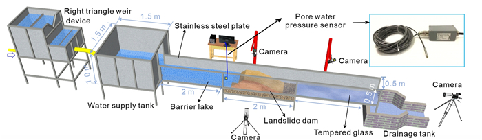
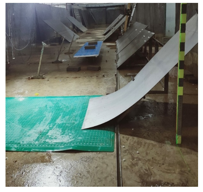
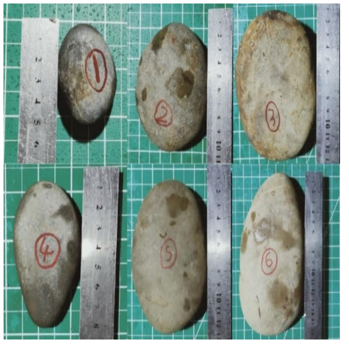
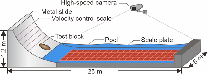
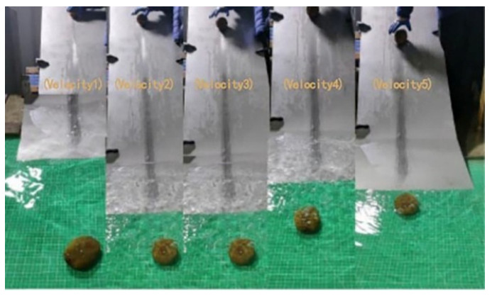
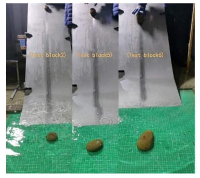
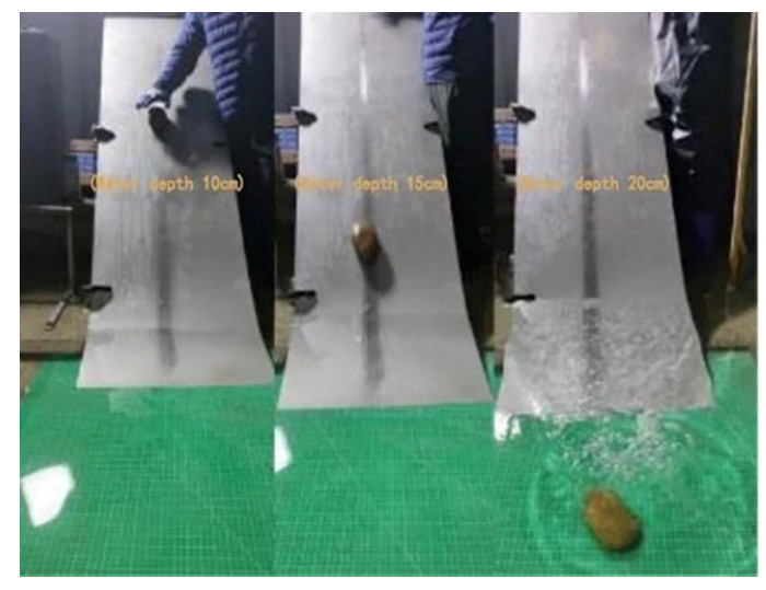
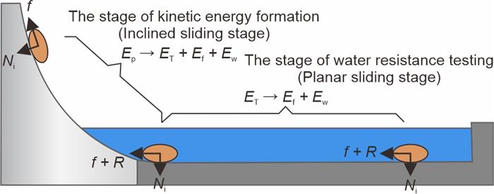
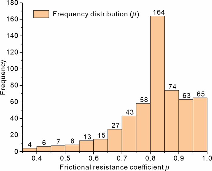
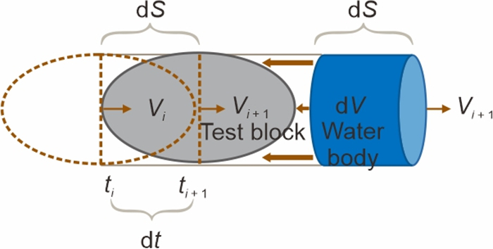
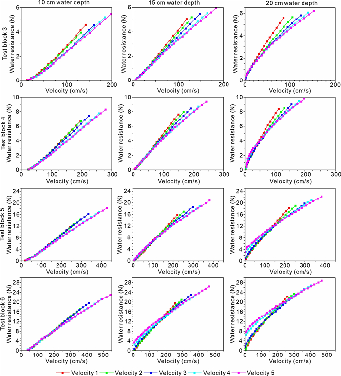
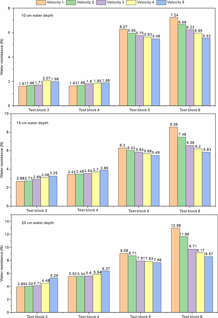
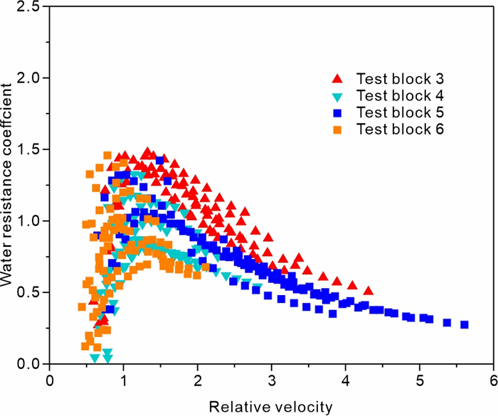
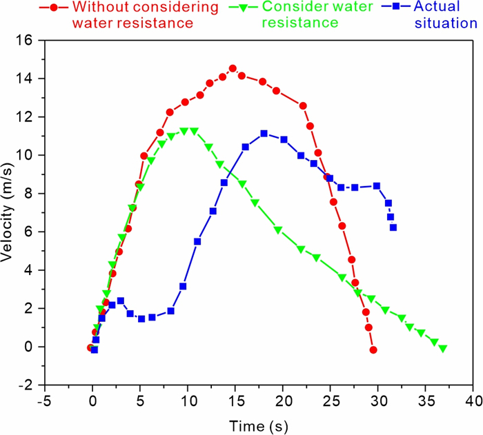
A high-speed riverbank landslide entering the water can pose a great threat to public facilities and the lives of residents on both sides of the riverbank. Therefore, the precise calculation of riverbank landslide speed is very important for disaster assessment. Water resistance is one of the key factors affecting the speed of riverbank landslide. In order to quantify the resistance calculation of reservoir bank landslides and further provide experimental data and a theoretical basis for the analysis of the velocity of reservoir bank landslides, this study has developed an experiment to investigate the water resistance coefficient. The experiment features a water tank, a sloped section, and a smooth section. The sloped section is designed to accumulate kinetic energy in the landslide before it enters the water, while the smooth section is used to study the water resistance coefficient. Based on the dynamic and kinematic equations for underwater test blocks, a model for calculating the comprehensive water resistance coefficient has been established. The experimental results were analyzed through dimensionless methods, examining the impact of various dimensionless factors on the water resistance coefficient. The model for calculating the comprehensive water resistance coefficient was derived from multiple regression analysis. The theoretical formula for water resistance coefficient has a fitting degree of 0.77, indicating good accuracy. The study has proposed a sophisticated model for calculating the water resistance coefficient, enhancing the understanding of this coefficient. This advancement enhances the precision of predicting the inflow velocity of landslides into reservoirs, thereby improving the predictive accuracy of tsunami models triggered by such landslides.

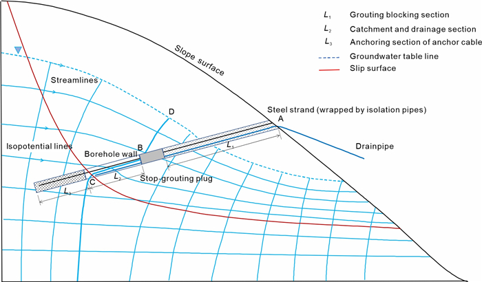
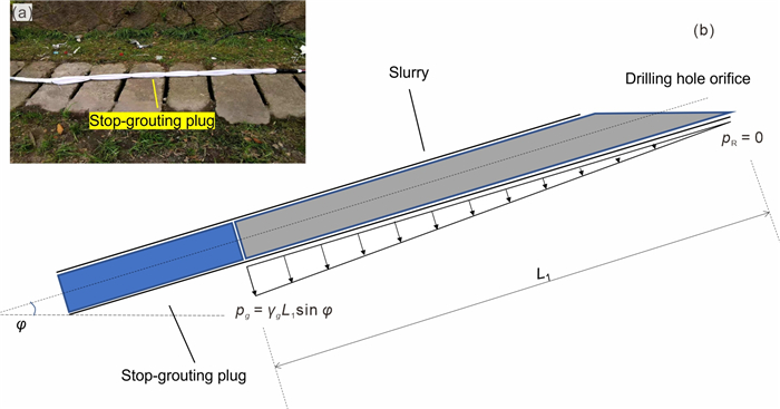
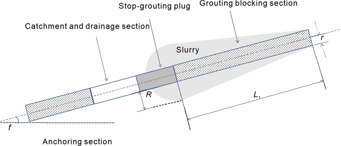
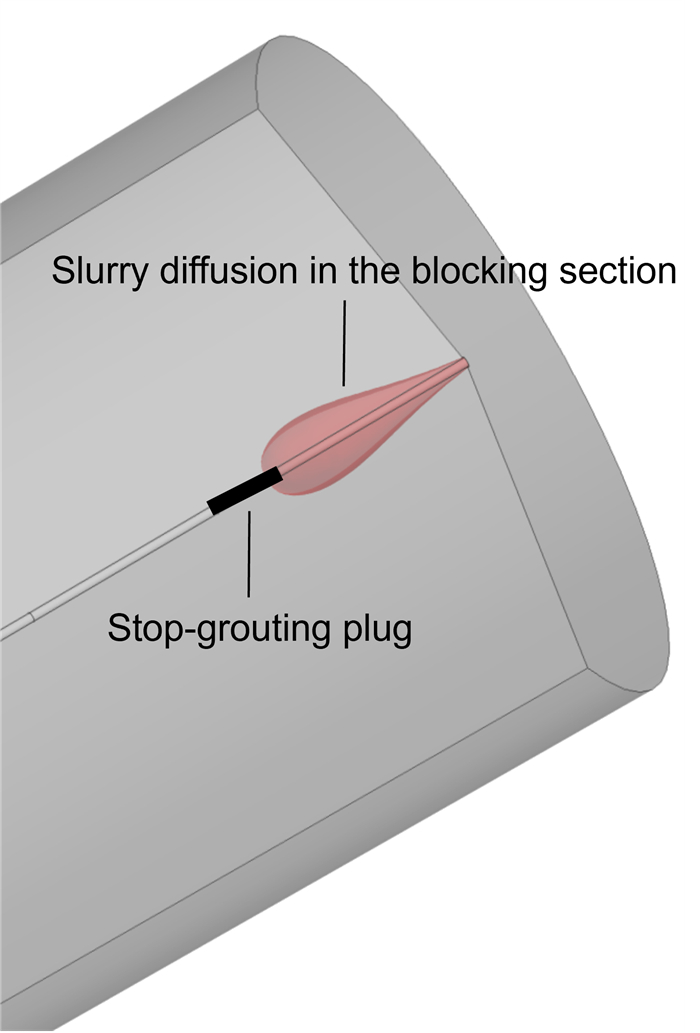
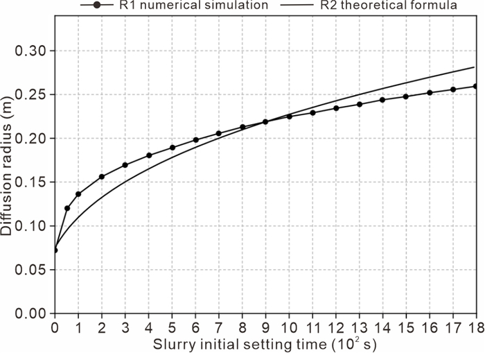
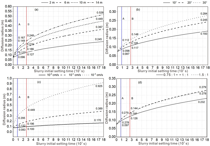
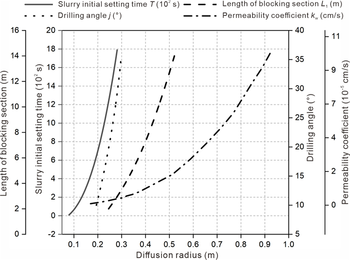
A new self-starting drainage anchor that combines prestressed anchor cables with self-starting drainage is proposed. The novelty of the self-starting drainage method is the realization of the drainage and anchoring in the one inclined borehole. Reduction in the number of boreholes can greatly decrease the construction cost and duration of the project. The adverse effect of drilling construction disturbance on the slope is reduced. To tackle the possible blockage of the drainage cavity due to slurry leakage during the solidification process after finishing grouting in the blocking section. To this end, a theoretical equation for the slurry diffusion radius under slurry self-weight pressure boundary conditions is deduced. The result is verified for precision through comparison with numerical simulation. The findings reveal that the permeability coefficient of rock and soil mass has the most significant impact on the slurry diffusion radius, succeeded by the length of the grouting blocking section, slurry initial setting time, and drilling inclination in descending order of influence. With the 5% mass ratio of a "711" type slurry quick-setting agent, the maximum slurry diffusion radius can be reduced from 0.925 to 0.449 m, a reduction of 0.476 m, which is comparatively more recommended.

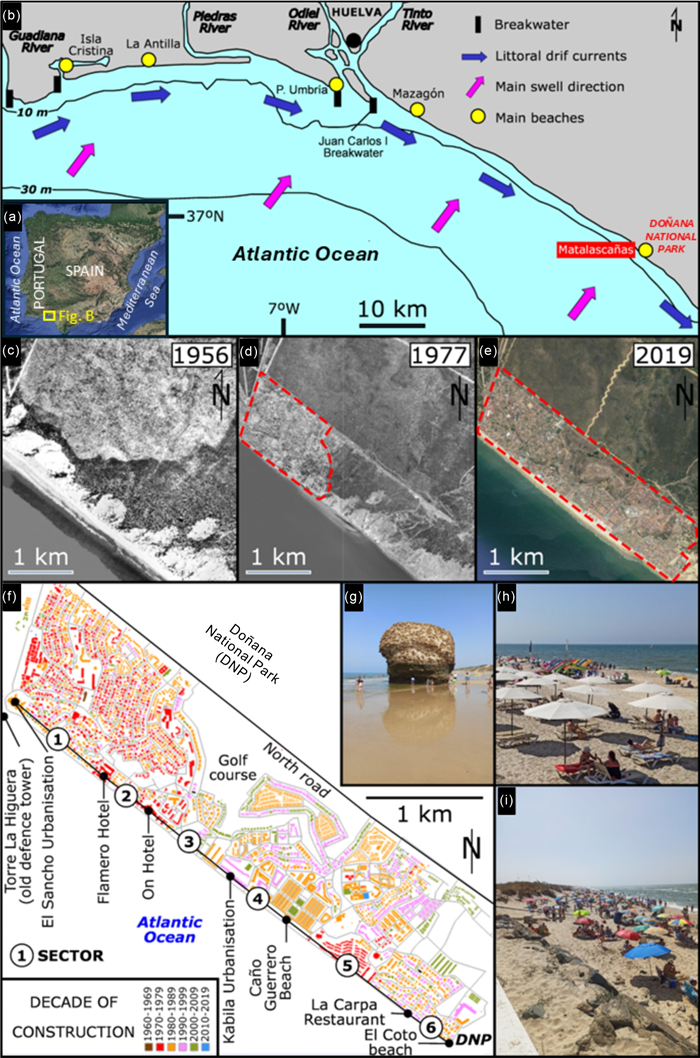
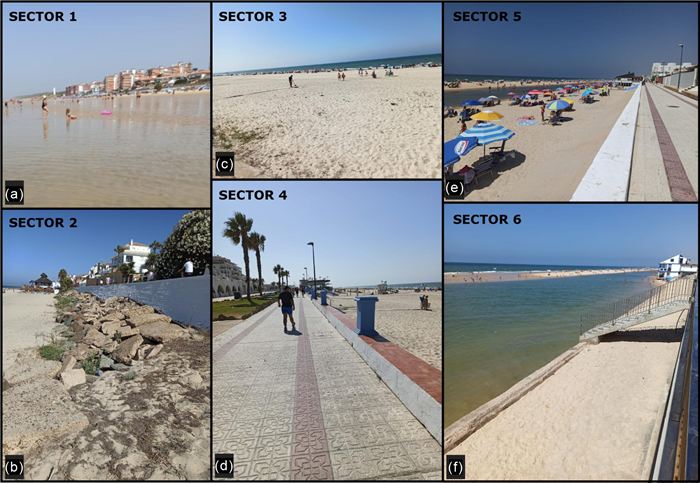
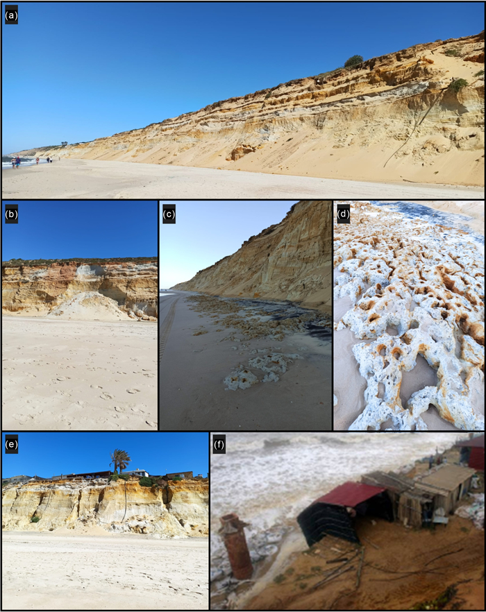
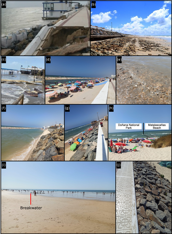
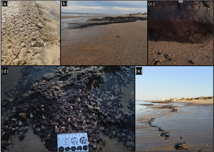
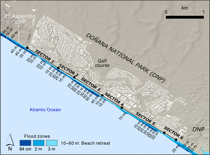
This paper analyzes the main erosive evidence identified on the Matalascañas beach (Huelva, SW Spain) and its surroundings during the years 2020 and 2021. To the northwest of this beach, the El Asperillo cliff has receded 1.5 m during this period, with the ephemeral exposure of a Pleistocene substrate with numerous paleoichnological evidence of hominids, elephants, bovids and birds. On the Matalascañas beach, the winter storms caused the partial destruction of the promenade and adjoining gastronomic establishments, as well as the exhumation of the underlying sandy substrate. In summer, the dissipative dynamics of the beach brought out a level of ostreids in its eastern sector, occupied by a temporary lagoon that completely covered the recreational bathing area. In the Doñana Park, a Biosphere Reserve, coastal erosion once again brought out a level of peat with an abundant paleoichnological record from the bioerosive action of bivalves. The historical record of this erosive evidence points to a progressive increase in its intensity during the 21th century, with a growing social pressure on the public institutions responsible for its maintenance, given the great socioeconomic impact generated by its dependence on summer tourism. In addition, the progressive sea-level rise will lead to the loss of the recreational area of this beach in the next century, as well as the need to rethink the location of its promenade and the reinforcement of the defensive structures that protect the private housing developments closest to the coastline.
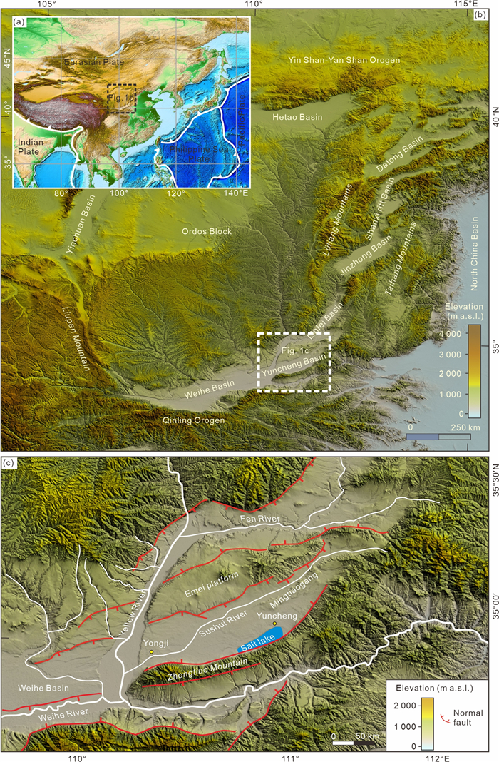
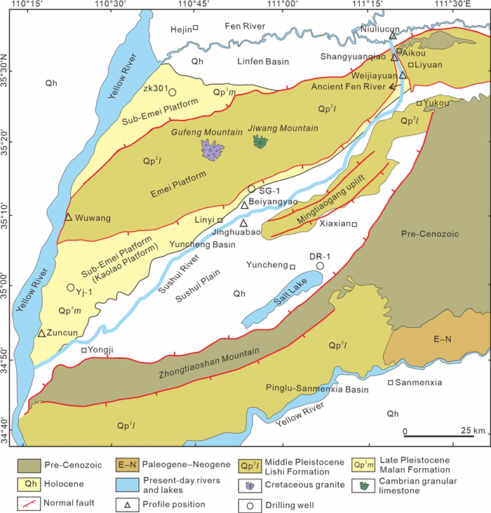
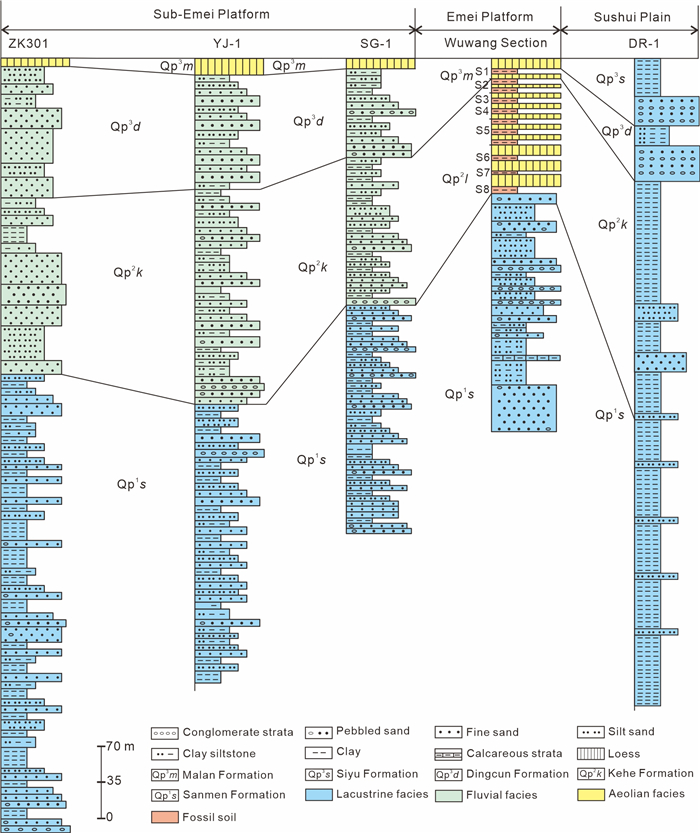
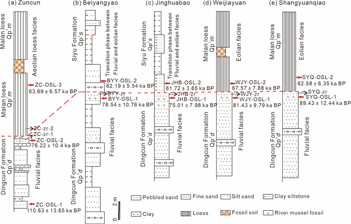
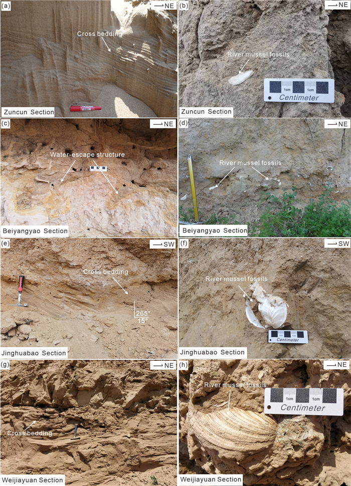
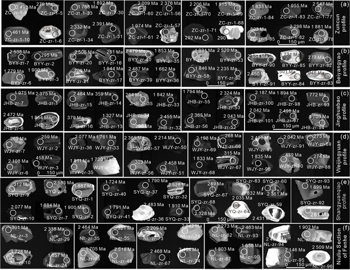
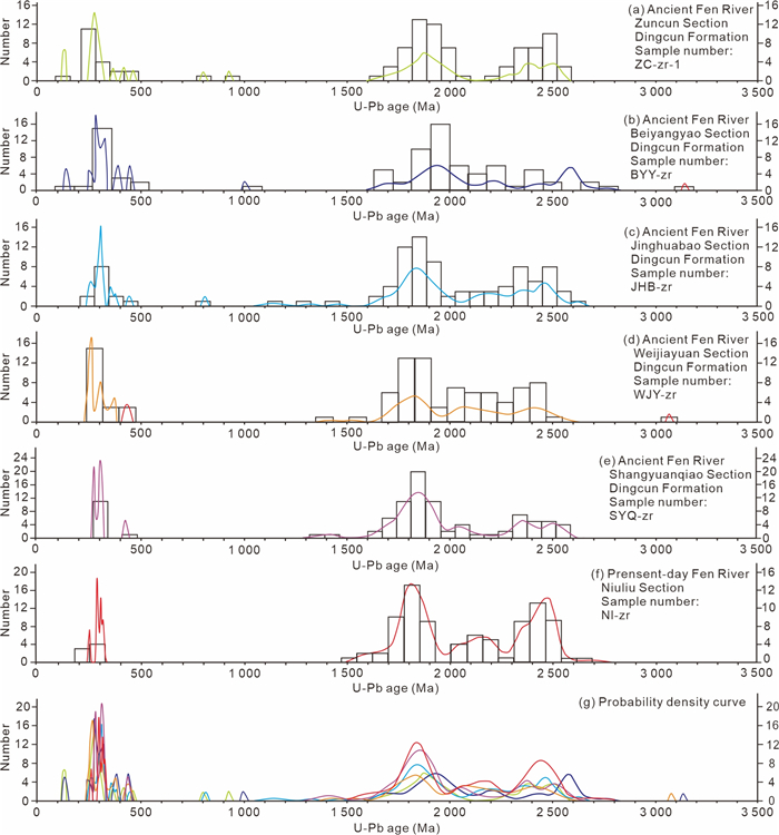
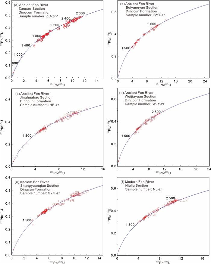
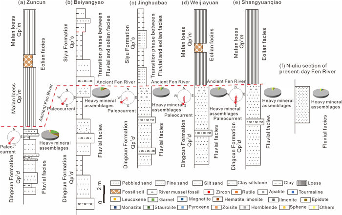
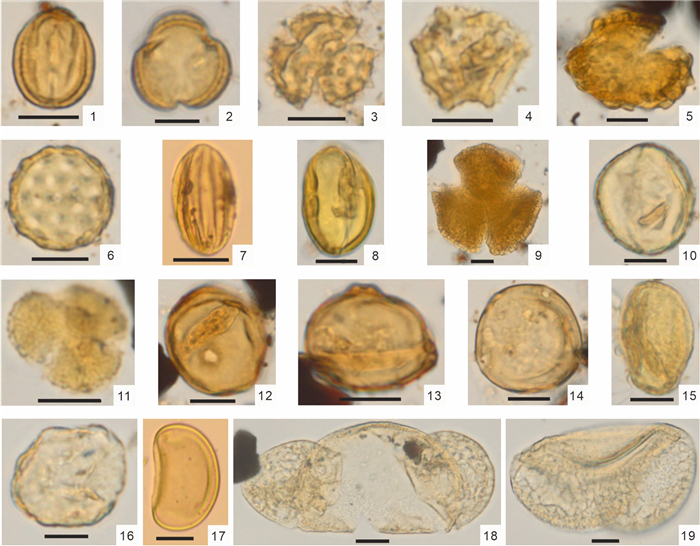
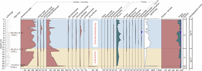
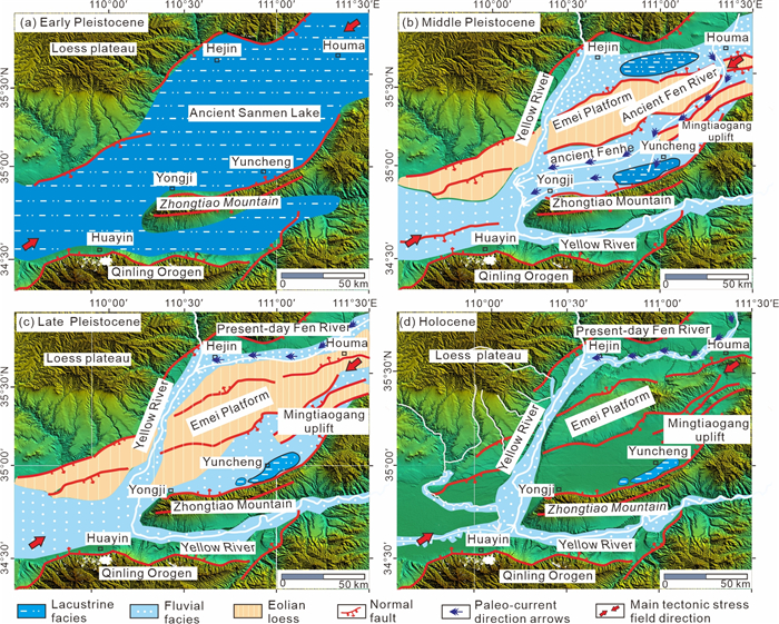
The withdrawal of the ancient Fen River from the Yuncheng Basin and its flow into the Yellow River from the present-day Linfen Basin was an important geological event in the Quaternary of the Yuncheng Basin on the southern margin of the North China Craton. There are still many controversies about whether the time frame for the withdrawal of the ancient Fen River from the Yuncheng Basin occurred in the Middle Pleistocene or the Late Pleistocene, and whether the main geological factors were the result of tectonics or climatic processes. In this paper, we use optical luminescence (OSL) dating, detrital zircon chronology, heavy mineral assemblage analysis, pollen assemblage analysis and other experimental methods to answer these controversial questions. The Late Pleistocene stratigraphic sequence in the Yuncheng Basin consists of eolian facies loess in the upper part and fluvial facies sand layers in the lower part. An unconformity, characterized by distinct lithological differences above and below, clearly indicates the timing of the ancient Fen River's disappearance. The detrital zircon U-Pb age sequence and heavy mineral assemblages of the Late Pleistocene fluvial facies sands from the ancient Fen River closely resemble those of the present-day Fen River. The unconformity between the overlying eolian loess and the underlying fluvial sands formed between 75.01 ± 7.98 and 67.57 ± 7.88 ka BP, about 70 ka BP, indicating that the ancient Fen River disappeared in the Yuncheng Basin in middle Late Pleistocene. Regional tectonic uplift led to channel realignment of the ancient Fen River, while cold and arid paleoclimatic conditions further intensified the drying of its paleochannels. This study provides new evidence to constrain the disappearance time of the ancient Fen River in the Yuncheng Basin and identifies the main geological controlling factors.
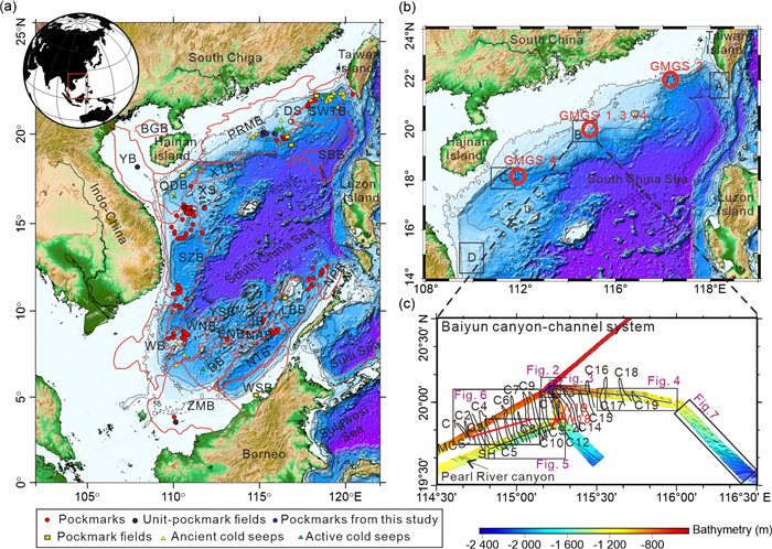
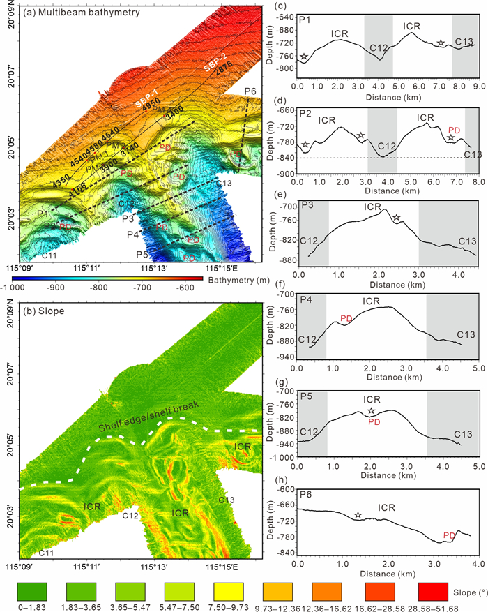
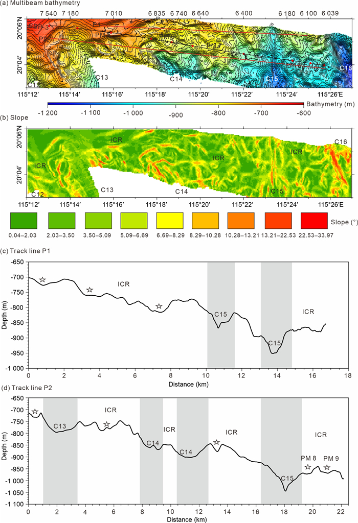
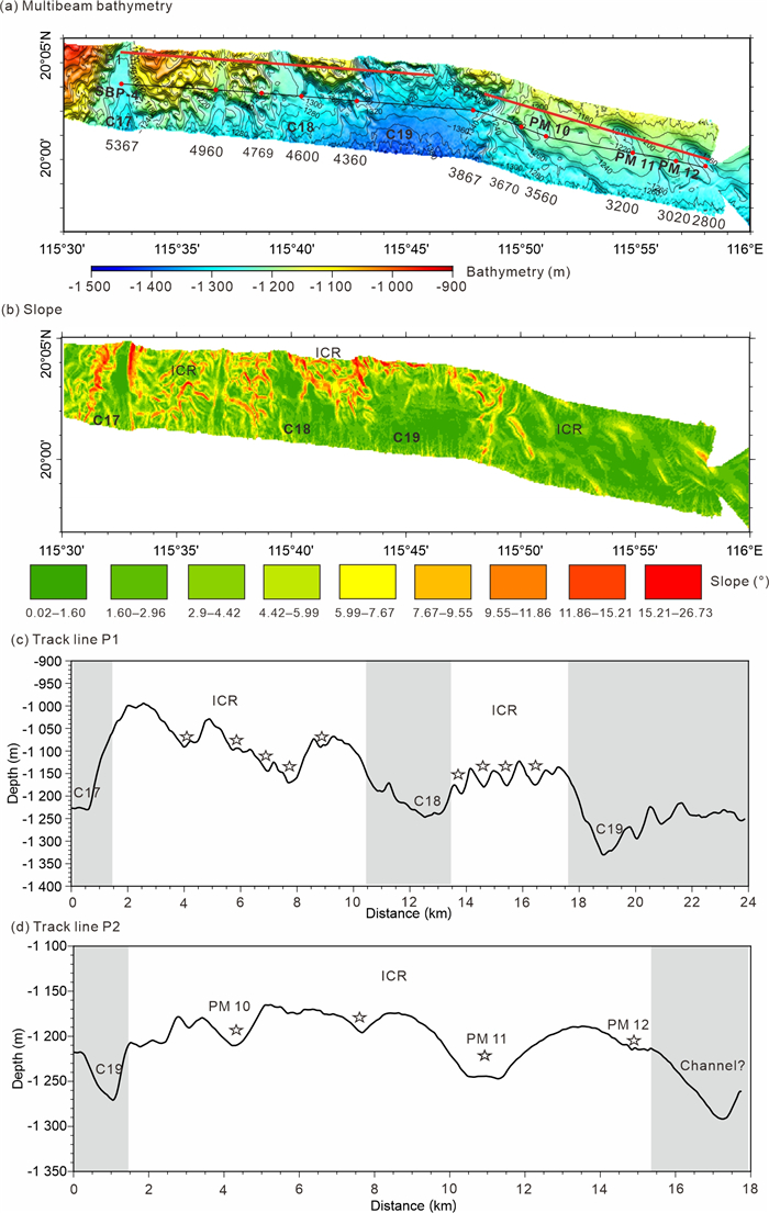
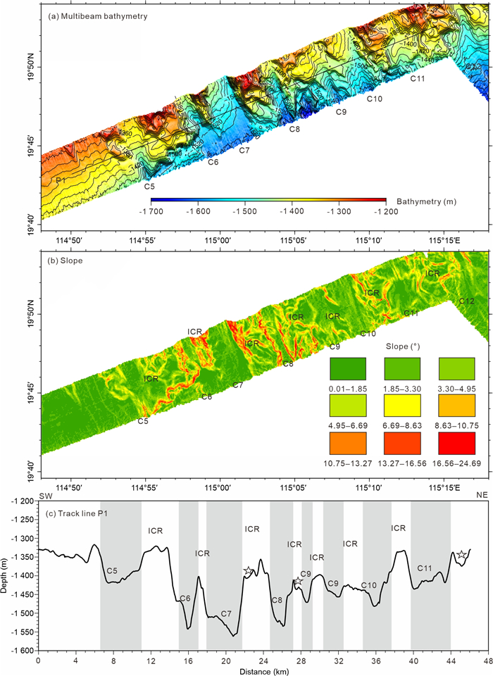
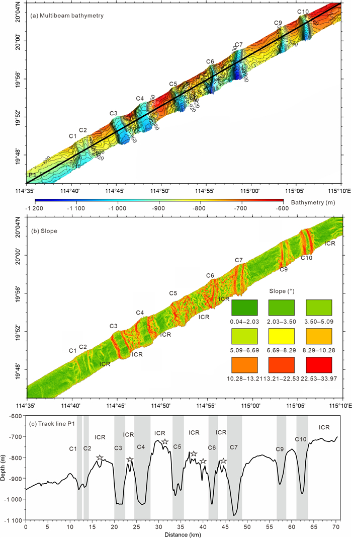
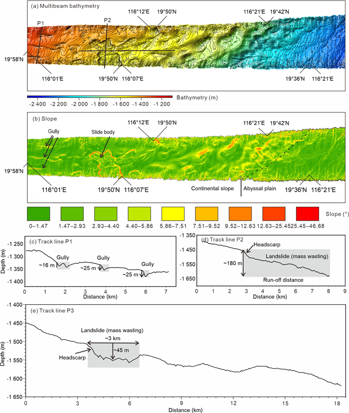
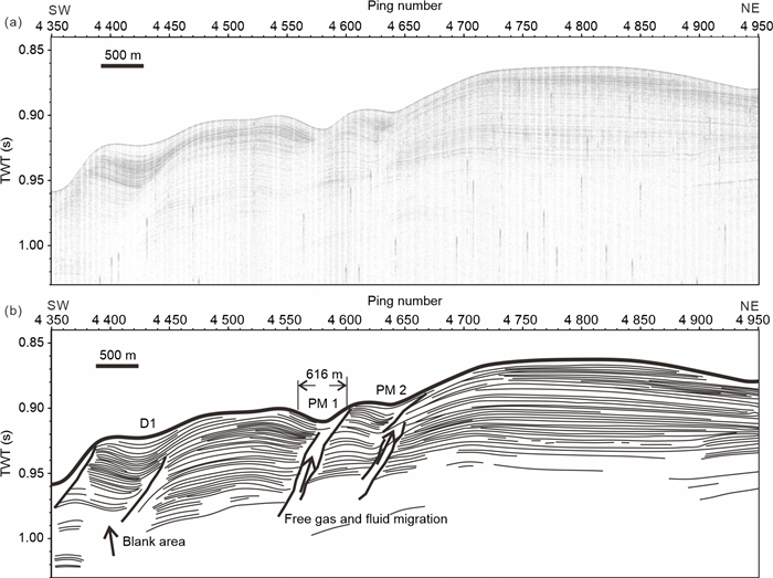
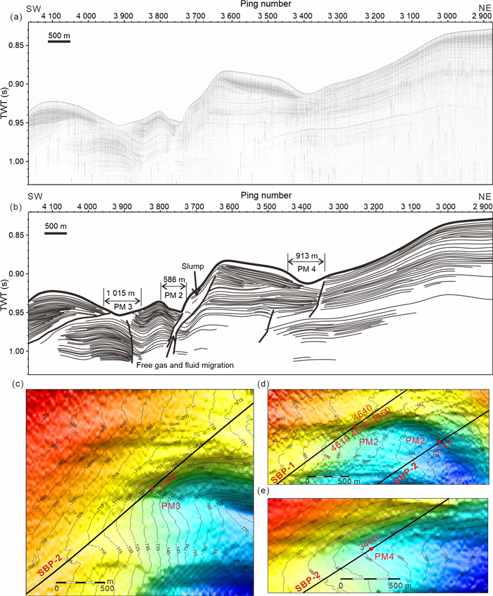
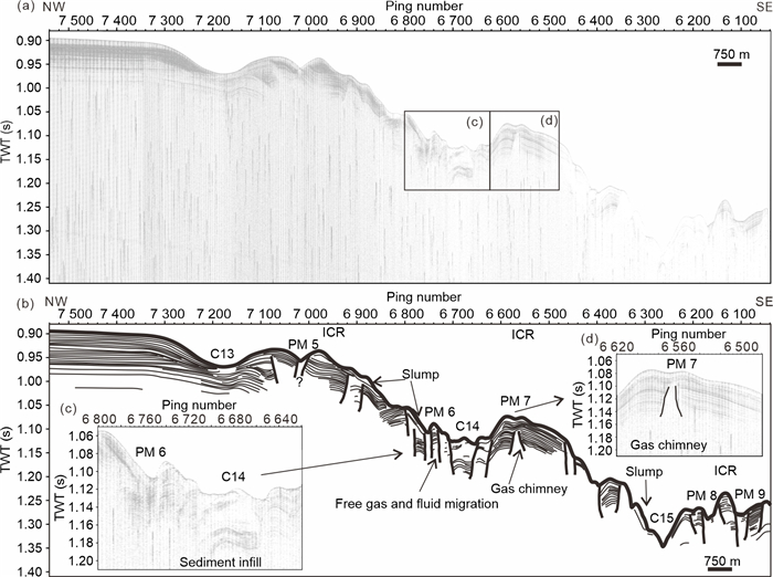
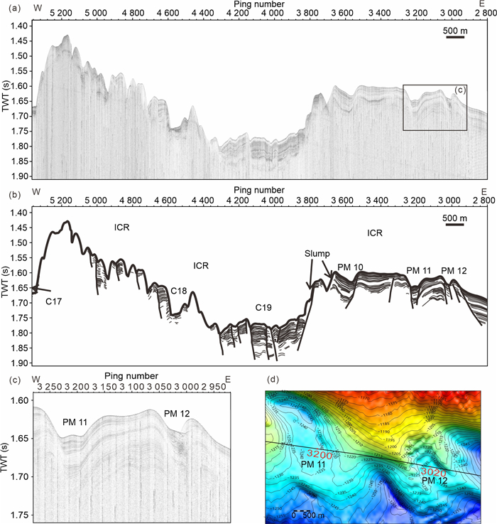
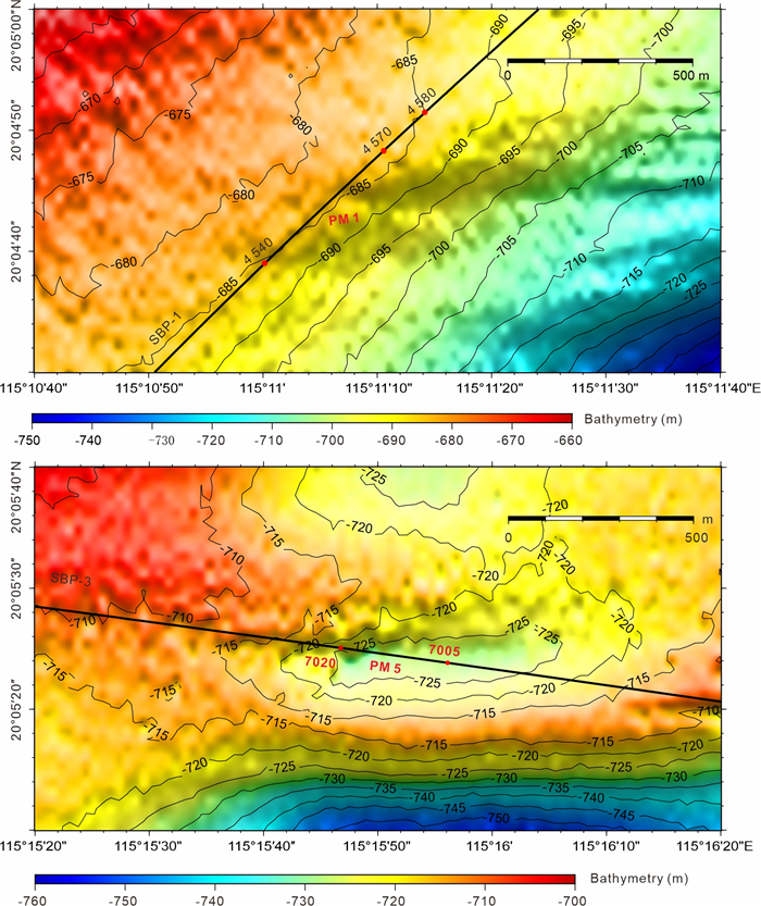
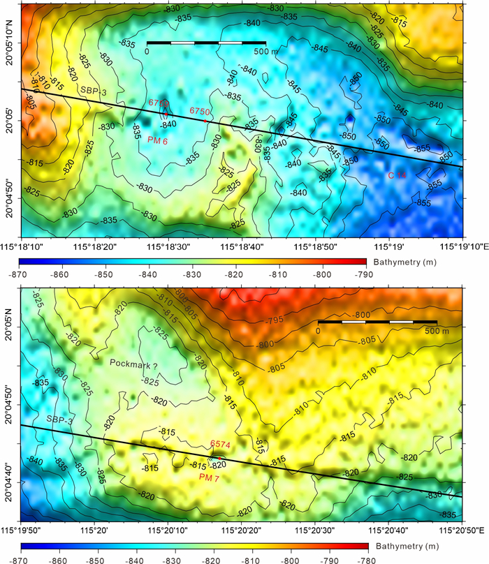
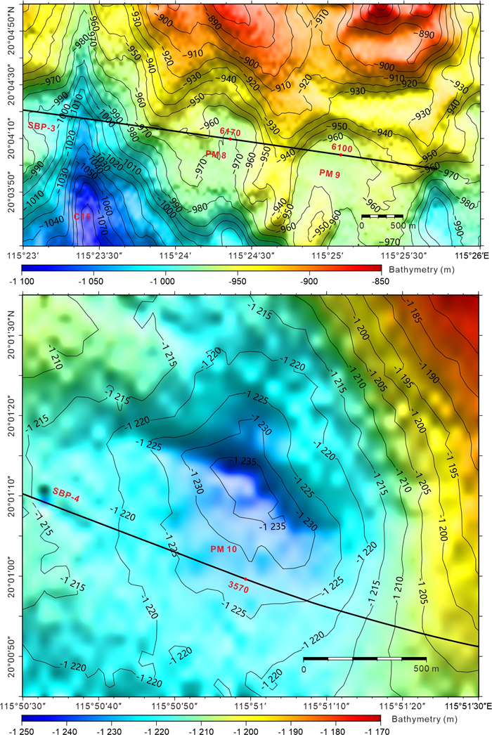
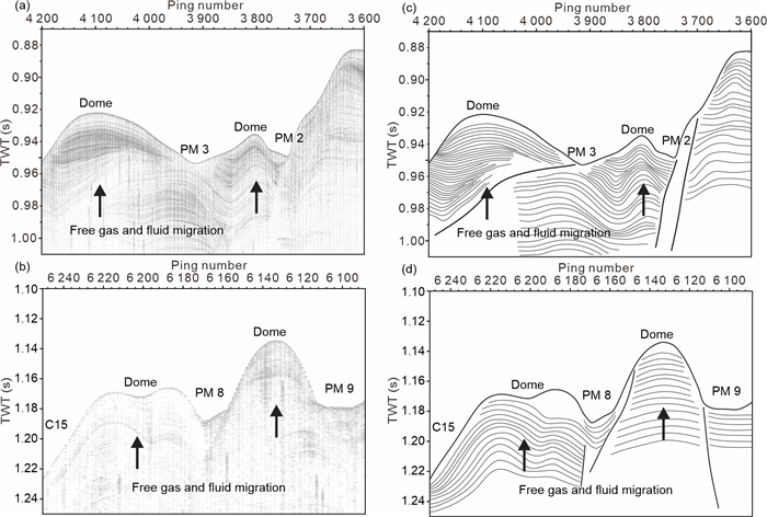
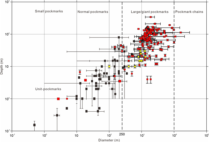
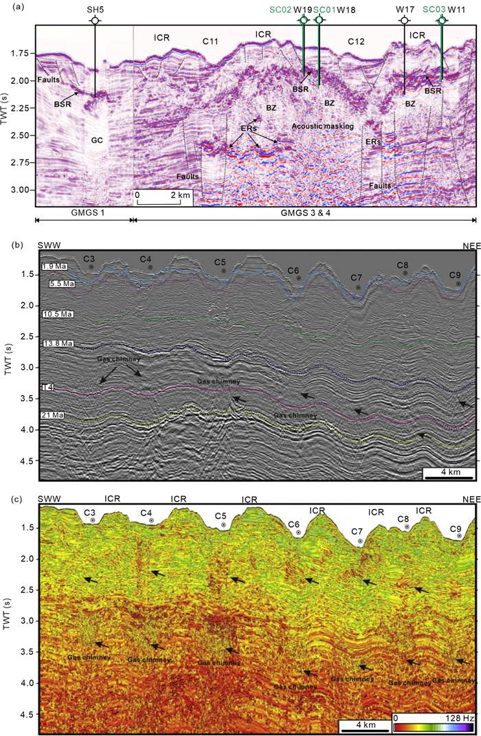
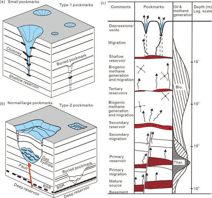
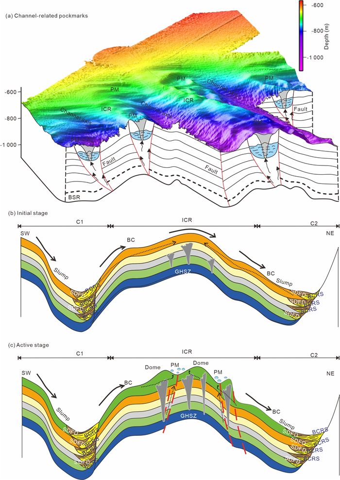
Hydrothermal vents and pockmarks in the global ocean are direct evidence for extensive seabed fluid emission and fluid seepage. Pockmarks are seafloor crater-like depressions associated with fluid escape from the seabed and are considered to contribute to the transfer of methane into the ocean and ultimately into the atmosphere. In the South China Sea, several-meters to kilometer-scale pockmarks lie in different sedimentary basins around the continental margin and are related to local subsurface structures such as mud diapirs, gas chimneys, mud volcanoes and faults. The formation of pockmarks in the Baiyun submarine channel system was accompanied with the evolution of unidirectional migrating channels in the Pear River Mouth Basin (PRMB) that produced and developed under the interaction between downslope turbidity currents and along-slope bottom currents since the Middle Miocene. Based on new acquisitioned multibeam bathymetry and sub-bottom profiler data in the Baiyun submarine channel system in the PRMB, twelve large pockmarks with 500–1 500 m long, 200–900 m wide and 10–30 m deep are recognized on the top of inter-channel ridges (ICRs) in the Baiyun submarine channel system. These pockmarks in the channel system indicate mainly circular, elliptical, crescent-shaped, elongated and horseshoe shaped in the plan view. The crescent-shaped depressions at the head part of channels and the 'pond-like' depressions between the individual channel are found and interpreted from slope variations of the bathymetry data. We proposed that channel-related pockmarks occurred at the ICRs were produced by the upward migration of overpressure gas and fluid along gas chimneys and faults caused by the gas hydrate dissolution in the deep reservoirs since the Middle Miocene and the ICRs underwent the collapse and erosion process by bottom currents in the shallow part. The sources of fluid and gas induced to the formation of pockmarks are from deep to shallow reservoirs in the submarine channel system.
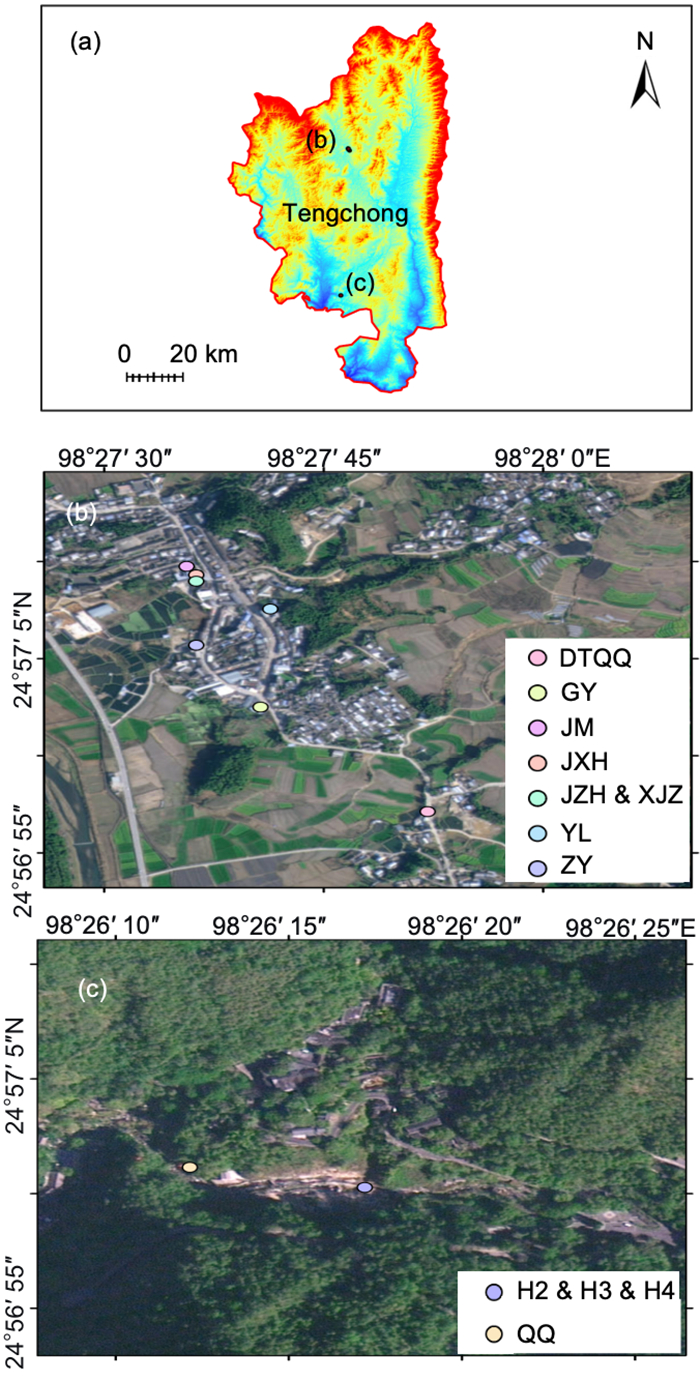
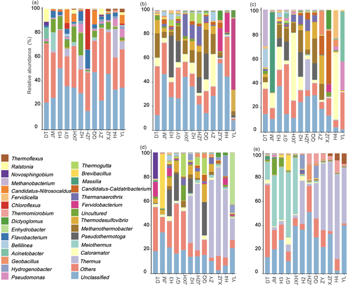
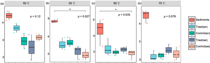
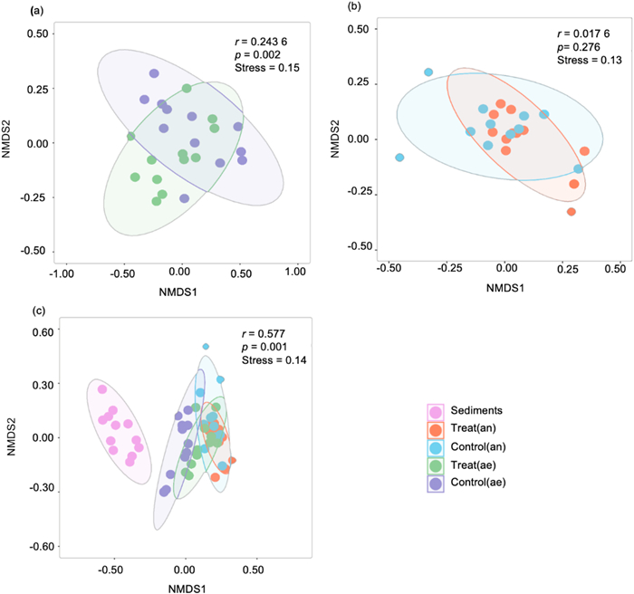
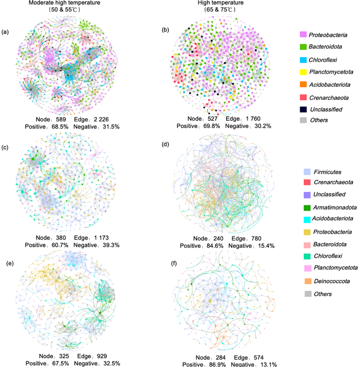
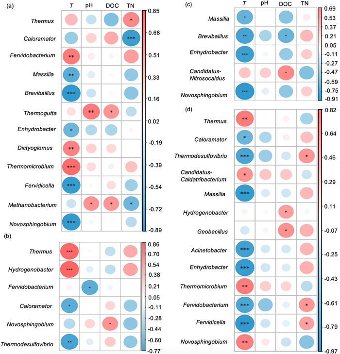
Thermophilic microbial communities in hot springs represent a promising yet underexplored resource for high-temperature sludge degradation. This study investigated the structural dynamics and temperature-adaptive mechanisms of microbial communities in Tengchong hot springs using waste activated sludge (WAS) as the carbon/nitrogen source. Through anaerobic/aerobic enrichments at 50–75 ℃, high-throughput 16S rRNA gene sequencing revealed distinct thermophilic assemblages:
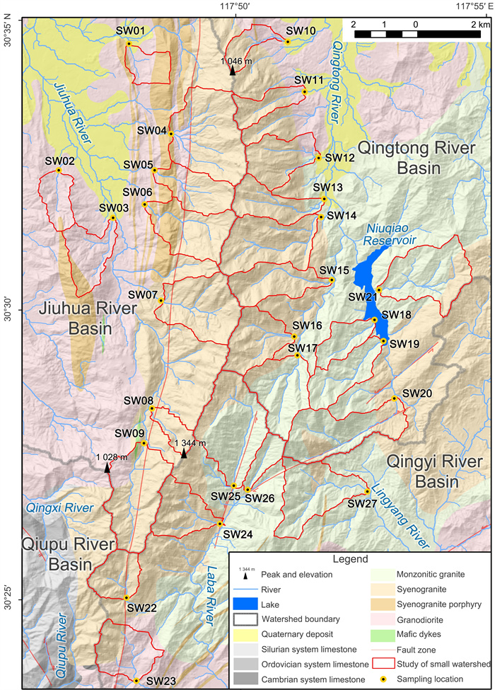
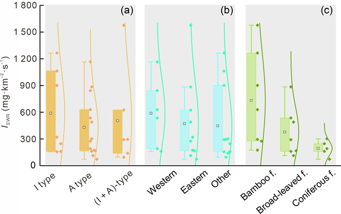
Granite mountainous regions not only exhibit stunning natural landscapes but also play a vital role in the terrestrial carbon cycle. The Silicate Weathering Rates (SWR) serves as a critical factor influencing both landscape formation and carbon consumption. The common method of estimating the watershed SWR by combining the ion flux at watershed outlets with average annual runoff depth does not consider geological-vegetation effects and cannot accurately reflect the actual weathering rate in small watersheds. This study, based on the typical granite geomorphic landscape of Jiuhuashan in eastern China, refines the classification of granite types and vegetation distributions in the region. The chemical composition and instantaneous flow rate of river water in 27 small granite watersheds in Jiuhuashan are systematically measured, thereby the Instantaneous Silicate Weathering Rate (
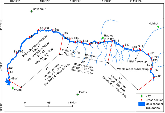
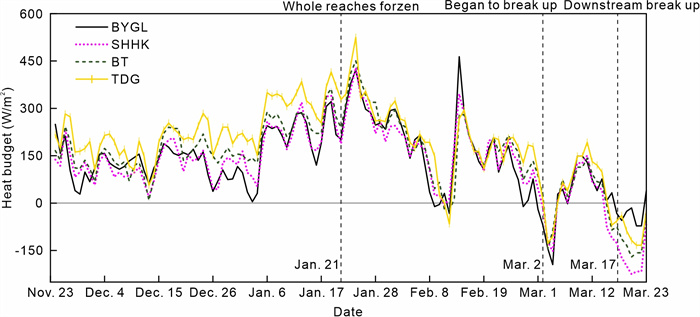
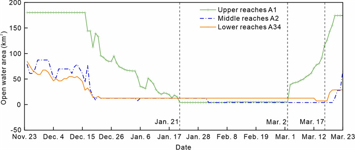
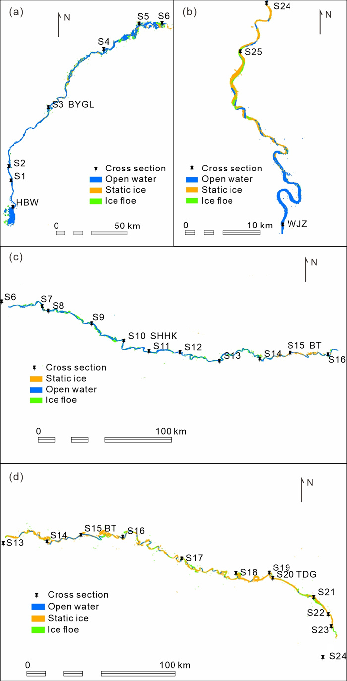
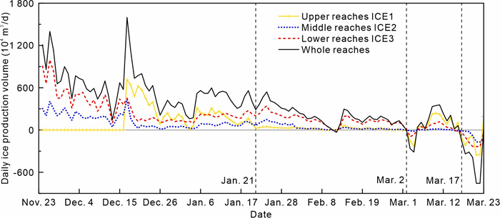
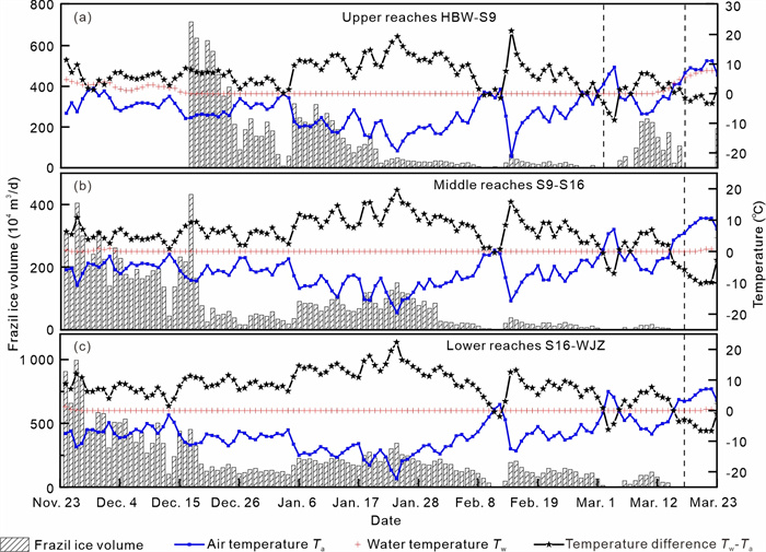
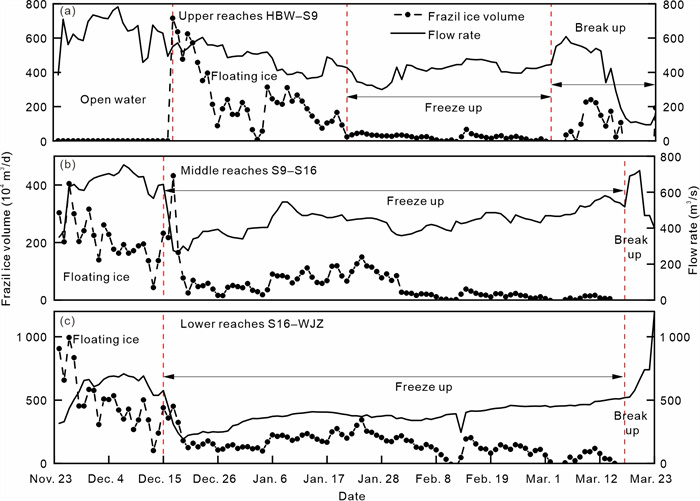
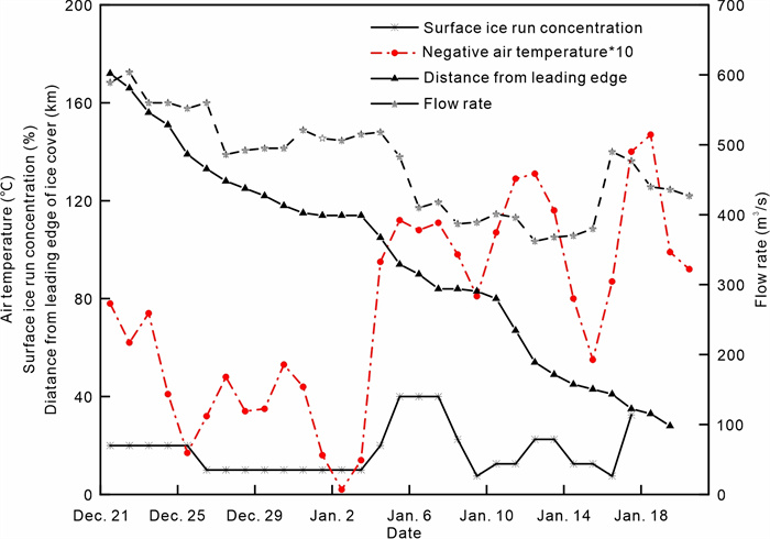
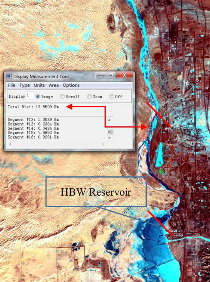
In this study, frazil ice production and its influencing factors in the Inner Mongolian reaches of the Yellow River were revealed. The reach extending from the Haibowan Reservoir (HBW) to the Wanjiazhai Reservoir (WJZ) was chosen as the research area for this study, because this section frequently experiences serious ice-related problems. Frazil ice production rate is important for ice cover progression and hanging dam formation, which affect ice conditions and reservoir operation. The heat exchange between the water surface and the atmosphere and the variation in the water surface area are the main factors affecting frazil ice production. A linear heat budget model was used in this study, and a simplified model was proposed for effective open-water area estimation. The results show that the quantity of heat budget upstream and downstream determines the order of freeze-up and break-up. The surface ice appeared when the difference between the water temperature and air temperature was between 6 and 8 ℃. The daily open water area could be estimated on the basis of the ice run concentration and the length of freeze-up, with an error rate of less than 13% compared with the remote sensing monitoring results. Thermal discharge from the HBW delays frazil ice formation and the freeze-up date, resulting in a 13.85 km long stretch of open water downstream of the reservoir and reducing daily frazil ice production by at least 2.31 × 10⁵ m3.
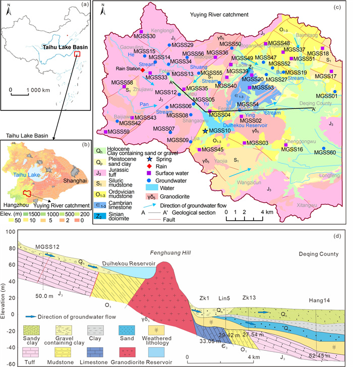
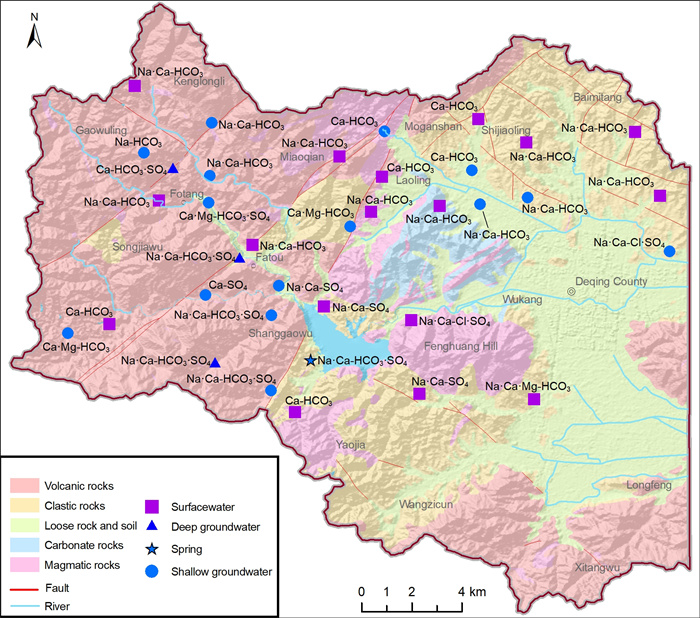
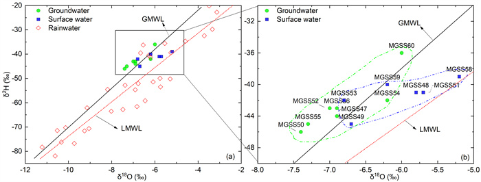
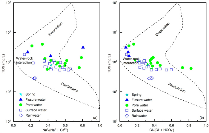
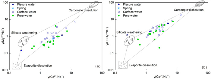
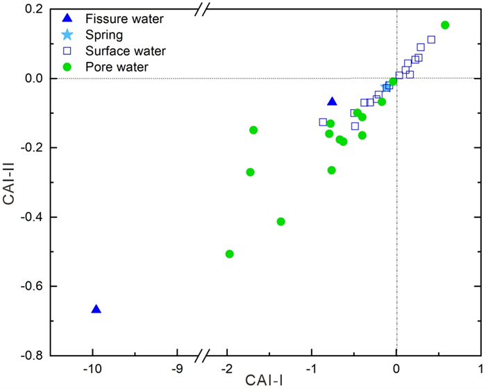
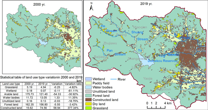
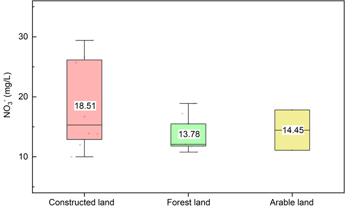
The Yuying River catchment, a hilly watershed serving as a critical drinking water source for Taihu Lake, exhibits hydrogeochemical characteristics essential to regional water supply safety. To assess potential risks to Taihu Lake, this study collected rainwater, surface water, and groundwater samples from the catchment for comprehensive hydrochemical analysis, including isotopic measurements of δ2H, δ18O, and 3H. Results revealed that groundwater hydrochemical types were predominantly HCO3·SO4-Na·Ca and HCO3-Na·Ca. Groundwater renewal rates in the catchment ranged from 34% to 44% annually, suggesting accelerated recharge processes. Hydrochemical evolution was primarily governed by cation exchange and silicate weathering-driven leaching. Historical data indicated a sharp rise in groundwater NO3- concentrations from 4.7 mg/L (2000) to 15.8 mg/L (2019), coinciding with a 377.34% expansion in constructed land area. Both metrics increased approximately threefold since 2000. Principal Component Analysis (PCA) of nitrate sources under different land-use types identified domestic sewage discharge as the dominant contributor to anomalous NO3- elevation. These findings imply that intensified anthropogenic activities—particularly unscientific sewage disposal—have surpassed the catchment's self-purification capacity. Urgent implementation of scientifically validated wastewater treatment strategies is imperative to safeguard the water environment and ecological security of both the Yuying River catchment and downstream Taihu Lake.


ISSN 1674-487X
CN 42-1788/P
Editor in Chief: Yanxin Wang
Executive Editors in Chief: Zhong-Qiang Chen, Jiang Shaoyong
Associate Editor:
Shu Jiang,Changdong Li,Rui Ma
Qiliang Sun,Timothy M. Kusky,Dun Wang
Lunche Wang,Long Xiao,Xin-Fu Zhao
Keqing Zong,Renguang Zuo ,Zongjun Yin
2024 Impact Factor 4.7, JCR Q1
JES Citing RankingMore +
- 1Seawater Temperature and Dissolved Oxygen over the Past 500 Million Years
- 2Inventory and Spatial Distribution of Landslides Triggered by the 8th August 2017 MW 6.5 Jiuzhaigou Earthquake, China
- 3Geological Evidence for the Operation of Plate Tectonics throughout the Archean: Records from Archean Paleo-Plate Boundaries
- 4Proto-South China Sea Plate Tectonics Using Subducted Slab Constraints from Tomography
- 5An Optimized Random Forest Model and Its Generalization Ability in Landslide Susceptibility Mapping:Application in Two Areas of Three Gorges Reservoir, China
- 1Dynamic Hydromechanical Behavior of Reservoir Slopes: Seepage and Deformation under Variable Water Level Drawdown
- 2Automatic Stitching Method for Chang'E-2 CCD Images of the Moon
- 3Radial anisotropy in the crust beneath the northeastern Tibetan Plateau from ambient noise tomography
- 4Spatial Variation of Hydraulic Conductivity Categories in a Highly Heterogeneous Aquifer: A Case Study in the North China Plain (NCP)
- 5On the Numerical Modeling of the Deep Mantle Water Cycle in Global-Scale Mantle Dynamics: The Effects of the Water Solubility Limit of Lower Mantle Minerals
- 1Sedimentary Characteristics and Reservoir Prediction of Paleogene in the East Part of Kuqa Foreland Basin
- 2Chemical Composition of Urban Street Sediments and Its Sources
- 3Rainfall Threshold Calculation Method for Debris Flow Pre-Warning in Data-Poor Areas
- 4Hydrocarbon Distribution and Accumulation Model in the South of Lixian Slope, Raoyang Subbasin
- 5Deepwater Canyons Reworked by Bottom Currents: Sedimentary Evolution and Genetic Model
Recommended IssuesMore +
- Satellite remote sensing monitoring and its applications in major engineering projects
- Continental Margins of East and Southeast Asia: Sedimentology, Geomorphology, and Climate change Special Issue in The Journal of Earth Science
- Notice on Collecting “Top 70 Questions Facing Earth Science”
- Call for papers for a special issue of Journal of Earth Science: on Sustainable Technologies for Earth Science and Climate Change
- Tropical Large Benthic Foraminifera: Adaption, Extinction, and Radiation


