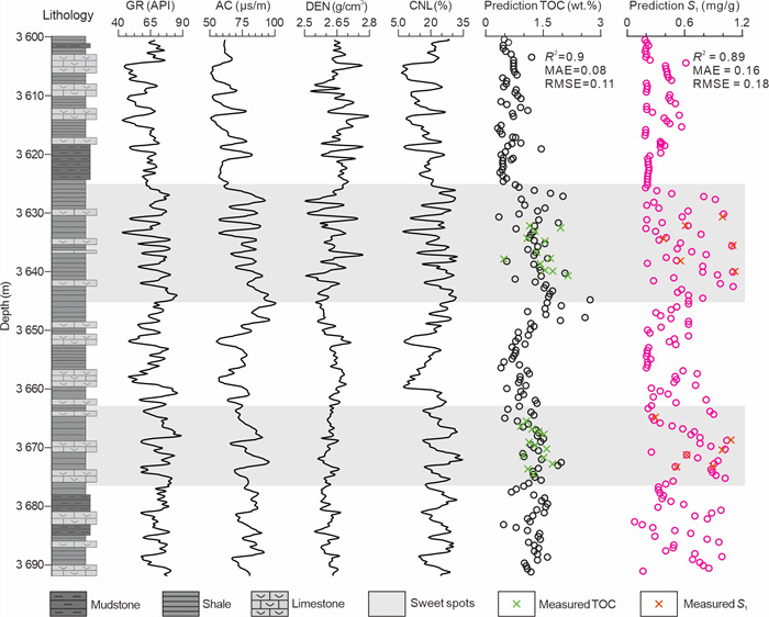
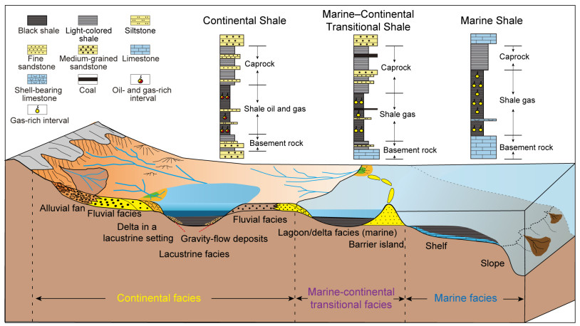
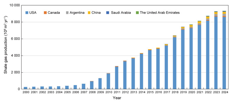
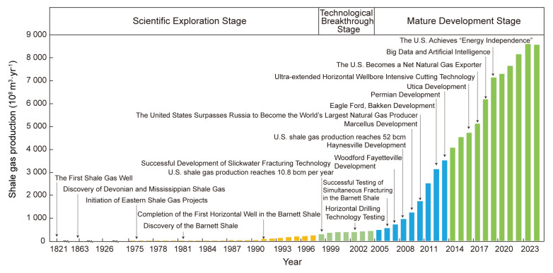
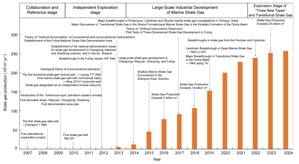
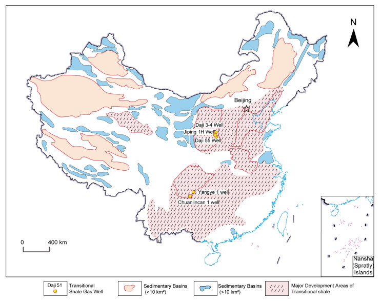
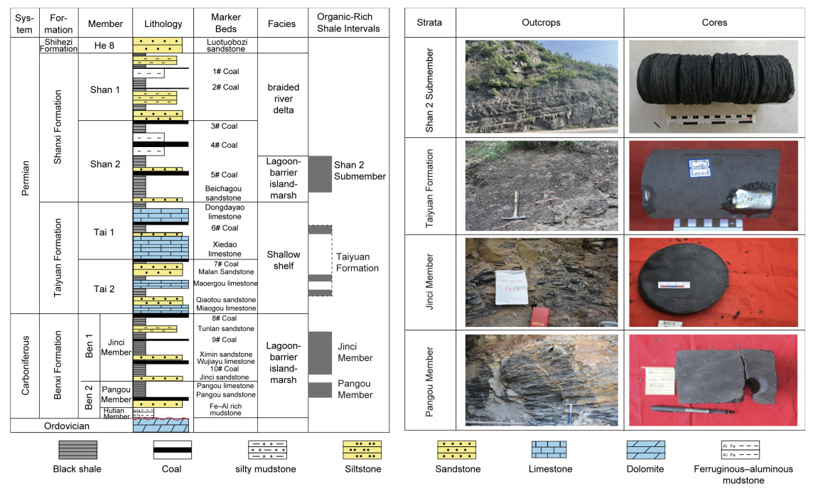
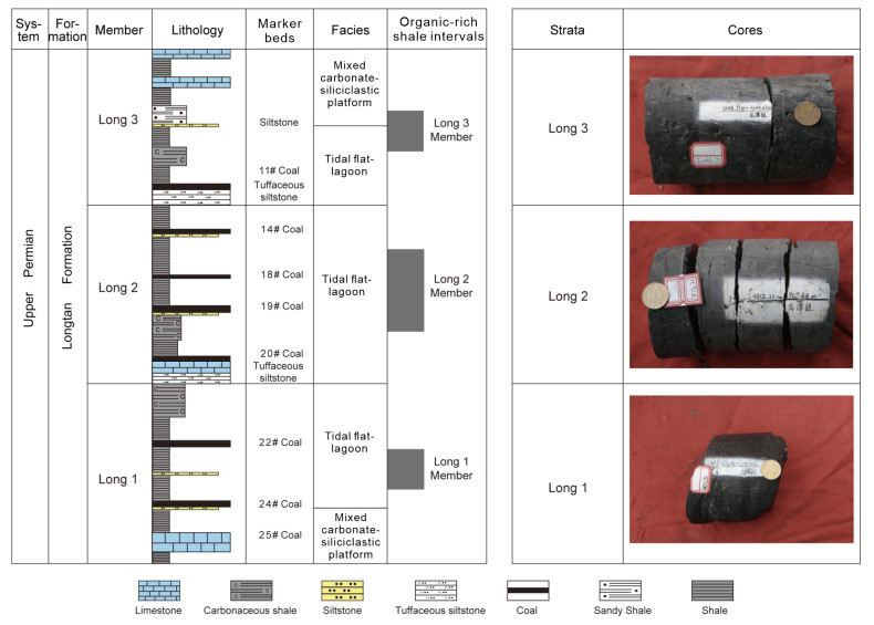
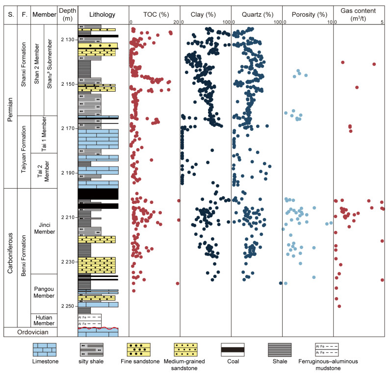
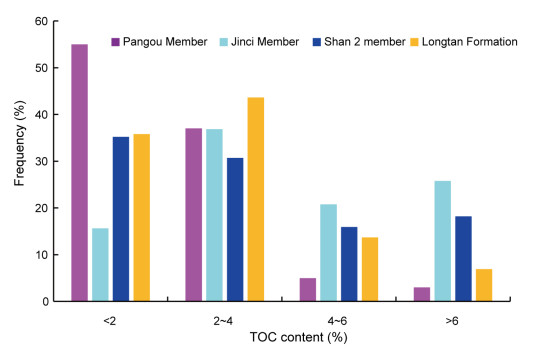
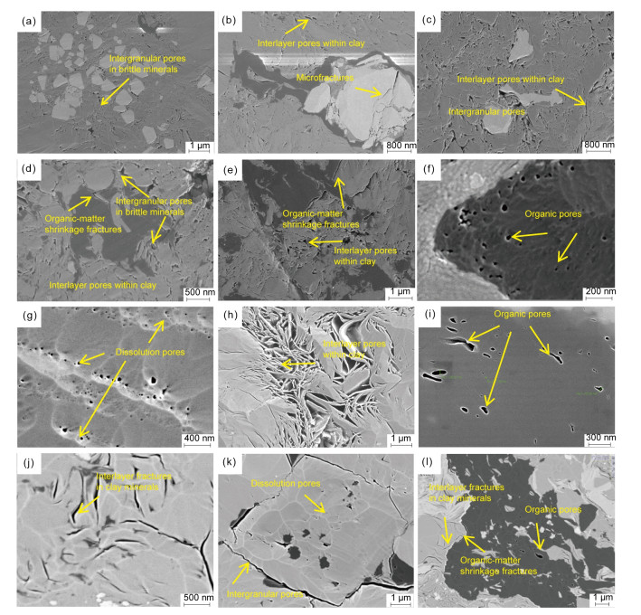
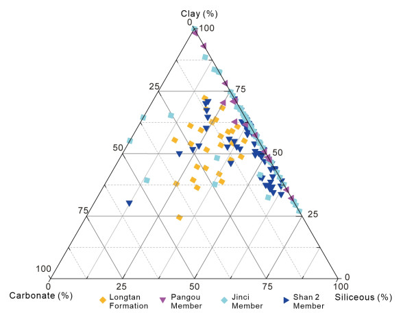
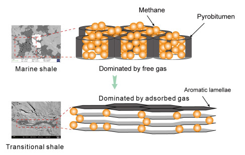
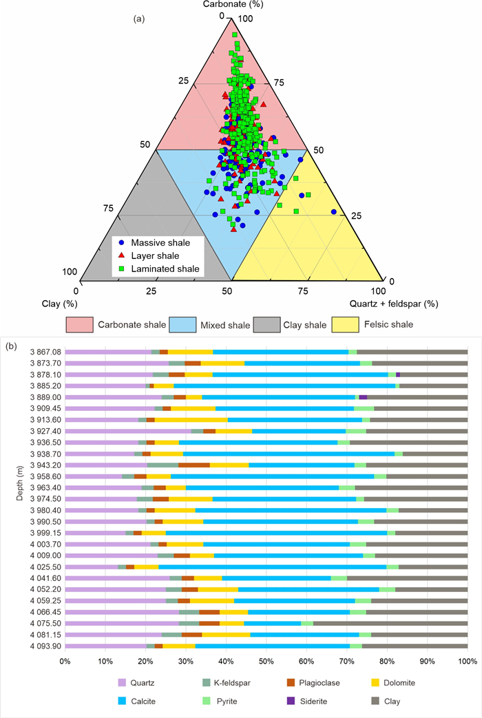
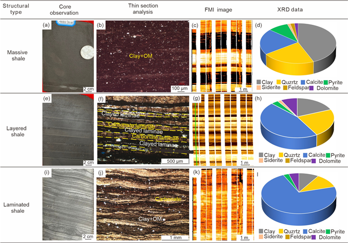
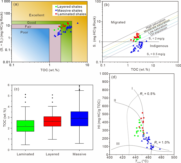
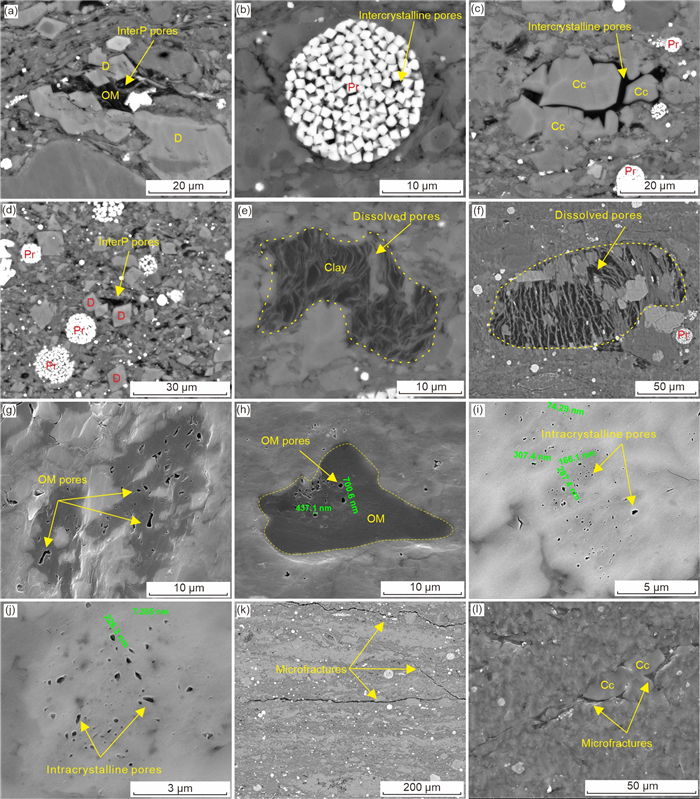
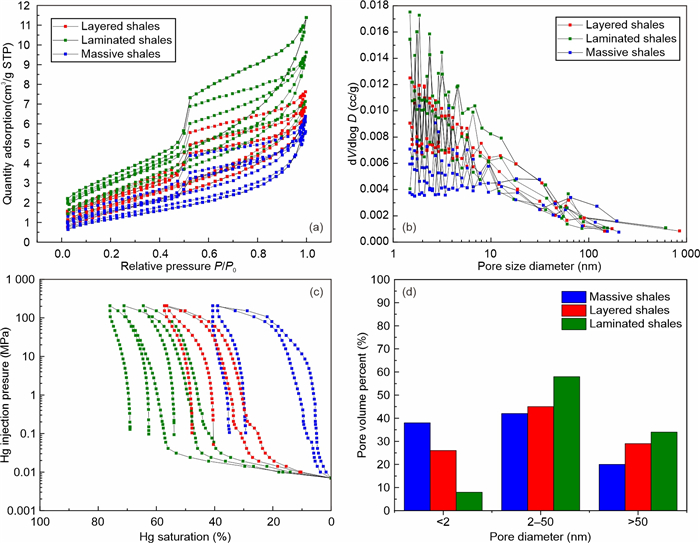
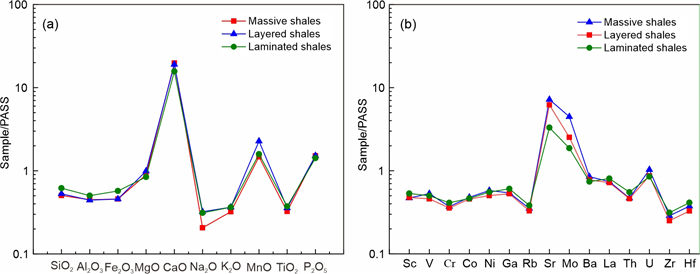
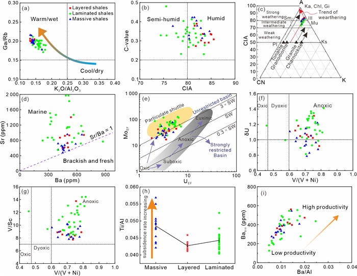
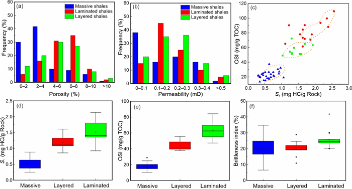
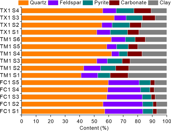
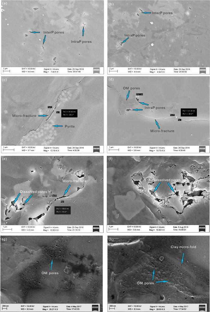
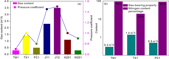
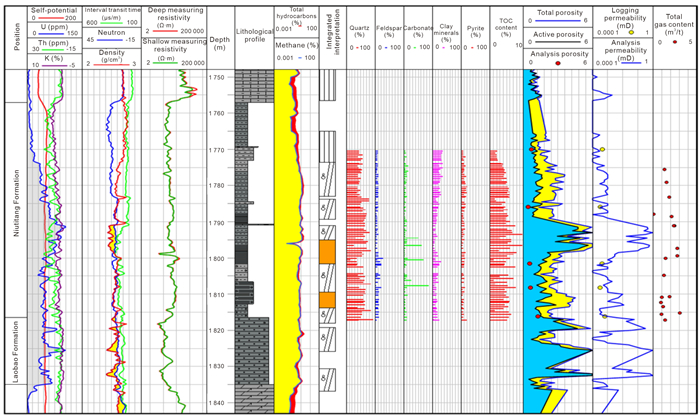
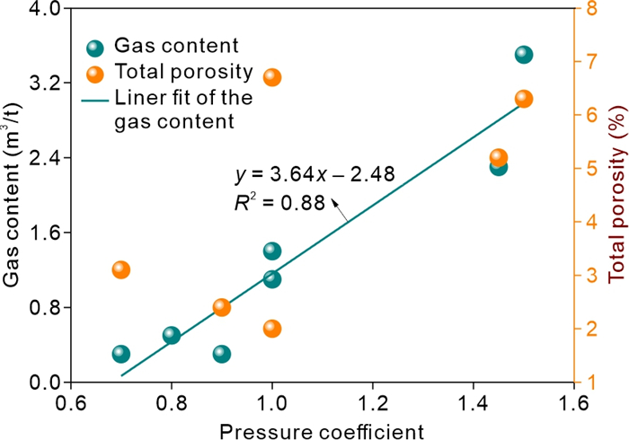
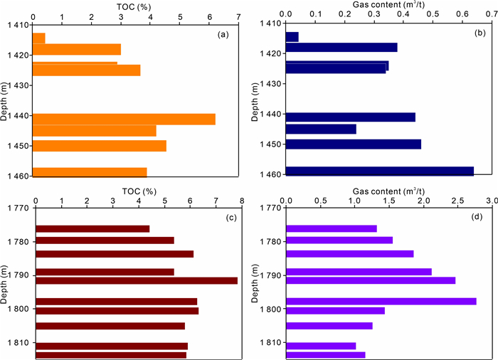
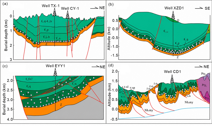
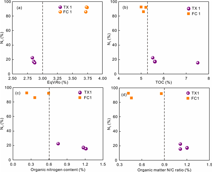
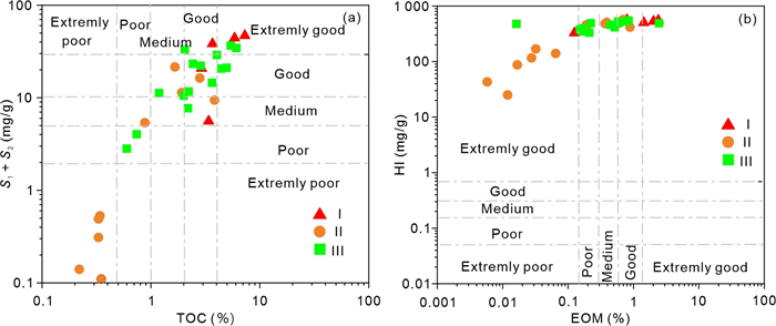
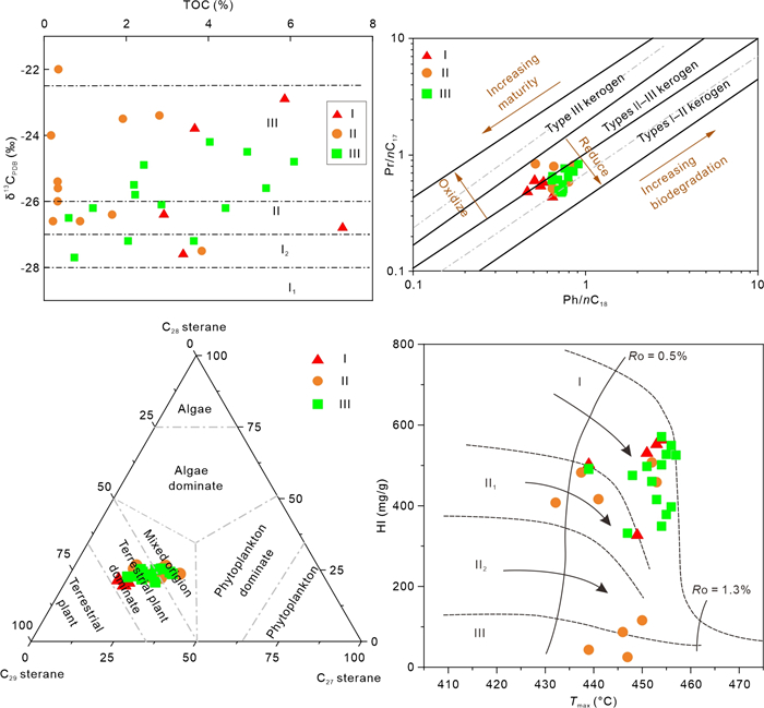
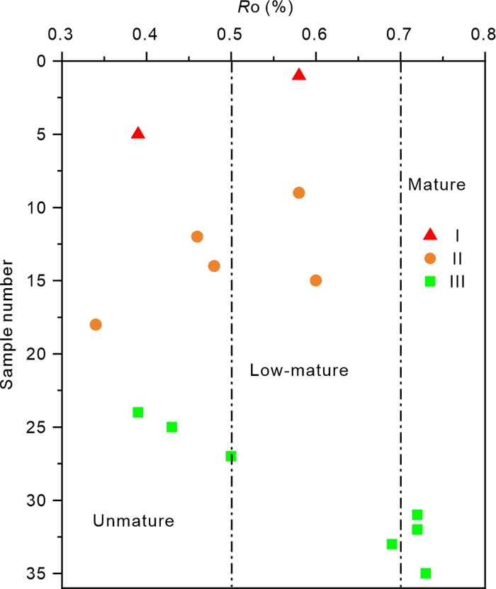
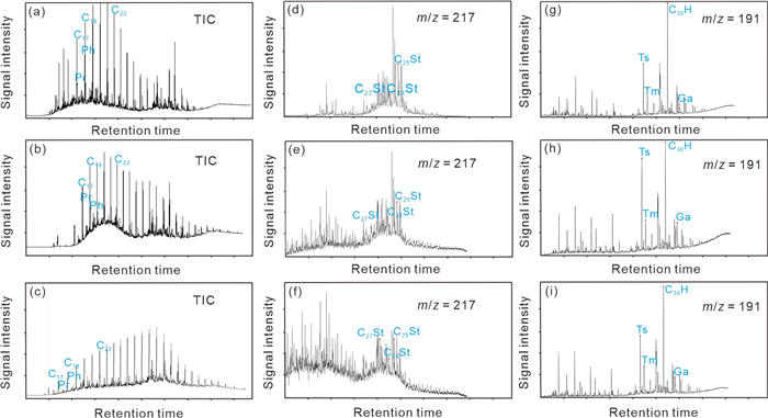
Current Issue

2024, Volume 35,  Issue 2

COVER
2024, 35(2): .
Abstract:
CONTENTS
2024, 35(2): .
Abstract:
Stratigraphy and Sedimentology
Early Triassic Legoupil Formation in Schmidt Peninsula, Antarctic Peninsula: Provenance and Depositional Settings
Chao Zhang, Ying-Chun Cui, Chen-Guang Liu, Fang-Hua Cui, Lu-Yuan Wang, Wei-Qiang Zhang
2024, 35(2): 317-331. doi: 10.1007/s12583-021-1601-1
Abstract:

Geochemical compositions can be used to determine the tectonic setting of sedimentary basins, while where the link of source to sink is no longer preserved, detrital zircon age patterns can aid in resolving the original basin setting. The metasedimentary Legoupil Formation, located at Cape Legoupil and the Schmidt Peninsula, could give a hint for the tectonic evolution of Antarctic Peninsula. In this contribution, we constrain the sedimentary provenance of the Legoupil Formation through geochemistry and detrital zircon U-Pb geochronology. The petrography and geochemical features indicate that the provenance of the Legoupil Formation could be felsic rocks. Detrital zircon grains record a steady supply of Permian and Ordovician material into the Legoupil Formation. The youngest concordant zircon ages of 262 Ma suggest that the depositional time of Legoupil Formation is no older than Late Permian. The detrital zircon age spectrum of Legoupil Formation suggests that the Legoupil Formation sediments should be derived from regional sources endemic to western Gondwana prior to its breakup. Together with the previous studies, geochemistry and detrital zircons reflect an active continental margin tectonic setting and the detrital zircon spectra of Legoupil Formation are similar to the ones deposited in forearc tectonic setting.

Depositional and Bio-Sequence Stratigraphic Framework of Late Cretaceous Kawagarh Formation, Kala-Chitta Range, Pakistan: Equivalent of Gurpi Formation (Iran)
Muhammad Awais, Bilal Wadood, Muhammad Ishaq, Muhammad Bilal, Zeeshan Zafar, Nasar Khan, Aminullah Khan
2024, 35(2): 332-348. doi: 10.1007/s12583-022-1703-4
Abstract:

The present study is focused on evaluation of deep marine pelagic sediments of Late Cretaceous Kawagarh Formation of Kala-Chitta Range in the context of microfacies analysis, paleoenvironmental interpretation, planktonic foraminiferal biostratigraphy, sequence stratigraphy and diversification of species. A total of thirty three rock samples were collected from the measured section. Three microfacies are interpreted, namely planktonic foraminifera wackestone, planktonic foraminifera mudstone and sandy mudstone indicating low energy depositional environment i.e., outer ramp. The biostratigraphic studies show plentiful planktonic foraminifera species of Globotruncana, Heterohelix and Globotruncanita. However, no association of benthic or siliceous organisms was observed. On the basis of available species assemblage, a single local planktonic foraminifera biozone i.e., Globotruncana-Heterohelix-Globotruncanita Assemblage Biozone is established. The biozone information is combined with published literature and Lower Santonian to Middle Maastrichtian age has been assigned to the Kawagarh Formation. The trend of species occurrences evinces that species number decreases over time with pulsated rise in the Kawagarh Formation. The Kawagarh Formation carbonates show an overall Transgressive Systems Tract (TST). The Kawagarh Formation of Pakistan evinces analogous characteristics to that of the Late Cretaceous Gurpi Formation of Iran based on the geologic age, outcrop lithology, microfacies, planktonic foraminiferal assemblages, depositional setting and sequence stratigraphy.

Multi-Elemental Chemostratigraphy, Sequence Development, Depositional History, and Environmental Importance of Early Eocene Red Beds (Kuldana Formation) in NW Himalayas, Pakistan
Amir Shahzad, George Kontakiotis, Thierry Adatte, Khawaja Shoaib Ahmed, Muhammad Tayyib Riaz, Hammad Tariq Janjuhah, Evangelia Besiou
2024, 35(2): 349-375. doi: 10.1007/s12583-023-1860-6
Abstract:

The Eocene Kuldana Formation (KF) in the Yadgar area of Pakistan, comprises a diverse range of sedimentary facies, including variegated red beds of shales, mudstones, and sandstones, as well as interbedded limestone and marl. In this study, we conducted an integrated micropaleontological, sedimentological, mineralogical, and geochemical investigation to determine the depositional setting, biochronology, provenance, and paleoclimate of the KF. The study identified six lithofacies and six microfacies, which indicate a variety of environments ranging from floodplains and channels to the margins and shallow marine settings. The nannofossil biostratigraphy places the KF in the Early Eocene, more precisely the NP10 zone (Ypresian), and the fossil zone of benthic foraminifera classifies the study section as the Shallow Benthic Zone SBZ-8 (Middle Ilerdian 2). In terms of petrography, the KF sandstone was classified as litharenite and feldspathic litharenite, while the QtFL diagram suggests a recycled orogen. Geochemical proxies indicate an oxidizing environment, a high-to-low regular sedimentation rate, moderate-to-intense chemical weathering in the source region, and a warm-humid to dry climate during the deposition of KF. Overall, the findings suggest that the deposition of KF marks the end of Neo-Tethys due to the Early Eocene Indian–Kohistan collision and that the uplifting of the Himalayas provided the source for the deposition of KF in the foreland basin. The study provides new insights into the depositional environment, biochronology, provenance, and paleoclimate of KF, and highlights the potential for red beds as reliable indicators of oxygenation levels in proximity to mineral deposits.

Structural Geology and Geochemistry
Structural Geology and Chronology of Shear Zones along the Shangdan Suture in Qinling Orogenic Belt, China: Implications for Late Mesozoic Intra-Continental Deformation of East Asia
Falak Sheir, Wei Li, Le Zhang, Basil Alabowsh, Liuqing Jiang, Li Liang, Sainan Gao, Shair Baz, Umar Ashraf
2024, 35(2): 376-393. doi: 10.1007/s12583-022-1753-7
Abstract:

The Shangdan suture zone (SDZ) in the Qinling orogenic belt (QOB) is a key to understanding the East Asia tectonic evolution. The SDZ gives information about convergent processes between the North China Block (NCB) and South China Block (SCB). In the Late Mesozoic, several shear zones evolved along the SDZ boundary that helps us comprehend the collisional deformation between the NCB and SCB, which was neglected in previous studies. These shear zones play an essential role in the tectonic evolution of the East Asia continents. This study focuses on the deformation and geochronology of two shear zones distributed along the SDZ, identified in the Shaliangzi and Maanqiao areas. The shear sense indicators and kinematic vorticity numbers (0.54–0.90) suggest these shear zones have sinistral shear and sub-simple shear deformation kinematics. The quartz's dynamic recrystallization and c-axis fabric analysis in the Maanqiao shear zone (MSZ) revealed that the MSZ experienced deformation under green-schist facies conditions at ∼400–500 ℃. The Shaliangzi shear zone deformed under amphibolite facies at ~500–700 ℃. The 40Ar/39Ar (muscovite-biotite) dating of samples provided a plateau age of 121–123 Ma. Together with previously published data, our results concluded that QOB was dominated by compressional tectonics during the Late Early Cretaceous. Moreover, we suggested that the Siberian Block moved back to the south and Lhasa-Qiantang-Indochina Block to the north, which promoted intra-continental compressional tectonics.

Latest Carboniferous–Early Permian Rifting of the Northern Gondwanan Margin and the Opening of the Northern Neotethys: New Evidence from the Carboniferous and Permian Foraminiferal Assemblages from the Beyşehir-Hoyran Nappes, Central Taurides (Southern Turkey)
Cengiz Okuyucu, U. Kagan Tekin, Cagri Guzgun, Kaan Sayit
2024, 35(2): 394-415. doi: 10.1007/s12583-022-1759-1
Abstract:

The Beyşehir-Hoyran Nappes, one of the tectonostratigraphic units of the Taurides, are thought to be originated from the Izmir-Ankara Ocean (northern branch of Neotethys). In this study, Late Paleozoic rock units from the blocks of Beyşehir-Hoyran Nappes were studied in detail using foraminiferal assemblages in two different locations from the southwest of Karaman City (southern Turkey). In both places, blocks/slices and pebbles of various origins are embedded within a highly sheared matrix of Late Cretaceous Age, and the whole unit can be regarded as a sedimentary mélange. The ages of the blocks from the southwest of Karaman City range from the Late Serpukhovian (Late Mississippian) to Late Capitanian (Middle Permian) with some depositional breaks (e.g., Bashkirian, Kasimovian). Combined with the previous data from the Mersin Mélange, which also include the remnants of the Beyşehir-Hoyran Nappes, our new findings suggest that a shallowing-upward sequence, characterized by a shallow water environment with foraminifera-bearing limestones, was deposited over the Tournaisian pelagic sequence in the Beyşehir-Hoyran Nappes till the Early Moscovian (Early Middle Pennsylvanian). This shallowing-upward sequence in the Beyşehir-Hoyran Nappes could be related to the Late Paleozoic Glaciation on the Gondwana supercontinent (Glacial Ⅱ), which resulted in a sea-level drop and deposition of platform carbonates during the Viséan–Early Moscovian (Middle Mississippian to Early Middle Pennsylvanian) time interval. The absence of the main part of the Middle–Upper Pennsylvanian deposits (continental phase during the Middle Moscovian–Middle Gzhelian) in the Beyşehir-Hoyran Nappes can be mainly attributed to the occurrence of a mantle plume and partially to the effect of Late Paleozoic Gondwanan Glaciation (Glacial Ⅲ). Progressive uplifting by the buoyant mantle plume material has resulted in rifting at the center of the basin where the Beyşehir-Hoyran Nappes have deposited. The rifting process led to tectonic destabilization of the platform in the basin, causing accumulation of the Upper Gzhelian (uppermost Pennsylvanian) detrital limestone with broken and abraded foraminiferal shells. Following this, deep basinal conditions prevailed during the Late Asselian–Kungurian (Early Permian), as revealed in the Mersin Mélange, where radiolarian cherts are associated with continental within-plate lavas of extreme incompatible trace element enrichment. Similar processes were responsible for the continual deposition of detrital limestones in the same basin until the end of Late Capitanian (Middle Permian). Based on all these, the uplifting process followed by rift-related volcanic rocks and detrital limestones can be interpreted as the opening of the Izmir-Ankara Ocean (northern Neotethys).

Petrogenesis and Tectonic Implications of the Paleoproterozoic A-Type Granites in the Xiong'ershan Area along the Southern Margin of the North China Craton
Jinhong Xu, Yuping Jiang, Shuli Hu, Zhengwei Zhang, Chengquan Wu, Chaofei Zheng, Xiyao Li, Ziru Jin, Sensen Zhang, Yatao Zhou
2024, 35(2): 416-429. doi: 10.1007/s12583-021-1424-0
Abstract:

Paleoproterozoic A-type granites are widely distributed in the southern margin of the North China Craton (SNCC), providing important information for understanding the Paleoproterozoic tectonic regimes in this area. This paper reports newly obtained whole-rock compositions and zircon U-Pb ages for the Tieluping syenogranite porphyry (TLP) and Huoshenmiao alkali granite porphyry (HSM) in the SNCC. Zircons from the TLP and HSM have U-Pb ages of 1 805 ± 12 and 1 792 ± 14 Ma, respectively. These ages are taken to date the emplacement of these intrusions. They had high total alkali contents (K2O + Na2O > 7.13 wt.%), with high 10 000 × Ga/Al ratios (3.06–3.41) and Zr + Y + Nb + Ce values (709 ppm–910 ppm) as well as high zircon saturation temperatures (864–970 ℃), indicative of A-type granite affinities. High Y/Nb (1.75–3.32), Ce/Nb (7.72–9.72), and Yb/Ta (2.89–5.60) ratios suggested that TLP and HSM belonged to the A2-type granite. The negative whole rock εNd(t) values (-8.4 to -6.6) and negative zircon εHf(t) values (-15.9 to -6.3) confirmed that TLP and HSM were likely generated by the partial melting of an ancient continental crust. The εHf(t) (-7.4 to +4.0) values of inherited zircons in the TLP suggested that they were derived from the partial melting of Archean basement rocks. Considering the geochemical similarity of the 1.80 Ga A-type granitoids in the SNCC, we propose that the TLP and HSM were formed in a post-collisional regime that was likely associated with the break-off of the Paleoproterozoic subducted slab. Upwelling of the asthenosphere provided huge heat to generate the regional 1.80 Ga A-type granite in the SNCC.

Early Ordovician–Middle Silurian Subduction-Closure of the Proto-Tethys Ocean: Evidence from the Qiaerlong Pluton at the Northwestern Margin of the West Kunlun Orogenic Belt, NW China
Jinhong Xu, Zhengwei Zhang, Chengquan Wu, Taiyi Luo, Weiguang Zhu, Xiyao Li, Ziru Jin, Pengcheng Hu
2024, 35(2): 430-448. doi: 10.1007/s12583-021-1453-8
Abstract:

Early Paleozoic magmatism in the West Kunlun Orogenic Belt (WKOB) preserves important information about the tectonic evolution of the Proto-Tethys Ocean. This paper reports whole-rock compositions, zircon and apatite U-Pb dating, and zircon Hf isotopes for the Qiaerlong Pluton (QEL) at the northwestern margin of WKOB, with the aim of elucidating the petrogenesis of the pluton and shedding insights into the subduction-collision process of this oceanic slab. The QEL is mainly composed of Ordovician quartz monzodiorite (479 ± 3 Ma), quartz monzonite (467–472 Ma), and syenogranite (463 ± 4 Ma), and is intruded by Middle Silurian peraluminous granite (429 ± 20 Ma) and diabase (421 ± 4 Ma). Zircon εHf(t) values reveal that quartz monzodiorites (+2.1 to +9.9) and quartz monzonites (+0.6 to +6.8) were derived from a mixed source of juvenile crust and older lower crust, and syenogranites (-5.6 to +4.5) and peraluminous granites (-2.9 to +2.0) were generated from a mixed source of lower crust and upper crust; diabases had zircon εHf(t) values ranging from -0.3 to +4.1, and contained 463 ± 5 Ma captured zircon and 1 048 ± 39 Ma inherited zircon, indicating they originated from enriched lithospheric mantle and were contaminated by crustal materials. The Ordovician granitoids are enriched in LILEs and light rare-earth elements, and depleted in HFSEs with negative Nb, Ta, P, and Ti anomalies, suggesting that they formed in a subduction environment. Middle Silurian peraluminous granites have the characteristics of leucogranites with high SiO2 contents (74.92 wt.%–75.88 wt.%) and distinctly negative Eu anomalies (δEu = 0.03–0.14), indicating that they belong to highly fractionated granite and were formed in a post-collision extension setting. Comparative analysis of these results with other Early Paleozoic magmas reveals that the Proto-Tethys ocean closed before the Middle Silurian and its southward subduction resulted in the formation of QEL.

Sedimentary and Heavy Mineral Records for the Oligocene–Miocene Exhumation of the Easternmost Tianshan
Yan Ding, Tianyi Shen, Guocan Wang, Junliang Ji
2024, 35(2): 449-461. doi: 10.1007/s12583-022-1757-3
Abstract:

The topography of the Harlik Mountain has a strong impact on the formation of current arid climate in the Turpan-Hami Basin. However, it is still controversial if Harlik Mountain experienced significant exhumation during the Middle to Late Cenozoic according to the previous thermochronology studies. The features of the Oligocene to Miocene sediments in the foreland basin could provide productive information for resolving the debates. The peak ages of detrital apatite fission track analysis of the Oligocene–Miocene sandstone in the Turpan-Hami Basin are well comparable with the cooling age records of the Harlik Mountain rocks, indicating that the Oligocene–Miocene Taoshuyuanzi Formation in the basin was mostly derived from the Harlik Mountain. The stratigraphic sequence exhibits coarsening upward, reflecting that the source area was in a tectonically active period during the deposition process. Heavy mineral assemblages also suggest that the unstable minerals in the sediment increased significantly at the end of the deposition. Moreover, the proportion of apatite increased up-section, while the garnet content decreased significantly, indicating that the Carboniferous metamorphic rocks have been gradually eroded out and more intrusive rocks have been exposed to the surface. These observations suggest that the Harlik Mountain experienced exhumation during the Oligocene to Miocene, and the denudation depth afterward was probably less than 2.5 km according to the previously apatite (U-Th)/He data. The Oligocene–Miocene exhumation probably acted as one of the triggers for the heavy drought of the Turpan-Hami Basin during the Middle–Late Neogene.

Geochronology, Geochemistry, and Sr-Nd-Hf Isotopes of the Diorite Porphyrites from the Weining Beishan Area, Ningxia Hui Autonomous Region: Constraints on Their Source and Tectonic Implications
Anlu Liu, Lianfu Hai, Jinke Liu, Xiaojun Zhang, Haifeng Li, Fengshun Zhao, Guoliang Zhao, Jinhe Bai
2024, 35(2): 462-475. doi: 10.1007/s12583-021-1491-2
Abstract:

The Weining Beishan area of Ningxia Hui Autonomous Region is located at on the western edge of the Helanshan tectonic belt, which is a tectonic joint among Alxa Block, Ordos Block, and North Qilian orogenic belt. However, the tectonic evolution of this area remains unclear due to the lack of magmatic information. This paper conducted researches on geochronology, geochemistry, and Sr-Nd-Hf isotopes of the diorite porphyrites exposed in the Weining Beishan area. The zircon U-Pb dating yields two ages of 145.0 ± 1.1 and 146.2 ± 1.5 Ma, and the whole-rock geochemical data indicate that the diorite porphyrites are metaluminous to weakly peraluminous and high-K calc-alkaline series. The characteristics of highly initial 87Sr/86Sr ratios (0.708 16 to 0.710 47), negative εNd(t) (-8.9 to -8.4), and negative εHf(t) (-13.8 to -21.2) indicate that the diorite porphyrites originated from partial melting of the middle-lower ancient crust related to the North China Craton. Combined with the regional geology, we suggested that partial melting was triggered by a tectonic activity of deep faults cutting through the crust under the regional stress transformation from compressing to extension during the Late Jurassic–Early Cretaceous, which is probably related to the westward subduction of the Paleo-Pacific Plate.

Mineralogy and Mineral Deposits
Integrated Stratigraphy and Mineralogy of the Doushantuo Formation in Weng'an, South China, and Implications for Ediacaran Phosphogenesis
Liangxuan Jiao, Zhenbing She, Dominic Papineau, Yaguan Zhang, Matthew S. Dodd, Kenan Cao, Qun Chen, Guoyong Chen
2024, 35(2): 476-503. doi: 10.1007/s12583-022-1765-3
Abstract:

The Ediacaran–Cambrian Phosphogenic Episode is the Earth's first true phosphogenic event and resulted in worldwide phosphate deposits, which occurred during the processes of the Neoproterozoic Oxygenation Event. The Ediacaran Doushantuo Formation (ca. 635–551 Ma) of Weng'an area in central Guizhou, South China, contains two economic phosphorite beds (the Lower and Upper Phosphorite Beds). This paper presents a detailed stratigraphic, sedimentological and mineralogical study of multiple outcrop and drill core sections of the Doushantuo Formation across the Weng'an area, and identified 11 lithofacies and 4 types of phosphatic grains. Significant differences in lithofacies and grain types between the upper and lower phosphate deposits are observed, indicating that the two sets of phosphate deposits are the products of two distinct phosphogenic processes. The Lower Phosphorite Bed mainly consists of banded and laminated phosphorites, contains micro-oncoids formed by microbially-mediated precipitation and peloids formed by in-situ chemically oscillating reactions, indicating a biochemical and chemical enrichment of phosphorus to sediments during the Early Ediacaran Period. The Upper Phosphorite Bed is mainly composed of carbonaceous, massive, and stromatolitic phosphorites, contains bioclasts (phosphatized spheroidal fossils), and intraclasts formed by hydrodynamic agitation, suggesting that the major accesses of phosphorus to sediments were the remineralization of organic P. Deposition of the two economic phosphorite beds was controlled by two sea-level cycles. Such differences have also been documented in contemporaneous phosphate-bearing successions in Brazil and Mangolia, indicating a significant shift in global phosphogenic mechanism during the early and middle Ediacaran, which may be due to the changes in redox conditions in seawater, associated with the Neoproterozoic Oxygenation Event. These regional active P-cycle processes could produce more free oxygen, which may have contributed to the upcoming Phanerozoic global oxidation.

Effect of Iron on the Stability of Rhodochrosite at the Topmost Lower Mantle Conditions
Tianlei Zhai, Fei Qin, Shengxuan Huang, Shan Qin, Yu Gong
2024, 35(2): 504-513. doi: 10.1007/s12583-022-1685-2
Abstract:

Carbonates are viewed as the principal oxidized carbon carriers during subduction, and thus the stability of subducted carbonates has significant implications for the deep carbon cycle. Here we investigate the high pressure-temperature behaviors of rhodochrosite in the presence of iron up to ~34 GPa by in-situ X-ray diffraction and ex-situ Raman spectroscopy. At relatively low temperature below ~1 500 K, MnCO3 breaks down into MnO and CO2. Upon heating to ~1 800 K, however, the MnCO3-Fe0 reactions occur with the formation of Mn3O4, FeO and reduced carbon. A 'three-stage' reaction mechanism is proposed to understand the kinetics of the carbon-iron-manganese redox coupling. The results suggest that Fe0 can serve as a reductant to greatly affect the stability of rhodochrosite, which implies that the effect of Fe-metal should be seriously considered for the high pressure-temperature behaviors of other predominant carbonates at Earth's mantle conditions, particularly at depths greater than ~250 km.

Druse Calcite Crystals Formed by Mesoproterozoic Paleo-Earthquake Activity in the Northern Margin of the North China Craton
Yueshuang Du, Zhiguang Zhou, Guosheng Wang, Chen Wu, Wenchao Xu
2024, 35(2): 514-524. doi: 10.1007/s12583-021-1416-0
Abstract:

The Meso-neoproterozoic Bayan Obo rift is located along the northern margin of the North China Craton, and was associated with the break-up of the Columbia supercontinent. During rift evolution, syn-sedimentary deformation occurred due to tectonic activity and earthquakes. Seismic events are recorded in the Jianshan Formation of the Bayan Obo Group, Inner Mongolia, as soft sediment deformation structures in the central Bayan Obo rift. Druse calcite crystals and collapse breccias in the Jianshan Formation may provide information on the rift evolution. The druse calcite crystals are idiomorphic-columnar in shape and associated with graphite, pyrite, and quartz. δ13C values of the graphite are -20‰, indicative of biogenic deoxygenation and formation in water. The druse calcite crystals are inorganic in origin and formed in water at a temperature of 55 ℃, based on calcite δ13C and δ18O data. The calcite grew in paleo-caves containing fault breccias, with heat derived from faulting. As such, the druse calcite crystals are important evidence for seismic events. The collapse breccias (i.e., fault breccias) and other indicators of slip show that displacement occurred from NE to SW, which is different from the paleocurrent direction in the Jianshan Formation. The thickness of the collapse breccia is ~200 m, which represents the height of the fault scarp. The strike of the fault scarp was NE-SW, based on the distribution of the collapse breccia. The Bayan Obo and Yanliao rifts experienced rapid NW-SE extension, and developed similar deformation structures at ca. 1.6 Ga related to break-up of the Columbia supercontinent.

High-Pressure Behavior of Ferromagnesite (Mg0.81Fe0.19)CO3 by Synchrotron X-Ray Diffraction and Raman Spectroscopy up to 53 GPa
Lin Liang, Guibin Zhang, Shengxuan Huang, Jingjing Niu, Dongzhou Zhang, Jingui Xu, Wen Liang, Shan Qin
2024, 35(2): 525-535. doi: 10.1007/s12583-021-1495-y
Abstract:

Ferromagnesite (Mg, Fe)CO3 with 20 mol% iron is a potential host mineral for carbon transport and storage in the Earth mantle. The high-pressure behavior of synthetic ferromagnesite (Mg0.81Fe0.19)CO3 up to 53 GPa was investigated by synchrotron X-ray diffraction (XRD) and Raman spectroscopy. The iron bearing carbonate underwent spin transition at around 44–46 GPa accompanied by a volume collapse of 1.8%, which also demonstrated a variation in the dνi/dP slope of the Raman modes. The pressure-volume data was fitted by a third-order Birch-Murnaghan equation of state (BM-EoS) for the high spin phase. The best-fit K0 = 108(1) GPa and $ {\mathit{K}}_{0}^{\mathbf{'}} $ = 4.2(1). Combining the dνi/dP and the K0, the mode Grüneisen parameters of each vibrational mode (T, L, ν4 and ν1) were calculated. The effects of iron concentration on the Mg1-xFexCO3 system related to high-pressure compressibility and vibrational properties are discussed. These results expand the knowledge of the physical properties of carbonates and provide insights to the potential deep carbon host.

Structural Control of the Getang Carlin-Type Gold Deposit in Southwest China
Guoping Zeng, Xinlu Hu, Diwei Luo, Jianzhong Liu, Shuzhen Yao, Yongjie Jin
2024, 35(2): 536-552. doi: 10.1007/s12583-021-1461-8
Abstract:

The Getang is a representative Carlin-type gold deposit in Southwest China. It has a proven reserve of about 30 tonnes at an average grade of 5.1 g/t Au. The orebodies occur as stratabound lenses, and are structurally controlled by shallow NWW- and NE-trending fold-fault systems and the unconformity between the Upper and Middle Permian. In this study, the regional- and deposit-scale structural investigations, joints and finite strain measurements, and stress and dynamic analysis were conducted with an aim to reveal the structural process of the Getang gold deposit and clarify the relationship between the gold mineralization and structures. Three phases of deformation were identified in the deposit: (1) paleokarst was generated by a crustal uplift when the Youjiang Basin experienced extension at the end of the Middle Permian, laying the foundation for the unconformity; (2) the NW-trending structures were formed under a NNE-SSW compression during the Indochina-South China collision (Indosinian orogeny) in Triassic; (3) the NE-trending structures were generated or reactivated under a NW-SE-oriented compression during the Yanshanian intracontinental orogeny. The unconformity recorded two episodes of tectonic evolution in the NNE-SSW and NW-SE directions. Structural analyses and geochronology data suggest that the Getang gold deposit was formed as a result of tectonic transition from compression to extension during the Yanshanian intracontinental orogeny.

Engineering Geology
Study on Shear Strength Characteristics of Basalt-Concrete Bonding Interface Based on in-situ Direct Shear Test
Peng Xia, Xinli Hu, Chunye Ying, Shuangshuang Wu, Chu Xu, Xuan Wang, Hao Chen, Hang Duan
2024, 35(2): 553-567. doi: 10.1007/s12583-021-1594-9
Abstract:

In rock engineering, the shear strength of the basalt-concrete bonding interface is a key factor affecting the shear performance of hydroelectric dam foundations, embedded rock piles and rock bolts. In this study, 30 sets of in-situ direct shear tests were conducted on the basalt-concrete bond interface in the Baihetan dam area to investigate the shear strength characteristics of the basalt-concrete bonding interface. The bonding interface contains two states, i.e., the bonding interface is not sheared, termed as se (symbolic meaning see Table 1); the bonding interface is sheared with rupture surface, termed as si. The effects of lithology, Joints structure, rock type grade and concrete compressive strength on the shear strength of the concrete-basalt contact surface were investigated. The test results show that the shear strength of the bonding interface (se & si) of columnar jointed basalt with concrete is greater than that of the bonding interface (se & si) of non-columnar jointed one with the same rock type grade. When the rock type grade is Ⅲ2, fcol is 1.22 times higher than fncol and ccol is 1.13 times greater than cncol. The shear strength parameters of the basalt-concrete bonding interface differ significantly for different lithologies. The cohesion of the bonding interface (si) of cryptocrystalline basalt with concrete is 2.05 times higher than that of the bonding interface (si) of breccia lava with concrete under the same rock type grade condition. Rock type grade has a large influence on the shear strength of the non-columnar jointed basalt-concrete bonding interface (se & si). cnol increases by 33% when the grade of rock type rises from Ⅲ1 to Ⅱ1. the rock type grade has a greater effect on bonding interface (si) cohesion than the coefficient of friction. When the rock type grade is reduced from Ⅲ2 to Ⅲ1, f'ncol increases by 2% and c'ncol improves by 44%. The shear strength of the non-columnar jointed basalt-concrete bonding interface (se & si) increases with the increase of the compressive strength of concrete. When concrete compressive strength rises from 22.2 to 27.6 MPa, the cohesion increases by 94%.

Weight Analysis of Impact Factors of Interbedded Anti-Inclined Slopes Block-Flexure Toppling Based on Support Vector Regression
Bocheng Zhang, Huiming Tang, Yibing Ning, Kun Fang, Ding Xia
2024, 35(2): 568-582. doi: 10.1007/s12583-023-1835-1
Abstract:

Block-flexure toppling failure is frequently encountered in interbedded anti-inclined rock (IAR) slopes, and seriously threatens the construction of hydropower infrastructure. In this study, we first investigated the Lean Reservoir area's geological setting and the Linda landslide's characteristics. Then, uniform design and random design were used to design 110 training datasets and 31 testing datasets, respectively. Afterwards, the toppling response was obtained by using the discrete element code. Finally, support vector regression was used to obtain the influence weights of 21 impact factors. The results show that the influence weight of the slope angle and rock formation dip angle on the toppling deformation among tertiary impact factors is 25.96% and 17.28%, respectively, which are much greater than the other 19 impact factors within the research range. For the primary impact factors, the influence weight is sorted from large to small as slope geometry parameters, joints parameters, and rock mechanics parameters. Joints parameters, especially the geometric parameters, cannot be ignored when evaluating the stability of IAR slopes. Through numerical simulation, it was qualitatively determined that failure surfaces of slopes were controlled by cross joints and that the rocks in the slope toe play a role in preventing slope deformation.

Numerical Simulation of the Mass Movement Process of the 2018 Sedongpu Glacial Debris Flow by Using the Fluid-Solid Coupling Method
Xing-Yu Long, Yu-Xiang Hu, Bin-Rui Gan, Jia-Wen Zhou
2024, 35(2): 583-596. doi: 10.1007/s12583-022-1625-1
Abstract:

In the context of global warming and intensified human activities, glacier instability in plateau regions has increased, and glacier debris flows have become active, which poses a significant threat to the lives and property of people and socioeconomic development. The mass movement process of glacier debris flows is extremely complex, so this paper uses the 2018 Sedongpu glacier debris flow event on the Qinghai-Tibet Plateau as an example and applies a numerical simulation method to invert the whole process of mass movement. In view of the interaction between phases in the process of motion, we use the fluid-solid coupling method to describe the mass movement. The granular-flow model and drift-flux model are employed in FLOW3D software to study the mass movement process of glacier debris flows and explore their dynamic characteristics. The results indicate that the glacier debris flow lasted for 700 s, and the movement process was roughly divided into four stages, including initiation, scraping, surging and deposition; the depositional characteristics calculated by the fluid-solid coupling model are consistent with the actual survey results and have good reliability; strong erosion occurs during the mass movement, the clear volume amplification effect, and the first wave climbs 17.8 m across the slope. The fluid-solid coupling method can better simulate glacier debris flows in plateau regions, which is helpful for the study of the mechanism and dynamic characteristics of such disasters.

A Comprehensive Study on the Consequences of Gap-Graded Sands Considering the Loss of Fine Particles
Weiping Liu, Yu Gan, Yunwei Cui, Faming Huang, Lina Hu
2024, 35(2): 597-612. doi: 10.1007/s12583-022-1764-4
Abstract:

Water and sand leakage disasters are likely to occur during construction in water-rich sand layer areas, resulting in ground collapse. The stress-strain action characteristics of discontinuous graded sand under different internal erosion degrees, and the evolution mechanism of water and sand leakage disasters caused by the internal erosion need to be further explored. Therefore, this paper takes the discontinuous graded sand in a water rich sand layer area in Nanchang City of China as the research object. Considering the influence of different fine particle losses (0, 10%, 20% and 30%) under the internal erosion of sand, the salt solution method is used to realize the specified loss of fine particles in the internal erosion. The stress-strain behavior after the loss of fine particles due to internal erosion is studied by triaxial shear test. Meanwhile, the physical model test and PFC-CFD method are both used to study the evolution rules of water and sand leakage disaster considered the influence of internal erosion degrees. Results show that: (1) under the same confining pressure, the peak failure strength of sand samples decreases along with the increase of fine particle loss. (2) In the water and sand leakage test of saturated sand, a natural filter channel is formed above the observed soil arch. The greater the loss of fine particles, the steeper and wider the collapse settlement area. (3) The relationship between the cumulative amount of water and sand leakage and time is nonlinear. The total mass loss of sand increases along with the increase of internal erosion degree. (4) After the soil arch is formed around the damaged opening, the sand continues to converge above the soil arch under the action of water flow, resulting in the dense convergence of contact force chains.

Petroleum Geology
Hydrocarbon Charging and Accumulation Process of the Large Bozhong19-6 Condensate Gas Reservoirs in the Southwestern Bozhong Sub-Basin, Bohai Bay Basin, China
Quanyun Miao, Changgui Xu, Fang Hao, Minjunshi Xie, Qi Wang, Jie Yin, Huayao Zou
2024, 35(2): 613-630. doi: 10.1007/s12583-021-1457-4
Abstract:

The Bozhong19-6 (BZ19-6) condensate gas reservoirs, located in the southwestern Bozhong sub-basin, Bohai Bay Basin, China, were paleo-oil reservoirs in the geological past and have undergone at least three successive hydrocarbon charging events. The hydrocarbon migration and accumulation process of "early oil and late gas" has occurred in the current reservoirs. At the end of the sedimentation of the Guantao Formation (N1g, ~12 Ma), the reservoirs began to fill with first stage low-moderate mature crude oil. At the late stage of the Lower Minghuazhen Formation (N1ml) (~6.7 Ma), the reservoirs were largely charged with second stage high mature crude oil. Since the deposition of the upper Minghuazhen Formation (N2mu, ~5.1 Ma), the paleo-oil reservoirs were transformed into shallow Neogene reservoirs due to the reactivation of basement faults. From the late stage of the N2mu to the present day (~2.8-0 Ma), the reservoirs were rapidly filled by natural gas within a short period. In addition, analysis of the formation of the reservoir bitumen and the conspicuous loss of the lower molecular weight n-alkanes in the crude oil reveal that the injection of a large amount of gas in the late stage caused gas flushing of the early charged oil.

Fractal Characteristics and Main Controlling Factors of High-Quality Tight Sandstone Reservoirs in the Southeastern Ordos Basin
Ruilin Hao, Wenhui Huang, Jiu Bo, Li Yuan
2024, 35(2): 631-641. doi: 10.1007/s12583-021-1514-z
Abstract:

Due to the complex conditions and strong heterogeneity of tight sandstone reservoirs, the reservoirs should be classified and the controlling factors of physical properties should be studied. Cast thin section observations, cathodoluminescence, scanning electron microscopy (SEM), X-ray diffraction (XRD), and high-pressure mercury injection (HPMI) were used to classify and optimize the reservoir. The Brooks-Corey model and stepwise regression were used to study the fractal dimension and main controlling factors of the physical properties of the high-quality reservoir. The results show that the reservoirs in the study area can be divided into four types, and the high-quality reservoir has the best physical properties and pore-throat characteristics. In the high-quality reservoir, the homogeneity of transitional pores was the best, followed by that of micropores, and the worst was mesopores. The porosity was controlled by depth and kaolinite. The model with standardized coefficients is y = 12.454 – 0.778 × (Depth) + 0.395 × (Kaolinite). The permeability was controlled by depth, illite/montmorillonite, and siliceous cement, and the model with standardized coefficients is y = 1.689 – 0.683 × (Depth) – 0.395 × (Illite/Montmorillonite) – 0.337 × (Siliceous Cement). The pore-throat evolutionary model shows that the early-middle diagenetic period was when the reservoir physical properties were at their best, and the kaolinite intercrystalline pores and residual intergranular pores were the most important.

Geochemical Characteristics and Hydrocarbon Generation Modeling of the Paleocene Source Rocks in the Jiaojiang Sag, East China Sea Basin
Chuang Lei, Shiyan Yin, Jiaren Ye, Jingfu Wu, Zhaosheng Wang, Bin Gao
2024, 35(2): 642-654. doi: 10.1007/s12583-021-1528-6
Abstract:

Jiaojiang sag in the East China Sea Basin is at the earlier exploration stage, where characterizing hydrocarbon generation of source rocks is important to understand oil-gas exploration potential. Utilizing geochemical and basin modeling analysis, hydrocarbon generation capacity and process of the Paleocene E1y, E1l and E1m formations were investigated. Results show that E1y and E1l mudstones are high-quality source rocks with Type II kerogen, which is dominated by both aquatic organisms and terrestrial higher plants deposited in sub-reduced environment. E1m mudstone interbedded with thin carbonaceous mudstone and coal is poor-quality source rock with Type III kerogen, whose organic matter was originated from terrestrial higher plants under oxidized environment. Controlled by burial and maturity histories, E1y and E1l source rocks experienced two hydrocarbon generation stages, which took place in the Late Paleocene and in the Middle to Late Eocene, respectively, and had high hydrocarbon generation capacity with cumulative hydrocarbon volume of 363 and 328 mg/g, respectively. E1m source rock only had one hydrocarbon generation process in the Late Eocene, which had low hydrocarbon generation capacity with cumulative hydrocarbon volume of only 24 mg/g. The future oil-gas exploration in the Jiaojiang sag should focus on hydrocarbon generation center and select targets in the central uplift formed before the Miocene with high-quality traps.

Genesis and Accumulation of Paleo-Oil Reservoir in Dabei Area, Kuqa Depression, Northwest China: Implications for Tight-Gas Accumulation
Fujie Jiang, Xiao Chen, Pengwei Wang, Xinghe Shao, Haijun Yang
2024, 35(2): 655-665. doi: 10.1007/s12583-021-1562-4
Abstract:

Paleo-oil reservoir is of great importance to understand hydrocarbon enrichment mechanism and hydrocarbon exploration potential, but is yet poorly investigated in Kuqa Depression. The occurrence of the paleo-oil reservoir in Dabei area was proved by quantitative grain fluorescence (QGF) and fluid inclusion petrography. Development history of the paleo-oil reservoir was reconstructed through: (1) oil-source correlation; (2) time coupling of source rock maturation, porosity evolution and migration pathways. The impact of paleo-oil reservoir on tight-gas accumulation was consequently discussed. Results suggest that considerable oil was accumulated in the K1bs reservoir with paleo oil-water contact in Dabei 2 Well and Dabei 201 Well at 5 800 and 6 040 m, respectively. Crude oil was primarily sourced from Triassic source rocks with Jurassic source rocks of secondary importance, which was at oil generation window (0.7%–1.1% Ro) during 9–6 and 7.5–5 Ma, respectively. The occurrence of K1bs tight reservoir (porosity < 12%) was about 25 Ma, while faults and associated fractures at Kelasue structural belt were developed approximately from 8 to 3.5 Ma. Therefore, the tight oil accumulation was formed during 8–5 Ma. The paleo-oil reservoir in Dabei 1 gas field was destroyed by the evaporation fractionation in later stage.

Multi-Scale Pore Structure Heterogeneity in Tuff Reservoirs Investigated with Multi-Experimental Method and Fractal Dimensions in Chang 7 Formation, Southern Ordos Basin
Hao Lu, Qing Li, Dali Yue, Dongdong Xia, Shenghe Wu, Lang Wen, Yu He
2024, 35(2): 666-686. doi: 10.1007/s12583-023-1857-8
Abstract:

The tight tuff reservoir is an unusual type of unconventional reservoir with strong heterogeneity. However, there is a lack of research on the microscopic pore structure that causes the heterogeneity of tuff reservoirs. Using the Chang 7 Formation in Ordos Basin, China as a case study, carbon-dioxide gas adsorption, nitrogen gas adsorption and high-pressure mercury injection are integrated to investigate the multi-scale pore structure characteristics of tuff reservoirs. Meanwhile, the fractal dimension is introduced to characterize the complexity of pore structure in tuff reservoirs. By this multi-experimental method, the quantitative characterizations of the full-range pore size distribution of four tuff types were obtained and compared in the size ranges of micropores, mesopores and macropores. Fractal dimension curves derived from full-range pores are divided into six segments as D1, D2, D3, D4, D5 and D6 corresponding to fractal characteristics of micropores, smaller mesopores, larger mesopores, smaller macropores, medium macropores and larger macropores, respectively. The macropore volume, average macropore radius and fractal dimension D5 significantly control petrophysical properties. The larger macropore volume, average macropore radius and D5 correspond to favorable pore structure and good reservoir quality, which provides new indexes for the tuff reservoir evaluation. This study enriches the understanding of the heterogeneity of pore structures and contributes to unconventional oil and gas exploration and development.

Hydrogeology
Water Changes and Sources of Siling Co Using Landsat and GRACE Data since 1972
Chuya Wang, Yuande Yang, Fei Li, Junhao Wang, Leiyu Li, Huiting Yu
2024, 35(2): 687-699. doi: 10.1007/s12583-022-1761-7
Abstract:

The inland lakes on the Tibetan Plateau (TP) are undergoing significant changes due to their sensitivity to climate. The largest lake in Tibet, Siling Co, has expanded most dramatically during recent decades. Using Landsat, GRACE and meteorological data, the expansion of Siling Co was detailed in four stages and the process was further explained. The results show that the lake area increased from 1 647.30 km2 in 1972 to 2 438.99 km2 in 2020. It experienced a slow growth at a rate 6.03 km2/yr from 1972 to 1988, while fluctuating at 1.44 km2/yr during 1989–1997, then accelerated at 60.28 km2/yr between 1998 and 2005, and expanded slowly again at 11.40 km2/yr since 2006. The continued expansion led to its merger with nearby Yagain Co in 2003. Terrestrial water storage (TWS) increase was also observed from GRACE (0.65 cm/yr), with about 0.75 coefficient of determination between the TWS and lake area during 2002–2020. The long-term expansion of Siling Co is related to the increasing trends of temperature and precipitation, but their contributions vary with time span. Specifically, the accelerated stage between 1998 and 2005 can be explained by the increased temperature and precipitation accompanied by a drop in evaporation, while the slow expansion since 2006 was due to the decrease in precipitation and temperature and the rise in evaporation. There is no obvious mass loss of glaciers revealed by GRACE during 2002–2020, which may be related to the negative trend of the temperature. Furthermore, the precipitation may still make a major contribution in this phase, as its average is about 93.9 mm higher than that in 1988–1997.

Editorials
Is Deep Time Geology Scientific?
T. Mark Harrison
2024, 35(2): 700-703. doi: 10.1007/s12583-024-1977-9
Abstract:
Universal Hyperthermal Model for Mass Extinctions
Michael J. Benton
2024, 35(2): 704-707. doi: 10.1007/s12583-024-1985-9
Abstract:
Geological Context of the SLIM Landing Site
Yichen Wang, Zhiyong Xiao, Pei Ma, Hanxing Ouyang, Wei Cao
2024, 35(2): 708-711. doi: 10.1007/s12583-024-1986-8
Abstract:
Wavefield Separation of Distributed Acoustic Sensing Vertical Seismic Profile Data Based on Multichannel Vector Median Filtering
Zijuan Ma, Jun Lu, Feng Zhang, Pinbo Ding, Zhidong Cai
2024, 35(2): 712-716. doi: 10.1007/s12583-024-1966-z
Abstract:
Study of Seismic P Wave in Mesoscale Fracture-Induced Arbitrary Anisotropic Media
Han Xiao, Xinmin Shang, Zhentao Wang, Xiping Wang
2024, 35(2): 717-721. doi: 10.1007/s12583-024-1967-y
Abstract:

Mesoscale fracture controls the permeability of shale reservoirs, it is one of the main research objectives of natural fractures. The length of the mesoscale fracture is less than 1/4 of the seismic eigen wavelength and greater than 1% of the seismic eigen wavelength, they cannot be identified in actual seismic data and are usually displayed by the azimuthal anisotropy of seismic attributes. In this paper, we propose a calculation process from fracture properties to seismic P-wave velocity and traveltime in anisotropic media induced by multiple sets of arbitrary occurring mesoscale fractures. Based on this process, the variations of the media's Anisotropic (A-) parameters with fracture properties are studied. Furthermore, variation of P-wave NMO elliptical principle axis with the relative fracture density is studied according to the arbitrary anisotropic theory based on A-parameters.

Propagation and Dispersion Characteristics of Scholte Wave in VTI Media with the Presence of Irregular Seabed
Xiaobo Liu, Yun Wang, Jianlei Zhang, Haifeng Chen, Hua Zhang
2024, 35(2): 722-725. doi: 10.1007/s12583-024-1965-0
Abstract:
In-situ U-Pb Dating of Quartz: A Preliminary Study
Entao Liu, Jian-Xin Zhao, Songqi Pan, Detian Yan, Hua Wang
2024, 35(2): 726-728. doi: 10.1007/s12583-024-1980-1
Abstract:
Research Progress and Challenges on Persistent Organic Pollutants in Lakes
Wei Guo, Xiaoyu Ji, Zhengfei Yu, Hongchen Jiang, Xiangyu Guan
2024, 35(2): 729-736. doi: 10.1007/s12583-024-1978-8
Abstract:

Lakes are the main reservoirs of persistent organic pollutants (POPs) from land, atmosphere and rivers. POPs in lakes undergo complex exchange, transformation, and degradation between water-air-sediment-biota interfaces, which are constrained and regulated by various physical, chemical and biological factors. POPs can affect ecological conditions, chemical properties of water and sediments, and biodiversity of the lake system. Therefore, it is important to study the sources, migration, transformation, environmental behavior and ecological impacts of POPs in lake ecosystems. This review summarizes research progress on detection technologies, diversity and origins, historical records, migration and transformation, distribution patterns, degradation and toxic effects of POPs in lakes. Finally, future directions related to POPs in lakes were summarized.