
Citation: | James B. Harris. Hammer-Impact SH-Wave Seismic Reflection Methods in Neotectonic Investigations: General Observations and Case Histories from the Mississippi Embayment, U.S.A.. Journal of Earth Science, 2009, 20(3): 513-525. doi: 10.1007/s12583-009-0043-y |
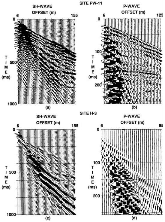
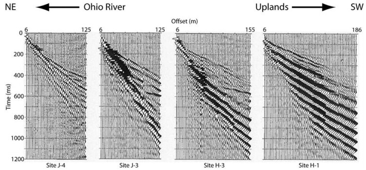
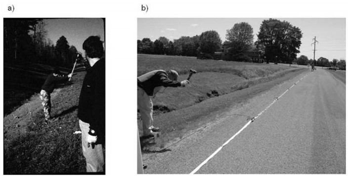
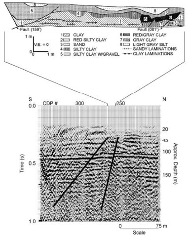
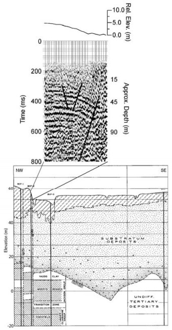
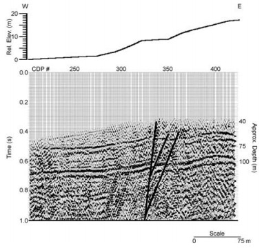
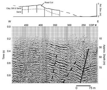
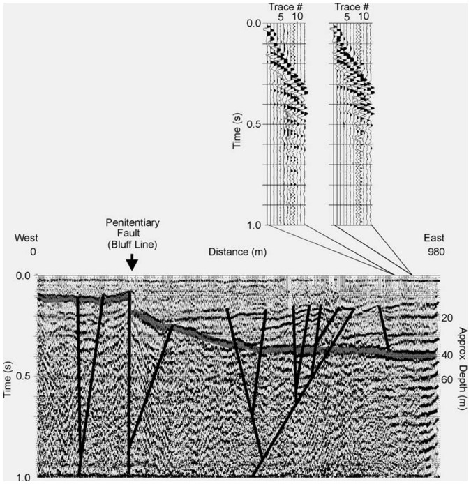
Shallow shear-wave seismic reflection imaging, using a sledgehammer and mass energy source and standard processing, has become increasingly common in mapping near-surface geologic features, especially in water-saturated, unconsolidated sediments. Tests of the method in the Mississippi Embayment region of the central United States show interpretable reflection arrivals in the depth range of < 10 m to > 100 m with the potential for increased resolution when compared with compressional-wave data. Shear-wave reflection profiles were used to help interpret the significance of neotectonic surface deformation at five sites in the Mississippi Embayment. The interpreted profiles show a range of shallow structural styles that include reverse faulting, fault propagation folding, and reactivated normal faulting, and provide crucial subsurface evidence in support of paleoseismologic trenching and shallow drilling.
The relationship between contemporary seismicity and shallow geologic structure is one of the most important topics of research related to seismic hazard evaluation in the Mississippi Embayment region of the central United States. Seismic activity in the Mississippi Embayment is dominated by earthquakes that occur in the New Madrid seismic zone, the most active seismic zone in the central and eastern United States (Fig. 1) and home to the great New Madrid earthquake sequence of 1811–1812 (Johnston and Schweig, 1996). Determining the association between seismicity and surface deformation in the Mississippi Embayment is hindered by the presence of thick, water-saturated, unconsolidated sediments. The upward continuation of basement faults into the nearsurface (Tertiary and Quaternary) sands, gravels, silts, and clays is often masked by the inability of the soft sediments to propagate large fractures, making identification and age determination of near-surface faults a difficult problem because deformation is often distributed over a complex zone of disturbance.
Although P-wave (compressional wave) reflection methods have been used for 30 years for imaging faults in the Paleozoic through Tertiary deposits of the Mississippi Embayment (e.g., Stephenson et al., 1999; Williams et al., 1995; Schweig et al., 1992; Sexton and Jones, 1986; Zoback, 1979), only in the last two decades has detailed seismic investigation of deformed Quaternary sediments, primarily using S-wave (shear wave) methods, been undertaken (e.g., Cox et al., 2006, 2001, 2000; Harris and Sorrells, 2006; Baldwin et al., 2005, 2002; Woolery et al., 1999, 1996, 1993; Harris et al., 1998). One of the principal justifications for using S-waves is the potential for increased seismic resolution (compared with conventional Pwave methods) in the water-saturated, shallow sediments of the Mississippi Embayment—an important consideration in light of the modest surface deformation in the region.
Through direct comparison with shallow P-wave reflection data, this article shows the influence of near-surface geology (sediment composition and water saturation) on seismic data quality, and the increased resolving power of S-wave seismic reflection methods in unconsolidated, water-saturated sediment sequences. Finally, five brief case histories are presented in which low-cost, hammer-impact S-wave seismic reflection profiling was directly integrated into neotectonic investigations (supporting surficial mapping, shallow drilling, and paleoseismologic trenching) of surface deformation in the Mississippi Embayment.
The structural configuration of the Mississippi Embayment is a south-plunging syncline containing a thick sequence of unconsolidated to poorly consolidated gravels, sands, silts, and clays, and weakly lithified sedimentary rocks. The sediments and sedimentary rocks filling the Paleozoic bedrock trough range in age from Late Cretaceous to Quaternary and thicken southwestward from ~100 m at Paducah, Kentucky, near the northern boundary of the Mississippi Embayment, to >1 km in the vicinity of Memphis, Tennessee.
The first suggestion for the origin of the Mississippi Embayment, by Burke and Dewey (1973), was that its formation was due to a failed rift arm. Ervin and McGinnis (1975) expanded this idea and presented the Mississippi Embayment as a Late Precambrian or Early Cambrian rift zone. During the Late Mesozoic, the southeastern United States moved across the Bermuda Hotspot, causing reactivation of the rift complex followed by subsidence and deposition of marine sands and clays from the southwest and fluvial clastics from the north (Cox and van Arsdale, 2002, 1997). Instability of the crust in the vicinity of the rift complex is believed to be responsible for earthquakes in the upper Mississippi Embayment (Herrmann and Canas, 1978). Reactivation of favorably oriented zones of weakness in response to the regional stress field has been presented as the driving mechanism for the seismicity.
The choice of the SH-wave (horizontally polarized) as the preferred shear wave phase is based on the theoretical determination that SH-waves are easier to identify because pure SH-wave energy reflects and refracts only as an SH-wave and, unlike P- and SVwaves (shear waves polarized in a vertical plane), do not experience mode conversion. The consistent character of shallow SH-wave reflections should, therefore, make their identification and interpretation less complicated.
SH-wave seismic reflection methods have been used to map shallow geologic features in unconsolidated, water-saturated sediments (Young and Hoyos, 2001; Harris et al., 2000; Goforth and Hayward, 1992; Hasbrouck, 1991; Suyama et al., 1987). In the Mississippi Embayment, SH-wave methods have been tested at numerous sites, mostly in support of earthquake hazard investigations (Cox et al., 2006, 2001, 2000; Harris and Sorrells, 2006; Baldwin et al., 2005, 2002; Woolery et al., 1999, 1996, 1993; Harris et al., 1998). Figure 2 shows representative field data (from Memphis, Tennessee and Paducah, Kentucky) exhibiting the range of depths (< 10 m to >100 m) imaged by hammer-impact, SH-wave reflection methods in the Mississippi Embayment.
Amplitude and frequency characteristics of Pwave reflection data are highly influenced by the depth of water saturation in near-surface materials. Because S-waves travel with the velocity of the sediment framework, they are not greatly affected by the degree of saturation, and often lead to more consistent, high-quality data in unconsolidated, watersaturated sediment sequences. For example, Fig. 3 shows a comparison between SH- and P-wave data collected at two sites (PW-11 and H-3) in the unconsolidated alluvial sediments of the lower Ohio River Valley near Paducah, Kentucky (see Fig. 1 for location). The SH-wave sections (Figs. 3a and 3c) are similar in that both show a direct arrival, a refracted arrival from a shallow horizon, and a reflection from the top of Mississippian-age limestone bedrock (~650 ms at site PW-11 and ~550 ms at site H-3). The quality of the P-wave data (Figs. 3b and 3d), however, varies quite dramatically. The site PW-11 section shows a strong refraction from the top of a shallow water table (calculated to be ~2 m deep) and an easily identifiable bedrock reflection (~160 ms), while the data from site H-3 exhibit severe high-frequency attenuation and provide little, if any, useable information. Based on a borehole log at site H-3, water was first encountered at a depth of 15 m and the near-surface, unsaturated material consisted of a heterogeneous deposit of silt, clay, and pebbly sand. These shallow conditions (thick, attenuative unsaturated zone) impede the collection of highquality P-wave data in that area.
In near-surface SH-wave reflection profiling, the presence of well-developed surface wave arrivals (Love waves) has commonly been viewed as an obstacle to collecting high-quality data and it has been shown that they can easily be misinterpreted (Miller et al., 2001). Pullan et al. (1990) observed strong Love wave arrivals interfering with shallow S-wave reflections in the presence of large S-wave velocity gradients in the near surface, and Eslick et al. (2008) demonstrated the influence that the thickness of a low-velocity surface layer (waveguide) has on the development of dispersive Love waves. Figure 4 presents four composite (walkaway) gathers collected in the Ohio River Valley near Paducah, Kentucky, showing the varying influence that the Love wave has on viewing the bedrock reflection (~100 m deep). The increasing development of the low-frequency Love wave from northeast to southwest (away from the Ohio River) is evident. The bedrock reflection can clearly be seen at sites J-3 and H-3 between 500 and 600 ms on the longer offset traces. At site J-4, the bedrock reflection is subtle, but can be viewed on the longer offset traces at about 450 ms. The bedrock reflection is masked by the surface wave at site H-1. The velocity of the surface layer (Quaternary loess and alluvium) remains fairly constant along the profile (175–220 m/s). The surface wave is well developed where the underlying unit, with a velocity of >450 m/s, is within 5–6 m of the surface.
An interesting observation regarding data quality and source-receiver offset for near-surface S-wave reflection data is related to the influence of the earth's surface. At incident angles greater than critical [sin-1(VS/VP)], amplitude, phase, and frequency changes, caused by interactions with the free surface, can distort the arriving waveform, while arrivals within the "shear-wave window" are generally undisturbed (Evans, 1984). High VP/VS ratios, commonly found in the shallow sediments of the Mississippi Embayment, reduce the width of the shear-wave window and can cause distortions on shallow reflection data recorded at offsets with incidence angles beyond critical. Furthermore, this narrowing of the shear-wave window often forces the offset range for unaltered shallow reflections to be coincident with the Love wave noise cone, and special attention is needed to insure that Love wave arrivals aren't stacked as shear-wave reflections (Miller et al., 2001). Figure 5 shows an example shot gather from a seismic profile in western Kentucky (Harris, 1996), on which the shear-wave window has been identified. Analysis of first arrivals (both S-wave and P-wave) suggests a shear-wave window ranging from 17º to 28º. Based on the VP/VS ratios and source-receiver offsets (3 to 36 m) used to image the top of a shallow gravel layer (approximately 35 m deep), incidence angles of 2º to 27º were calculated, suggesting that some of the longer offset reflection data were likely to have been modified by recording outside the shear-wave window.
Due to the small-scale deformation encountered in many shallow reflection surveys supporting neotectonic investigations, seismic resolution is frequently the most important consideration when choosing a survey method and making data acquisition decisions. Vertical resolution depends on wavelength (velocity divided by frequency), so for seismic energy of the same frequency, because Swaves travel with lower velocities than P-waves, Swavelengths are shorter and vertical resolution is higher. Even though S-waves are rarely observed in the same frequency range as P-waves (in the nearsurface deposits of the Mississippi Embayment they are commonly 0.5 to 0.25 those of P-waves), higher vertical resolution is most evident in water-saturated, alluvial material where the P-wave velocity is regularly 5 to 10 times higher than the S-wave velocity. Figure 6 compares the resolving capability of S-wave and P-wave reflections from sites with similar geology in northeastern Arkansas. The target reflection is from the Quaternary–Tertiary boundary (35–45 m deep), and an estimate of vertical resolution using the 1/4 wavelength criteria (Widess, 1973) suggests that resolving power is nearly two-thirds greater for the S-wave compared with the P-wave (1.3 m for the S-wave and 2.0 m for the P-wave). In the Mississippi Embayment, the upward continuation of basement (seismogenic?) faults into the soft sediments of the near surface (Tertiary and Quaternary) leads to a subdued, tectonically produced surface topography and makes identification and age determination of surface/near-surface deformation a difficult problem. The most common methods used to investigate shallow subsurface deformation in the Mississippi Embayment include detailed mapping of surficial geology, paleoseismologic trenching, and shallow coring, all supported by seismic reflection profiling.
The last section of this article contains example case histories showing the use of SH-wave seismic reflection methods in imaging near-surface deformation associated with neotectonic processes in the Mississippi Embayment. At all five sites (see Fig. 1 for locations), the active spread consisted of 12 receivers and the seismic energy was generated by horizontal impacts (oriented perpendicular to the spread) of a sledgehammer on a steel I-beam (Fig. 7). At one site, Tamms, Illinois, the seismic data were collected using a landstreamer, while at the other four sites the individual receivers were coupled to the ground using 6-cm spikes. The landstreamer, with geophones mounted on metal sleds tethered together by nylon webbing, was pulled behind a vehicle that stopped at regular intervals to collect the data. A major advantage of landstreamer acquisition is time efficiency (Pugin et al., 2004), although data quality sometimes suffers. However, the packed-gravel and asphalt road surface, with little traffic, offered excellent conditions for landstreamer acquisition at the Tamms site and, based on observations in the field, the data quality appeared equal to that of spike plant geophones. Table 1 summarizes the seismic data acquisition parameters for the five sites.
![]() |
Processing (on a laptop or desktop PC) followed a standard sequence for shallow common-mid-point (CMP) reflection data (e.g., Baker, 1999; Steeples and Miller, 1990) and included trace editing, bandpass filtering, and automatic gain control. The seismic data were stacked as 6-fold sections. Because there was significant topography on several of the profiles, special care was taken with elevation statics and velocity analysis.
Because low-fold, hammer-impact seismic reflection data commonly may have low signal-to-noise ratios, only basic processing steps were employed in order to minimize processing artifacts (and maximize interpretation confidence) produced by "overprocessing" noisy data (Steeples and Miller, 1998). Furthermore, the stacked sections were compared with the field records to confirm that interpreted reflections were visible on shot gathers (see Fig. 12 for example from Tamms, Illinois).
A 210-m SH-wave reflection profile (Fig. 8) was acquired across a zone of surface faulting near Monticello, Arkansas (see Fig. 1 for location). As mapped at the surface in a paleoseismologic trench (Cox et al., 2000), the faults displace Tertiary clay and gravel and Holocene silt. The seismic profile shows strong reflection energy to depths in excess of 150 m. The most coherent reflection is from a depth of 110 m and, based on correlation with local well data, is interpreted to represent the top of the Eocene Cockfield (sand) Formation. The reflections are disrupted by two south-dipping normal faults that correlate updip with faults mapped in the paleoseismologic trench. The style of folding and fracturing identified in the trench suggests that the faults were reactivated as a left-slip system in a Quaternary east-west compressional stress field.
A 135-m SH-wave reflection profile was shot across a section of the northeast-southwest trending Big Creek escarpment in eastern Arkansas (see Fig. 1 for location). The scarp was first recognized to be of tectonic origin based on geomorphic evidence (Fisk, 1944). Krinitzsky (1950) and Smith and Saucier (1971) produced borehole profiles that show down-to-thesoutheast normal faulting of Tertiary and Quaternary sediments to be coincident with the scarp. The interpreted seismic reflection profile across the Big Creek escarpment (Fig. 9) shows that the scarp is underlain by a high-angle fault that extends upward into Quaternary sediments (shallower that 45 m). Warping of shallow reflections indicates compression and suggests that the principal fault has been active as a reverse or transpressional fault in the contemporary, east-west compressional stress field.
A 330-m SH-wave reflection profile was collected at Porter Gap, Tennessee (see Fig. 1 for location), across the margin of the Chickasaw bluffs of the Mississippi River (Cox et al., 2001). The Porter Gap profile (Fig. 10) exhibits strong, continuous reflections at depths of 50–75 m and 90–120 m, both in the Eocene section. Both reflections are disrupted by a nearvertical fault complex coincident with the west-facing bluff margin. Separation on the fault is up-to-the-west, although structural relief along the line is higher on the east (consistent with topography). Therefore, the fault is interpreted to have been structurally inverted during Late Tertiary or Quaternary. This is similar to the deformational history suggested by the reflection profile across the Big Creek escarpment, over 200 km to the southwest.
The 445-m SH-wave reflection profile at New Madrid, Missouri (see Fig. 1 for location), was shot across a topographic scarp that has been recognized as the northwest extension of the Reelfoot scarp (van Arsdale et al., 1995), last active during the M=8, February 7, 1812 New Madrid earthquake (Kelson et al., 1996). Based on shallow coring and paleoseismologic trenching, the Reelfoot scarp has been interpreted as a fault propagation fold above the west-dipping Reel foot reverse fault. The interpreted profile (Fig. 11) across the New Madrid scarp shows a west-dipping reverse fault (located east of the scarp) that propagates upward from Tertiary (>40 m deep) to Quaternary sediments. This structural setting is almost identical to that imaged on the Reelfoot fault in west Tennessee (Sexton and Jones, 1986) where scarp topography and near-surface folding/extensional faulting (Kelson et al., 1996; van Arsdale et al., 1995) mimics folding and extensional faulting in the hanging-wall of the reverse fault. This is the first seismic image that clearly shows the continuation of the Reelfoot fault into Quaternary sediments, displaying the relationship between scarp topography and near-surface folding in the hangingwall of the Reelfoot fault.
The northeast-trending Commerce Geophysical Lineament (CGL), a series of gravity and magnetic anomalies extending from northeast Arkansas to central Indiana, is associated with Quaternary deformation northwest of the New Madrid seismic zone. In southern Illinois, a previous study imaged Quaternary sediments deformed along the Penitentiary fault (PF), a northeast-striking fault coincident with the CGL (Odum et al., 2002). The PF is coincident with a linear northeast-trending, east-facing bluff line that separates Late Quaternary Cache River Valley (CRV) deposits on the east from Paleozoic upland rocks on the west.A nearly 1-km SH-wave reflection profile, intersecting the PF and the CGL, was acquired near Tamms, Illinois (see Fig. 1 for location). The seismic profile (Fig. 12) displays coherent reflectors at both the bedrock-CRV unconformable contact and within the Quaternary deposits. Depth to bedrock was interpreted as approximately 30–50 m deep in the CRV and approximately 10 m deep west of the bluff line. Coincident with the bluff line and the PF is a complex zone of high-angle faults that may project into overlying Quaternary alluvium. In the eastern part of the section, transpressive (?) faulting is interpreted as projecting upsection across several reflectors within the Quaternary CRV sediments. These eastern faults may be associated with a previously unidentified fault zone east of the PF.
This article illustrates the effective use of shallow (10–100 m deep) hammer-impact shear-wave seismic reflection data applied to neotectonic studies in unconsolidated sediments of the Mississippi Embayment. The examples show that shallow SHwave reflection data are most useful in situations where high resolution is required and supplemental geologic information (paleoseismologic trenching/ coring and borehole data) is either already available or field work is being planned. Data acquisition is lowcost, minimum-impact (environmentally), and rapid (due to typically small study areas). Processing is relatively straightforward (desktop/laptop PC and inexpensive software) and a preliminary section can be produced in near real time to aid in selecting paleoseismologic trench locations, choosing drilling sites, and interpreting geologic features in the field.
ACKNOWLEDGMENTS: The case histories section of this article is a compilation of undergraduate geophysics research projects at Millsaps College. The student researchers included Will Beard, Seth Berman, Brant Cole, Shea Maddox, Bill Reid, Steve Sloan, Jenn Sorrells, and Erin Elliott. This work was supported, in part, by the U.S. Geological Survey, Department of the Interior. The views and conclusions contained in this document are those of the authors and should not be interpreted as necessarily representing the official policies, either expressed or implied, of the U.S. government.Baker, G. S., 1999. Processing Near-Surface Seismic-Reflection Data: A Primer. In: Young, R., ed., Society of Exploration Geophysicists, Course Notes Series No. 9, 77 |
Baldwin, J. N., Barron, A. D., Kelson, K. I., et al., 2002. Preliminary Paleoseismic and Geophysical Investigation of the North Farrenburg Lineament: Primary Tectonic Deformation Associated with the New Madrid North Fault? Seismological Research Letters, 73: 393–413 doi: 10.1785/gssrl.73.3.393 |
Baldwin, J. N., Harris, J. B., van Arsdale, R. B., et al., 2005. Constraints on the Location of the Late Quaternary Reelfoot and New Madrid North Faults in the Northern New Madrid Seismic Zone, Central United States. Seismological Research Letters, 76(6): 772–789 doi: 10.1785/gssrl.76.6.772 |
Burke, K., Dewey, J. F., 1973. Plume Generated Triple Junctions: Key Indicators in Applying Plate Tectonics to Old Rocks. Journal of Geology, 81: 406–433 doi: 10.1086/627882 |
Cox, R. T., Cherryhomes, J., Harris, J. B., et al., 2006. Paleoseismology of the Southeastern Reelfoot Rift in Western Tennessee, U.S.A., and Implications for Intraplate Fault Zone Evolution. Tectonics, 25: TC3019, 17 http://umdrive.memphis.edu/randycox/public/tectonics%20structure%20papers/CEUS%20neotectonics%20papers/Cox%20et%20al%20proofs%202006.pdf |
Cox, R. T., van Arsdale, R. B., 1997. Hotspot Origin of the Mississippi Embayment and Its Possible Impact on Contemporary Seismicity. Engineering Geology, 46: 201–216 doi: 10.1016/S0013-7952(97)00003-3 |
Cox, R. T., van Arsdale, R. B., 2002. The Mississippi Embayment, North America: A First Order Continental Structure Generated by the Cretaceous Superplume Mantle Event. Journal of Geodynamics, 34(2): 163–176 doi: 10.1016/S0264-3707(02)00019-4 |
Cox, R. T., van Arsdale, R. B., Harris, J. B., et al., 2000. Quaternary Faulting in the Southern Mississippi Embayment and Implications for Tectonics and Seismicity in an Intraplate Setting. Geological Society of America Bulletin, 112(11): 1724–1735 doi: 10.1130/0016-7606(2000)112<1724:QFITSM>2.0.CO;2 |
Cox, R. T., van Arsdale, R. B., Harris, J. B., et al., 2001. Neotectonics of the Southeastern Reelfoot Rift Zone Margin, Central United States, and Implications for Regional Strain Accommodation. Geology, 29(5): 419–422 doi: 10.1130/0091-7613(2001)029<0419:NOTSRR>2.0.CO;2 |
Ervin, C. P., McGinnis, L. D., 1975. Reelfoot Rift: Reactivated Precursor to the Mississippi Embayment. Bulletin, Geological Society of America, 86(9): 1287–1295 doi: 10.1130/0016-7606(1975)86<1287:RRRPTT>2.0.CO;2 |
Eslick, R., Tsoflias, G., Steeples, D., 2008. Field Investigations of Love Waves in Near-Surface Seismology. Geophysics, 73(3): G1–G6 doi: 10.1190/1.2901215 |
Evans, R., 1984. Effects of the Free Surface on Shear Wavetrains. Geophysical Journal, Royal Astronomical Society, 76: 165–172 doi: 10.1111/j.1365-246X.1984.tb05032.x |
Fisk, H. N., 1944. Geological Investigation of the Alluvial Valley of the Lower Mississippi River. Mississippi River Commision, Vicksburg, Mississippi. 78 |
Goforth, T., Hayward, C., 1992. Seismic Reflection Investigations of a Bedrock Surface Buried under Alluvium. Geophysics, 57: 1217–1227 doi: 10.1190/1.1443337 |
Harris, J. B., 1996. Shear-Wave Splitting in Quaternary Sediments: Neotectonic Implications in the Central New Madrid Seismic Zone. Geophysics, 61: 1871–1882 doi: 10.1190/1.1444102 |
Harris, J. B., Berman, S. A., Beard, W. C., et al., 1998. Shallow Seismic Reflection Investigations of Neotectonic Activity in the Lower Mississippi Valley. 68th Annual International Meeting of the Society of Exploration Geophysicists, Expanded Abstracts. 848–851 |
Harris, J. B., Miller, R. D., Xia, J., et al., 2000. Near-Surface Shear Wave Reflection Surveys in the Fraser River Delta, B.C., Canada. 70th Annual International Meeting of the Society of Exploration Geophysicists, Expanded Abstracts. 1327–1330 |
Harris, J. B., Sorrells, J. L., 2006. Shear-Wave Seismic Reflection Images of the Big Creek Fault Zone near Helena, Arkansas. 76th Annual International Meeting of the Society of Exploration Geophysicists, Expanded Abstracts. 1500–1505 |
Hasbrouck, W. P., 1991. Four Shallow-Depth, Shear-Wave Feasibility Studies. Geophysics, 56: 1875–1885 doi: 10.1190/1.1442999 |
Herrmann, R. B., Canas, J. A., 1978. Focal Mechanism Studies in the New Madrid Seismic Zone. Bulletin, Seismological Society of America, 68(4): 1095–1102 doi: 10.1785/BSSA0680041095 |
Johnston, A. C., Schweig, E. S., 1996. The Enigma of the New Madrid Earthquakes of 1811–1812. Annual Review of Earth and Planetary Sciences, 24: 339–384 doi: 10.1146/annurev.earth.24.1.339 |
Kelson, K. I., Simpson, G. D., van Arsdale, R. B., et al., 1996. Multiple Late Holocene Earthquakes along the Reelfoot Fault, Central New Madrid Seismic Zone. Journal of Geophysical Research, 101(B3): 6151–6170 doi: 10.1029/95JB01815 |
Krinitzsky, E. L., 1950. Geological Investigation of Faulting in the Lower Mississippi Valley. U. S. Army Corps of Engineers Waterways Experiment Station Technical Memorandum 3–311: 50 |
Miller, R. D., Xia, J., Park, C. B., 2001. Love Waves: A Menace to Shallow Shear Wave Reflection Surveying. 71st Annual International Meeting, Society of Exploration Geophysicists, Expanded Abstracts. 1377–1380 |
Odum, J. K., Stephenson, W. J., Williams, R. A., et al., 2002. Near-Surface Faulting and Deformation Overlying the Commerce Geophysical Lineament in Southern Illinois. Seismological Research Letters, 73(5): 687–697 doi: 10.1785/gssrl.73.5.687 |
Pugin, A. J. M., Larson, T. H., Sargent, S. L., et al., 2004. Near-Surface Mapping Using SH-Wave and P-Wave Seismic Landstreamer Data Acquisition in Illinois, U.S. . The Leading Edge, 23(7): 677–682 doi: 10.1190/1.1776740 |
Pullan, S. E., Hunter, J. A., Neave, K. G., 1990. Shallow Shear-Wave Reflection Tests. 60th Annual International Meeting, Society of Exploration Geophysicists, Expanded Abstracts. 380–382 |
Schweig, E. S. III, Shen, F., Kanter, L. R., et al., 1992. Shallow Seismic Reflection Survey of the Bootheel Lineament Area, Southeastern Missouri. Seismological Research Letters, 63: 285–295 doi: 10.1785/gssrl.63.3.285 |
Sexton, J. L., Jones, P. B., 1986. Evidence for Recurrent Faulting in the New Madrid Seismic Zone from Mini-Sosie High-Resolution Reflection Data. Geophysics, 51(3): 1760–1788 http://www.onacademic.com/detail/journal_1000039785190710_2bcb.html |
Smith, F. L., Saucier, R. T., 1971. Geological Investigation of the Western Lowlands Area, Lower Mississippi Valley. U.S. Army Corps of Engineers Waterways Experiment Station Technical Report S-71-5, 44 Plates |
Steeples, D. W., Miller, R. D., 1998. Avoiding Pitfalls in Shallow Seismic Reflection Surveys. Geophysics, 63(4): 1213–1224 doi: 10.1190/1.1444422 |
Steeples, D. W., Miller, R. D., 1990. Seismic-Reflection Methods Applied to Engineering, Environmental, and Groundwater Problems. In: Ward, S. H., ed., Society of Exploration Geophysicists, Investigations in Geophysics. Review and Tutorial, 1(5): 1–30 |
Stephenson, W. J., Odum, J. K., Williams, R. A., et al., 1999. Deformation and Quaternary Faulting in Southeast Missouri across the Commerce Geophysical Lineament. Bulletin, Seismological Society of America, 89: 140–155 http://www.researchgate.net/profile/W_J_Stephenson/publication/265223103_Deformation_and_Quaternary_Faulting_in_Southeast_Missouri_across_the_Commerce_Geophysical_Lineament/links/5617b8a808ae353151bb0dd8.pdf |
Suyama, K., Imai, T., Ohtomo, H., et al., 1987. Delineation of Structures in Alluvium and Diluvium Using SH-Wave Reflection and VSP Methods. In: Danbom, S. H., Domenico, S. N., eds., Shear-Wave Exploration. Society of Exploration Geophysicists. Geophysical Developments, 1: 165–179 |
van Arsdale, R. B., Kelson, K. I., Lumsden, C. H., 1995. Northern Extension of the Tennessee Reelfoot Scarp into Kentucky and Missouri. Seismological Research Letters, 66(5): 57–62 doi: 10.1785/gssrl.66.5.57 |
Widess, M. B., 1973. How Thin is a Thin Bed? Geophysics, 38: 1176–1180 doi: 10.1190/1.1440403 |
Williams, R. A., Luzetti, E. A., Carver, D. L., 1995. High-Resolution Seismic Imaging of Quaternary Faulting on the Crittenden County Fault Zone, New Madrid Seismic Zone, Northeastern Arkansas. Seismological Research Letters, 66: 42–57 |
Woolery, E. W., Street, R. L., Wang, Z., et al., 1999. Neotectonic Structure in the Central New Madrid Seismic Zone: Evidence from Multimode Seismic-Reflection Data. Seismological Research Letters, 70: 554–576 doi: 10.1785/gssrl.70.5.554 |
Woolery, E. W., Street, R., Wang, Z., et al., 1993. Near-Surface Deformation in the New Madrid Seismic Zone as Imaged by High-Resolution SH-Wave Seismic Methods. Geophysical Research Letters, 20(15): 1615–1618 doi: 10.1029/93GL01658 |
Woolery, E. W., Wang, Z., Street, R. L., et al., 1996. A P- and SH-Wave Seismic Reflection Investigation of the Kentucky Bend Scarp in the New Madrid Seismic Zone. Seismological Research Letters, 67: 67–74 http://citeseerx.ist.psu.edu/viewdoc/download;jsessionid=94B98FE58DA45A3FF4573BC7A0CAD0A6?doi=10.1.1.1022.9272&rep=rep1&type=pdf |
Young, R. A., Hoyos, J., 2001. Near-Surface, SH-Wave Surveys in Unconsolidated, Alluvial Sediments. The Leading Edge, 20(9): 936–948 doi: 10.1190/1.1487314 |
Zoback, M. D., 1979. Recurrent Faulting in the Vicinity of Reelfoot Lake, Northwestern Tennessee. Bulletin, Geological Society of America, 90: 1019–1024 doi: 10.1130/0016-7606(1979)90<1019:RFITVO>2.0.CO;2 |