
Citation: | Yuan Wan, Jiandong Xu, Bo Pan, Jingwei Zhang, Hongmei Yu, Bo Zhao, Feixiang Wei. Volcanic Hazard Mapping for Changbaishan-Tianchi Region, China. Journal of Earth Science, 2024, 35(6): 2030-2044. doi: 10.1007/s12583-021-1569-x |
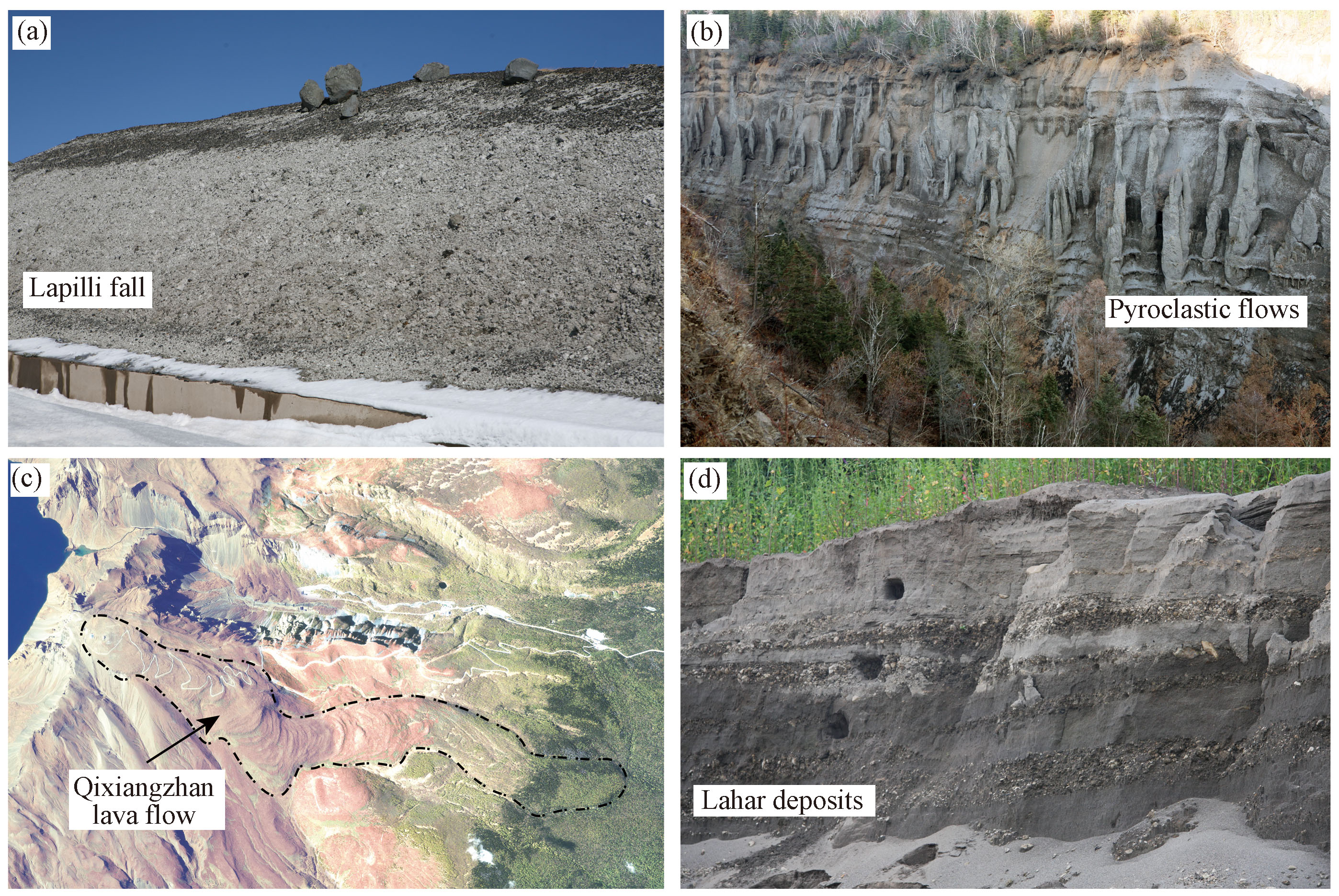
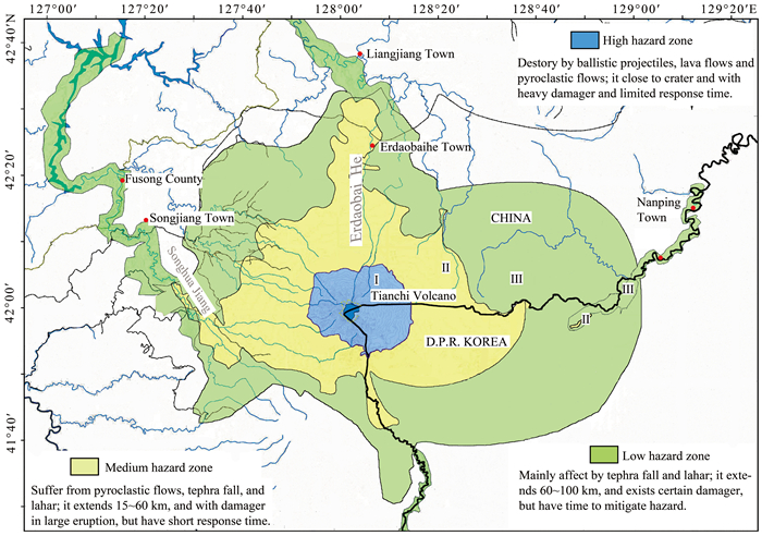
Volcanic hazard zoning is an effective way to reduce and mitigate volcanic risks. Due to its frequent magmatic unrest and potential for catastrophic eruption, the Changbaishan-Tianchi Volcano is currently the focus of attention for volcanic disaster prevention in China. This study uses past eruption data obtained from geological surveys and geochronological studies, to construct simulations of tephra fall, pyroclastic flows, lava flows, and lahars. Several widely accepted numerical models were adopted to simulate each hazard at different eruption scales. Hazard zoning was then conducted, producing a comprehensive hazards map of the Changbaishan-Tianchi Volcano. The map identifies areas of high, medium, and low hazard, mostly at 0–15, 15–60, 60–100 km from the edifice. This work serves as the scientific basis for the authorities and general public in the areas around the Changbaishan-Tianchi Volcano in planning for future response, as well as provides a reference for hazard zoning in other areas potentially affected by volcanic hazards.
Volcanoes are a major source of natural hazards for communities worldwide, ranked 6th by the committee of the International Decade for Natural Disaster Reduction (Brown et al., 2015; Calder et al., 2015; Doocy et al., 2013; Xu, 2006). There have been 1 422 volcanoes erupted in the Holocene (https://volcano.si.edu). The 1815 eruption of the Tambora Volcano in Indonesia was directly associated with the death of more than 88 000 people (Auker et al., 2013; Stothers, 1984). In 1985, the town of Armero, Colombia was buried by lahars with more than 21 000 fatalities attributed to relatively small explosive eruptions at the summit of Nevado del Ruiz Volcano, exacerbated by interaction with a glacier (Voight, 1990). The most recent volcanic eruption of global concern was the 2011 eruption of Eyjafjallajökull, Iceland, which disrupted air travel over the Atlantic Ocean and Europe, causing significant economic losses (Ragona et al., 2011; Gudmundsson et al., 2010a, b; Xu et al., 2010). A large number of people (estimated at~10%, Loughlin et al., 2015) continue to live within areas of significant volcanic hazards, in part due to their fertile soil, and as such volcanic hazards are one of the major environmental dangers worldwide (Brown et al., 2015; Aspinall et al., 2011).
Volcanic hazard zoning is an effective method in the mitigation of volcanic hazards (e.g., Cui et al., 2022; Lindsay and Robertson, 2018; Favalli et al., 2009; Xu, 2006; Magill and Blong, 2005; Tilling, 2005; Scarpa and Tilling, 1996). Based on past disaster events from a particular volcano, the method utilizes numerical simulations or empirical methods to predict areas that may be affected by future eruptions, providing a reference for local authorities in land management and emergency response. Typically, volcanic hazard zoning mainly considers the type and extent of volcanic hazards; different types of hazards are associated with characteristic risks, and the impacted areas and severity of damages depend on the eruption scenario. These factors are usually considered comprehensively when producing a volcanic hazard zoning map, wherein the affected areas and the type/extent of hazards are depicted.
Hazard zoning maps have been categorized into five main families by Calder et al. (2015), depending on the type of information incorporated in the map and how it is conveyed, including geology-based maps, integrated qualitative maps, administrative maps, modeling-based maps and probabilistic maps. In addition, hazard-specific maps have been used, such as lahar hazard maps for Mombacho, Nicaragua (Vallance et al., 2001a, b) and Mount Rainier, USA (Hoblitt et al., 1995). Others often integrate multiple potential hazards to provide overall hazard assessment and establish hazard zones accordingly. The second type of zoning map has been created for instance for Mount St. Helens, USA (Edward and Thomas, 1995), and can indicate not only the severity and range of volcanic hazards, but also the types thereof. Volcanic hazard zone mapping is relatively new in China. Liu and Xiang (1997) systematically studied the pyroclastic deposits formed from the Cenozoic eruption of the Changbaishan-Tianchi Volcano, plotting its distribution, but did not conduct further hazard zoning. Yang et al. (2006, 2003) used past geological surveys to demarcate hazard ranges of Changbaishan-Tianchi by phenomena type and created an approximate zoning map for volcanic hazards. Yu et al. (2013) have constructed a probability map of tephra fall hazard at Changbaishan-Tianchi Volcano using a dispersion model. However, those studies have been conducted on single hazard map, and no comprehensible volcanic zoning maps have been published for volcanoes in China.
Changbaishan-Tianchi is the largest active volcano in China. A catastrophic (VEI~7) eruption in 946–947 AD affected much of the Northern Hemisphere (Pan et al., 2020; Sun et al., 2014; Machida, 1999). The magma reservoir of the volcano is still active, and a swarm episode of several minor earthquakes and surface deformation recently occurred (2002–2006), suggesting that the risk associated with a future eruption must be examined and prepared (Xu et al., 2012). This risk has caused great concern to the local and national government (Pan et al., 2021). Here, based on previous research on hazards of the Changbaishan-Tianchi, we present the results of numerically simulation of four types of hazards, tephra fall, pyroclastic flows, lava flows, and lahar, using a diffusion model (Suzuki, 1983), FLOW3D (Kover, 1995), FLOWGO (Harris and Rowland, 2001), and LAHARZ (Iverson, 1997), respectively, and generating zoning maps for each hazard. These were then combined to construct a comprehensive hazard zoning map for Changbaishan-Tianchi. This is the first volcanic hazard zoning map for the Changbaishan-Tianchi Volcano and will provide a reference for local authorities, support disaster response planning, and serve as an example for other active volcanic areas.
Changbaishan-Tianchi Volcano, located on the China-North Korea border in eastern Jilin Province, China (Figure 1), is the youngest of three adjacent caldera volcanos in the region (Pan et al., 2017b; Wei et al., 2013). Earliest eruptive activity began around 5 Ma, and it has experienced a shield-building stage (5–2 Ma), cone-building stage (2–0.05 Ma), and explosive stage (0.05 Ma to recent) (Wei et al., 2013; Liu et al., 1998; Jin and Zhang, 1994). The shield-building stage was dominated by the effusive eruption of basaltic magma, which formed a wide and flat lava plateau. In the cone-building stage, the magma gradually evolved towards trachytic magma, with autochthonous deposits gradually forming a towering cone (Wei et al., 2013). Towards the end of this stage, the magma evolved to comenditic magma, and several large-scale explosive eruptions occurred, destroying the original towering cone and forming the present-day caldera, where the accumulation of water formed Tianchi Lake (Chen et al., 2021; Pan et al., 2020, 2017b). Tianchi Lake is currently 2 194 m above sea level, with a maximum depth of 373 m and storage capacity of 2 billion m3, which makes it a potentially dangerous alpine lake (Yang et al., 2018).
The Changbaishan-Tianchi Volcano is currently in an explosive stage, which began about 50 000 years ago with the Tianwenfeng eruption, followed by the Qixiangzhan and Millennium eruptions (Pan et al., 2020, 2017b; Sun et al., 2017; Yang and Bo, 2007). Few studies have been conducted on the Tianwenfeng eruption, which is mainly known to have formed the present-day Tianchi caldera. Although the deposits from this eruption are poorly exposed, this eruption is generally regarded as a large-scale explosive eruption similar to the Millennium eruption (Figure 1; Pan et al., 2020). The 8.1 ka Qixiangzhan eruption was a predominately effusive eruption, with lava flows covering the northern slope of the cone, which is considered characteristic of the lava flow hazards from the Changbaishan-Tianchi Volcano (Pan et al., 2020; Sun et al., 2018; Nie, 2006; Li et al., 1999). The most well-known eruption is the large-scale 946–947 AD Millennium eruption (Pan et al., 2020; Oppenheimer et al., 2017; Sun et al., 2014; Machida, 1999), which was accompanied by a variety of hazardous phenomena: volcanic ash from eruption column entered the stratosphere and spread to most of the Northern Hemisphere. Pyroclastic flows reached 50 km from the crater, leaving large quantities of carbonized wood in their deposits (McLean et al., 2018; Sun et al., 2014; Mastrolorenzo et al., 2008; Casadevall, 1994; Wei, 1991).
Some researchers have suggested that some historical eruptions may have occurred in 1018, 1124, 1265, 1373, 1401, 1573, 1668, 1702, and 1903 AD (Wei et al., 2005; Liu et al., 1998; Liu and Xiang, 1997), although no erupted magmatic materials of these eruptions have been found, suggesting that these were likely non-magmatic episodes.
Geophysical exploration of the Changbaishan-Tianchi Volcano has revealed the presence of a low-velocity anomaly in the shallow crust, which was interpreted as a crustal magma chamber. Continuous replenishment and mixing of the chamber with deeper materials are also known (Sun et al., 2021; Fan et al., 2020; Wu et al., 2007; Duan et al., 2003). Therefore, the probability of another eruption is significant in the near future. The developing tourism industry and increasing local population that has established in this area present heightened risk to life if mitigation measures are not adopted.
The volcanic hazards of the Changbaishan-Tianchi area are categorized into tephra fall, pyroclastic flows, lava flows, and lahars. Here, each phenomenon will be addressed in relation to the development of the volcano (see Figure 2).
Tephra fall is one of the main volcanic hazards of the Changbaishan-Tianchi Volcano. The magma of Changbaishan-Tianchi is presently comenditic-trachytic and volatile-rich, therefore prone to explosive eruptions. Of the three confirmed eruptions since the Late Pleistocene, two were cataclysmic explosive eruptions, whereas the third, the Qixiangzhan eruption, also produced large quantities of tephra. The eruption columns of these eruptions reached the stratosphere. Most fallout was deposited SE of the Tianchi caldera (Pan et al., 2020; McLean et al., 2018; Machida et al., 1990; Machida and Arai, 1983). Fall deposits of the Millennium eruption accumulated to several meters thick in the Tianchi caldera. The thickest layer, which is more than 20 m thick, is located on the western slope (Pan et al., 2020). Fall deposits more than 1 m thick are mostly found within 30 km of the crater. Finer tephra from the Millennium eruption spread through most of the Northern Hemisphere, as revealed by samples detected in recent years in the Sea of Japan, Kushu Lake (northern Japan), Suigetsu Lake (central-southern Japan), and even Greenland (McLean et al., 2018; Chen et al., 2016; Sun et al., 2014).
The eruption column of the Millennium eruption of Changbaishan-Tianchi reached 25 km (Wei et al., 2005), and unsurprisingly gave rise to pyroclastic flows. Field surveys have shown that these flows reached as far as 50 km from the edifice (Zhao et al., 2020). Since the area around the volcano was uninhabited at that time, there is no historical record of the event, and its range is only known from its deposits. Flow deposits hundreds of meters thick accumulated in the proximal gullies, wherein welding and subsequent cooling formed columnar joints (Pan et al., 2017b). Large amounts of carbonized wood are exposed at the front edge of the pyroclastic flow (Xu et al., 2012).
Lava flows from Changbaishan-Tianchi occurred mainly during its shield-building stage (5–2 Ma). Effusive eruptions have been rare since the Late Pleistocene, as the magma evolved towards a trachytic-comenditic composition. Only one recent comenditic lava flow, the Qixiangzhan flow unit on the north slope of Changbaishan-Tianchi, has been identified. The 8 ka lava flow meandered from the summit to the Betula ermanii forest (1 600 m above sea level) (Pan et al., 2020; Sun et al., 2018). The lava flow is 5.4 km long and 300–800 m wide, showing characteristics of multi-stage eruption (Pan et al., 2020). It consisted of comenditic magma that was relatively viscous and located very close to the crater. For this reason, lava is only of concern for the tourist facilities on the slope.
A massive lahar also resulted from the Millennium eruption of Changbaishan-Tianchi (Liu et al., 1998; Liu and Xiang, 1997). Large amounts of loose pyroclastic material were mixed with water from the Tianchi caldera lake and snowmelt, flowing along various gullies and river channels. Field geological surveys revealed that Erdaobaihe, a town in the Changbaishan area that saw recent development, sits atop the Millennium eruption lahar deposit, which reached tens of meters thick when excavated. Lahars reached as far as Jilin City 300 km away, highlighting the relevance of lahar hazards. To date, the Tianchi caldera lake has a water storage capacity of 2 km3 (Yang et al., 2018), which could lead to lahar formation in the event of an eruption. Furthermore, several towns/cities with populations of 100 000 s have been established along the Erdaobaihe River, along which several large reservoirs have been constructed. In the case of a volcanic eruption, lahars pose a critical risk to local populations and regional infrastructure.
Volcanologists worldwide have conducted hazard zoning for a number of active volcanoes. Given the current state of the Changbaishan-Tianchi Volcano, its potential hazards, and the current research capability, this study adopted numerical methods to simulate each type of hazard separately, which were then compiled to generate an overall hazard zoning map for the Tianchi Volcano. Internationally well-established methods were chosen, whose basic theories are described here.
Tephra fall is the focus of concern for the Tianchi Volcano due to its evolved, volatile-rich magma, which is prone to generate explosive eruptions. Relatively large rocks are dangerous mainly as ballistic projectiles, while finer particles can reach higher altitudes and spread over a larger area. Therefore, the simulation of tephra fall hazard is divided between a ballistic model and a diffusion-based model (see Figure 3). Each pyroclastic particle is ejected with an initial velocity and angle. The particle would then travel in a parabolic trajectory through the air subject to drag and gravity before eventually settling on the ground. This process can be described mathematically via integration with Newton's second law.
The reach of the ballistic projectiles can be estimated by Eq. (1) from Mastin (2001)
x(t)=1μln(μvxcosθt+1) |
(1) |
where µ is a constant which can be calculated by Eq. (2); t is the flight time which can calculate using Eq. (3)
μ=ρaACd2m |
(2) |
t=1√μg[cos−1√1+μgv2sin2θ+tan−1(√μgvsinθ)] |
(3) |
where θ is the ejection angle, ρ0 is the air density, A is the cross section area of the block, Cd is the drag coefficient of the block, m is the mass of the particle, v is the initial velocity, and vx is the horizontal velocity.
vx=v⋅cosθ |
(4) |
Using these equations, we can then calculate the range of different projectile sizes ejected at different velocities. Areas affected by such projectiles are assigned the highest hazard level.
The diffusion and settling of volcanic ash and pumice are based on a two-dimensional diffusion model of pyroclastic materials by Suzuki (1983), which considers the diffusion of particles in the eruption column, horizontal advection due to atmospheric circulation, horizontal diffusion due to atmospheric turbulence, and gravitational settling of particles. The model calculates the total mass of pyroclastic materials settling at a point (x, y) using the following formula
X(x,y)=d=∞∫d=0z=H∫z=05P(z)8πCt5╱2exp[−5{(x−ut)2+y2}8Ct5╱2]dqdz |
(5) |
where C is a constant; x and y are the coordinates of the surface point (0, 0 is the vent position); u is the wind speed; t is the settling time; z is the height of the eruption column, and P(z) is a concentration distribution along the eruptive column. In this model, hazards from tephra fall can be simulated for a set of given parameters such as eruption magnitude and regional climatic factors, and the results can be zoned according to hazard levels and specific scenarios.
Pyroclastic flow simulations were conducted using Flow3D software (see Figure 4), developed by Sheridan and Macias (1992), Kover (1995), Sheridan et al. (2004). Its fundamental principle is a sliding block model based on Coulomb drag. The pyroclastic flow is modeled using the sliding block and the change in its speed is calculated by the construction of an irregular triangular grid or a 3D digital elevation model using the triangular irregular network method. This mathematical model includes two equations.
Conservation of energy is calculated using Eq. (6)
mgh+0.5mv02=F1l1+......+Fnln+0.5mvn2 |
(6) |
And drag is calculated using Eq. (7)
τ=a0+a1v+a2v2 |
(7) |
where m is the mass of debris; g is the gravitational acceleration; v0 is the initial speed; h is the height between the crater edge and the stop surface; F is the drag; l is the length; n is the different elevation segment; v is the flow speed; a0, a1, and a2 represent the coefficients of basic friction, internal friction, and turbulent drag. The model can be used to calculate the distances pyroclastic flows can reach along different paths under different eruption scales. The results can be used to estimate pyroclastic flow hazard zones.
The study of multiple lava flow eruptions in volcanoes such as Mauna Loa and Kilauea in Hawaii, USA, and Mount Etna, Italy has shown that the lava flow processes are similar to those of rivers (Zhang et al., 2022; Lipman and Banks, 1987; Lockwood et al., 1987). Under the influence of relatively high embankments of two sides, lava flows forward and downward along low-lying terrain as channelled flow. Heat loss during the flow process affects the speed, temperature, viscosity, and crystallization of lava flows (Felpeto et al., 2001; Wright et al., 1992). Harris and Rowland (2001) developed the FLOWGO model (see Figure 5), which assumes that lava flows in a set channel according to the mass conservation principle. The speed and temperature of a lava flow are main parameters controlling its forward movement. When the speed reaches 0 or the temperature is lower than the solidification temperature, the lava flow will stop and solidify; otherwise, it will continue to flow. The main governing equations, speed of lava flow can be calculated using Eq. (8)
V=d2ρlavagsinθ3η[1−3YScore2YSbase+12(YScoreYSbase)3] |
(8) |
Temperature changing of inner lava flow caused by heat loss can be calculated using Eq. (9)
δT/δx=ΔH/[Erρlava Lcryst δφmicro /δx] |
(9) |
where d is the lava thickness, ρlava is the density of the lava, g is the gravitational acceleration, θ is the angle of the slope of the terrain, η is viscosity, YScore/YSbase is the ratio of the yield strength between the core and base of the lava flow, Er is the overflow rate, Lcryst is the latent heat of crystallization, and δφmicro/δx is the amount of change in crystallization (Pan et al., 2017a; Harris and Rowland, 2001). Using these equations, lava zoning was conducted by calculating the estimated impacted area along various potential paths under different eruption scenarios.
A semi-empirical mathematical model, LAHARZ, established by Iverson (1997) based on the characteristics of 27 lahar flows from 9 volcanic eruptions was used in this study. The total volume of the lahar is set to be constant. The lahar is considered to stop flowing when its total volume is equal to the eruption volume, where A is the furthest distance affected by the lahar (see Figure 6). The governing fuctions are given in Eqs. (10)
A=0.05V2/3;B=200V2/3(10) |
(10) |
where the accumulation is divided into the cross-sectional areas A (vertical) and B (horizontal), the product of A and B is the cross-section filling volume, and the integral of the cross-section filling volume can be used to obtain the total lahar volume, V. These equations are used in LAHARZ (Iverson et al., 1998) to estimate the distribution of lahars under different scenarios.
Various eruption scenarios were simulated based on current terrain data of the Changbaishan-Tianchi Volcano and surrounding areas. Details of the parameters used in the simulations and the zoning process of each hazard are described here.
Calculations of projectile hazards was made using the ballistic model by Mastin (2001), with the initial projectile speed set as 300 m/s and ejection angle is 45º (Liu et al., 1998). The furthest distance reached by projectiles was calculated to be 7.2 km. The 7.2 km zone around the caldera is therefore designated extremely hazardous for ballistic impacts.
The selection of the simulation parameters for the diffusion model was based on the following: (1) a field survey of the distribution, particle size, particle density, and shape parameters of fall deposits from the Millennium eruption and two eruptions during Tianwenfeng episode, (2) data on wind directions and wind speed variations at different heights, obtained from the meteorological observatories in the Changbaishan region in the period 1980 to 2009. The parameters based on these data are shown in Table 1. Further, the height of eruption column, set at 10, 20, and 30 km, was used to set the scale of an eruption (Yu et al., 2013). The simulation results are shown in Figure 7 and show that as the height of the eruptive column increases, the affected area expands. When the height of the eruption column is 10 km, the 1 cm isopach reaches 200 km maximum from the edifice. When the height of the eruption column is 30 km, the 1 cm isopach reaches 450 km maximum.
Parameters | Parameters of millennium eruption | Parameters of simulations | ||
Column height (km) | 35 | 10 | 20 | 30 |
Eruption volume (km3) | 120 | 50 | 100 | 120 |
Eruption velocity (m/s) | 300 | 100 | 200 | 300 |
Eruption temperature (℃) | 780 | 780 | 780 | 780 |
Intermediate particle diameter (cm) | 0.13 | 0.13 | 0.13 | 0.13 |
Minimum particle diameter (cm) | 0.006 | 0.006 | 0.006 | 0.006 |
Maximum particle diameter (cm) | 3 | 3 | 3 | 3 |
Particle variance (σd) | 1.12 | 1.12 | 1.12 | 1.12 |
Ash density (g/cm3) | 1 | 1 | 1 | 1 |
Shape parameter | 0.5 | 0.5 | 0.5 | 0.5 |
β | 0.01 | 0.5 | 0.1 | 0.01 |
The results of the numerical simulations for ballistic projectiles and tephra fall deposition were combined to construct four fall hazard zones (Figure 7d). Zone Ⅰ, a 7.2 km diameter area projected around the crater, is the extremely dangerous region, which is the range of projectiles from the edifice. Zone Ⅱ is the area affected by a 10 km eruption column. Lower-magnitude eruptions may be more likely in an active episode of the volcano, while thicker fall deposits of volcanic ash would cause serious damages to crops, buildings, and population. Zone Ⅲ is the area affected by a 20 km eruption column, which is likely less frequent during an active episode. Zone Ⅳ is the area affected by an eruption column 30 km eruption high, which is only at risk during the largest-scale eruptions. Regions further away still face some degree of tephra fall hazards, but are not classified here as the impacts are relatively minor.
Pyroclastic flows were simulated using Flow3D. The physical parameters set in the simulation were derived from pyroclastic flows that occurred during the Millennium eruption. The density was set to 790 kg/m2 and the volume of a single particle is set to 0.001 26 m3 or 0.1 m. In addition, as pyroclastic flows are known to be strongly controlled by terrain, 12 valleys were selected as potential pathways for the flows in the simulation. The terrain elevation and slope of these valleys were measured based on digital elevation model (DEM) data of the Changbaishan region with 30 m resolution. The height of the eruption column used to reflect the eruption scale was set to 10, 20, and 30 km. It was assumed that the eruption column would collapse directly above the crater of the Tianchi caldera and flow only along the 12 set valleys. The results of the simulation show that the length of the pyroclastic flows formed by the 10, 20, and 30 km eruption columns would be 10.1–13.7, 31.8–35.4, and 50.3–57.8 km, respectively. The simulated flows reached the farthest distance along the Erdaobaihe valley under all three eruption scales.
The threatened areas of the pyroclastic flows were divided into three zones, marked by the maximum extent of each eruption scale (Figure 8). Zone Ⅰ is approximately 0–13 km around the crater. It is the high-hazard region for pyroclastic flow even for small scale eruptions, and severe hazards for the large-scale eruptions; Zone Ⅱ is approximately 13–35 km around the crater; this is the area at risk from medium-scale eruptions; Zone Ⅲ is approximately 35–58 km around the crater, beyond the Changbaishan-Tianchi Volcano and reaches the flat surrounding areas, only at risk during large-scale eruptions. Areas outside these zones are relatively safe, but areas close to the outer limits of Zone Ⅲ may be affected by heat waves at the leading edge of the pyroclastic flows.
Lava flows were simulated using FLOWGO. Lava parameters are based on the Qixiangzhan flow unit, including a density of 2 380 kg/m3 and an over flow temperature of 1 328 K. Environmental parameters were selected based on historical data from the regional meteorological observatory. The setting of terrain parameters was similar to that used in the pyroclastic flow simulation, with a total of 15 lava flow paths selected and their elevation and slope mapped. In the simulation, the boundary of the caldera was set as the starting point of the lava overflow. The different scales of the eruption were reflected by four overflow rates: 100, 200, 350, and 500 m3/s (Pan et al., 2017a; Harris and Rowland, 2001). The distances of the lava flows under different scales of eruption and are shown in Table 2 and Figure 9.
Effusive ratio (m3/s) | No. 15 | No. 14 | No. 13 | No. 12 | No. 11 | No. 10 | No. 9 | No. 8 |
100 | 2 951 | 3 620 | 3 791 | 2 711 | 2 664 | 3 267 | 3 220 | 3 320 |
200 | 6 212 | 6 498 | 5 866 | 5 807 | 5 447 | 4 648 | 4 772 | 6 208 |
350 | 9 956 | 12 951 | 12 121 | 12 388 | 10 541 | 9 751 | 6 127 | 7 965 |
500 | 16 282 | 16 512 | 16 827 | 17 190 | 15 741 | 12 271 | 9 752 | 10 448 |
Effusive ratio (m3/s) | No. 8 | No. 7 | No. 6 | No. 5 | No. 4 | No. 3 | No. 2 | No. 1 |
100 | 3 320 | 2 721 | 2 045 | 2 369 | 3 201 | 3 351 | 3 611 | 2 191 |
200 | 6 208 | 5 678 | 3 595 | 5 411 | 5 422 | 6 578 | 6 231 | 4 201 |
350 | 7 965 | 7 856 | 9 606 | 9 760 | 9 327 | 11 101 | 10 548 | 8 475 |
500 | 10 448 | 12 522 | 16 892 | 14 584 | 14 689 | 15 618 | 15 090 | 13 347 |
Lava flow hazards were divided into four levels. All simulated lava flows are relatively short compared with other areas such as Haiwaii, due to the high viscosity of the magma from Changbaishan-Tianchi (Figure 9). Zone Ⅰ, the high-hazard region, is distributed mainly within 2–4 km of the crater. Zone Ⅱ, the medium-high hazard region, extends 4–6 km from the crater. This area susceptible to lava flow during medium to small-scale eruptions. Zone Ⅲ, the medium-hazard region, extends 6–10 km from the crater, and is only susceptible to lava flows during medium to large scale eruptions. Zone Ⅳ is the low-hazard region, which extends 10–17 km from the crater. Lava flows from only the very largest eruptions could cause damage in this region. The lava flow hazard zone covers a relatively small area located mainly within the Changbaishan-Tianchi Volcano area.
Simulations of lahar were conducted using the software LAHARZ. Simulation parameters include the threshold of the energy cone, total eruption volume, and digital elevation model. The threshold of the energy cone was calculated as 0.07 based on the height of the eruption column and the lahar distribution in field. Regional DEM data with 30 m resolution were used as the terrain parameters. Four river channels prone to lahar formation were selected as the simulation paths from the rivers, which were calculated automatically using LAHARZ. The total volume of the outbreak was found to be the main parameter needed to control lahar scale. Four scales of lahar volume were set: 108, 109, 1010, and 1011 m3. Among them, 108 m3 represents the smallest eruption scale, whereas the 1011 m3 volume represents the largest considered eruption at Changbaishan- Tianchi Volcano. The lahar flow distances calculated for each river channel are shown in Figure 10 and Table 3.
Lahar volume (m3) | Erdaobaihe River (km) | Yalu River (km) | Tumen River (km) | Songhua River (km) |
108 | 40 | 48 | 60 | 60 |
109 | 70 | 55 | 80 | 90 |
1010 | 85 | 63 | 105 | 110 |
1011 | 100 | 80 | 120 | 130 |
The lahar hazard zones were divided into four areas according to various eruption scales. The zoning process was based on the scale and the likelihood of the event. Zone Ⅰ is distributed mainly in the relatively flat river channels at the periphery of energy cone, and its area is relatively limited (Figure 10). Zone Ⅱ is more expansive but is still distributed mainly along river channels and floodplains. Zone Ⅲ is larger to reflect the greater lahar extents in larger eruptions, but still constrained along river channels and floodplains. Zone Ⅳ is only affected by very large-scale outbreaks, during which the hazards are regional and floods may cover a larger area. In general, lahar mainly impacts areas in river valleys outside the energy cone and can affect areas far from the edifice. Therefore, construction on the sides of the river channels in the Changbaishan region should be minimized to mitigate lahar hazards.
Hazard-specific zoning maps provide reference points for how to mitigate each type of hazard separately (Figures 7–10). However, volcanic eruptions are complex events and often develop multiple hazards that affect the same areas. Establishing comprehensive zoning maps is an important step in mitigating this problem, and is essential to local hazard preparations (Newhall and Hoblitt, 2002).
In order to obtain a comprehensive volcanic hazard zoning map of Changbaishan-Tianchi Volcano, we firstly spatial superimposed the above zoning results of each hazard on the same base map. A large number of grid areas were formed by the hazard zoning lines due to the same area affected by multiple hazards. Each grid area was named with letters in order to facilitate on the calculation of comprehensive hazard (Figure 11, see ESM Table S1).
Comprehensive hazard assessments of active volcanoes are often complicated endeavours. As the Changbaishan region has historically seen few permanent residents, its local communities are mainly tourists and tourism workers. Therefore, we define hazard exposure based on the time needed to evacuate personnel from the threatened area, and do not consider the building damages in our calculation. We defined the comperhensive hazard in each grid area by a combination of eruption scale (volume), potential damage strength and response time facing dangers. The combined hazard is then quantified by
Comprehensivehazard=∑4(Eruptionscale∗Damagestrength∗Responsetime) |
where 'eruption scale' defines the eruption scenario or volume (column height), and corresponding value in Table 4 is the probability of this scale eruption, 'damage strength' defines an estimated severity of the destroy and hurt, and 'response time' defines the time available before the area is impacted by a certain hazard. The combined hazard takes into account of all 4 hazards described above, whose parameters are presented in Table 4. Currently, to assign the value of each parameters is a hard work because we can not find mature technology to calculate it. The values in Table 4 were assigned based on our experience and understanding for each eruption scenario. Although it is still imperfect with many problems, these values conform to the characteristics of eruption types and the laws of nature.
Tephra | Lava | Pyroclastic flow | Lahar | Damage strength | Respose time (min) | |||||||||||
Column height | Value | Effusive rate | Value | Column height | Value | Volume | Value | Level | Value | Time | Value | |||||
30 km | 0.4 | 500 m2/s | 0.4 | 30 km | 0.6 | 100 km2 | 0.2 | Affect | 0.3 | > 20 | 0.3 | |||||
20 km | 0.6 | 350 m2/s | 0.6 | 20 km | 0.8 | 10 km2 | 0.4 | Break | 0.6 | 10–20 | 0.6 | |||||
10 km | 0.8 | 200 m2/s | 0.8 | 10 km | 1.0 | 1 km2 | 0.6 | Damage | 0.8 | 3–10 | 0.8 | |||||
Ballistic | 1.0 | 100 m2/s | 1.0 | 0.1 km2 | 0.8 | Destroy | 1.0 | < 3 | 1.0 |
We calculated and mapped the hazard values of small unit areas within the threatened region (see ESM Table S1). The maximum values (3.0) were found in areas surrounding the edifice. The hazard value decreases gradually the further away from the edifice, marked by the maximum reach of projectiles, lava flows, and pyroclastic flows. Areas to the east of the volcano have a slightly higher risk value due to the typical wind direction in the region. Taking into consideration the response capacities of the local authorities, we preliminarily defined the high-hazard zone as hazard value > 1.50, medium-hazard zone as 1.50 > hazard value > 0.50, and low-hazard zone as hazatd value < 0.50.
The high-hazard zone is marked approximately 15 km from the edifice and is primarily affected by lava flow, ballistic projectiles, tephra fall, and pyroclastic flows (Figure 12). In this zone the erupted material is hot, voluminous, and fast-moving, posing a significant threat to personnel and properties. However, the zone is relatively limited in extent. An adequate volcano monitoring system and hazard planning would allow timely evacuation in the case of an eruption and therefore mitigate its effects.
The medium-hazard zone extends 15–60 km from the edifice, in a relatively low-lying area (Figure 12). It is primarily affected by pyroclastic flows, lahars, and tephra fall. Within this zone, the erupted material has somewhat cooled and reduced in volume, as well as shedding most of its kinetic energy. However, this zone is at risk of significant damage in case of relatively large-scale eruptions. Therefore, mitigation measurements of hazards are still essential to this zone.
The low-hazard zone extends 60–100 km from the crater in low-lying river valleys, which are primarily affected by tephra fall and lahars (Figure 12). At this distance, it is unlikely for lava and pyroclastic flows to reach this zone. Nevertheless, lahars can be generated, which threatens areas along river channels. Lahar-specific planning is essential in hazard mitigation planning in this zone.
In addition, the impacted area of tephra fall is strongly controlled by atmospheric conditions and may extend to hundreds to thousands of kilometers, which might be potentially complicated by changes in wind direction. Therefore, in the case of large-scale eruptions, the entire Changbaishan volcanic area may be affected by tephra fall hazards. Preparations for personnel protection equipment and advance planning are needed in the whole area to mitigate this hazard.
The Changbaishan-Tianchi Volcano is considered to have the highest potential to erupt among active volcanoes in China. A future eruption poses significant risks due to the well- developed tourism industry and dense population in the greater Changbaishan area. This study used established methods to numerically simulate tephra fall, pyroclastic flow, lava flow, and lahar, generating hazard-specific hazard zoning maps which were combined to produce a comprehensive zoning map for the Changbaishan-Tianchi. The results are summarized as follows.
(1) Models of tephra fall hazards are divided into projectile and diffusion regimes. The furthest projectile distance was calculated to be 7.2 km, which is assigned the zone of highest hazard, zones Ⅰ, Ⅱ, Ⅲ, and Ⅳ correspond to areas where the thickness of accumulated material is greater than 1 cm when the height of the eruption column reaches 10, 20, and 30 km, respectively. The overall range of tephra fall hazards is extensive, with a large-scale eruption capable of affecting all NE Asia.
(2) Pyroclastic flow zoning is based on FLOW3D simulations for when the height of the eruption column reaches 10, 20, and 30 km, corresponding to three zones. Pyroclastic flow hazards are mainly concentrated in and adjacent to valleys around the caldera, within a maximum distance of 60 km.
(3) Lava flow hazard zoning is based on FLOWGO simulations for when effusive rates are 100, 200, 350, and 500 m3/s, corresponding to four zones. As the lava in this region is highly viscous, the extent of lava flow hazards is limited to within 10 km from the edifice.
(4) Lahar hazard zoning is based on LAHARZ simulations for outbreak volumes of 108, 109, 1010, and 1011 m3, corresponding to four hazard zones. Lahar hazards are most prominent near the river channels up to 100 km from the edifice, which include several population centers.
(5) The overall hazard zones around the Changbaishan-Tianchi region are divided into three hazard levels, combining the zones of each individual hazard. The high-hazard zone is nearest to the edifice, where all hazards except lahars can cause severe damage. The medium-hazard zone extends 15–60 km from the edifice and is primarily threatened by pyroclastic flows. This zone is relatively safe during small-scale eruptions but is at risk during medium- to large-scale eruptions. The low-hazard zone is defined by river valleys 60–100 km from the edifice and is mainly affected by lahar.
This study defined the potential volcanic hazard types and relative levels for the Changbaishan-Tianchi area. It will provide the scientific basis for the establishment of mitigation strategies by local authorities, as well as for public engagement and communication. For this study, we carried out geological surveys, conducted hazard assessment, and mapped volcanic hazard zones. Some progress has been made, but shortcomings remain. Parameters used in simulations were mainly based on past eruptions, which are scarce and/or poorly documented for Changbaishan-Tianchi. Additionally, less common hazards, e.g., lateral blasts, hazardous gas emissions, glacial outburst floods, and secondary hazards (generated by lava flows), were not studied. Future work will continue to address these issues in order to protect communities in the Changbaishan area and beyond.
ACKNOWLEDGMENTS: This study was supported by the National Natural Science Foundation of China (Nos. 42042034, 41861144025) and the National Nonprofit Fundamental Research, Institute of Geology, China Earthquake Administration (No. IGCEA1603). The final publication is available at Springer via https://doi.org/10.1007/s12583-021-1569-x.Aspinall, W., Auker, M., Hincks, T., et al., 2011. Volcano Hazard and Exposure in GFDRR Priority Countries and Risk Mitigation Measures—GFDRR Volcano Risk Study. Bristol University Cabot Institute and NGI Norway. The World Bank, Bristol. NGI Report, 20100806. 3 |
Auker, M. R., Sparks, R. S. J., Siebert, L., et al., 2013. A Statistical Analysis of the Global Historical Volcanic Fatalities Record. Journal of Applied Volcanology, 2(1): 1–24. https://doi.org/10.1186/2191-5040-2-2 |
Brown, S. K., Loughlin, S. C., Sparks, R. S. J., et al., 2015. Global Volcanic Hazard and Risk. In: Loughlin, S. C., Sparks, R. S. J., Brown, S. K., et al., eds., Global Volcanic Hazards and Risk. Cambridge University Press, Cambridge. 81–172 |
Calder, E. S., Wagner, K., Ogburn, S. E., 2015. Volcanic Hazard Maps. In: Loughlin, S. C., Sparks, R. S. J., Brown, S. K., et al., eds., Global Volcanic Hazards and Risk. Cambridge University Press, Cambridge. 335–342 |
Casadevall, T. J., 1994. Volcanic Ash and Aviation Safety: Proceedings of the First International Symposium on Volcanic Ash and Aviation Safety. US Geological Survey Bulletin 2047. |
Chen, B., Xiong, F. H., Ma, C. Q. et al. , 2021. Coupling Relation between Magma Mixing and Igneous Petrological Diversity: An Example of Bairiqili Felsic Pluton in East Kunlun Orogen. Earth Science, 46(6): 2057–2072. https://doi.org/10.3799/dqkx.2020.241 (in Chinese with English Abstract) |
Chen, X. Y., Blockley, S. P. E., Tarasov, P. E., et al., 2016. Clarifying the Distal to Proximal Tephrochronology of the Millennium (B-Tm) Eruption, Changbaishan Volcano, Northeast China. Quaternary Geochronology, 33: 61–75. https://doi.org/10.1016/j.quageo.2016.02.003 |
Cui, P., Wang, J. A., Wang, H., et al., 2022. How to Scientifically Prevent, Manage and Prewarn Catastrophic Risk?. Earth Science, 47(10): 3897. https://doi.org/10.3799/dqkx.2022.855 (in Chinese with English Abstract) |
Doocy, S., Daniels, A., Dooling, S., et al., 2013. The Human Impact of Volcanoes: A Historical Review of Events 1900–2009 and Systematic Literature Review. PLoS Currents, 5. https://doi.org/10.1371/currents.dis.841859091a706efebf8a30f4ed7a1901 |
Duan Y. H., Zhang X. K., Yang Z. X., et al., 2003. Crystalline Basement Structure of Changbaishan Tianchi Volcanic Area. Seismology and Geology, 25(3): 501–508 (in Chinese with English Abstract) |
Edward, W. W., Thomas, C. P., 1995. Volcanic-Hazard Zonation for Mount St. Helens, Washington. USGS Open-File Report. 95–497 doi: |
Fan, X. L., Chen, Q. F., Guo, Z., 2020. High-Resolution Rayleigh-Wave Phase Velocity Structure beneath the Changbaishan Volcanic Field Associated with Its Magmatic System. Acta Petrologica Sinica, 36(7): 2081–2091. https://doi.org/10.18654/1000-0569/2020.07.10 |
Favalli, M., Tarquini, S., Fornaciai, A., et al., 2009. A New Approach to Risk Assessment of Lava Flow at Mount Etna. Geology, 37(12): 1111–1114. https://doi.org/10.1130/g30187a.1 |
Felpeto, A., Araña, V., Ortiz, R., et al., 2001. Assessment and Modelling of Lava Flow Hazard on Lanzarote (Canary Islands). Natural Hazards, 23(2): 247–257. https://doi.org/10.1023/a:1011112330766 |
Gudmundsson, M. T., Pedersen, R., Vogfjörd, K., et al., 2010a. Eruptions of Eyjafjallajökull Volcano, Iceland. EOS, Transactions of the American Geophysical Union (AGU), 91: 190. https://doi.org/10.1029/2010eo210002 |
Gudmundsson, M. T., Thordarson, T., Hoskuldsson, A., et al., 2010b. The Eyjafjallajökull Eruption in April–May 2010: Course of Events, Ash Generation and Ash Dispersal. EOS, Transactions of the American Geophysical Union (AGU), 91(21): V53F-01 |
Harris, A. J., Rowland, S., 2001. FLOWGO: A Kinematic Thermo-Rheological Model for Lava Flowing in a Channel. Bulletin of Volcanology, 63(1): 20–44. https://doi.org/10.1007/s004450000120 |
Hoblitt, R. P., Wilder, J. S., Driedger, C. L., et al., 1995. Volcano Hazards from Mount Rainier, Washington. USGS Open-File Report. 95–273 doi: |
Ikehara, K., Kikkawa, K., Chun, J. H., 2004. Origin and Correction of Three Tephras that Erupted during Oxygen Isotope Stage 3 Found in Cores from the Yamato Basin, Central Japan Sea. Quaternary Research, 43: 201–212 (in Chinese with English Abstract) doi: 10.4116/jaqua.43.201 |
Iverson, R. M., 1997. The Physics of Debris Flows. Reviews of Geophysics, 35(3): 245–296. https://doi.org/10.1029/97rg00426 |
Iverson, R. M., Schilling, S. P., Valance, J. W., 1998. Objective Delineation of Lahar-Inundation Hazard Zones. GSA Bulletin, 110(8): 972–984. https://doi.org/10.1130/0016-7606(1998)110<0972:odolih>2.3.co;2 doi: 10.1130/0016-7606(1998)110<0972:odolih>2.3.co;2 |
Jin, B. L., Zhang, X. Y., 1994. Research on Volcanic Geology in Chang-baishan Mountains. Education Press of Northeast China Korean Minority, Changchun (in Chinese with English Abstract) |
Kover, T. P., 1995. Application of a Digital Terrain Model for the Modeling of Volcanic Flows: A Tool for Volcanic Hazard Determination: [Dissertation]. State University of New York, Buffalo. 62 |
Li, N., Liu, R. X., Wei, H. Q., et al., 1999. Study of Modern Erupted Lava-Pyroclastic Flow of Qixiangzhan Formation of Tianchi Volcano, Changbai Mountain. Geological Review, 45(7): 272–277 (in Chinese with English Abstract) |
Lindsay, J. M., Robertson, R. E. A., 2018. Integrating Volcanic Hazard Data in a Systematic Approach to Develop Volcanic Hazard Maps in the Lesser Antilles. Frontiers in Earth Science, 6: 42. https://doi.org/10.3389/feart.2018.00042 |
Lipman, P. W., Banks, N. G., 1987. A Flow Dynamics, Mauna Loa 1984. US Geological Survey Professional Paper 1350. 1527–1567 doi: |
Liu, R. X., Wei, H. Q., Li, J. T., 1998. The Recent Eruptions of Changbaishan Tianchi Volcano. Science Press, Beijing (in Chinese with English Abstract) |
Liu, X., Xiang, T. Y., 1997. Cenozoic Volcanoes and Pyroclastic Deposits in Northeastern China Resources and Hazards. Jilin University Publishing House, Changchun (in Chinese with English Abstract) |
Lockwood, J. P., Dvorak, J. J., English, T. T., et al., 1987. Mauna Loa 19974-1984: A Decade of Intrusive and Extrusice Activity. US Geological Survey Professional Paper 1350. 537–570 |
Loughlin, S., Vye-Brown, C., Sparks, R., et al., 2015. An Introduction to Global Volcanic Hazard and Risk. In: Loughlin, S., Sparks, S., Brown, S., et al., eds., Global Volcanic Hazards and Risk. Cambridge University Press, Cambridge |
Machida, H., Arai, F., 1983. Extensive Ash Falls in and around the Sea of Japan from Large Late Quaternary Eruptions. Journal of Volcanology and Geothermal Research, 18(1/2/3/4): 151–164. https://doi.org/10.1016/0377-0273(83)90007-0 |
Machida, H., Moriwaki, H., Zhao, D. C., 1990. The Recent Major Eruption of Changbai Volcano and Its Environmental Effects. Geographical Reports, Tokyo Metropolitan University, 25: 1–20 |
Machida, H., 1999. The Stratigraphy, Chronology and Distribution of Distal Marker-Tephras in and around Japan. Global and Planetary Change, 21(1/2/3): 71–94. https://doi.org/10.1016/s0921-8181(99)00008-9 |
Magill, C., Blong, R., 2005. Volcanic Risk Ranking for Auckland, New Zealand. Ⅰ: Methodology and Hazard Investigation. Bulletin of Volca-nology, 67(4): 331–339. https://doi.org/10.1007/s00445-004-0374-6 |
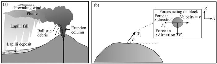
Mastin, L. G., 2001. A Simple Calculator of Ballistic Trajectories for Blocks Ejected during Volcanic Eruptions. U. S. Geological Survey Open-File Report 01-45. 16. |
Mastrolorenzo, G., Pappalardo, L., Troise, C., et al., 2008. Probabilistic Tephra Hazard Maps for the Neapolitan Area: Quantitative Volcanological Study of Campi Flegrei Eruptions. Journal of Geophysical Research: Solid Earth, 113(B7): B07203. https://doi.org/10.1029/2007jb004954 |
McLean, D., Albert, P. G., Nakagawa, T., et al., 2018. Integrating the Holocene Tephrostratigraphy for East Asia Using a High-Resolution Cryptotephra Study from Lake Suigetsu (SG14 Core), Central Japan. Quaternary Science Reviews, 183: 36–58. https://doi.org/10.1016/j.quascirev.2017.12.013 |
Newhall, C., Hoblitt, R., 2002. Constructing Event Trees for Volcanic Crises. Bulletin of Volcanology, 64(1): 3–20. https://doi.org/10.1007/s004450100173 |
Nie, B. F., 2006. Study of Qixiangzhan Silicic Lava Flow of Tianchi Volcano in Changbaishan Area: [Dissertation]. Capital Normal University, Beijing (in Chinese with English Abstract) |
Oppenheimer, C., 2011. Eruptions that Shook the World: Large Eruptions. Cambridge University Press, Cambridge |
Oppenheimer, C., Wacker, L., Xu, J. D., et al., 2017. Multi-Proxy Dating the 'Millennium Eruption' of Changbaishan to Late 946 CE. Quaternary Science Reviews, 158: 164–171. https://doi.org/10.1016/j.quascirev.2016.12.024 |
Pan, B., Cheng, T., Wan, Y., et al., 2017a. Study of the Lava Flow Hazard Zoning Based on the Kinematic Thermo-Rheological Model: Example Study for the Ashikule Volcano, Xinjiang. Seismology and Geology, 39(4): 721–734 (in Chinese with English Abstract) |
Pan, B., de Silva, S. L., Xu, J. D., et al., 2017b. The VEI-7 Millennium Eruption, Changbaishan-Tianchi Volcano, China/DPRK: New Field, Petrological, and Chemical Constraints on Stratigraphy, Volcanology, and Magma Dynamics. Journal of Volcanology and Geothermal Research, 343: 45–59. https://doi.org/10.1016/j.jvolgeores.2017.05.029 |
Pan, B., de Silva, S. L., Xu, J. D., et al., 2020. Late Pleistocene to Present Day Eruptive History of the Changbaishan-Tianchi Volcano, China/DPRK: New Field, Geochronological and Chemical Constraints. Journal of Volcanology and Geothermal Research, 399: 106870. https://doi.org/10.1016/j.jvolgeores.2020.106870 |
Pan, B., Liu, G. M., Cheng, T., et al., 2021. Development and Status of Active Volcano Monitoring in China. Geological Society, London, Special Publications, 510(1): 227–252. https://doi.org/10.1144/sp510-2020-62 |
Ragona, M., Hansstein, F., Mazzocchi, M., 2011. The Financial Impact of the Volcanic Ash Crisis on the European Airline Industry. In: Alemanno, A., ed., Governing Disasters. Edward Elgar Publishing. |
Scarpa, R., Tilling, R. I., 1996. Monitoring and Mitigation of Volcano Hazards. Springer Berlin Heidelberg |
Sheridan, M. F., Macías, J. L., 1992. PC Software for 2-Dimensional Gravity-Driven Flows: Application to Colima and El Chichón Volcanoes, México, Proc. Second International Meeting on Volcanology, Colima, México. 5 |
Sheridan, M. F., Hubbard, B., Carrasco-Núñez, G., et al., 2004. Pyroclastic Flow Hazard at Volcán Citlaltépetl. Natural Hazards, 33(2): 209–221. https://doi.org/10.1023/b:nhaz.0000037028.89829.d1 |
Stothers, R. B., 1984. The Great Tambora Eruption in 1815 and Its Aftermath. Science, 224(4654): 1191–1198. https://doi.org/10.1126/science.224.4654.1191 |
Sun, C. Q., Plunkett, G., Liu, J. Q., et al., 2014. Ash from Changbaishan Millennium Eruption Recorded in Greenland Ice: Implications for Determining the Eruption's Timing and impact. Geophysical Research Letters, 41: 694–701. https://doi.org/10.1002/2013gl058642 |
Sun, C. Q., Liu, J. Q., You, H. T., et al., 2017. Tephrostratigraphy of Changbaishan Volcano, Northeast China, since the Mid-Holocene. Quaternary Science Reviews, 177: 104–119. https://doi.org/10.1016/j.quascirev.2017.10.021 |
Sun, C. Q., Wang, L., Plunkett, G., et al., 2018. Ash from the Changbaishan Qixiangzhan Eruption: A New Early Holocene Marker Horizon across East Asia. Journal of Geophysical Research: Solid Earth, 123(8): 6442–6450. https://doi.org/10.1029/2018jb015983 |
Sun, Z., Li. F. C., Lin, J., et al., , 2021. The Rifting-Breakup Process of the Passive Continental Margin and Its Relationship with Magmatism: The Attribution of the South China Sea. Earth Science, 46(3): 770–789. https://doi.org/10.3799/dqkx.2020.371 (in Chinese with English Abstract) |
Suzuki, T., 1983. A Theoretical Model for Dispersion of Tephra. In: Shimozuru, D., Yokoyama, I., eds., Volcanism: Physics and Tectonics. Arc, Tokyo. 95–113 |
Tilling, R. I., 2005. Volcano Hazards. In: Marti, J., Ernst, G. G. J., eds. Volcanoes and the Environment. Cambridge University Press, Cambridge. 55–89. |
Vallance, J. P., Schilling, S. P., Devoll, G., 2001a. Lahar Hazard at Mombacho Volcano, Nicaragua. Geological Survey Open-File Report, 01-455 |
Vallance, J. P., Schilling, S. P., Devoli, G., et al., 2001b. Lahar Hazards at Concepción Volcano, Nicaragua. Geological Survey Open-File Report, 1–457 |
Voight, B., 1990. The 1985 Nevado Del Ruiz Volcano Catastrophe: Anatomy and Retrospection. Journal of Volcanology and Geothermal Research, 44(3/4): 349–386. https://doi.org/10.1016/0377-0273(90)90027-d |
Wei, H. Q., 1991. The Types, Prediction and Control of Volcanic Hazards. Chinese Journal of Geological Hazard and Control, 2(2): 94–96 (in Chinese with English Abstract) |
Wei, H. Q., Bai, Z. D., Li, Z. Y., 2005. Flow Velocity and Hazard Assessment of the Holocene Lava Flows in the Northern Hainan Island. Geological Review, 51(1): 27–35 (in Chinese with English Abstract) |
Wei, H. Q., Liu, G. M., Gill, J., 2013. Review of Eruptive Activity at Tianchi Volcano, Changbaishan, Northeast China: Implications for Possible Future Eruptions. Bulletin of Volcanology, 75(4): 706. https://doi.org/10.1007/s00445-013-0706-5 |
Wright, T. L., Chun, J. Y. F., Esposo, J., et al., 1992. Map Showing Lava-Flow Hazard Zones, Island of Hawai'i. US Geol Surv Misc Field Studies Map MF-2193 |
Wu, J. P., Ming, Y. H., Zhang, H. R., et al., 2007. Earthquake Swarm Activity in Changbaishan Tianchi Volcano. Chinese Journal of Geophysics, 50(4): 1089–1096 (in Chinese with English Abstract) |
Xu, J. D., 2006. The Major Types of Potential Volcanic Hazard of China and Hazard Mapping Technique. Technology for Earthquake Disaster Prevention, 1(3): 266–272 (in Chinese with English Abstract) |
Xu, J. D., Wei, H. Q., Li, N., 2010. Revelations of the Eyjafjallajokull Volcano Eruption in Iceland-Enhancing Active Volcano Monitoring and Research in China Allows of no Delay. Recent Developments in World Seismology, 379: 19–22 (in Chinese with English Abstract) |
Xu, J. D., Liu, G. M., Wu, J. P., et al., 2012. Recent Unrest of Changbaishan Volcano, Northeast China: a Precursor of a Future Eruption? Geophysical Research Letters, 39(16): L16305. https://doi.org/10.1029/2012gl052600 |
Yang, Q. F., Liu, R. X., Wei, H. Q., 2003. Countermeasure for Deduce the Damage in Changbai Mountain Tianchi Volcano. Journal of Seismological Research, 26(2): 183–189 (in Chinese with English Abstract) |
Yang, Q. F., Shi, L. B., Chen, X. D., 2006. Characteristics of Recent of the Changbaishan Tianchi Volcano, China. Seismology and Geology, 28(1): 71–82 (in Chinese with English Abstract) |
Yang, Q. F., Bo, J. S., 2007. Status Quo and Prospects for Research on Tianchi Volcano in Changbai Mountain. Journal of Natural Disasters, 16(6): 133–139 (in Chinese with English Abstract) |
Yang, Q. F., Yuan, X. J., Wu, C. Z., et al., 2018. The Multibeam Sounding Exploration of the Tianchi Caldera Lakebed Topography at the China-North Korea Border. Acta Petrologica Sinica, 34(1): 185–193 (in Chinese with English Abstract) |
Yu, H. M., Xu, J. D., Luan, P., et al., 2013. Probabilistic Assessment of Tephra Fallout Hazard at Changbaishan Volcano, Northeast China. Natural Hazards, 69(3): 1369–1388. https://doi.org/10.1007/s11069-013-0683-1 |
Zhang, J. F., Zhou, Y. S., Song, M. S., 2022. Development Status and Trends of Experimental Rheology. Earth Science, 47(8): 2744. https://doi.org/10.3799/dqkx.2022.301 (in Chinese with English Abstract) |
Zhao, B., Xu, J. D., Yu, H. M., et al., 2020. Pyroclastic Density Current Facies in the Millennium Eruption of Tianchi Volcano, Northeast China: Insights from Topography, Stratigraphy, Granulometry, and Petrography. Frontiers in Earth Science, 8: 323. https://doi.org/10.3389/feart.2020.00323 |
Parameters | Parameters of millennium eruption | Parameters of simulations | ||
Column height (km) | 35 | 10 | 20 | 30 |
Eruption volume (km3) | 120 | 50 | 100 | 120 |
Eruption velocity (m/s) | 300 | 100 | 200 | 300 |
Eruption temperature (℃) | 780 | 780 | 780 | 780 |
Intermediate particle diameter (cm) | 0.13 | 0.13 | 0.13 | 0.13 |
Minimum particle diameter (cm) | 0.006 | 0.006 | 0.006 | 0.006 |
Maximum particle diameter (cm) | 3 | 3 | 3 | 3 |
Particle variance (σd) | 1.12 | 1.12 | 1.12 | 1.12 |
Ash density (g/cm3) | 1 | 1 | 1 | 1 |
Shape parameter | 0.5 | 0.5 | 0.5 | 0.5 |
β | 0.01 | 0.5 | 0.1 | 0.01 |
Effusive ratio (m3/s) | No. 15 | No. 14 | No. 13 | No. 12 | No. 11 | No. 10 | No. 9 | No. 8 |
100 | 2 951 | 3 620 | 3 791 | 2 711 | 2 664 | 3 267 | 3 220 | 3 320 |
200 | 6 212 | 6 498 | 5 866 | 5 807 | 5 447 | 4 648 | 4 772 | 6 208 |
350 | 9 956 | 12 951 | 12 121 | 12 388 | 10 541 | 9 751 | 6 127 | 7 965 |
500 | 16 282 | 16 512 | 16 827 | 17 190 | 15 741 | 12 271 | 9 752 | 10 448 |
Effusive ratio (m3/s) | No. 8 | No. 7 | No. 6 | No. 5 | No. 4 | No. 3 | No. 2 | No. 1 |
100 | 3 320 | 2 721 | 2 045 | 2 369 | 3 201 | 3 351 | 3 611 | 2 191 |
200 | 6 208 | 5 678 | 3 595 | 5 411 | 5 422 | 6 578 | 6 231 | 4 201 |
350 | 7 965 | 7 856 | 9 606 | 9 760 | 9 327 | 11 101 | 10 548 | 8 475 |
500 | 10 448 | 12 522 | 16 892 | 14 584 | 14 689 | 15 618 | 15 090 | 13 347 |
Lahar volume (m3) | Erdaobaihe River (km) | Yalu River (km) | Tumen River (km) | Songhua River (km) |
108 | 40 | 48 | 60 | 60 |
109 | 70 | 55 | 80 | 90 |
1010 | 85 | 63 | 105 | 110 |
1011 | 100 | 80 | 120 | 130 |
Tephra | Lava | Pyroclastic flow | Lahar | Damage strength | Respose time (min) | |||||||||||
Column height | Value | Effusive rate | Value | Column height | Value | Volume | Value | Level | Value | Time | Value | |||||
30 km | 0.4 | 500 m2/s | 0.4 | 30 km | 0.6 | 100 km2 | 0.2 | Affect | 0.3 | > 20 | 0.3 | |||||
20 km | 0.6 | 350 m2/s | 0.6 | 20 km | 0.8 | 10 km2 | 0.4 | Break | 0.6 | 10–20 | 0.6 | |||||
10 km | 0.8 | 200 m2/s | 0.8 | 10 km | 1.0 | 1 km2 | 0.6 | Damage | 0.8 | 3–10 | 0.8 | |||||
Ballistic | 1.0 | 100 m2/s | 1.0 | 0.1 km2 | 0.8 | Destroy | 1.0 | < 3 | 1.0 |