| Citation: | Qi Yu, Xianyan Wang, Zhiyong Han, Xiaodong Miao, Huayu Lu. Diverse Climatic and Anthropogenic Impacts on Desertification in the Middle Reaches of Yarlung Zangbo River Catchment on the Tibetan Plateau. Journal of Earth Science, 2023, 34(6): 1816-1826. doi: 10.1007/s12583-022-1658-5

|
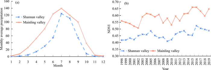
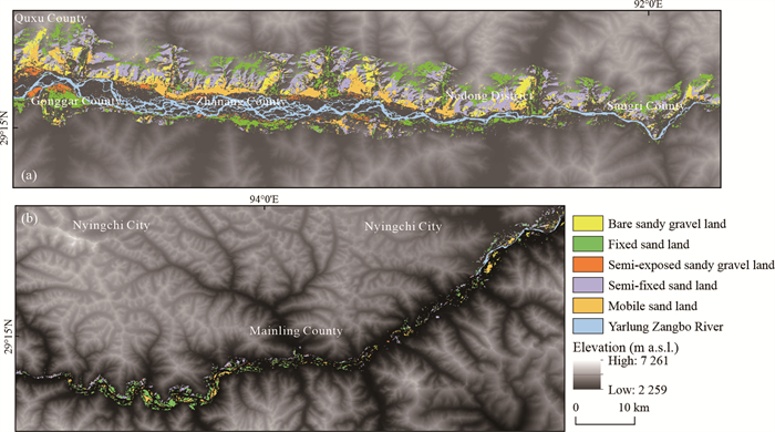
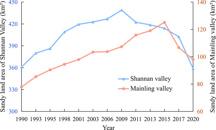
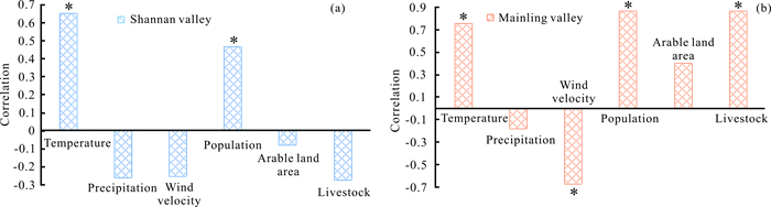
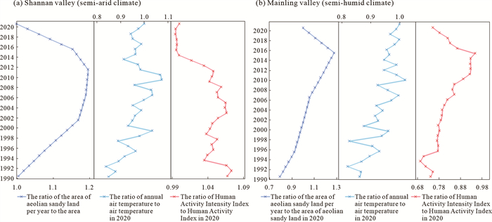
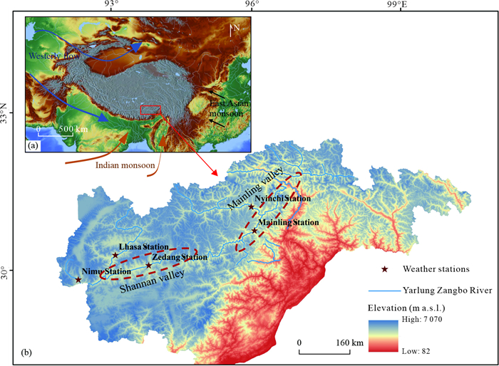
The unique desertification processes occurring under the Alpine climate and ecosystem on the Tibetan Plateau could provide critical clues to the natural and anthropogenic impacts on desertification. This study used the Landsat data to investigate the spatial and temporal distribution of desertification from 1990 to 2020 in two areas (Shannan and Mainling), within the Yarlung Zangbo River Basin. The results show not only distinct spatial patterns but also various temporal changes of desertification. In Shannan, aeolian sand was distributed over wide areas from valley floor to mountain slope, while in Mainling, it is distributed sporadically at the footslope. The aeolian sandy land initially expanded before undergoing long-term shrinkage in Shannan. While in Mainling, it steadily expanded followed by a rapid decrease. These changes are attributed to both climate change and human activites. The increase in temperature causes desertification expansion in Shannan, while favorable climate conditions coupled with decreasing human activity promoted desertification reversal. However, both the expansion and shrinkage of desertification were sensitive to human activity in Mainling. This highlights the diverse responses of desertification to natural and anthropogenic impacts on different backgrounds of climatic and vegetation coverage. A threshold of climatic conditions may control the dominance factors in desertification, shifting from natural to anthropogenic elements.

| Ajaj, Q. M., Pradhan, B., Noori, A. M., et al., 2017. Spatial Monitoring of Desertification Extent in Western Iraq Using Landsat Images and GIS. Land Degradation & Development, 28(8): 2418–2431. https://doi.org/10.1002/ldr.2775 |
| Chang, C. P., Zhou, X. R., Zhang, C. L., et al., 2006. The Characteristics and Distribution of the Source Area of Aeolian Sand in the Valley of Lhasa River's Lower Reaches, Tibet, China. Mountain Research, 24(4): 489–497. https://doi.org/10.1109/igarss.2006.791 |
| Cheng, W. M., Zhao, S. M., Zhou, C. H., et al., 2012. Simulation of the Decadal Permafrost Distribution on the Qinghai-Tibet Plateau (China) over the Past 50 Years. Permafrost and Periglacial Processes, 23(4): 292–300. https://doi.org/10.1002/ppp.1758 |
| Cong, N., Shen, M. G., Yang, W., et al., 2017. Varying Responses of Vegetation Activity to Climate Changes on the Tibetan Plateau Grassland. International Journal of Biometeorology, 61(8): 1433–1444. https://doi.org/10.1007/s00484-017-1321-5 |
| Deng, S. B., 2010. ENVI Remote Sensing Image Processing Method. Science Press, Beijing. 54–164 (in Chinese) |
| Dong, Y. X., Li, S., Dong, G. R., 1999. Present Status and Cause of Land Desertification in the Yarlung Zangbo River Basin. Chinese Geographical Science, 9(3): 228–235. https://doi.org/10.1007/s11769-999-0048-6 |
| Dong, Z. B., Hu, G. Y., Qian, G. Q., et al., 2017. High-Altitude Aeolian Research on the Tibetan Plateau. Reviews of Geophysics, 55(4): 864–901. https://doi.org/10.1002/2017rg000585 |
| Guo, Y., Song, Z. Z., Ma, L., et al., 2021. Class-Wise Feature Alignment Based Transfer Network for Multi-Temporal Remote Sensing Image Classification. Earth Science, 46(10): 3730–3739. https://doi.org/10.3799/dqkx.2020.347 (in Chinese with English Abstract) |
| Guo, Z. L., Huang, N., Dong, Z. B., et al., 2014. Wind Erosion Induced Soil Degradation in Northern China: Status, Measures and Perspective. Sustainability, 6(12): 8951–8966. https://doi.org/10.3390/su6128951 |
| Hai, C. X., Ma, L., Wang, X. M., et al., 2002. Main Factors Analysis about Soil Desertification in Typical Section of Interlock Area of Farming and Pasturing: The Case of Zhangbei County——Bashang Area of Hebei Province. Geographical Research, 21(5): 543–550 (in Chinese with English Abstract) |
| Huang, J. P., Zhang, G. L., Zhang, Y. T., et al., 2020. Global Desertification Vulnerability to Climate Change and Human Activities. Land Degradation & Development, 31(11): 1380–1391. https://doi.org/10.1002/ldr.3556 |
| Immerzeel, W. W., van Beek, L. P. H., Bierkens, M. F. P., 2010. Climate Change will Affect the Asian Water Towers. Science, 328(5984): 1382–1385. https://doi.org/10.1126/science.1183188 |
| Jiang, G. Z., Han, B., Gao, Y. B., et al., 2013. Review of 40-Year Earth Observation with Landsat Series and Prospects of LDCM. National Remote Sensing Bulletin, 17(5): 1033–1048. https://doi.org/10.11834/jrs.20132296 |
| Li, J. C., Wang, Y., Zhang, L. S., et al., 2019. Aeolian Desertification in China's Northeastern Tibetan Plateau: Understanding the Present through the Past. CATENA, 172: 764–769. https://doi.org/10.1016/j.catena.2018.09.039 |
| Li, J. C., Yao, Q., Zhou, N., et al., 2020. Modern Aeolian Desertification on the Tibetan Plateau under Climate Change. Land Degradation & Development, 32(5): 1908–1916. https://doi.org/10.1002/ldr.3862 |
| Li, Q., Zhang, C. L., Shen, Y. P., et al., 2016a. Quantitative Assessment of the Relative Roles of Climate Change and Human Activities in Desertification Processes on the Qinghai-Tibet Plateau Based on Net Primary Productivity. CATENA, 147: 789–796. https://doi.org/10.1016/j.catena.2016.09.005 |
| Li, Q., Zhang, C. L., Shen, Y. P., et al., 2016b. Developing Trend of Aeolian Desertification in China's Tibet Autonomous Region from 1977 to 2010. Environmental Earth Sciences, 75(10): 1–12. https://doi.org/10.1007/s12665-016-5709-z |
| Li, S., Dong, G., Shen, J. Y., et al., 1999. Formation Mechanism and Development Pattern of Aeolian Sand Landform in Yarlung Zangbo River Valley. Science in China Series D: Earth Sciences, 42(3): 272–284. https://doi.org/10.1007/bf02878964 |
| Li, S., Wang, Y., Ha, S., et al., 1997. Classification and Development of Aeolian Sand Landform in the Yarlung Zangbo Valley. Journal of Desert Research, 17(4): 342–350 (in Chinese with English Abstract) |
| Li, S., Yang, P., Dong, Y. X., et al., 2010. Land Desertification and Its Control in Tibet. Science Press, Beijing. 77–157 (in Chinese) |
| Ling, Z. Y., Jin, J. H., Wu, D., et al., 2019. Aeolian Sediments and Their Paleoenvironmental Implication in the Yarlung Zangbo Catchment (Southern Tibet, China) since MIS3. Acta Geographica Sinica, 74(11): 2385–2400. https://doi.org/10.11821/dlxb201911014 (in Chinese with English Abstract) |
| Ling, Z. Y., Yang, S. L., Wang, X., et al., 2020. Spatial-Temporal Differentiation of Eolian Sediments in the Yarlung Tsangpo Catchment, Tibetan Plateau, and Response to Global Climate Change since the Last Glaciation. Geomorphology, 357: 107104. https://doi.org/10.1016/j.geomorph.2020.107104 |
| Liu, J. G., Diamond, J., 2005. China's Environment in a Globalizing World. Nature, 435(7046): 1179–1186. https://doi.org/10.1038/4351179a |
| Liu, L. Y., Liu, Z. M., Wang, J. H., et al., 1997. Sand Source of Sand Dune and Modern Desertification Process in Jiandang Wide Valley Area of Yarlung Zangbo River. Journal of Desert Research, 17(4): 377–382 (in Chinese with English Abstract). |
| Liu, Y., Wang, Y. S., Shen, T., 2019. Spatial Distribution and Formation Mechanism of Aeolian Sand in the Middle Reaches of the Yarlung Zangbo River. Journal of Mountain Science, 16(9): 1987–2000. https://doi.org/10.1007/s11629-019-5509-5 |
| Lyu, Y. L., Shi, P. J., Han, G. Y., et al., 2020. Desertification Control Practices in China. Sustainability, 12(8): 3258. https://doi.org/10.3390/su12083258 |
| Mirzabaev, A., Annagylyjova, J., Amirova, I., 2019. The Aral Sea Basin: Water for Sustainable Development in Central Asia, Chapter: Environmental Degradation. Routledge, London. 66–85. https://doi.org/10.4324/9780429436475 |
| Moghaddam, M. H. R., Sedighi, A., Fasihi, S., et al., 2018. Effect of Environmental Policies in Combating Aeolian Desertification over Sejzy Plain of Iran. Aeolian Research, 35: 19–28. https://doi.org/10.1016/j.aeolia.2018.09.001 |
| Na, R. S., Du, H. B., Na, L., et al., 2019. Spatiotemporal Changes in the Aeolian Desertification of Hulunbuir Grassland and Its Driving Factors in China during 1980–2015. CATENA, 182: 104123. https://doi.org/10.1016/j.catena.2019.104123 |
| Rasmussen, K., Fog, B., Madsen, J. E., 2001. Desertification in Reverse? Observations from Northern Burkina Faso. Global Environmental Change, 11(4): 271–282. https://doi.org/10.1016/s0959-3780(01)00005-x |
| Reynolds, J. F., Smith, D. S., Lambin, E. F., et al., 2007. Global Desertification: Building a Science for Dryland Development. Science, 316(5826): 847–851. https://doi.org/10.1126/science.1131634 |
| Shen, W. S., Li, H. D., Sun, M., et al., 2012. Dynamics of Aeolian Sandy Land in the Yarlung Zangbo River Basin of Tibet, China from 1975 to 2008. Global and Planetary Change, 86/87: 37–44. https://doi.org/10.1016/j.gloplacha.2012.01.012 |
| Shen, W. S., Li, H. D., 2012. Remote-Sensing Monitoring and Ecological Restoration on Aeolian Sandy Land in the Yarlung Zangbo River Basin on the Tibetan Plateau. China Environmental Press, Beijing. 3–12 (in Chinese) |
| Shen, W. S., Zhao, W., Wang, X. D., et al., 2015. Study on Ecological Carrying Capacity and Sustainable Development in Tibet. China Environmental Press, Beijing. 20–42 (in Chinese) |
| Shi, X. N., Zhang, F., Lu, X. X., et al., 2018. Spatiotemporal Variations of Suspended Sediment Transport in the Upstream and Midstream of the Yarlung Tsangpo River (the Upper Brahmaputra), China. Earth Surface Processes and Landforms, 43(2): 432–443. https://doi.org/10.1002/esp.4258 |
| Wang, F., Pan, X. B., Wang, D. F., et al., 2013. Combating Desertification in China: Past, Present and Future. Land Use Policy, 31: 311–313. https://doi.org/10.1016/j.landusepol.2012.07.010 |
| Wang, T., Zhu, Z. D., Wu, W., 2002. Sandy Desertification in the North of China. Science in China Series D: Earth Sciences, 45(1): 23–34. https://doi.org/10.1007/bf02878385 |
| Wang, X., Chen, F. H., Dong, Z., et al., 2005. Evolution of the Southern Mu US Desert in North China over the Past 50 Years: An Analysis Using Proxies of Human Activity and Climate Parameters. Land Degradation & Development, 16(4): 351–366. https://doi.org/10.1002/ldr.663 |
| Wang, X. M., Zhang, C. X., Hasi, E., et al., 2010. Has the Three Norths Forest Shelterbelt Program Solved the Desertification and Dust Storm Problems in Arid and Semiarid China? Journal of Arid Environments, 74(1): 13–22. https://doi.org/10.1016/j.jaridenv.2009.08.001 |
| Wang, X. M., Yang, Y., Dong, Z. B., et al., 2009. Responses of Dune Activity and Desertification in China to Global Warming in the Twenty-First Century. Global and Planetary Change, 67(3/4): 167–185. https://doi.org/10.1016/j.gloplacha.2009.02.004 |
| Wang, Z. H., Lin, W. L., Ding, R. X., 2018. Quantitative Measurement of Bedding Orientation Using Remote Sensing Data: Yili Basin, Northwest China. Journal of Earth Science, 29(3): 689–694. https://doi.org/10.1007/s12583-017-0943-1 |
| Wang, Z. Y., Li, Z. W., Xu, M. Z., et al., 2016. River Morphodynamics and Stream Ecology of the Qinghai-Tibet Plateau. CRC Press/Balkema, Boca Raton. 45–52 |
| Xu, D. Y., Ding, X., 2018. Assessing the Impact of Desertification Dynamics on Regional Ecosystem Service Value in North China from 1981 to 2010. Ecosystem Services, 30(A): 172–180. https://doi.org/10.1016/j.ecoser.2018.03.002 |
| Xu, D. Y., Li, C. L., Song, X., et al., 2014. The Dynamics of Desertification in the Farming-Pastoral Region of North China over the Past 10 Years and Their Relationship to Climate Change and Human Activity. CATENA, 123: 11–22. https://doi.org/10.1016/j.catena.2014.07.004 |
| Xu, D. Y., Kang, X. W., Qiu, D. S., et al., 2009. Quantitative Assessment of Desertification Using Landsat Data on a Regional Scale—A Case Study in the Ordos Plateau, China. Sensors, 9(3): 1738–1753. https://doi.org/10.3390/s90301738 |
| Xu, Z. W., Lu, H. Y., 2021. Aeolian Environmental Change Studies in the Mu Us Sandy Land, North-Central China: Theory and Recent Progress. Acta Geographica Sinica, 76: 1–23. https://doi.org/10.11821/dlxb202109012 (in Chinese with English Abstract) |
| Xue, W., 2014. Statistical Analysis and SPSS Application. China Renmin University Press, Beijing. 209–260 (in Chinese) |
| Xue, X., Guo, J., Han, B. S., et al., 2009. The Effect of Climate Warming and Permafrost Thaw on Desertification in the Qinghai-Tibetan Plateau. Geomorphology, 108(3/4): 182–190. https://doi.org/10.1016/j.geomorph.2009.01.004 |
| Yang, J. H., Xia, D. S., Gao, F. Y., et al., 2020a. Aeolian Deposits in the Yarlung Zangbo River Basin, Southern Tibetan Plateau: A Brief Review. Advances in Earth Science, 35(8): 863–877 (in Chinese with English Abstract) |
| Yang, J. H., Xia, D. S., Wang, S. Y., et al., 2020b. Near-Surface Wind Environment in the Yarlung Zangbo River Basin, Southern Tibetan Plateau. Journal of Arid Land, 12(6): 917–936. https://doi.org/10.1007/s40333-020-0104-8 |
| Yang, M. X., Nelson, F. E., Shiklomanov, N. I., et al., 2010. Permafrost Degradation and Its Environmental Effects on the Tibetan Plateau: A Review of Recent Research. Earth-Science Reviews, 103(1/2): 31–44. https://doi.org/10.1016/j.earscirev.2010.07.002 |
| Yang, Y. C., 1984. Aeolian Landform on the Banks of River Valley—Case Study on Yarlung Zangbo River Valley. Journal of Desert Research, 4(3): 12–15 (in Chinese with English Abstract) |
| Yao, T. D., Li, Z. G., Yang, W., et al., 2010. Glacial Distribution and Mass Balance in the Yarlung Zangbo River and Its Influence on Lakes. Chinese Science Bulletin, 55(20): 2072–2078. https://doi.org/10.1007/s11434-010-3213-5 |
| Yao, T. D., Piao, S. L., Shen, M. G., et al., 2017. Chained Impacts on Modern Environment of Interaction between Westerlies and Indian Monsoon on Tibetan Plateau. Bulletin of Chinese Academy of Sciences, 32(9): 976–984 (in Chinese with English Abstract) |
| Yao, T. D., Zhu, L. P., 2006. The Response of Environmental Changes on Tibetan Plateau to Global Changes and Adaptation Strategy. Advances in Earth Science, 21(5): 459–464 (in Chinese with English Abstract) |
| Zeng, H. W., Wu, B. F., Zhang, M., et al., 2021. Dryland Ecosystem Dynamic Change and Its Drivers in Mediterranean Region. Current Opinion in Environmental Sustainability, 48: 59–67. https://doi.org/10.1016/j.cosust.2020.10.013 |
| Zhao, W. Z., Xiao, H. L., Liu, Z. M., et al., 2005. Soil Degradation and Restoration as Affected by Land Use Change in the Semiarid Bashang Area, Northern China. CATENA, 59(2): 173–186. https://doi.org/10.1016/j.catena.2004.06.004 |
| Zhao, Y. B., He, Z. W., Ni, Z. Y., et al., 2012. Spatial Feature of Desertification in Qushui-Naidong Area of Yarlung Zangbo River. Journal of Arid Land Resources and Environment, 26(8): 135–140 (in Chinese with English Abstract) |
| Zhou, N., Zhang, C. L., Wu, X. X., et al., 2014. The Geomorphology and Evolution of Aeolian Landforms within a River Valley in a Semi-Humid Environment: A Case Study from Mainling Valley, Qinghai-Tibet Plateau. Geomorphology, 224: 27–38. https://doi.org/10.1016/j.geomorph.2014.07.012 |
| Zhu, Z. D., Chen, G. T., et al., 1994. Sandy Desertification in China. Science Press, Beijing. 217–233 (in Chinese) |
Figures(7) / Tables(1)
Copyright © 2013-2020 Journal of Earth Science 鄂ICP备15021562号-2
Tel: +86-27-67885075 Fax: +86-27-67885075 E-mail: xbb@cug.edu.cn
Address: Editorial Office of Journal, China University of Geosciences, Yujiashan, Wuhan, Hubei 430074, P. R. China
Supported by:
Beijing Renhe Information Technology Co. Ltd
E-mail:
info@rhhz.net


 DownLoad: