Advanced Search

Indexed by SCI、CA、РЖ、PA、CSA、ZR、etc .

Yong Yue, Jingchun Tian, Chuanyan Huang. Formation Mechanism of the Paleocene Basal Conglomerate, Southwest Tarim Basin. Journal of Earth Science, 2024, 35(5): 1513-1526. doi: 10.1007/s12583-022-1696-z
Citation: Yong Yue, Jingchun Tian, Chuanyan Huang. Formation Mechanism of the Paleocene Basal Conglomerate, Southwest Tarim Basin. Journal of Earth Science, 2024, 35(5): 1513-1526. doi: 10.1007/s12583-022-1696-z

Formation Mechanism of the Paleocene Basal Conglomerate, Southwest Tarim Basin

doi: 10.1007/s12583-022-1696-z
More Information
  • Corresponding author: Yong Yue, 284434090@qq.com
  • Received Date: 17 Jul 2021
  • Accepted Date: 07 Jun 2022
  • Issue Publish Date: 30 Oct 2024
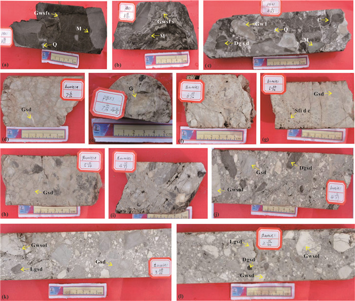
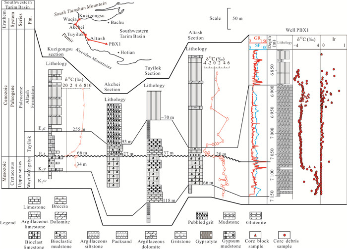
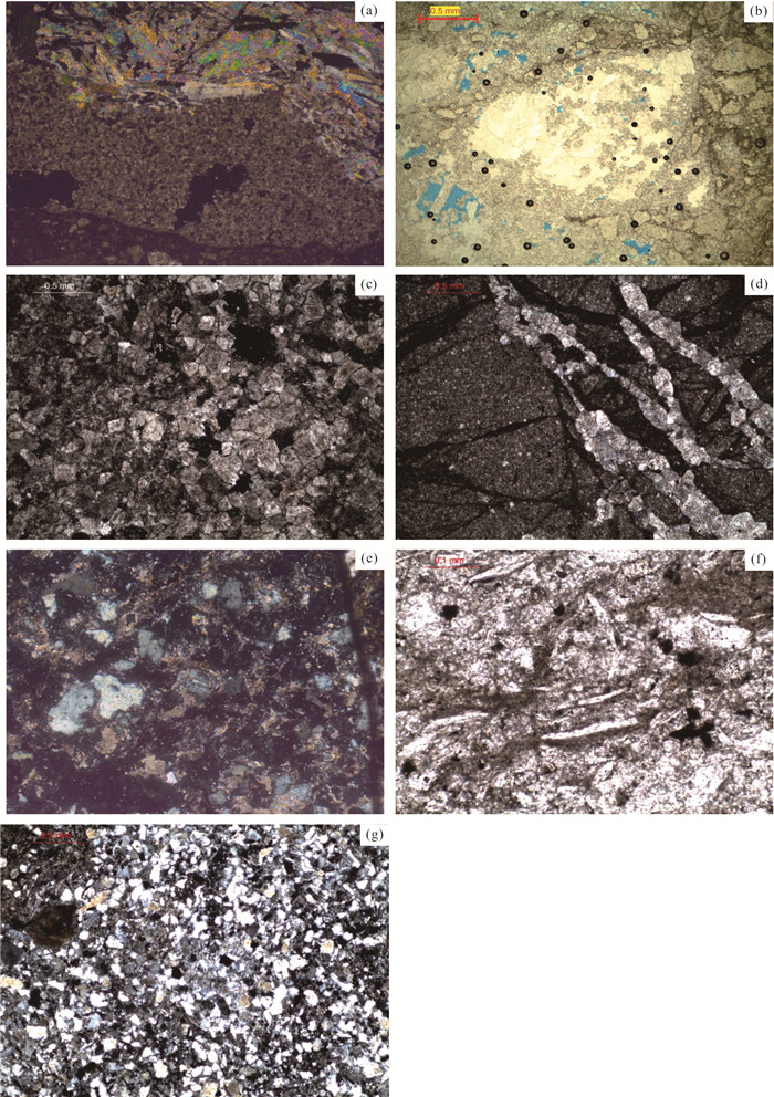
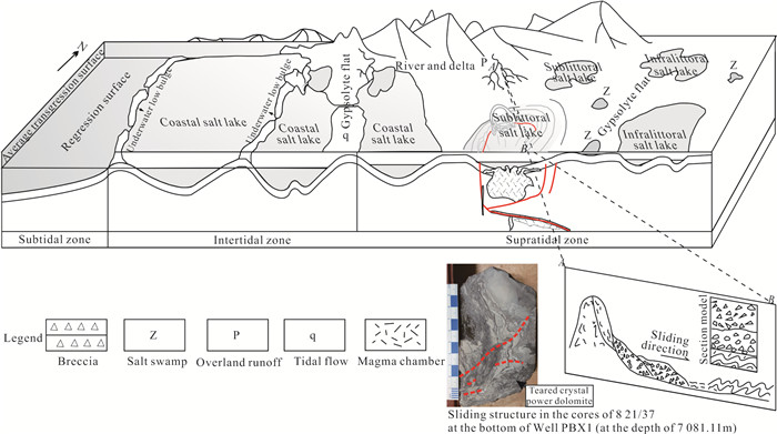
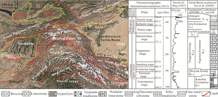
  • Most knowledge about the Cretaceous–Paleogene strata in the Tarim Basin is mainly inferred from the outcrops at the basin's margin, but first time in the basin. The formation mechanism of the Paleocene basal conglomerate was determined using geochemical isotopes of the breccia from Well PBX1 in the southwestern Tarim Basin. The results showed that the global K/Pg (i.e., Cretaceous/Paleogene) clay layer boundary was located in the middle of the Paleocene basal conglomerate at the depth of 7 066.75 m in Well PBX1. In the Late Cretaceous, associated with volcanic activities and earthquakes, the caldera in the Well PBX1 Block formed an annular depression with large elevation differences in response to the Pamir Block collision. As a result, the collapsed breccia with storm tide genesis deposited at the periphery and inside of the depression, characterized by syn-sedimentary deformation. During the Paleocene, multiple sets of interbedded carbonate and collapsed breccia deposited in response to multi-phased transient transgression-regression cycles. The transportation of breccia exhibited near-source accumulation/extremely close or in-situ rapid accumulation. The studied region is located in the eastern end of the Tethys Sea, the Late Cretaceous–Early Paleocene breccia is of great significance for reconstructing the paleogeography of the Tarim basin in Tethys.


  • Conflict of Interest
    The authors declare that they have no conflict of interest.
  • The southwestern part of the Tarim Basin (hereinafter referred to as the southwestern Tarim Basin) is located at the northern margin of the Neo-Tethys Ocean and the eastern margin of the southern Eurasian continent. During the Cretaceous–Paleogene, it was a foreland basin bounded by the South Tianshan and the West Kunlun Mountain, where Cretaceous–Paleogene marine strata are the most extensively distributed as a result of paralic deposition (Li et al., 2002). Affected by the action retardation, large-scale Neo-Tethys transgression of Late Cretaceous–Paleogene, the Neogene closure of the Neo-Tethys Ocean and the intense uplifting of the Qinghai-Tibet Plateau, the subsidence and depositional centers migrated frequently, the lithofacies changed rapidly and the strata were complicated in the southwestern Tarim Basin (Yue et al., 2017). There has been little research on the southwestern Tarim Basin since its most area was covered by desert (Lü et al., 2016). Although all the exploration wells target at the Lower Paleozoic penetrated Paleogene strata, only Well PBX1 cored a set of breccia deposits (Li et al., 2019; Yue et al., 2019). Comparing with surrounding strata, it was found that the drilled breccia was significantly different from that of the South Tianshan and Kunlun Mountain. The analysis of the breccia strata are of great significance for determining the chronological sequence of the southwestern Tarim Basin, analyzing the Early Paleocene climate environment in the northern Tethys Sea, and reconstructing the paleoenvironment of the northern Tethys Basin group.

    During the Cretaceous–Paleogene period, the southwestern Tarim Basin was connected with the Alai Basin, Fergana Basin and Tajik Basin in the Central Asia. The southwestern Tarim Basin is in a shape of horn mouth from east to west, which constitutes the eastern epicontinental sea (Tajik Sea) intruded from the northern margin of the Tethys Ocean to the southern Eurasia continent during the Late Cretaceous–Paleogene Eocene global sea level rise period (Bosboom et al., 2011). The southwestern Tarim Basin was located in the east of Pamir Tuci, jointed with the Alai Basin (valley) on the north of the Pamirs and the Tajik Basin on the west, facing the Fergana Basin by the South Tianshan Mountain (Figure 1). In the Paleocene, the Indian Plate began to collide with the Eurasian Plate, the Pamir Tuci became embryonic form. During the Oligocene–Miocene, the Tuci collided and compressed northward, the intracontinental orogenic movement of the Kunlun Mountain and Tianshan Mountain became more intense. As a result, the prototype of the Shache uplift formed.

    Figure  1.  Tectonic setting and stratigraphic colomn in the southwestern Tarim Basin.

    Since the Pliocene, affected by the intense (hard) collision between the Indian Plate and the Eurasian Continent, intracontinental orogenic movement took place in the Kunlun Mountain and the Tianshan Mountain. As a result, Pamir Tuci strongly displaced, uplifted and overthrew northward (Bosboom et al., 2014; Zhang et al., 2007), forming the distinctive features of the Pamir Plateau squeezing northward as a form of spike strike. In the process of sedimentary evolution, the southwestern Tarim Basin was one part of the Tarim Craton in the Paleozoic. The southwestern Tarim Basin uplifted at the end of the Late Permian and there was a depositional break during the Triassic. During the Jurassic–Early Cretaceous, the southwestern Tarim Basin evolved to an interior basin. During the Late Cretaceous–Paleogene, it became a restricted sea basin dominated by bays and deltas once again. Until the Neogene, the southwestern Tarim Basin completed the environmental change from sea to continent (Fang et al., 2009). Especially during the Cretaceous–Paleogene period, the seawater of Tethys invaded into the Tarim Basin through the Alai Strait in the west. The sediments from the southern Tianshan fold belt in the northern basin and the Kunlun Mountain fold belt in the southern basin accumulated in the depocenter at that time, namely the west of the present southwestern Tarim depression (Yong et al., 1989).

    Based on the characteristics of rock strata, isotopes, and metal elements, the attribution of the Paleogene basal conglomerate in the southwestern Tarim Basin was discussed. A total of 126 samples, including 32 core samples and 94 cutting samples were collected. A total of 170 data points were obtained, including 36 carbon and oxygen isotope data points and 134 cuttings data points (an interval of 2 m).

    A number of tests have been completed on the basis of the statistics of the 6 types of breccias in the sixth coring sections. Among them, the C-O isotope test was completed by the MAT 253 stable isotope mass spectrometer and the Delta advantage oxygen stable isotope mass spectrometer from the Beijing Institute of Geology of the Nuclear Industry. There were 25 Sr isotope samples. The pre-processing and test analysis of the Sr isotope samples were completed by the high-resolution multi-receiving inductively coupled plasma mass spectrometry from the Peking University. Rare metal element test was completed by the plasma mass spectrometer of the National Geological Experiment and Testing Center.

    Well PBX1 in the southwestern Tarim Basin is a representative well encountering Paleocene breccia formation, Paleogene Altash Formation, Zimugen Formation, Karatar Formation, Ulagen Formation, Bashbulak Formation, Neogene Keziluoyi Formation, Anjuan Formation, Pashbulak Formation, Atushi Formation, and Quaternary Xiyu Formation from bottom to top. According to the core characteristics of the basal breccia in Well PBX1, this set of breccias can be roughly divided into three sections from bottom to top.

    Section Ⅰ: It is at the depth of 7 077.94–7 083.27 m form the eighth coring section to the basal dark gray mudstone, with quasi-syngenetic sliding structure mudstone interbedded with siltstone, as Figures 2a2c. Breccia is dominated by silty gray white crystal powder dolomite, accounting for 39%, followed by gray-white sprite calcarenite, accounting for 25%, gray white recrystallized oolitic calcarenite, accounting for 9%, and quasi-syngenetic sliding structure mudstone interbedded with siltstone, accounting for 21%. In addition, there are also quartz and anhydrite breccia, accounting for 6% (Figure 3). Section Ⅱ: It is at the depth of 6 938.17–6 922.14 m in the fourth-seventh coring section. Breccia has relatively single components which are mostly 0.5–2 cm in size, with poor roundness and sorting. Matrix is cemented by small dolomite breccias, as Figures 2d2i. Breccia is dominated by gray-white sprite calcarenite (oolitic limestone) and light gray silty dolomite, accounting for 80%–99%, with minor mudstone, quartz and anhydrite breccia, accounting for 1%–20% (Figure3). Section Ⅲ: It is at the depth of 6 922.14–6 902.00 m in the second-fourth coring section. Breccia has complex components. Which is mostly 0.2–5 cm in size, with poor roundness and sorting as Figures 2j2l. Gray-white sprite (oolitic) limestone accounts for 25%–71%. Light gray silt dolomite accounts for 23%–67%; mudstone, gypsum and quartz account for 23%–67%. As shown in Figures 2a2c, clastic interstitials are dominated by small breccias, such as gray-white sprite (oolitic) limestone, light gray silty dolomite. There are also some mudstone, gypsum and quartz, accounting for 1%–28% (Figure 3).

    Figure  2.  Typical breccia core sample chart of Well PBX1 at the depth of 6 902.00–7 080.66 m. (a) The eighth coring section; (b) the eighth coring section; (c) the eighth coring section; (d) the seventh coring section; (e) the seventh coring section; (f) the sixth coring section; (g) the sixth coring section; (h) the fifth coring section; (i) the fourth coring section; (j) the fourth coring section; (k) the third coring section; (l) the second coring section. Lgsd. Light gray silty dolomite; Dgsd. dark gray silty dolomite; Gwsd. gray white silty dolomite; Gwsol. gray-white sprite (oolitic) limestone; Gsd. gray silty dolomite; Sfidc. siliciclastics filling in dissolved caves; G. gypsum; Gwl. gray-white limestone; C. calcite; Q. quartz; M. mudstone; Gwsfs. gray-white silty-fine sandstone.
    Figure  3.  Breccia percentage chart of Well PBX1 at the depth of 6 902.00–7 083.27 m.

    In the second-seventh coring section of Well PBX1, breccias have various types of components with poor roundness and sorting, but terrigenous materials are few. There are structural fractures formed by early diagenesis in the breccias. Gypsum can be seen by imaging logging data and core in the entire breccia. This type of breccia has the characteristics of rapid accumulation and near source, which may be karst (gypsum) breccia. In the eighth coring section, breccia is larger in size and darker in color. Mudstone is structurally crumpled/slided.

    Stratigraphic correlation is one of the effective methods to determine the stratigraphic attribution. The southwestern Tarim, Karakum, Afghanistan-Tajik and Fergana Basin belong to the same basin group in the northern margin of the Tethys (Jia et al., 2001). These basins deposited interbedded littoral dark marl and coal measures in the Early and Middle Jurassic (Dai and Li, 1995). Since the Late Jurassic, the Black Sea-Caspian remnant ocean basin expanded to the southwestern Tarim depression to the east. Different types of marine sequences deposited from the Cretaceous to the Paleogene (Tong and Xiao, 2003). At the end of the Eocene, the continuous collision of the Indian Plate with Eurasia caused the Pamir area spur northward. As a result, the Gisar uplift appeared, the Kopet Mountain River Alai graben area uplifted, the Karakum Basin, Tajik Basin, Azerbaijan Layi Basin, Fergana Basin and Tarim Basin were separated with each other (Jia et al., 2001). The basin group in the northern margin of the Tethys has a similar genetic sedimentary environment and background during the Late Cretaceous–Eocene. The lithostratigraphic correlation results of the southwestern Tarim Basin were as follows.

    (1) The Paleogene Altash Formation is dominated by thick layered gypsum rock, interbedded with thin limestone and dolomite in the southern Tianshan Mountain and Kunlun Mountain. There is limestone and bioclastic limestone at the top. This stratum is absent in the Fergana Basin at the junction of the three countries, Uzbekistan, Tajikistan and Kyrgyzstan between the Tianshan Mountain and the Gisar-Arai Mountain. (2) The Tuyilok Formation is composed of brown-red gypsum mudstone interbedded with sandy mudstone and brown-red gypsum interbedded with mudstone on the Kuzigongsu section in the southern Tianshan Mountain. It is composed of gray and purple-gray breccia-bearing sandstone in the lower part and purple-red fine sandstone, mudstone, gypsum, fine sandstone with cross bedding in the upper part in the Kunlun Mountain. On the Altash section, it is composed of brick red mudstone interbedded with thin gypsum rock. It is absent in the Fergana Basin. (3) Yue et al. (2016) believes that the Upper Cretaceous Yigeziya Formation is connected with Tajik and represents a long strip along the Kunlun Mountain. In the Tuyilok and Altash section in the Kunlun Mountain, it is mainly composed of medium-thick layered bioclastic limestone, gray and flesh-red medium-thick layered limestone. On the Kuzigongsu section in the Tianshan Mountain, it is composed of gray-green medium-thick layered sandstone, with gray-green, brown-red sandstone interbedded with limestone in the upper and middle part. On the Gara section of the Fergana Basin, it is composed of interbedded gray-white coarse sandstone, brown-red fine sandstone and argillaceous siltstone, with light flesh-red dolomite of several meters thick at the top.

    The basal breccia of Paleogene Altash Formation in Well PBX1 in the southwestern Tarim Basin is not correlated with the Altash Formation in the Tianshan Mountain, but it is correlated to the Tuyilok Formation on the Tuyilok section in the Kunlun Mountain, showing the sedimentary characteristics of clastic rocks. The breccia of Well PBX1 is composed of carbonate rocks containing terrigenous clastics, while the Tuyilok Formation in the Tuyilok section is composed of breccia-bearing sandstone and fine sandstone. It is not well correlated with Cretaceous Yigeziya Formation. The Cretaceous Yigziya Formation is composed of bioclastic limestone in the Tuyilok and Altashi section in the Kunlun Mountain, but it is composed of clastic rocks in the lower part and carbonate rocks in the upper part in the Kuzgongsu section in the Tianshan Mountain and the Gara section in the Fergana Basin. From the end of Late Cretaceous to the Early Paleocene, large-scaled seawater transgression and paleontology extinction result in an abnormally poor biological fossils, so it is difficult to determine the stratigraphic age using paleontological data (Hao, 2001).

    American scholar, Alvarez et al. (1980) found a huge anomaly in the content of the rare metal element iridium (about 30 times higher than the upper and lower horizons) in the clay layer of the K/Pg boundary near Gubbio, Italy. This phenomenon is common at the K/Pg boundary around the world, from the Alaska area in the north to the Antarctic Ocean deep-sea drilling profile in the south, indicating it is a global event (Keller et al., 2003; Schmitz et al., 1988; Schimmelmann and DeNiro, 1984). At the K/Pg boundary around the world, not only iridium, but also platinum group elements have anomalous abundance. In this study, platinum group elements in Well PBX1 were used to look for K/Pg boundary. The core and cuttings samples at the depth of 6 846.00–7 148.00 m were selected. The platinum group elements showed obvious anomalies at the depth of 7 070 m, and their content increases significantly, especially Rh, Ru, Ir, Os, etc. Take the Ir element as an example, its reference content was 0.05 units, but its content was 0.330 units at the depth of 7 070.00 m, which was 6.6 times of the reference content (Table 1, Figure 5). The sampling interval of Well PBX1 was at the depth from 2 to 4 m. The abundance might also be affected by the dilution of the sample. Its maximum content might be higher than the measured data, which might be dozens of times the background value. The K/Pg boundary should be at the depth of about 7 070 m. It is noted that the platinum group elements in cores and cuttings changes greatly in the oil and gas show section at the depth of 6 900–6 950 m and the gypsum salt section at the depth of 6 864–6 848 m. Some samples have higher content and others have base value. There are two possible reasons. One is platinum group elements enrich locally due to the migration, aggregation and extraction of oil and gas, and the enrichment is uneven. Another reason is that in the gypsum salt section, due to the existence of soluble rocks, part dissolution occurs, resulting in mudstone left in the rocks and platinum group element enriched.

    Table  1.  Test results of rare metal elements from core samples in Well PBX1
    Depth (m) Ir (ng/g) Rh (ng/g) Pt (ng/g) Pd (ng/g) Os (ng/g) Sample information Depth (m) Ir (ng/g) Rh (ng/g) Pt (ng/g) Pd (ng/g) Os (ng/g) Sample information
    6 812 0.05 0.03 0.63 0.55 0.09 Cores (whole rock) 6 924 0.02 0.02 0.32 0.25 0.02 Cuttings (whole rock)
    6 902 0.26 0.13 1.29 1.75 0.36 Cores (whole rock) 6 926 0.12 0.08 1.14 1.62 0.47 Cuttings (whole rock)
    6 903 0.03 0.04 0.25 0.55 0.04 Cores (whole rock) 6 928 0.43 0.2 1.78 1.49 1.09 Cuttings (whole rock)
    6 904 0.08 0.05 0.76 0.75 0.1 Cores (whole rock) 6 930 0.07 0.06 0.88 1.22 0.26 Cuttings (whole rock)
    6 906 0.39 0.39 4.41 5.88 0.24 Cores (whole rock) 6 932 0.08 0.08 0.95 1.25 0.11 Cuttings (whole rock)
    6 907 0.04 0.05 0.39 0.78 0.07 Cores (whole rock) 6 934 0.05 0.03 0.4 0.45 0.2 Cuttings (whole rock)
    6 908 0.41 0.18 1.15 2.04 0.86 Cores (whole rock) 6 937 0.06 0.03 0.78 0.73 0.09 Cuttings (whole rock)
    6 908 0.21 0.04 1.29 0.41 0.1 Cores (whole rock) 6 938 0.21 0.09 1.05 1.36 0.48 Cuttings (whole rock)
    6 910 0.03 0.04 0.3 0.8 0.07 Cores (whole rock) 6 939 0.06 0.04 0.74 0.91 0.23 Cuttings (whole rock)
    6 910 0.11 0.07 0.96 1.08 0.2 Cores (whole rock) 6 940 0.05 0.03 0.59 0.42 0.09 Cuttings (whole rock)
    6 912 0.02 0.03 0.83 0.46 0.05 Cores (whole rock) 6 942 0.06 0.03 0.31 0.4 0.15 Cuttings (whole rock)
    6 913 0.02 0.02 0.46 0.31 0.04 Cores (whole rock) 6 946 0.05 0.04 0.34 0.73 0.14 Cuttings (whole rock)
    6 914 0.03 0.02 0.5 0.36 0.07 Cores (whole rock) 6 950 0.06 0.02 0.26 0.47 0.09 Cuttings (whole rock)
    6 915 0.04 0.04 0.34 0.54 0.05 Cores (whole rock) 6 954 0.04 0.02 0.38 0.42 0.09 Cuttings (whole rock)
    6 916 0.13 0.07 0.69 1.04 0.23 Cores (whole rock) 6 958 0.05 0.02 0.37 0.42 0.07 Cuttings (whole rock)
    6 916 0.16 0.08 0.59 0.97 0.29 Cores (whole rock) 6 962 0.05 0.02 0.48 0.5 0.07 Cuttings (whole rock)
    6 918 0.06 0.04 0.58 0.62 0.12 Cores (whole rock) 6 966 0.04 0.03 1.03 0.84 0.08 Cuttings (whole rock)
    6 920 0.1 0.08 1.28 1.29 0.12 Cores (whole rock) 6 970 0.03 0.02 0.72 0.5 0.1 Cuttings (whole rock)
    6 921 0.3 0.07 0.54 0.63 0.9 Cores (whole rock) 6 974 0.04 0.02 0.55 0.42 0.09 Cuttings (whole rock)
    6 922 0.06 0.03 0.52 0.51 0.06 Cores (whole rock) 6 978 0.11 0.02 1.37 0.53 0.2 Cuttings (whole rock)
    6 924 0.08 0.05 0.66 0.81 0.26 Cores (whole rock) 6 982 0.07 0.02 1.06 0.51 0.07 Cuttings (whole rock)
    6 926 0.12 0.08 1.14 1.62 0.47 Cores (whole rock) 6 986 0.06 0.03 0.83 0.8 0.1 Cuttings (whole rock)
    6 928 0.43 0.2 1.78 1.49 1.09 Cores (whole rock) 6 990 0.04 0.02 0.72 0.63 0.27 Cuttings (whole rock)
    6 930 0.07 0.06 0.88 1.22 0.26 Cores (whole rock) 6 994 0.06 0.02 0.46 0.52 0.13 Cuttings (whole rock)
    6 932 0.08 0.08 0.95 1.25 0.11 Cores (whole rock) 6 998 0.05 0.03 1.04 0.81 0.06 Cuttings (whole rock)
    6 933 0.03 0.02 0.23 0.54 0.04 Cores (whole rock) 7 002 0.09 0.02 0.85 0.63 0.1 Cuttings (whole rock)
    6 934 0.03 0.05 0.32 0.82 0.1 Cores (whole rock) 7 006 0.06 0.03 0.92 0.65 0.05 Cuttings (whole rock)
    6 934 0.05 0.03 0.4 0.45 0.2 Cores (whole rock) 7 010 0.11 0.04 0.74 0.62 0.17 Cuttings (whole rock)
    6 937 0.06 0.03 0.78 0.73 0.09 Cores (whole rock) 7 014 0.05 0.03 0.91 0.59 0.08 Cuttings (whole rock)
    6 938 0.21 0.09 1.05 1.36 0.48 Cores (whole rock) 7 018 0.03 0.02 0.56 0.34 0.11 Cuttings (whole rock)
    6 939 0.06 0.04 0.74 0.91 0.23 Cores (whole rock) 7 022 0.1 0.03 1.53 0.99 0.18 Cuttings (whole rock)
    6 940 0.05 0.03 0.59 0.42 0.09 Cores (whole rock) 7 026 0.04 0.02 0.28 0.37 0.13 Cuttings (whole rock)
    6 812 0.05 0.03 0.63 0.55 0.09 Cuttings (whole rock) 7 030 0.03 0.02 0.51 0.56 0.19 Cuttings (whole rock)
    6 848 0.51 0.3 1.74 1.34 0.8 Cuttings (whole rock) 7 034 0.06 0.03 0.69 0.5 0.09 Cuttings (whole rock)
    6 852 0.07 0.03 0.46 0.53 0.07 Cuttings (whole rock) 7 038 0.05 0.02 0.82 0.32 0.09 Cuttings (whole rock)
    6 856 0.25 0.22 0.54 0.91 0.15 Cuttings (whole rock) 7 042 0.02 0.01 0.47 0.25 0.04 Cuttings (whole rock)
    6 860 0.24 0.04 0.46 0.6 0.25 Cuttings (whole rock) 7 046 0.02 0.02 0.45 0.27 0.04 Cuttings (whole rock)
    6 864 0.53 0.06 0.63 0.79 0.25 Cuttings (whole rock) 7 050 0.02 0.02 0.43 0.23 0.05 Cuttings (whole rock)
    6 868 0.09 0.07 0.49 0.73 0.14 Cuttings (whole rock) 7 054 0.04 0.02 0.3 0.2 0.19 Cuttings (whole rock)
    6 872 0.08 0.04 0.63 0.6 0.08 Cuttings (whole rock) 7 058 0.02 0.02 0.54 0.29 0.04 Cuttings (whole rock)
    6 876 0.22 0.08 1.93 0.73 0.36 Cuttings (whole rock) 7 062 0.03 0.02 0.57 0.36 0.07 Cuttings (whole rock)
    6 878 0.03 0.02 0.62 0.51 0.04 Cuttings (whole rock) 7 066 0.02 0.03 0.67 0.32 0.05 Cuttings (whole rock)
    6 880 0.05 0.03 0.5 0.5 0.15 Cuttings (whole rock) 7 070 0.33 0.13 1.06 0.67 0.55 Cuttings (whole rock)
    6 882 0.25 0.14 1.34 1.88 0.32 Cuttings (whole rock) 7 074 0.03 0.03 0.59 0.41 0.08 Cuttings (whole rock)
    6 884 0.08 0.07 1.38 1.22 0.21 Cuttings (whole rock) 7 078 0.03 0.02 0.52 0.35 0.07 Cuttings (whole rock)
    6 888 0.07 0.05 1.35 0.72 0.26 Cuttings (whole rock) 7 082 0.04 0.02 0.51 0.34 0.31 Cuttings (whole rock)
    6 892 0.17 0.1 1.25 0.81 0.21 Cuttings (whole rock) 7 086 0.03 0.03 0.68 0.47 0.1 Cuttings (whole rock)
    6 896 0.03 0.02 0.6 0.37 0.05 Cuttings (whole rock) 7 090 0.02 0.02 0.44 0.2 0.22 Cuttings (whole rock)
    6 898 0.02 0.02 0.33 0.27 0.06 Cuttings (whole rock) 7 094 0.02 0.02 0.52 0.24 0.14 Cuttings (whole rock)
    6 900 0.71 0.07 4.26 1.12 0.45 Cuttings (whole rock) 7 098 0.02 0.02 0.6 0.21 0.11 Cuttings (whole rock)
    6 900 0.12 0.09 1 1.18 0.21 Cuttings (whole rock) 7 102 0.02 0.02 0.49 0.2 0.14 Cuttings (whole rock)
    6 902 0.26 0.13 1.29 1.75 0.36 Cuttings (whole rock) 7 106 0.02 0.02 0.49 0.44 0.14 Cuttings (whole rock)
    6 903 0.02 0.02 0.5 0.43 0.04 Cuttings (whole rock) 7 110 0.02 0.02 1.02 0.22 0.36 Cuttings (whole rock)
    6 904 0.08 0.05 0.76 0.75 0.1 Cuttings (whole rock) 7 114 0.02 0.02 0.39 0.23 0.19 Cuttings (whole rock)
    6 906 0.02 0.02 0.54 0.41 0.06 Cuttings (whole rock) 7 118 0.02 0.02 0.47 0.28 0.07 Cuttings (whole rock)
    6 906 0.39 0.39 4.41 5.88 0.24 Cuttings (whole rock) 7 122 0.03 0.02 0.63 0.29 0.18 Cuttings (whole rock)
    6 908 0.41 0.18 1.15 2.04 0.86 Cuttings (whole rock) 7 126 0.02 0.02 0.49 0.24 0.6 Cuttings (whole rock)
    6 914 0.03 0.02 0.5 0.36 0.07 Cuttings (whole rock) 7 130 0.02 0.02 0.66 0.22 0.38 Cuttings (whole rock)
    6 916 0.13 0.07 0.69 1.04 0.23 Cuttings (whole rock) 7 134 0.03 0.02 0.53 0.44 0.31 Cuttings (whole rock)
    6 918 0.06 0.04 0.58 0.62 0.12 Cuttings (whole rock) 7 138 0.02 0.02 0.47 0.45 0.23 Cuttings (whole rock)
    6 920 0.1 0.08 1.28 1.29 0.12 Cuttings (whole rock) 7 142 0.04 0.03 1 0.45 0.23 Cuttings (whole rock)
    6 922 0.06 0.03 0.52 0.51 0.06 Cuttings (whole rock) 7 146 0.04 0.02 0.68 0.44 0.27 Cuttings (whole rock)
    6 924 0.08 0.05 0.66 0.81 0.26 Cuttings (whole rock) 7 150 0.02 0.02 0.47 0.31 0.22 Cuttings (whole rock)
     | Show Table
    DownLoad: CSV

    The K/Pg boundary in the western Tarim Basin is quite controversial. There are three different schemes, between the Tuyilok/Altashi Formation, between the Yigeziya/Tuyilok Formation, and within the Tuyilok Formation (Xi et al., 2019; Guo, 1990). Luo et al. (2019) defined the K/Pg of Well PBX1 in the basin at the depth of 7 068 m between the Yigeziya Formation and the Tuylok Formation based on the anomaly of iridium, carbon and oxygen stable isotopes. Li et al. (2019) defined the K/Pg of Well PBX1 at the depth of 7 086 m between the Yigeziya and Tuylok Formation using paleontological stratigraphy and elemental geochemistry data. The author agrees to define the K/Pg boundary at between the Yigeziya Formation and the Tuylok Formation as proposed by Luo Shaohui and Li Jianjiao. However, as for the specific depth of the K/Pg boundary in Well PBX1, there are different opinions. The highest natural gamma (GR) amplitude at the depth of 7 066.75 m near the breccias at the depth of 7 070 m in Well PBX1 is 596.467 API. The KTh and U reached the highest values, 35.354 and 64.498 respectively, which are nearly two times of that of the upper and lower formation. Although the DEN of 2.75 g/cm3 still indicates breccia. It is judged that the matrix between breccia should be clay minerals, which is a high-radioactive heterogeneous matrix. The K/Pg boundary around the world is almost a thin clay layer, with unconformity contact in some areas. This interface constitutes the bottom interface ofthe supersequence, which is anⅠ-type sequence interface (Ding et al., 2002). The event stratigraphic boundary has special sedimentary marks reflecting geological events (Zhang and Xu, 1986). It is analyzed that the K/Pg boundary of Well PBX1 in the southwestern Tarim Basin should be at the depth of 7 066.75 m. At this boundary, the Cretaceous sediments of major global abrupt event record the information on climate and environmental changes from the Cretaceous end to Paleogene. It is not only a biological boundary, but also a geochemical boundary.

    After the δ13C abnormal value near the Cretaceous/Paleogene boundary was discovered for the first time since 1977, Perch-Nielsen et al. (1982) pointed out that there may be more than two negative δ13C anomalies between K/Pg (Figure 4). Xu and He (1980) considered that the δ13C value changed from positive to negative or from large to small, with an average change range of about 3‰–4‰. Hao (2001) compared the isotopes in the K/Pg profile in the Altash and Kuzgunsu in the southwestern Tarim Basin and considered that the δ13C was 2.23‰–6.05‰ and 3.74‰–4.63‰, and there was also a negative anomaly in K/Pg (Figure 5). The negative δ13C anomaly indicated that the sudden change in the paleo-ocean environment at the turn of the Cretaceous and the Paleogene led to the imbalance of the seawater geochemical ratio. Therefore, δ13C could be used as the stratigraphic boundary between the Cretaceous and the Paleogene. Hao (2001) analyzed the stable carbon and oxygen isotopes of the Cretaceous and Tertiary boundary strata in the Kuzigongsu section of the southern Tianshan stratigraphic district, and obtained obvious changes (Figure 5). There was a significant negative abnormally in the δ13C value at the bottom of the Tuyilok Formation. At the Altash section of the Kunlun Mountain stratigraphic district, the lithology of the Tuyilok Formation changed from clastic rocks to limestone, different from that of Kuzigongsu section in the Tianshan Mountain stratigraphic district, and the δ13C value still remained negative at the bottom of the Tuyilok Formation. There was a geological event between the Tuyilok Formation and the Yigeziya Formation, which broke the stable equilibrium state of geochemical preparation in the ancient ocean water body. As a result, the biological chain in the entire ancient ocean was destructed, the balance of carbon isotope fractionation was broken and the biological clusters were extinct. The δ18O value of the Kuzigongsu section in the Tianshan stratigraphic district also changed obviously. The low value zone (OMZ) since the Paleocene began to appear in the near-central part. The value changed from positive to negative, reflecting there was a rise in the light 16O in the seawater. This was similar to the Cretaceous and Tertiary boundary stratotype section of ElKef in Tunisia made by Keller et al. (1993) (it was approved as global Cretaceous–Paleocene boundary stratotype (GSSP) in 1991 and confirmed again in 1998). They considered that OMZ led to the extinction of selective benthic communities and also had a significant impact on the plankton zone.

    Figure  4.  Changing characteristics of the δ13C value in the K/E boundary in the world's deep-sea sediments (according to Perch-Nielsen et al., 1982). K. Cretaceous; E. Paleocene.
    Figure  5.  Stratigraphic correlation of the Upper Cretaceous–Paleocene Strata in the southwestern Tarim Basin.

    The δ13C value of the Paleogene basal breccia cuttings in Well PBX1 is negative at the depth of 6 848–7 086 m, ranging from -1.0‰ to -2.2‰, with an average of -1.55‰ but it is positive at the depth of 7 086–7 150 m, ranging from 1.3‰ to 3.8‰, with an average of 2.64‰ (Figure 5). In the cores at the depth of 7 081.59 m, the δ13C value is positive, which is 0.9‰, indicating the δ13C value may negatively drift at the depth of above 7 081.59 m. The breccia at the depth of 6 880–7 081.59 m belongs to the Paleogene Tuyilok Formation and has different δ13C values from the Cretaceous carbonate rocks in the Altashi and Kuzigongsu section (generally more than -2‰). The breccia at the depth of 7 081.59–7 150 m belongs to the Upper Cretaceous Yigeziya Formation and has similar δ13C value with Cretaceous carbonate rocks. The δ18O value of the Paleogene basal breccia in Well PBX1 changes greatly, ranging from -9.3‰ to -3.2‰, with an average of -6.01‰. The Cretaceous and Paleogene strata in the Kuzigongsu section in the southwestern Tarim Basin have light δ18O value, indicating they may be affected by superficial atmospheric water (Figure 6). The abnormal change of K/Pg carbon isotope is a common all over the world. The abrupt turning point or midpoint of δ13C value is consistent with the chronostratigraphic unit (K/Pg). Many research in China and abroad have proved that the δ13C value of the Cretaceous and Tertiary strata have correlated negative anomalies, and this correlation has a global isochronism. Russell (1979) estimated that the K/Pg event was short, between 1 ka and 1.5 Ma and it actually represented an isochronous surface. At the same time, this rare event showed natural and non-human boundary characteristics in stratigraphic correlation, that is to say, the stratigraphic boundary defined by this event is a natural boundary and can be correlated globally.

    Figure  6.  The breccia genesis plate. (a) Anhydrite occurs in 60% of the breccia (Well PBX1, 6 912.4 m, the breccia, consisting of powder crystal dolomite and medium dolomites, the casting thin sections, ×50, orthogonal polarization); (b) gypsum corrosion residual cave (Well PBX1, 6 934.72 m, the breccia, consisting of gypsodolomite, the casting thin sections, ×50, orthogonal polarization); (c) many remnants of the original limestone and fog-core structure; calcite filling and metasomatism along the interstice (Well PBX1, 6 934.5 m, dolomite, thin section, ×50, orthogonal polarization); (d) the irregular cracks do not extend into the cement and other breccia, filled with clean fine crystal dolomite and calcite (Well PBX1, 7 080.4 m, fracture shape limy dolomite, thin section, ×50, orthogonal polarization); (e) dolomitic single crystal quartz (Well PBX1, 6 933.2 m, Dolomitic silicalite, the casting thin sections, ×25, orthogonal polarization); (f) clay minerals sericite with directional arrangement, part of the pyrite oxidized to limonite (Well PBX1, 7 081.2 m, argillaceous dolomite, thin section, ×50, single polarization); (g) quartz dominated by single crystals (Well PBX1, 7 081.8 m, low-grade metamorphosed sandstone, thin section, ×50, single polarization).

    There were certain differences in the strontium isotopes with different compositions in different horizons in Well PBX1. A total of 3 samples were collected at the depth of 7 081.59–7 082.56 m. The maximum 87Sr/86Sr value was 0.718 219 and the minimum 87Sr/86Sr value was 0.713 055. A total of 22 samples were collected at the depth of 6 902.37–6 937.87 m, among which, 21 samples were composed of breccia and only 1 sample was composed of matrix interstitial. The maximum 87Sr/86Sr value was 0.710 607 4 and the minimum 87Sr/86Sr value was 0.708 796. The content of strontium isotope is high due to high content of terrigenous debris. The 87Sr/86Sr value below the depth of 7 081.59 m was higher than that of above the depth of 7 081.59 m, which was consistent with the fact that the 87Sr/86Sr value of the Late Cretaceous samples was higher than that of the Paleocene samples, but higher than the global strontium isotope value during the same period, reflecting the southwestern Tarim Basin was in a special depositional environment in the Cretaceous–Paleocene.

    The distribution of detrital zircon reflected the provenance and age and has an extensive application in geology. Dodson (1998) believed that 60 zircon partials could meet the needs from the perspective of the random analysis of mathematical statistics, while Anderson (2005) believed that the at least 35–70 zircon particals were needed. Yue et al., (2019) selected 111 zircon partials from Well PBX1 (7 081.59 m) for zircon U-Pb dating. The age of detrital zircon ranged from 2 529 to 127 Ma, indicating the strata is not earlier than 127 Ma. It proved the dating of this set of strata was reliable and the attribution of the two sets of breccia strata was reasonable.

    Conglomerate and breccia are collectively called coarse clastic rocks. Moreover, the clastic rocks with a particle size of 2 mm or more are customarily called coarse clastic rocks. Conglomerates mainly include coastal conglomerates, fluvial conglomerates, and alluvial conglomerates. There are three types of breccias, karst-collapse breccias, collapse breccias, and karst breccias.

    Kart-collapse breccia, as a kind of karst breccia, is the mixed breccia produced by karstification. It is interbedded with evaporite carbonate rocks. The collapse breccia and residual gypsum are mixed and cemented to form breccia. For example, Fan et al. (1990) proposed the characteristics of karst collapse of brecciated mantou Formation in Xishan, Beijing. Karst breccia related to karstification (Shen et al., 1993), also known as cave breccia or karst breccia, is a kind of breccia developed in limestone areas due to cave collapse or karst water transport and accumulation. It is characterized by limited distribution, single composition and in-situ origin. The matrix filled in the breccia is rich in argillaceous carbonate, which cements various breccias together to form solid rocks, without clays (Wang et al., 1998). Slump breccia is the sedimentary mixed accumulation formed by tectonic collapse, induced by earthquakes or fractures, the unconsolidated carbonate soft mud collapses, forming a sedimentary mixed accumulation in the boundary zone with steep terrain, for a set of disorderly accumulation (Luo, 1986). Therefore, the gravel is sharp and angular. Semi-consolidated soft mud can form breccia, and the completely unconsolidated part becomes the matrix. Gravel and matrix (cement) should be coeval. The deformed structures of soft sediments seen in the 8th coring interval and the fault scratches and mirrors formed by the late-stage faults are the products of earthquakes and later activities (Table 2).

    Table  2.  Summary of the genesis of conglomerate
    Coastal conglomerate Fluvial conglomerate Fluvial conglomerate Karst collapse breccia Collapse breccia Karst breccia
    Genesis Coastal zone, where rivers carry conglomerate to stack along the coast (lake) Retention of sediments at the bottom of mountain rivers and riverbeds The speed of the mountain torrent is drastically reduced, and the debris accumulates rapidly Underlying stratum is dissolved, loose, fragile, and collapse Breccia formed due to collapse/slip as a result of gravity in steep slope margin/slope Caves form due to the dissolution of carbonate rocks, overlying strata collapse, the matrix filled in the breccia is rich in argillaceous carbonate, without clays (Wang et al., 1998)
    Component Single, stable components takes dominance Complex, there are various unstable components Complex Complex Complex Single
    Component maturity High Low Low Low Low Low
    Sorting Good Poor Poor No-sorting Poor No-sorting
    Roundness Extremely good Moderate-good Poor Highly angular Angular and good roundness are coexisted Highly angular
    Interstitial A small amount of matrix and a large amount of cements A large amount of matrix A large amount of matrix A large amount of matrix A large amount of matrix A large amount of matrix
    Structure maturity High Low Low Low Low Low
    Sedimentary structure Gravel is flat, with long axis is inclined and parallel to the sea (lake) Gravel shows shingled and interlaced bedding, and the long axis inclined towards the source Long axis inclined towards the sea (lake) and sourcing-filling structure appears at bottom Crumple Collapse structure
    Biofossil Often contains incomplete marine fossils Rare, petrified wood fossils can be seen Rare Rare Rare No
    Occurrence Good stratification Poor stratification, lenticular shape Thick, several thousand meters, lenticular shape Occurs in the associated formations of carbonate rocks and gypsum-salt rocks Limited distribution, thickness varies greatly, lenticular shape Widely distributed, closely related with unconformity
    Formation environment Coast, coastal lake River bed bottom Piedmont with intense tectonic movement Sea level inflations, Sabkha Steep terrain/slope on land or underwater Limestone area with groundwater activity
     | Show Table
    DownLoad: CSV

    Breccias can also be divided into two types according to their composition. (1) Single-component breccia: The gravels of the same kind account for more than 70%. (2) Compound-component breccia: The content of different kinds of gravels does not exceed 50%. According to the occurrence status, it can be divided into three sub-types: (1) Basal conglomerate: It is located at the bottom of the transgressive horizon and above the erosion surface. (2) Interlayer conglomerate: It is located in the continuously deposited horizon, forms at the erosion and deposition of the local rocks or at the diagenetic stage. In turbulent sedimentary environments or syngenetic faults, syngenetic breccias can form. The breccias have the same composition as the cement. (3) Intra-layer conglomerate: When the rock layer is still in a semi-consolidated state during the quasi-consolidated period, the gravel sediments form as a result of erosion, fragmentation and redeposition, and then the conglomerate forms by diagenesis. In addition to sedimentary genesis, breccia can also be generated by tectonic processes (such as fault breccia) and volcanism (such as volcanic breccia).

    Compared with sandstone, the intergranular interstitial material of breccia has larger particle size in the mixed matrix, such as sand, silt and clay materials. They deposited at the same time as coarse-grained debris. Cement is often some chemical substances precipitated from true or colloidal solutions, such as calcite, chlorite, silicon dioxide, iron hydroxide and so on. Cement often forms after deposition. There are many types of conglomerates of sedimentary origin, but they have a common feature, that is, they are the initial products when rocks are destroyed. They are accumulated in the process of mechanical sedimentation differentiation in-situ or later.

    In the Late Cretaceous–Paleogene, the collision between the Indian Plate and the Asian continent produced near-syn-collision and compression, making the Tianshan and Kunlun mountains active and uplifted again. The lithosphere was subjected to tectonic load, resulting in flexural effect. The southwest of Tarim basin located between the kunlun and western Tianshan Mountains forms a basin restricted by the Keping-Bachu uplift and has the geographical attribute of bay.

    At the beginning of the Cretaceous, the Gandwana continent in the south broke up into Africa, South America, India, Antarctica and Australia, which started drifting at different directions. This important tectonic change led to a worldwide transgression climax from the Late Early Cretaceous to the Turonian stage period. In the Late Cenomanian period of the Late Cretaceous, sea water first invaded the area of West Kashgar from the Alaiyi Strait in the west, invaded the whole bay, and then the evolution of Tarim Bay started (Yong and Shan, 1986). The Upper Cretaceous–Paleogene in the southwest of the Tarim Basin like an asymmetrical dustpan, and it generally overlaped the Bachu-Maigai area in the north and the Hetian area in the east. At the same time, the depositional center migrates, and the marine sedimentary range also enlarged. The water depth of a large number of foraminifera types found in the Tarim Bay is estimated to be at the depth of about 20–50 m, and the maximum is no more than the depth of 70 m. In addition, The Upper Cretaceo–Paleogene exist low energy mudstones with horizontal laminae, ripple marks and wormholes. The Yigeziya and Kalataer formations with strong water energy oolitic carbonate rocks contains sessile clams, oysters, and the water depth may be less than the depth of 20 m according to the comprehensive judgment. The thickness and lithology distribution of the Upper Cretaceous–Paleogene strata are relatively stable, indicating that there was no strong tectonic differentiation, no sharp uplift and settlement difference in the Tarim Bay during this period. The sedimentary paleogeographic features of epicontinental sea provide material and tectonic environment basis for the source of breccia. From Akcheyi to Altash area, bioclastic conglomerate and fine sandstone with varying thickness are developed at the bottom of the formation, which are layered under the influence of storms and formed rhythmic beds with bioclastic limestone.

    It is reported that the breccia of the southwestern Tarim Basin is collapse breccia. The breccia is composed of gray-white and dark gray dolomite and limestone with a diameter of nearly 1 m. It is mixed with a lot of terrigenous debris. The Xiaodubushike Formation is a representative in addition to the Qimgen Formation (Yong et al., 1989). The breccia of the Yigeziya Formation and Tuyilok Formation in Well PBX1 in the southwestern Tarim Basin is composed of carbonate rocks, with minor terrigenous clastics. It belongs to simple composition breccia. In the second-seventh coring section and the first half of the eighth coring section, rocks are severally fractured, forming rock fragments with different sizes and irregular shapes. They are filled and cemented by limy dolomitic silt and argillaceous materials and are named as breccia. Similar to normal carbonate rocks, the breccia in the second-seventh coring section in Well PBX1 is dominated by carbonate rocks. However, it is also composed of terrigenous clastics, well-crystallized quartz, pyrite, limonite and zircon due to various types of diagenesis. Cements are dominated by fine and micro-crystalline dolomite, calcite, mud iron and gypsum. And rock composition is very complex.

    Gypsum is common in thin section. Gypsum gravel and gypsum are filled in the dissolved pores, and have metasomatism with carbonate mineral residues, as Figure 6a. Due to the small crystallization and fragmentation of gypsum, which indicate the dissolution of gypsum occurred after deposition, resulting in the fragmentation and incomplete of the original gypsum crystals, which showed irregular arrangement after precipitation. There are some cast holes left by the dissolution of gypsum in the casting thin sections, as Figure 6b. The sedimentary environment at the beginning of the formation deposition is an evaporative environment related to the lagoons. And after deposition, the filling of gypsum occurs at the same time or after the breccialization of the formation, indicating that the paste dissolution is the main reason for the breccialization of the strata. So, it can be explained that the dissolution of gypsum rock is an important cause of breccivization. A large number of calcite metasomatic residues by dolomite generally occur in the penecontemporaneous stage, as Figure 6c. A large number of irregular cracks develop on the surface of breccia, but they do not extend into the cement and other breccia, indicating that the formation time of cracks is prior to the formation of breccia and is different from that of structural breccia. Terrigenous clastic rock mostly exists in the form of single crystal quartz, indicating that the provenance area is relatively close and has granite background, as Figure 6e. The Pyrite is in fine granular form, most of which is euhedral, some of which are regular square, scattered and unevenly distributed, and some of which are oxidized into limonite, as Figure 6f. And there are a small amount of heavy minerals, such as zircon, apatite, magnetite in breccia. It indicates that there may be more terrigenous material replenishment during the deposition of breccia in this section, which is in a mixed sedimentary environment and the water body is relatively active.

    The breccia in Well PBX1 is dominated by the collapse breccia formed as a result of gravity in steep margin/slope. There is also some gypsum-soluble breccia. Some breccia is fractured to form fractures in response to the intense tectonic movement of the Late Himalayan period. The fractures are filled by calcite.

    In the Late Cretaceous, affected by the Pamir Block collision, the Tianshan orogenic belt and the Taras-Fergana fault continued to be active. The tectonic movement of this period corresponded to the activity of the Karakoram Block (Liu et al., 2016). In the northern Tethys Basin group (Amdalin Basin, Fergana Basin, Southwestern Tarim Basin, etc.), the Upper Cretaceous is composed of carbonate rocks, gypsum and gray clay (Liu et al., 2008). The southwestern Tarim Basin as a gentle slope is often accompanied by seismic and volcanic activity, low in the south and high in the north. Many small depressions of different genetic types have developed. In the Late Cretaceous, the Yigeziya Formation was mainly composed of endogenous crumb beaches and plateaus. It connected to the Tajik and Fergana Basin to the west, and there was a lagoon between the southern Tianshan Mountain piedmont and the Kunlun Mountain piedmont. The abundant fossils such as oysters, clams, and snails showed that the southwestern Tarim Basin was in a paleo-ocean environment with warm paleo-climate and paleo-salinity ranging from brackish to saline. Late Cretaceous breccia was limitedly distributed in Well PBX1. It overlaps the Permian strata and formed an annular depression under the control of underlying thermal diapirism (Yue et al., 2019). Collapse breccia of storm surge origin easily formed at the periphery and inside of the depressions with large elevation differences, accompanied by the development of the syn-sedimentary deformation structures (crumples in the eighth coring section of Well PBX1).

    In the Paleocene, the tectonic-sedimentary evolution of the northern Tethys inherited that of the Late Cretaceous, with the Tianshan fold belt in the north and the North Pamir-West Kunlun fold belt in the south. These fold belts are low mountains and hills (Wang and Qian, 2001). During the depositional period of the Tuyilok Formation and Altas Formation, due to the transgression caused by the global sea level rise in the Early Dani Period, the Tuyilok Formation inherited the Yigeziya Formation. The sea water gradually expanded to the southeast from the Fergana west to the Kunlun Mountain. Eventually, the entire southwestern Tarim Basin was covered by sea. As the paleo-climate became dry and hot and the global sea level dropped, closed or semi-closed lagoons formed in small depressions. Normal carbonate rocks deposited. Under the dry and hot paleo-climate, the water body salinized and shrunk, gypsum rock and even salt rock gradually deposited. When water retreated, the lagoons in high terrain firstly exposed. Under the conditions of atmospheric freshwater circulation, gypsum and salt rocks are easily dissolved, fractured and collapsed, forming limestone, dolomite and dissolved and collapse breccias. Multiple sets of interbedded carbonate rocks and collapse breccias deposited as a result of multi-staged short-term transgression-regression cycles. Alluvial fan roots only occurred in the Markansu of the Kunlun Mountain piedmont (Figure 7).

    Figure  7.  Genesis model diagram of the Late Cretaceous–Early Paleocene breccia in the southwestern Tarim Basin.

    (1) The southwestern Tarim Basin is located to the eastern end of the Tethys Sea, the Paleoocene basal breccia of Well PBX1 in the basin indicates the marginal deposit of the Tethys Sea. Gypsum clumps occur in the cores. The chemical anomalies of the carbon-oxygen and platinum group elements in Well PBX1 are consistent with the global Cretaceous–Paleogene chemical anomalies. The KTh and U elements in the middle of the breccia confirm that the depth of 7 066.75 m is the K/Pg event boundary, clay layer, which is consistent with the global K/Pg clay layer boundary. The detrital zircon dating of the breccia of Late Cretaceous Yigeziya Formation shows that the strata are younger than 127 Ma, which is also a reasonable supporting evidence for the dating of the strata and the reasonable attribution of the overlying Paleocene breccia strata.

    (2) Affected by the Pamir Block collision during the Late Cretaceous in southwestern Tarim Basin, associated with volcanic activity and earthquakes, annular depressions with large elevation differences formed as a result of thermal diapirism. Collapse breccia of storm tide genesis formed in the periphery and inside of the depressions, characterized by the development of syndepositional deformation structure. In the Paleocene, the tectonic-sedimentary evolution of the northern Tethys inherited that of the Late Cretaceous. Multiple sets of interbedded carbonate rock layers and collapse breccia formed as a result of multi-staged short-term transgression-regression cycles. The transportation of breccia belongs to near-source accumulation/extremely close or rapid in-situ accumulation, and its distribution is controlled by negative tectonic depression.

    ACKNOWLEDGMENTS: This study was supported by the Geological Survey Project (No. DD20190558). The final publication is available at Springer via https://doi.org/10.1007/s12583-022-1696-z.
  • Alvarez, L. W., Alvarez, W., Asaro, F., et al., 1980. Extraterrestrial Cause for the Cretaceous–Tertiary Extinction. Science, 208(4448): 1095–1108. https://doi.org/10.1126/science.208.4448.1095
    Andersen, T., 2005. Detrital Zircons as Tracers of Sedimentary Provenance: Limiting Conditions from Statistics and Numerical Simulation. Chemical Geology, 216(3/4): 249–270. https://doi.org/10.1016/j.chemgeo.2004.11.013
    Bosboom, R. E., Dupont-Nivet, G., Houben, A. J. P., et al., 2011. Late Eocene Sea Retreat from the Tarim Basin (West China) and Concomitant Asian Paleoenvironmental Change. Palaeogeography, Palaeoclimatology, Palaeoecology, 299(3/4): 385–398. https://doi.org/10.1016/j.palaeo.2010.11.019
    Bosboom, R., Dupont-Nivet, G., Grothe, A., et al., 2014. Timing, Cause and Impact of the Late Eocene Stepwise Sea Retreat from the Tarim Basin (West China). Palaeogeography, Palaeoclimatology, Palaeoecology, 403: 101–118. https://doi.org/10.1016/j.palaeo.2014.03.035
    Dai, J. X., He, B., Sun, Y. X., 1995. Formation of the Central-Asia Coal-Formed Gas Accumulation Domain and Its Source Rocks-Series Study Ion the Central-Asia Coal-formed Gas Accumulation Domain. Petroleum Exploration and Development, 22(3): 117–124 (in Chinese with English Abstract)
    Dai, J. X., Li, X. Q., 1995. Characteristics of the Gas Accumulation Zone in the Eastern Part of the Central Asian Coal-Formed Gas Accumulation Region-Series Study Ⅲ on the Central-Asia Coal-Formed Gas Accumulation Domain. Petroleum Exploration and Development, 22(5): 1–7 (in Chinese with English Abstract) doi: 10.3321/j.issn:1000-0747.1995.05.001
    Ding, X. Z., Guo, X. P., Ding, X. Z., et al., 2000. Study on Cretaceous-Tertiary Sequence Stratigraphy in the Tarim Basin, Xinjiang. Acta Geosciences, 23(3): 243–248 (in Chinese with English Abstract)
    Dodson, M. H., Compston, W., Williams, I. S., et al., 1988. A Search for Ancient Detrital Zircons in Zimbabwean Sediments. Journal of the Geological Society, 145(6): 977–983. https://doi.org/10.1144/gsjgs.145.6.0977
    Fan, K. Q., Yin, Z. G., Wang, C. S., 1990. Origin of the Breccia of the Lower Cambriana Mantou Formation in the Western, Beijing. Bulletin of Institute of Geology, Chinese Academy of Geological Sciences, 22: 23–38 (in Chinese with English Abstract)
    Fang, A. M., Ma, J. Y., Wang, S. G., et al., 2009. Sedimentary Tectonic Evolution of the Southwestern Tarim Basin and West Kunlun Orogen since Late Paleozoic. Acta Petrologica Sinica, 25(12): 3396–3406 (in Chinese with English Abstract)
    Guo, X. P., 1990. Study on Marine Cretaceous-Tertiary Boundary in the Western Tarim Basin. Earth Science, 15(3): 325–335 (in Chinese with English Abstract) doi: 10.3321/j.issn:1000-2383.1990.03.001
    Hao, Y. C., 2001. Marine Cretaceous-Tertiary Boundary in the Southwestern Tarim Basin. Geological Publishing House, Beijing (in Chinese with English Abstract)
    Haq, B. U., Hardenbol, J., Vail, P. R., 1987. Chronology of Fluctuating Sea Levels since the Triassic. Science, 235(4793): 1156–1167. https://doi.org/10.1126/science.235.4793.1156
    Jia, C. Z., Yang, S. F., Chen, H. L., et al., 2001. Tectonic Geology and Natural Gas in the Basin Groups of the northern margin of the Tethys. Petroleum Industry Press, Beijing (in Chinese with English Abstract)
    Keller, G., Stinnesbeck, W., Adatte, T., et al., 2003. Multiple Impacts across the Cretaceous–Tertiary Boundary. Earth-Science Reviews, 62(3/4): 327–363. https://doi.org/10.1016/s0012-8252(02)00162-9
    Li, B. Y., Zhou, Y. Q., Wu, S. Z., et al., 2002. Carbon and Oxygen Isotopic Characteristics of the Limestone of the Yigeziya Formation and Karatar Formation in the Southwestern Tarim Basin. Xinjiang Geology, 20: 88–90 (in Chinese with English Abstract) doi: 10.3969/j.issn.1000-8845.2002.z1.016
    Li, J. J., Li, H. L., Guo, X. P., et al., 2019. Discussion on the Stratigraphic Age of the Breccia Section of Well Pi Shanbeixin1 in the Tarim Basin. Frontiers in Earth Science, 9(12): 1310–1318 (in Chinese with English Abstract)
    Li, X. B., Liu, H. Q., Rong, W. Y., et al., 2009. Tectonic Evolution of the Tianhuan Depression and the Western Margin of the Late Triassic Ordos. Acta Geologica Sinica-English Edition, 83(6): 1136–1147. https://doi.org/10.1111/j.1755-6724.2009.00136.x
    Liu, C. P., Lin, C. Y., Zhao, Y. H., et al., 2008. Oil and Gas Resource Potential and New Exploration Areas in the Fergana Basin. Sedimentary Geology and Tethyan Geology, 28(1): 96–102 (in Chinese with English Abstract) doi: 10.3969/j.issn.1009-3850.2008.01.016
    Liu, Z., Wang, P., Zhang, H. M., et al., 2016. Formation and Evolution of the Fergana Basin and Its Control on Oil and Gas Accumulation. Xinjiang Petroleum Geology, 37(1): 120–124 (in Chinese with English Abstract)
    Lü, H. T., Gu, Y., Ding, Y., et al., 2016. Cretaceous Petroleum Origin in Well PSBX1 in the Southwestern Tarim Basin. Petroleum Geology & Experiment, 38(1): 84–90 (in Chinese with English Abstract) doi: 10.3969/j.issn.1673-8217.2016.01.022
    Luo, S. H., Li, J. M., Wang, H., 2019. Determination of the Stratigraphic Age of the Dolomitic Breccia in Well Pi Shanbeixin 1 on the Maigaiti Slope, Tarim Basin. Journal of Jilin University (Earth Science Edition), 48(5): 1405–1415 (in Chinese with English Abstract).
    Luo, T. Y., 1986. The Discovery of Slump Breccias and Its Significance in Yaojiawan of Zhengfeng, Guizhou. Guizhou Geology, 3(3): 279–280 (in Chinese with English Abstract)
    Perch-Nielsen, K., McMenzie, J., He, Q. Z., 1982. Biostratigraphy and Isotope Stratigraphy and the "Catastrophic" Extinction of Calcareous Nannoplankton at the Cretaceous/Tertiary Boundary. In: Silver, L. T., Schultz, P. H., eds., Geological Implications of Impacts of Large Asteroids and Comets on the Earth. The Geological Society of America, Boulder. https://doi.org/10.1130/SPE190-p353
    Schimmelmann, A., DeNiro, M. J., 1984. Elemental and Stable Isotope Variations of Organic Matter from a Terrestrial Sequence Containing the Cretaceous/Tertiary Boundary at York Canyon, New Mexico. Earth and Planetary Science Letters, 68(3): 392–398. https://doi.org/10.1016/0012-821x(84)90124-9
    Schmitz, B., Andersson, P., Dahl, J., 1988. Iridium, Sulfur Isotopes and Rare Earth Elements in the Cretaceous-Tertiary Boundary Clay at Stevns Klint, Denmark. Geochimica et Cosmochimica Acta, 52(1): 229–236. https://doi.org/10.1016/0016-7037(88)90072-5
    Shen, J. F., Wang, Z. Y., Wang, L. C., et al., 1993. The Characteristics and the Formation Environment of Paleokarst Breccias in the Lower Reaches of Qingjiang River, Western Hubei. Carsologica Sinica, 12(1): 1–10 (in Chinese with English Abstract)
    Tong, X. G., Xiao, K. Y., 2003. Hydrocarbon Perspective of the Alay Basin, Kyrgyzstan. Petroleum Exploration and Development, 30(5): 119–122 (in Chinese with English Abstract) doi: 10.3321/j.issn:1000-0747.2003.05.036
    Wang, S. H., Qian, X. L., 2001. Cenozoic Structure and Hydrocarbon Accumulation in the Southwestern Tarim and Tajik Basin. Journal of Peking University (Natural Science Edition), 37(4): 523–528 (in Chinese with English Abstract)
    Wang, Z. Y., Shen, J. F., Wan, J. W., 1998. An Analysis of the Formation of Paleokarst Breccia and the Karst Evolution in Gaobazhou Area of Qingjiang River. Earth Science, 23(5): 524–528 (in Chinese with English Abstract)
    Xi, D. P., Wan, X. Q., Li, G. B., 2019. Integrated Stratigraphy and Time Frame of Cretaceous Period in China. Science China: Earth Sciences (in Chinese with English Abstract)
    Xu, J. H., He, Q. X., 1980. Comet Impact: The Cause of the Catastrophe that Occurred on the Earth at the End of the Cretaceous. Journal of Changchun Institute of Geology, 10(2): 1–8 (in Chinese with English Abstract)
    Yong, T. S., Shan, J. B., 1986. The Development and Formation in the Tarim Basin Cretaceous–Paleogene Ages. Acta Sedimentologica Sinca, 4(3): 67–75 (in Chinese with English Abstract)
    Yong, T. S., Shan, J. B., Zhang, Z. C., et al., 1989. Lithofacies and Palaeo Geography of the Tarim Gulf in the Northern Branch of the Paleo-Tethys Sea. Science Press, Beijing (in Chinese with English Abstract)
    Yue, Y., Jiang, S., Tian, J. C., et al., 2020. Late Cretaceous to Early Paleocene Sedimentary Environment Evolution: Geochemical Evidences from Well PBX1 in the Southwestern Tarim Basin. Geology in China, 51(2): 592-605 (in Chinese with English Abstract)
    Yue, Y., Tian, J. C., Zhao, Y. Q., 2019. Stratigraphic Attribution and Genesis of the Breccia of Well PBX1 in the Southwestern Tarim Basin and Their Significance in Oil and Gas Exploration. Earth Science, 44(11): 3894–3909 (in Chinese with English Abstract)
    Yue, Y., Xu, Q. Q., Fu, H., et al., 2017. Sedimentary Characteristics and Reservoir-Seal Assemblage of the K-E Strata in the Southwestern Tarim Basin. Petroleum Geology and Experiment, 39(3): 318–326 (in Chinese with English Abstract)
    Zhang, D. J., Hu, J. M., Meng, Y. F., et al., 2007. Characteristics of the Qimugen Thrust Nappe Structure in the Southwestern Tarim Basin and Their Relationship with Petroleum. Geological Bulletin, 26(3): 265–274 (in Chinese with English Abstract)
    Zhang, Q. W., Xu, D. Y., 1986. Advances in Astronomical Geology. Ocean Press, Beijing (in Chinese with English Abstract)
  • Relative Articles

    [1]Zhuang Duan, Lujun Lin, Jianguo Li, Qiwei Feng, Yong Li, Zenghui Zhou, Siyuan Li, Jingjing Gong, Jianzhou Yang, Chunjia Li, Wenlong Liu, Fan Yang. Garnet U-Pb dating of the Qingshuitang wollastonite deposit, Guposhan ore district, Nanling Range: Implications for the timing of mineralization and ore genesis[J]. Journal of Earth Science. doi: 10.1007/s12583-025-0235-0
    [2]Lidong Zhang, Changzhou Deng, Yao Tang, Xinran Ni, Bizheng Yang, Shanshan Liang, Weipeng Liu, Jishuang Ding, Xiaohui Zeng. Pyrite Geochemistry and S-Hg Isotopes Reveal the Ore Genesis of the Hydrothermal Vein-type Cuiluan Ag-Pb-Zn Deposit in NE China[J]. Journal of Earth Science. doi: 10.1007/s12583-025-0201-x
    [3]Shaohua Huang, Liangliang Zhang, Mingkuan Qin, Zhangyue Liu, Yingying Geng, Nian Liu, Jun Ning, Fujun Zhong, Jialin Liu. Differential tectonic evolution of the depression-ridge system and its significance for sandstone-hosted uranium deposits in the southwestern of Songliao Basin, NE China: Constrains from apatite thermochronology[J]. Journal of Earth Science. doi: 10.1007/s12583-025-0258-6
    [4]Shengru Yue, Lunche Wang, Qian Cao, Jia Sun. Assessment of future cotton production in the Tarim River Basin under climate model projections and water management[J]. Journal of Earth Science. doi: 10.1007/s12583-025-0213-6
    [5]Xiaoping Ma, Xinguo Zhuang, Yunlong He, Jibin Zhou, Meng Wang, Baoqing Li, Zhenlong Dai, Xudong Fan, Haihuai Sun. Reservoir Forming Conditions and Models of Oil Sands in Northwestern Margin of Junggar Basin, China[J]. Journal of Earth Science, 2025, 36(2): 611-626. doi: 10.1007/s12583-022-1751-9
    [6]Jiangxia Wang, Panpan Xu, Hui Qian, Yongqi Zang, Qiming Wang, Zhiyuan Ma. Genesis of geothermal water in the hinterland of Guanzhong Basin, China: Insight from hydrochemical and isotopic analysis[J]. Journal of Earth Science. doi: 10.1007/s12583-025-0202-9
    [7]George Chelnokov, Li Zhang, Vasilii Lavrushin, Xiangxian Ma, Yuanyuan Shao, Yuxin Guo, Zhongping Li, Chunhui Cao, Huayun Tang, Guodong Zheng. Geochemical peculiarities and genesis of mud volcanic fluids originated from marine and freshwater strata: insights from the North Tian Shan and the North Caucasus mud volcanoes[J]. Journal of Earth Science. doi: 10.1007/s12583-025-0211-8
    [8]Tariq Aziz, Xiangquan Li, Xinong Xie, Jianye Ren, Jianan Wu, Xiayun Quan. A Large-Scale T2 (Late Cretaceous Turonian) Polygonal-Fault System Influenced by Regional Tectonic Stress in the Songliao Basin, Northeast China[J]. Journal of Earth Science, 2025, 36(2): 584-596. doi: 10.1007/s12583-024-0048-6
    [9]Haotian Yu, Ying Jie, Ruihua Shang, Teng Ma. Mechanisms of arsenic enrichment in the water-soil-rice system with irrigation by high-arsenic groundwater and soluble organic fertilizer application[J]. Journal of Earth Science. doi: 10.1007/s12583-025-0227-0
    [10]Yao Meng, Aiguo Zhou, Bo Chai, Yunde Liu, Ling Zheng, Xinghua Wang, Xiaodong Song. What affects the weathering rate of granite mountainous? From the perspectives of geology and vegetation in small watershed: A case study in Jiuhuashan[J]. Journal of Earth Science. doi: 10.1007/s12583-025-0229-y
    [11]Chao Fu, Xue Fan, Shengli Li, Shunli Li. Effect of the Tectonic Inversion on the Source-to-Sink System Evolution in a Lacustrine Rift Basin, a Case Study of South Yellow Sea Basin, East China[J]. Journal of Earth Science, 2025, 36(2): 562-583. doi: 10.1007/s12583-022-1664-7
    [12]Bixiao Xin, Fang Hao, Jinqiang Tian, Qilu Xu, Wenzhong Han. Pore system of the multiple lithofacies reservoirs in low-medium maturity lacustrine shales: A case study from the Paleogene Kongdian Formation in Bohai Bay Basin, East China[J]. Journal of Earth Science. doi: 10.1007/s12583-025-0237-y
    [13]Jiaming Qi, Xiaoping Xia, Liang Qiu, Bin Liu, Junjun Chen. Geology and U-Pb Geochronology of the Qiling Uranium Deposit in the Southern Changjiang Uranium Orefield, South China[J]. Journal of Earth Science. doi: 10.1007/s12583-025-0221-6
    [14]Quanyun Miao, Changgui Xu, Fang Hao, Minjunshi Xie, Qi Wang, Jie Yin, Huayao Zou. Hydrocarbon Charging and Accumulation Process of the Large Bozhong19-6 Condensate Gas Reservoirs in the Southwestern Bozhong Sub-Basin, Bohai Bay Basin, China[J]. Journal of Earth Science, 2024, 35(2): 613-630. doi: 10.1007/s12583-021-1457-4
    [15]Fujie Jiang, Xiao Chen, Pengwei Wang, Xinghe Shao, Haijun Yang. Genesis and Accumulation of Paleo-Oil Reservoir in Dabei Area, Kuqa Depression, Northwest China: Implications for Tight-Gas Accumulation[J]. Journal of Earth Science, 2024, 35(2): 655-665. doi: 10.1007/s12583-021-1562-4
    [16]Waleed Tariq, Gohar Rehman, Syed Ahsan Hussain Gardezi, Nawaz Ikram. Impact of Fractures and Diagenesis on Reservoir Potential of Inner Ramp Paleocene Carbonates Exposed in Western Part of the Lesser Himalayas of Pakistan[J]. Journal of Earth Science, 2023, 34(2): 536-555. doi: 10.1007/s12583-021-1559-z
    [17]Caineng Zou, Zhi Yang, Guosheng Zhang, Rukai Zhu, Shizhen Tao, Xuanjun Yuan, Lianhua Hou, Dazhong Dong, Qiulin Guo, Yan Song, Qiquan Ran, Zhen Qiu, Songtao Wu, Feng Ma, Bin Bai, Lan Wang, Bo Xiong, Songqi Pan, Hanlin Liu, Xiaoni Wang. Theory, Technology and Practice of Unconventional Petroleum Geology[J]. Journal of Earth Science, 2023, 34(4): 951-965. doi: 10.1007/s12583-023-2000-8
    [18]Chengpeng Song, Shu Jiang, Zhixin Wen, Zhaomin Wang. Comparison of the Petroleum Geology in the Deep-Water Basins between the Passive Margin of Morocco and Its Conjugate Margin of Canada[J]. Journal of Earth Science, 2020, 31(5): 919-929. doi: 10.1007/s12583-020-1340-8
    [19]Wenda Zhou, Shuyun Xie, Zhengyu Bao, Emmanuel John M. Carranza, Lei Lei, Zhenzhen Ma. Chemical Compositions and Distribution Characteristics of Cements in Longmaxi Formation Shales, Southwest China[J]. Journal of Earth Science, 2019, 30(5): 879-892. doi: 10.1007/s12583-019-1013-7
    [20]V. N. Golubev, I. V. Chernyshev, B. T. Kochkin, N. N. Tarasov, G. V. Ochirova, A. V. Chugaev. Uranium Isotope Variations (234U/238U and 238U/235U) and Behavior of U-Pb Isotope System in the Vershinnoe SandstoneType Uranium Deposit, Vitim Uranium Ore District, Russia[J]. Journal of Earth Science. doi: doi.org/10.1007/s12583-021-1436-9
  • Created with Highcharts 5.0.7Amount of accessChart context menuAbstract Views, HTML Views, PDF Downloads StatisticsAbstract ViewsHTML ViewsPDF Downloads2024-062024-072024-082024-092024-102024-112024-122025-012025-022025-032025-042025-050255075100125
    Created with Highcharts 5.0.7Chart context menuAccess Class DistributionFULLTEXT: 38.6 %FULLTEXT: 38.6 %META: 39.3 %META: 39.3 %PDF: 22.1 %PDF: 22.1 %FULLTEXTMETAPDF
    Created with Highcharts 5.0.7Chart context menuAccess Area Distribution其他: 1.2 %其他: 1.2 %Argentina: 0.7 %Argentina: 0.7 %Brazil: 0.3 %Brazil: 0.3 %China: 35.0 %China: 35.0 %India: 1.4 %India: 1.4 %Japan: 1.3 %Japan: 1.3 %Korea Republic of: 1.4 %Korea Republic of: 1.4 %Kyrgyzstan: 0.3 %Kyrgyzstan: 0.3 %Netherlands: 0.7 %Netherlands: 0.7 %Reserved: 5.5 %Reserved: 5.5 %Russian Federation: 3.1 %Russian Federation: 3.1 %Singapore: 0.5 %Singapore: 0.5 %Sri Lanka: 0.4 %Sri Lanka: 0.4 %Turkey: 1.3 %Turkey: 1.3 %United Kingdom: 0.4 %United Kingdom: 0.4 %United States: 46.0 %United States: 46.0 %海得拉巴: 0.1 %海得拉巴: 0.1 %罗奥尔凯埃: 0.5 %罗奥尔凯埃: 0.5 %其他ArgentinaBrazilChinaIndiaJapanKorea Republic ofKyrgyzstanNetherlandsReservedRussian FederationSingaporeSri LankaTurkeyUnited KingdomUnited States海得拉巴罗奥尔凯埃

Catalog

    通讯作者: 陈斌, bchen63@163.com
    • 1. 

      沈阳化工大学材料科学与工程学院 沈阳 110142

    1. 本站搜索
    2. 百度学术搜索
    3. 万方数据库搜索
    4. CNKI搜索

    Figures(7)  / Tables(2)

    Article Metrics

    Article views(300) PDF downloads(169) Cited by()
    Proportional views
    Related

    /

    DownLoad:  Full-Size Img  PowerPoint
    Return
    Return