| Citation: | Wenjie Du, Qian Sheng, Xiaodong Fu, Jian Chen, Jingyu Kang, Xin Pang, Daochun Wan, Wei Yuan. Application of Unmanned Aerial Vehicle Remote Sensing on Dangerous Rock Mass Identification and Deformation Analysis: Case Study of a High-Steep Slope in an Open Pit Mine. Journal of Earth Science, 2025, 36(2): 750-763. doi: 10.1007/s12583-023-1813-7

|
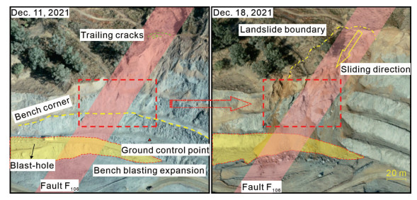
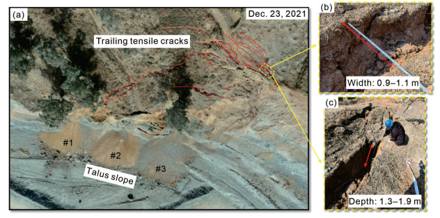
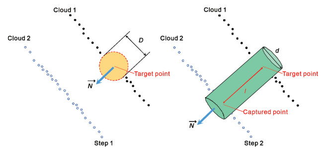
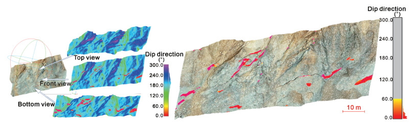
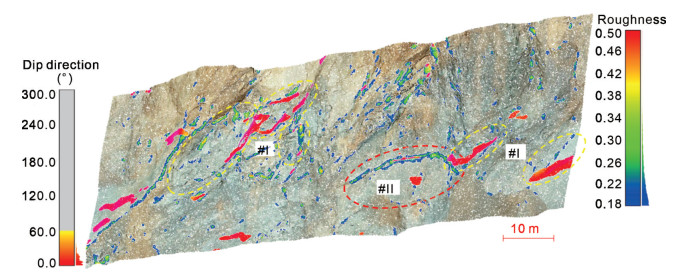
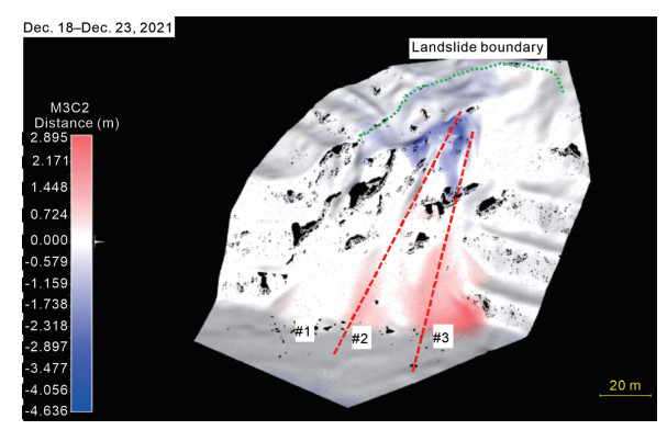
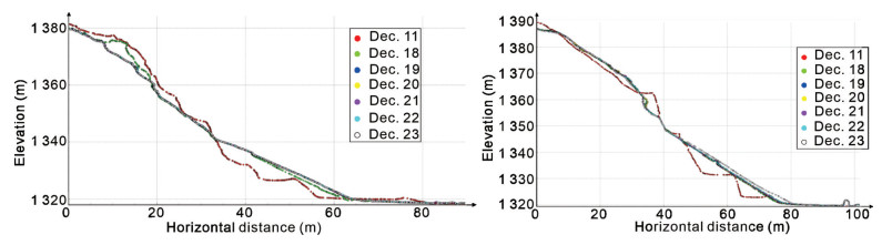
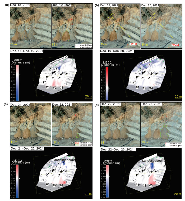
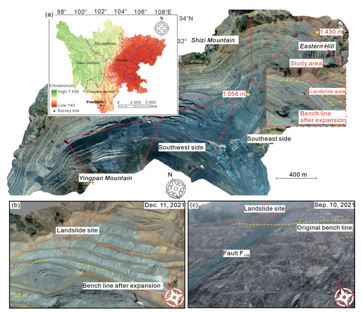
Source identification and deformation analysis of disaster bodies are the main contents of high-steep slope risk assessment, the establishment of high-precision model and the quantification of the fine geometric features of the slope are the prerequisites for the above work. In this study, based on the UAV remote sensing technology in acquiring refined model and quantitative parameters, a semi-automatic dangerous rock identification method based on multi-source data is proposed. In terms of the periodicity UAV-based deformation monitoring, the monitoring accuracy is defined according to the relative accuracy of multi-temporal point cloud. Taking a high-steep slope as research object, the UAV equipped with special sensors was used to obtain multi-source and multi-temporal data, including high-precision DOM and multi-temporal 3D point clouds. The geometric features of the outcrop were extracted and superimposed with DOM images to carry out semi-automatic identification of dangerous rock mass, realizes the closed-loop of identification and accuracy verification; changing detection of multi-temporal 3D point clouds was conducted to capture deformation of slope with centimeter accuracy. The results show that the multi-source data-based semi-automatic dangerous rock identification method can complement each other to improve the efficiency and accuracy of identification, and the UAV-based multi-temporal monitoring can reveal the near real-time deformation state of slopes.

| Albarelli, D. S. N. A., Mavrouli, O. C., Nyktas, P., 2021. Identification of Potential Rockfall Sources Using UAV-Derived Point Cloud. Bulletin of Engineering Geology and the Environment, 80(8): 6539–6561. https://doi.org/10.1007/s10064-021-02306-2 |
| Al-Rawabdeh, A., He, F. N., Moussa, A., et al., 2016. Using an Unmanned Aerial Vehicle-Based Digital Imaging System to Derive a 3D Point Cloud for Landslide Scarp Recognition. Remote Sensing, 8(2): 95. https://doi.org/10.3390/rs8020095 |
| Balek, J., Blahůt, J., 2017. A Critical Evaluation of the Use of an Inexpensive Camera Mounted on a Recreational Unmanned Aerial Vehicle as a Tool for Landslide Research. Landslides, 14(3): 1217–1224. https://doi.org/10.1007/s10346-016-0782-7 |
| Çevik, E., Topal, T., 2003. GIS-Based Landslide Susceptibility Mapping for a Problematic Segment of the Natural Gas Pipeline, Hendek (Turkey). Environmental Geology, 44(8): 949–962. https://doi.org/10.1007/s00254-003-0838-6 |
| Chen, H. K., Tang, H. M., Liu, G. H., et al., 2004. Researches on Calculation Method of Support and Support-Anchorage Union to Unstable Rock. Chinese Journal of Geotechnical Engineering, 26(3): 383–388 (in Chinese with English Abstract) http://www.cnki.com.cn/Article/CJFDTotal-YTGC200403019.htm |
| Cheng, Z., Gong, W. P., Tang, H. M., et al., 2021. UAV Photogrammetry-Based Remote Sensing and Preliminary Assessment of the Behavior of a Landslide in Guizhou, China. Engineering Geology, 289: 106172. https://doi.org/10.1016/j.enggeo.2021.106172 |
| Colomina, I., Molina, P., 2014. Unmanned Aerial Systems for Photogrammetry and Remote Sensing: A Review. ISPRS Journal of Photogrammetry and Remote Sensing, 92: 79–97. https://doi.org/10.1016/j.isprsjprs.2014.02.013 |
| Cook, K. L., 2017. An Evaluation of the Effectiveness of Low-Cost UAVs and Structure from Motion for Geomorphic Change Detection. Geomorphology, 278: 195–208. https://doi.org/10.1016/j.geomorph.20 16.11.009 doi: 10.1016/j.geomorph.2016.11.009 |
| Du, W. J., Sheng, Q., Fu, X. D., et al., 2021. Extensions of the Two-Phase Double-Point Material Point Method to Simulate the Landslide-Induced Surge Process. Engineering Analysis with Boundary Elements, 133: 362–375. https://doi.org/10.1016/j.enganabound.2021.09.020 |
| Du, W. J., Sheng, Q., Fu, X. D., et al., 2022. A TPDP-MPM-Based Approach to Understanding the Evolution Mechanism of Landslide-Induced Disaster Chain. Journal of Rock Mechanics and Geotechnical Engineering, 14(4): 1200–1209 http://www.cnki.com.cn/Article/CJFDTotal-JRMG202204016.htm |
| Du, Y., Li, H., Chicas, S. D., et al., 2022. Progress and Perspectives of Geotechnical Anchor Bolts on Slope Engineering in China. Frontiers in Environmental Science, 10: 928064. https://doi.org/10.3389/fenvs.2022.928064 |
| Du, Y., Xie, M. W., 2022. Indirect Method for the Quantitative Identification of Unstable Rock. Natural Hazards, 112(1): 1005–1012. https://doi.org/10.1007/s11069-021-05197-4 |
|
EDF-R & D, Telecom Paris Tech, 2022. Cloud Compare Version 2.12, [GPL Software]. Retrieved from. |
| Esposito, G., Salvini, R., Matano, F., et al., 2017. Multitemporal Monitoring of a Coastal Landslide through SFM-Derived Point Cloud Comparison. The Photogrammetric Record, 32(160): 459–479. https://doi.org/10.1111/phor.12218 |
| Fanti, R., Gigli, G., Lombardi, L., et al., 2013. Terrestrial Laser Scanning for Rockfall Stability Analysis in the Cultural Heritage Site of Pitigliano (Italy). Landslides, 10(4): 409–420. https://doi.org/10.1007/s10346-012-0329-5 |
| Gantimurova, S., Parshin, A., Erofeev, V., 2021. GIS-Based Landslide Susceptibility Mapping of the Circum-Baikal Railway in Russia Using UAV Data. Remote Sensing, 13(18): 3629. https://doi.org/10.3390/rs13183629 |
| Giordan, D., Hayakawa, Y., Nex, F., et al., 2018. Review Article: The Use of Remotely Piloted Aircraft Systems (RPASs) for Natural Hazards Monitoring and Management. Natural Hazards and Earth System Sciences, 18(4): 1079–1096. https://doi.org/10.5194/nhess-18-1079-2018 |
| Godone, D., Allasia, P., Borrelli, L., et al., 2020. UAV and Structure from Motion Approach to Monitor the Maierato Landslide Evolution. Remote Sensing, 12(6): 1039. https://doi.org/10.3390/rs12061039 |
| Gojcic, Z., Schmid, L., Wieser, A., 2021. Dense 3D Displacement Vector Fields for Point Cloud-Based Landslide Monitoring. Landslides, 18(12): 3821–3832. https://doi.org/10.1007/s10346-021-01761-y |
|
Gonzalez, D., Patricio, M. A., Berlanga, A., et al., 2019. A Convolutional Neural Network Model for Superresolution Enhancement of UAV Images. 2019 IEEE International Conference on Pervasive Computing and Communications Workshops (PerCom Workshops). March 11–15, 2019, Kyoto, Japan. IEEE, 992–997. |
| Guo, J. T., Liu, Y. H., Wu, L. X., et al., 2019. A Geometry- and Texture-Based Automatic Discontinuity Trace Extraction Method for Rock Mass Point Cloud. International Journal of Rock Mechanics and Mining Sciences, 124: 104132. https://doi.org/10.1016/j.ijrmms.2019.104132 http://www.xueshufan.com/publication/2981528563 |
| Haugerud, R., Harding, D., 2001. Some Algorithms for Virtual Deforestation (Vdf) of Lidar Topographic Survey Data. Int. Arch. Photogramm. Remote. Sens. , XXXIV–3/W4: 211–217 http://www.lidar.com.br/arquivos/virtualdeforestation.pdf |
| Hungr, O., Leroueil, S., Picarelli, L., 2014. The Varnes Classification of Landslide Types, an Update. Landslides, 11(2): 167–194. https://doi.org/10.1007/s10346-013-0436-y |
| Jia, B. N., Wu, Z. X., Du, Y., 2019. Real-Time Stability Assessment of Unstable Rocks Based on Fundamental Natural Frequency. International Journal of Rock Mechanics and Mining Sciences, 124: 104134. https://doi.org/10.1016/j.ijrmms.2019.104134 |
| Kang, J. Y., Wan, D. C., Sheng, Q., et al., 2022. Risk Assessment and Support Design Optimization of a High Slope in an Open Pit Mine Using the Jointed Finite Element Method and Discontinuous Deformation Analysis. Bulletin of Engineering Geology and the Environment, 81(6): 254. https://doi.org/10.1007/s10064-022-02759-z |
| Lague, D., Brodu, N., Leroux, J., 2013. Accurate 3D Comparison of Complex Topography with Terrestrial Laser Scanner: Application to the Rangitikei Canyon (N-Z). ISPRS Journal of Photogrammetry and Remote Sensing, 82: 10–26. https://doi.org/10.1016/j.isprsjprs.2013.04.009 |
| Li, C. C., Zhang, G. S., Lei, T. J., et al., 2011. Quick Image-Processing Method of UAV without Control Points Data in Earthquake Disaster Area. Transactions of Nonferrous Metals Society of China, 21: 523–528. https://doi.org/10.1016/s1003-6326(12)61635-5 |
| Lindner, G., Schraml, K., Mansberger, R., et al., 2016. UAV Monitoring and Documentation of a Large Landslide. Applied Geomatics, 8(1): 1–11. https://doi.org/10.1007/s12518-015-0165-0 |
| McKean, J., Roering, J., 2004. Objective Landslide Detection and Surface Morphology Mapping Using High-Resolution Airborne Laser Altimetry. Geomorphology, 57(3/4): 331–351. https://doi.org/10.1016/s0169-555x(03)00164-8 |
| Meng, Q. K., Li, W. L., Raspini, F., et al., 2021. Time-Series Analysis of the Evolution of Large-Scale Loess Landslides Using InSAR and UAV Photogrammetry Techniques: A Case Study in Hongheyan, Gansu Province, Northwest China. Landslides, 18(1): 251–265. https://doi.org/10.1007/s10346-020-01490-8 |
| Peternel, T., Kumelj, Š., Oštir, K., et al., 2017. Monitoring the Potoška Planina Landslide (NW Slovenia) Using UAV Photogrammetry and Tachymetric Measurements. Landslides, 14(1): 395–406. https://doi.org/10.1007/s10346-016-0759-6 |
| Riquelme, A., Tomás, R., Cano, M., et al., 2018. Automatic Mapping of Discontinuity Persistence on Rock Masses Using 3D Point Clouds. Rock Mechanics and Rock Engineering, 51(10): 3005–3028. https://doi.org/10.1007/s00603-018-1519-9 |
| Rodriguez, J., Macciotta, R., Hendry, M. T., et al., 2020. UAVs for Monitoring, Investigation, and Mitigation Design of a Rock Slope with Multiple Failure Mechanisms—A Case Study. Landslides, 17(9): 2027–2040. https://doi.org/10.1007/s10346-020-01416-4 |
| Rossi, G., Tanteri, L., Tofani, V., et al., 2018. Multitemporal UAV Surveys for Landslide Mapping and Characterization. Landslides, 15(5): 1045–1052. https://doi.org/10.1007/s10346-018-0978-0 |
| Scaioni, M., Longoni, L., Melillo, V., et al., 2014. Remote Sensing for Landslide Investigations: An Overview of Recent Achievements and Perspectives. Remote Sensing, 6(10): 9600–9652. https://doi.org/10.3390/rs6109600 |
| Turner, D., Lucieer, A., de Jong, S., 2015. Time Series Analysis of Landslide Dynamics Using an Unmanned Aerial Vehicle (UAV). Remote Sensing, 7(2): 1736–1757. https://doi.org/10.3390/rs70201736 |
| Valkaniotis, S., Papathanassiou, G., Ganas, A., 2018. Mapping an Earthquake-Induced Landslide Based on UAV Imagery; Case Study of the 2015 Okeanos Landslide, Lefkada, Greece. Engineering Geology, 245: 141–152. https://doi.org/10.1016/j.enggeo.2018.08.010 |
| Westoby, M. J., Brasington, J., Glasser, N. F., et al., 2012. 'Structure-from-Motion' Photogrammetry: A Low-Cost, Effective Tool for Geoscience Applications. Geomorphology, 179: 300–314. https://doi.org/10.1016/j.geomorph.2012.08.021 |
| Xu, Q., Li, W. L., Ju, Y. Z., et al., 2020. Multitemporal UAV-Based Photogrammetry for Landslide Detection and Monitoring in a Large Area: A Case Study in the Heifangtai Terrace in the Loess Plateau of China. Journal of Mountain Science, 17(8): 1826–1839. https://doi.org/10.1007/s11629-020-6064-9 |
| Zamzam, S., 2023. Geological Controls and Prospectivity Mapping for Manganese Ore Deposits Using Predictive Modeling Comparison: An Integration of Outcrop and Remote Sensing Data, Sinai Microplate, Egypt. Journal of Earth Science, 34(2): 588–608. https://doi.org/10.1007/s12583-021-1583-z |
| Zhang, W. M., Qi, J. B., Wan, P., et al., 2016. An Easy-to-Use Airborne LiDAR Data Filtering Method Based on Cloth Simulation. Remote Sensing, 8(6): 501. https://doi.org/10.3390/rs8060501 |
| Zhang, Y. G., Tang, J., Cheng, Y., et al., 2022. Prediction of Landslide Displacement with Dynamic Features Using Intelligent Approaches. International Journal of Mining Science and Technology, 32(3): 539–549. https://doi.org/10.1016/j.ijmst.2022.02.004 |
| Zhao, B., Zhang, H. Q., Liao, H. J., et al., 2021. Emergency Response to the Reactivated Aniangzhai Landslide Resulting from a Rainstorm-Triggered Debris Flow, Sichuan Province, China. Landslides, 18(3): 1115–1130. https://doi.org/10.1007/s10346-020-01612-2 |
Figures(15) / Tables(3)
Copyright © 2013-2020 Journal of Earth Science 鄂ICP备15021562号-2
Tel: +86-27-67885075 Fax: +86-27-67885075 E-mail: xbb@cug.edu.cn
Address: Editorial Office of Journal, China University of Geosciences, Yujiashan, Wuhan, Hubei 430074, P. R. China
Supported by:
Beijing Renhe Information Technology Co. Ltd
E-mail:
info@rhhz.net


 DownLoad: