| Citation: | Yiqiu Yan, Changbao Guo, Yanan Zhang, Zhendong Qiu, Caihong Li, Xue Li. Development and Deformation Characteristics of Large Ancient Landslides in the Intensely Hazardous Xiongba-Sela Section of the Jinsha River, Eastern Tibetan Plateau, China. Journal of Earth Science, 2024, 35(3): 980-997. doi: 10.1007/s12583-023-1925-y

|
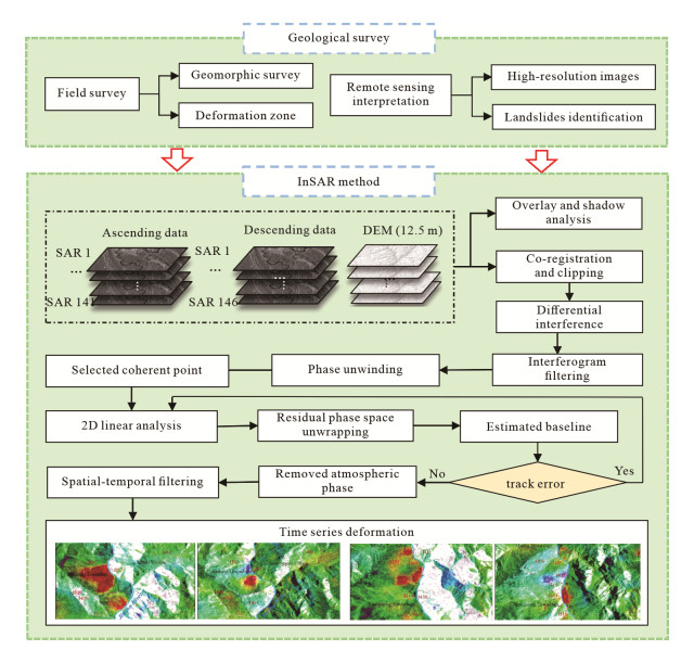
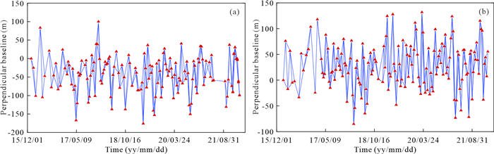
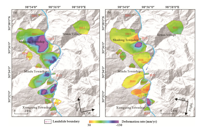
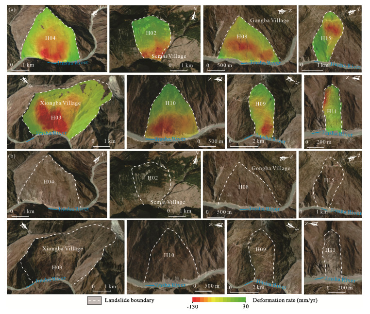
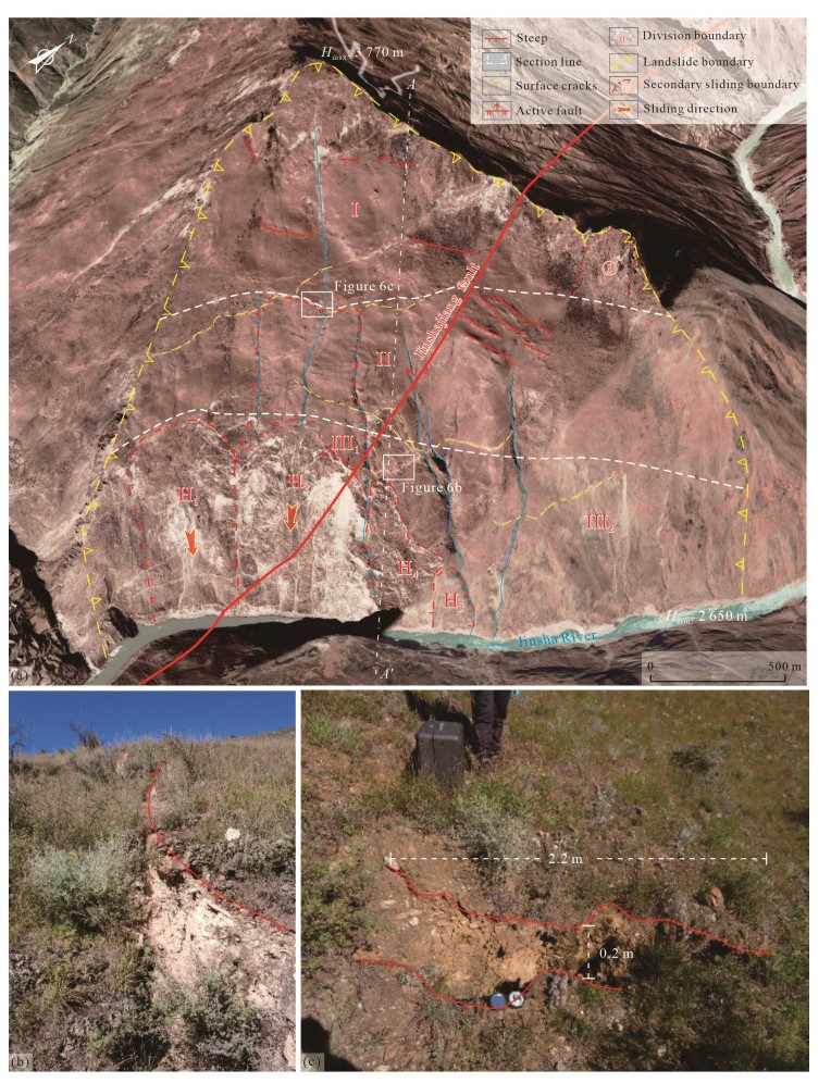
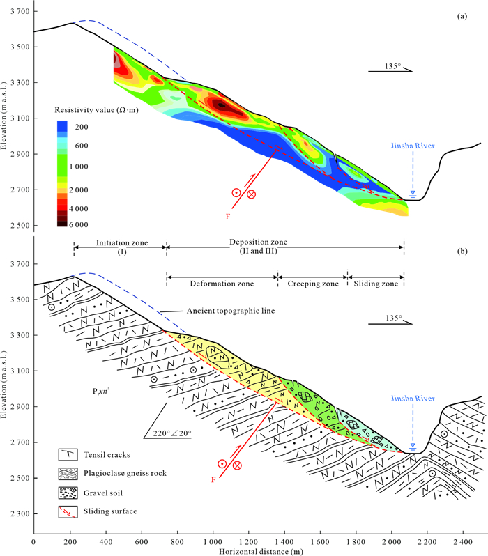
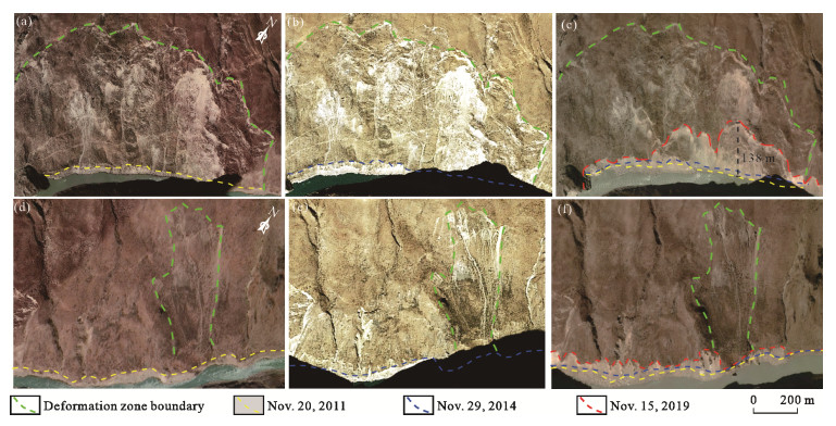
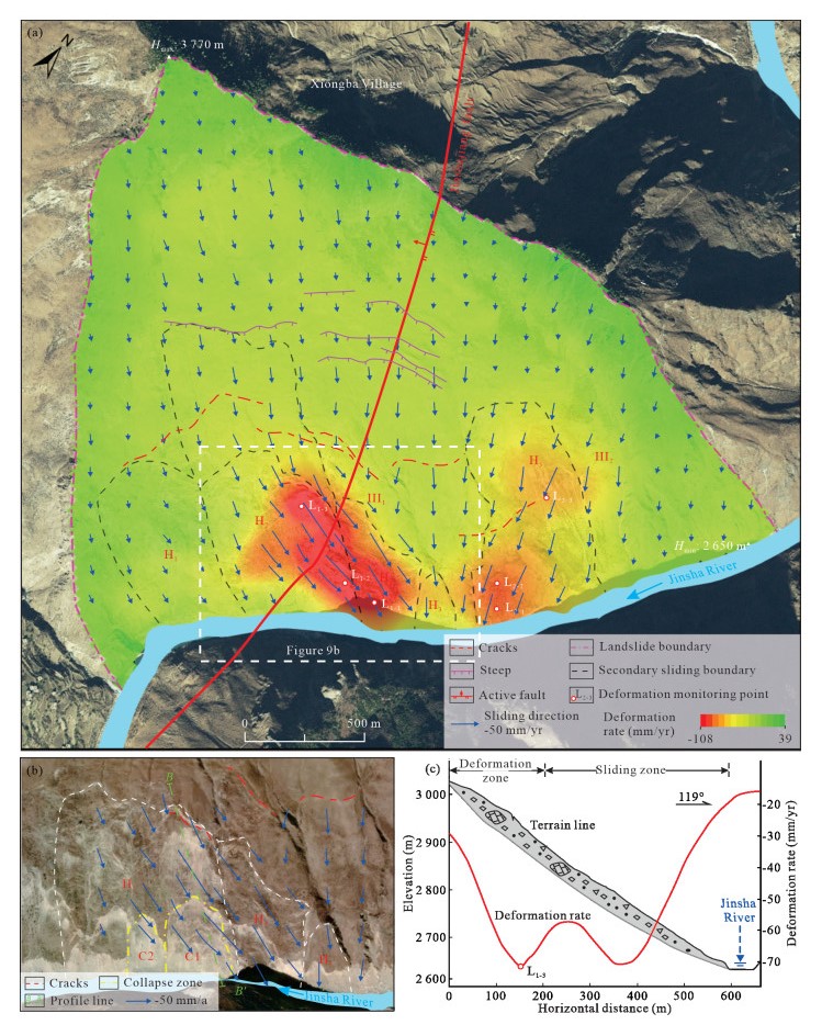
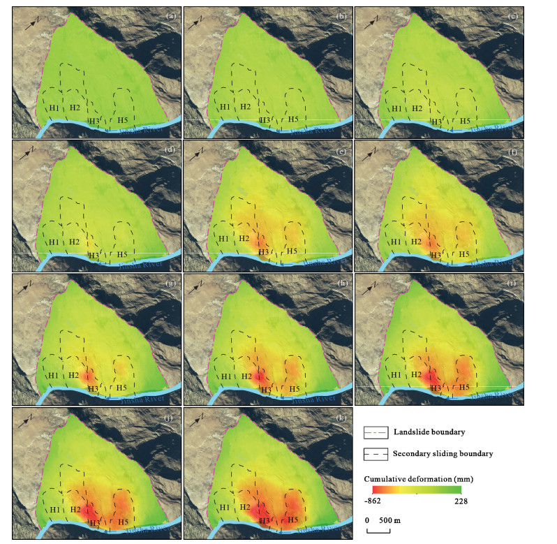
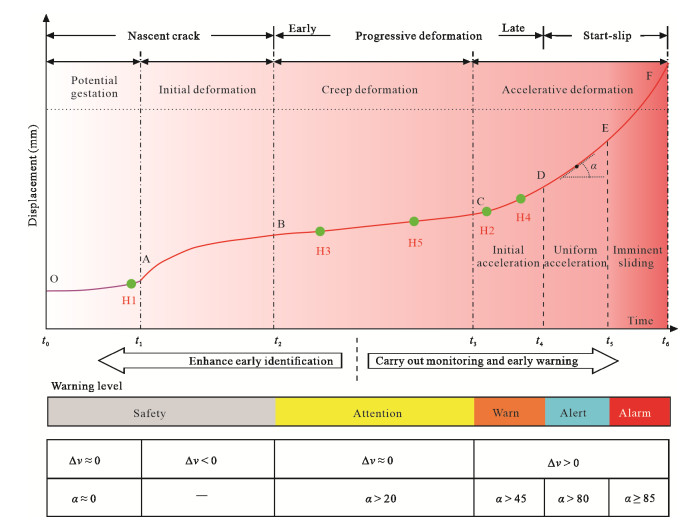
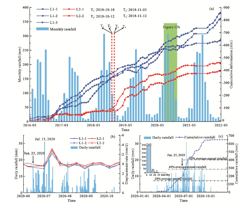
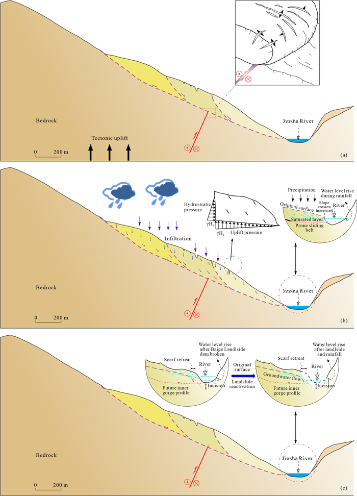
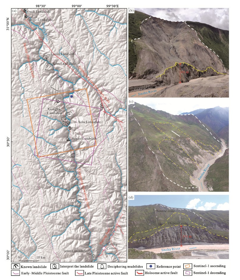
The upstream Jinsha River, located in the eastern Tibetan Plateau, has been experiencing intense geological hazards characterized by a high density of ancient landslides, significant deformation and reactivation challenges. In this study, remote sensing interpretation, field investigations, and Small Baseline Subset Interferometric Synthetic Aperture Radar (SBAS-InSAR) technologies have been employed. Along a 17 km stretch of the Jinsha River, specifically in the Xiongba-Sela segment, 16 large-scale ancient landslides were identified, 9 of which are currently undergoing creeping deformation. Notably, the Sela and Xiongba ancient landslides exhibit significant deformation, with a maximum deformation rate of -192 mm/yr, indicating a high level of sliding activity. The volume of the Sela ancient landslide is estimated to be 1.8 × 10⁸ to 4.5 × 10⁸ m3, and characterized by extensive fissures and long-term creeping deformation. The SBAS-InSAR results revealed significant spatial variations in the deformation of the Sela ancient landslide, generally displaying two secondary zones of intense deformation, and landslide deformation exhibits nonlinear behavior with time. Between January 2016 and February 2022, Zone Ⅲ1 on the southwest side of the Sela ancient landslide, experienced a maximum cumulative deformation of -857 mm, with a maximum deformation rate of -108 mm/yr. Zone Ⅲ2, on the northeast side of the Sela ancient landslide, the maximum cumulative deformation was -456 mm, with a maximum deformation rate of -74 mm/yr; among these, the H2 and H4 secondary bodies on the south side of Ⅲ1 are in the accelerative deformation stage and at the Warn warning level. We propose that the large-scale flood and debris flow disasters triggered by the Baige landslide-dammed lake-dam broken disaster chain in Tibetan Plateau during October and November 2018 caused severe erosion at the foot of downstream slopes. This far-field triggering effect accelerated the creep of the downstream ancient landslides. Consequently, the deformation rate of Zone Ⅲ2 of the Sela ancient landslide increased by 6 to 8 times, exhibiting traction-type style reactivation. This heightened activity raises concerns about the potential for large-scale or overall reactivation of the landslide, posing a risk of damming the Jinsha River and initiating a dam-break disaster chain. Our research on the reactivation characteristics and mechanisms of large ancient landslides in high deep-cut valleys provides valuable guidance for geological hazard investigation and risk prevention.

| Bao, Y. D., Zhai, S. J., Chen, J. P., et al., 2020. The Evolution of the Samaoding Paleolandslide River Blocking Event at the Upstream Reaches of the Jinsha River, Tibetan Plateau. Geomorphology, 351: 106970. https://doi.org/10.1016/j.geomorph.2019.106970 |
| Berardino, P., Fornaro, G., Lanari, R., et al., 2002. A New Algorithm for Surface Deformation Monitoring Based on Small Baseline Differential SAR Interferograms. IEEE Transactions on Geoscience and Remote Sensing, 40(11): 2375–2383. https://doi.org/10.1109/tgrs.2002.803792 |
| Brideau, M. A., Pedrazzini, A., Stead, D., et al., 2011. Three-Dimensional Slope Stability Analysis of South Peak, Crowsnest Pass, Alberta, Canada. Landslides, 8(2): 139–158. https://doi.org/10.1007/s10346-010-0242-8 |
| Dai, C., Li, W. L., Wang, D., et al., 2021. Active Landslide Detection Based on Sentinel-1 Data and InSAR Technology in Zhouqu County, Gansu Province, Northwest China. Journal of Earth Science, 32(5): 1092–1103. https://doi.org/10.1007/s12583-020-1380-0 |
| Debella-Gilo, M., Kääb, A., 2011. Sub-Pixel Precision Image Matching for Measuring Surface Displacements on Mass Movements Using Norma-lized Cross-Correlation. Remote Sensing of Environment, 115(1): 130–142. https://doi.org/10.1016/j.rse.2010.08.012 |
| Delaney, K. B., Evans, S. G., 2015. The 2000 Yigong Landslide (Tibetan Plateau), Rockslide-Dammed Lake and Outburst Flood: Review, Remote Sensing Analysis, and Process Modelling. Geomorphology, 246: 377–393. https://doi.org/10.1016/j.geomorph.2015.06.020 |
| Dong, S. C., Samsonov, S., Yin, H. W., et al., 2018. Two-Dimensional Ground Deformation Monitoring in Shanghai Based on SBAS and MSBAS InSAR Methods. Journal of Earth Science, 29(4): 960–968. https://doi.org/10.1007/s12583-017-0955-x |
| Fan, X. M., Yang, F., Siva Subramanian, S., et al., 2020. Prediction of a Multi-Hazard Chain by an Integrated Numerical Simulation Approach: The Baige Landslide, Jinsha River, China. Landslides, 17(1): 147–164. https://doi.org/10.1007/s10346-019-01313-5 |
| Gao, H. Y., Gao, Y., Yin, Y. P., et al., 2022. New Scientific Issues in the Study of High-Elevation and Long-Runout Landslide Dynamics in the Qinghai-Tibet Plateau. Journal of Geomechanics, 28(6): 1090–1103. https://doi.org/10.12090/j.issn.1006-6616.20222831 (in Chinese with English Abstract) |
| Govi, M., Sorzana, P., Tropeano, D., 1982. Landslide Mapping as Evidence of Extreme Regional Events. Studia Geomorphol Carpatho-Balcanica, 15: 81–98 |
| Guo, C. B., Yan, Y. Q., Zhang, Y. S., et al., 2021. Study on the Creep-Sliding Mechanism of the Giant Xiongba Ancient Landslide Based on the SBAS-InSAR Method, Tibetan Plateau, China. Remote Sensing, 13(17): 3365. https://doi.org/10.3390/rs13173365 |
| Guo, C. B., Yan, Y. Q., Zhang, Y. S., et al., 2022. Research Progress and Prospect of Failure Mechanism of Large Deep-Seated Creeping Landslides in Tibetan Plateau, China. Earth Science, 47(10): 3677–3700. https://doi.org/10.3799/dqkx.2022.249 (in Chinese with English Abstract) |
| Guo, C. B., Zhang, Y. S., Li, X., et al., 2020. Reactivation of Giant Jiangdingya Ancient Landslide in Zhouqu County, Gansu Province, China. Landslides, 17(1): 179–190. https://doi.org/10.1007/s10346-019-01266-9 |
| Guo, C., Xu, Q., Dong, X. J., et al., 2021. Geohazard Recognition and Inventory Mapping Using Airborne LiDAR Data in Complex Moun-tainous Areas. Journal of Earth Science, 32(5): 1079–1091. https://doi.org/10.1007/s12583-021-1467-2 |
| Guo, J., Xu, M., Zhang, Q., et al., 2020. Reservoir Regulation for Control of an Ancient Landslide Reactivated by Water Level Fluctuations in Heishui River, China. Journal of Earth Science, 31(6): 1058–1067. https://doi.org/10.1007/s12583-020-1341-7 |
| Herrera, G., Gutiérrez, F., García-Davalillo, J. C., et al., 2013. Multi-Sensor Advanced DInSAR Monitoring of very Slow Landslides: The Tena Valley Case Study (Central Spanish Pyrenees). Remote Sensing of Environment, 128: 31–43. https://doi.org/10.1016/j.rse.2012.09.020 |
| Hooper, A., Segall, P., Zebker, H., 2007. Persistent Scatterer Interferometric Synthetic Aperture Radar for Crustal Deformation Analysis, with Application to Volcán Alcedo, Galápagos. Journal of Geophysical Research: Solid Earth, 112(B7): B07407. https://doi.org/10.1029/2006jb004763 |
| Iqbal, J., Dai, F. C., Hong, M., et al., 2018. Failure Mechanism and Stability Analysis of an Active Landslide in the Xiangjiaba Reservoir Area, Southwest China. Journal of Earth Science, 29(3): 646–661. https://doi.org/10.1007/s12583-017-0753-5 |
| Kim, J. W., Lu, Z., Degrandpre, K., 2016. Ongoing Deformation of Sinkholes in Wink, Texas, Observed by Time-Series Sentinel-1A SAR Interferometry (Preliminary Results). Remote Sensing, 8(4): 313. https://doi.org/10.3390/rs8040313 |
| Lanari, R., Casu, F., Manzo, M., et al., 2007. An Overview of the Small BAseline Subset Algorithm: A DInSAR Technique for Surface Deformation Analysis. Pure and Applied Geophysics, 164(4): 637–661. https://doi.org/10.1007/s00024-007-0192-9 |
| Li, X., Guo, C. B., Yang, Z. H., et al., 2021. Development Characteristics and Formation Mechanism of the Xiongba Giant Ancient Landslide in the Jinshajiang Tectonic Zone. Geoscience, 35(1): 47–55. https://doi.org/10.19657/j.geoscience.1000-8527.2020.095 (in Chinese with English Abstract) |
| Li, Y. C., Chen, J. P., Zhou, F. J., et al., 2020. Identification of Ancient River-Blocking Events and Analysis of the Mechanisms for the Formation of Landslide Dams in the Suwalong Section of the Upper Jinsha River, SE Tibetan Plateau. Geomorphology, 368: 107351. https://doi.org/10.1016/j.geomorph.2020.107351 |
| Liang, L. J., Zhang, Z. R., Dai, F. C., 2022. A Late Pleistocene Landslide Damming Event and Its Implications for the Evolution of River Valley Landforms in the Upper Jinsha River, Southeastern Tibetan Plateau. Quaternary International, 622: 97–109. https://doi.org/10.1016/j.quaint.2022.01.006 |
| Liu, X. J., Zhao, C. Y., Zhang, Q., et al., 2021. Three-Dimensional and Long-Term Landslide Displacement Estimation by Fusing C- and L-Band SAR Observations: A Case Study in Gongjue County, Tibet, China. Remote Sensing of Environment, 267: 112745. https://doi.org/10.1016/j.rse.2021.112745 |
| Lu, H. Y., Li, W. L., Xu, Q., et al., 2019. Early Detection of Landslides in the Upstream and Downstream Areas of the Baige Landslide, the Jinsha River Based on Optical Remote Sensing and InSAR Technologies. Geomatics and Information Science of Wuhan University, 44(9): 1342–1354. https://doi.org/10.13203/j.whugis20190086 (in Chinese with English Abstract) |
| Usai, S., 2003. A Least Squares Database Approach for SAR Interferometric Data. IEEE Transactions on Geoscience and Remote Sensing, 41(4): 753–760. https://doi.org/10.1109/tgrs.2003.810675 |
| Wasowski, J., Bovenga, F., 2014. Investigating Landslides and Unstable Slopes with Satellite Multi Temporal Interferometry: Current Issues and Future Perspectives. Engineering Geology, 174: 103–138. https://doi.org/10.1016/j.enggeo.2014.03.003 |
| Wu, R. A., Guo, C. B., Ni, J. W., et al., 2023. Ancient Landslide River Damming Event in the Batang Fault Zone, Tibetan Plateau. Bulletin of Engineering Geology and the Environment, 82(1): 25. https://doi.org/10.1007/s10064-022-03048-5 |
| Xie, M. L., Zhao, W. H., Ju, N. P., et al., 2020. Landslide Evolution Assessment Based on InSAR and Real-Time Monitoring of a Large Reactivated Landslide, Wenchuan, China. Engineering Geology, 277: 105781. https://doi.org/10.1016/j.enggeo.2020.105781 |
| Xu, Q., Yuan, Y., Zeng, Y. P., et al., 2011. Some New Pre-Warning Criteria for Creep Slope Failure. Science China Technological Sciences, 54(1): 210–220. https://doi.org/10.1007/s11431-011-4640-5 |
| Xu, Q., Zheng, G., Li, W. L., et al., 2018. Study on Successive Landslide Damming Events of Jinsha River in Baige Village on Octorber 11 and November 3, 2018. Journal of Engineering Geology, 26(6): 1534–1551. https://doi.org/10.13544/j.cnki.jeg.2018-406 (in Chinese with English Abstract) |
| Yan, Y. Q., Guo, C. B., Zhong, N., 2022. Deformation Characteristics of Jiaju Ancient Landslide Based on InSAR Monitoring Method, Sichuan, China. Earth Science, 47(12): 4681–4697. https://doi.org/10.3799/dqkx.2022.162 (in Chinese with English Abstract) |
| Yang, Y. T., Liu, M., Quincey, D. J., et al., 2023. Cyclic Landslide-Flood Chains along a Major Mountain River. Geomorphology, 439: 108835. https://doi.org/10.1016/j.geomorph.2023.108835 |
| Yao, J. M., Yao, X., Liu, X. H., 2022. Landslide Detection and Mapping Based on SBAS-InSAR and PS-InSAR: A Case Study in Gongjue County, Tibet, China. Remote Sensing, 14(19): 4728. https://doi.org/10.3390/rs14194728 |
| Zhang, C. Y., Yin, Y. P., Dai, Z. W., et al., 2021. Reactivation Mechanism of a Large-Scale Ancient Landslide. Landslides, 18(1): 397–407. https://doi.org/10.1007/s10346-020-01538-9 |
| Zhang, L. M., Xiao, T., He, J., et al., 2019. Erosion-Based Analysis of Breaching of Baige Landslide Dams on the Jinsha River, China, in 2018. Landslides, 16(10): 1965–1979. https://doi.org/10.1007/s10346-019-01247-y |
| Zhang, S. L., Yin, Y. P., Hu, X. W., et al., 2020. Dynamics and Emplacement Mechanisms of the Successive Baige Landslides on the Upper Reaches of the Jinsha River, China. Engineering Geology, 278: 105819. https://doi.org/10.1016/j.enggeo.2020.105819 |
| Zhong, Q. M., Chen, S. S., Wang, L., et al., 2020. Back Analysis of Breaching Process of Baige Landslide Dam. Landslides, 17(7): 1681–1692. https://doi.org/10.1007/s10346-020-01398-3 |
| Zhou, M. D., Lü, T. Y., Zhang, Y. S., et al., 2000. The Geological Structure Background and the Crustal Structure in the Northeastern Margin of the Qinghai-Tibetan Plateau. Acta Seismologica Sinica, 13(6): 687–697. https://doi.org/10.1007/s11589-000-0071-2 |
| Zhu, S. N., Yin, Y. P., Wang, M., et al., 2021. Instability Mechanism and Disaster Mitigation Measures of Long-distance Landslide at High Location in Jinsha River Junction Zone: Case Study of the Sela Landslide in Jinsha River, Tibet. Chinese Journal of Geotechnical Engineering, 43(4): 688–697. https://doi.org/10.11779/cjge202104011 (in Chinese with English Abstract) |
Figures(13) / Tables(3)
Copyright © 2013-2020 Journal of Earth Science 鄂ICP备15021562号-2
Tel: +86-27-67885075 Fax: +86-27-67885075 E-mail: xbb@cug.edu.cn
Address: Editorial Office of Journal, China University of Geosciences, Yujiashan, Wuhan, Hubei 430074, P. R. China
Supported by:
Beijing Renhe Information Technology Co. Ltd
E-mail:
info@rhhz.net


 DownLoad: