| Citation: | Xuyang Xiang, Wenping Gong, Fumeng Zhao, Zhan Cheng, Lei Wang. Earthquake-Induced Landslide Mapping in Mountainous Areas Using a Semantic Segmentation Model Combined with a Dual Feature Pyramid. Journal of Earth Science, 2026, 37(2): 685-702. doi: 10.1007/s12583-023-1956-6

|
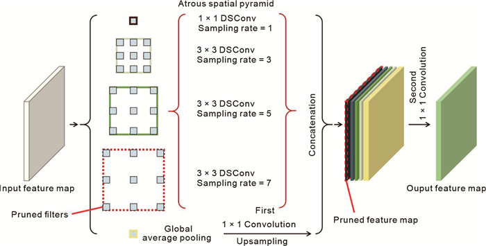
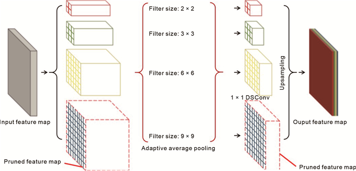
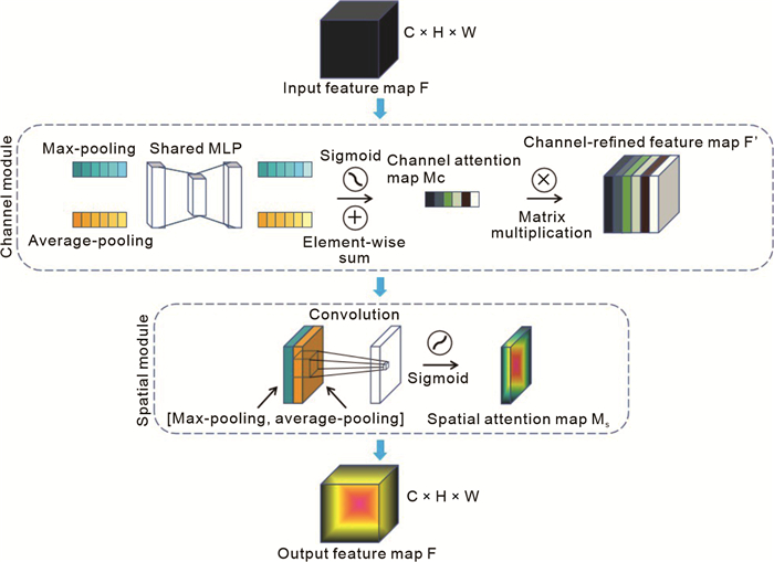
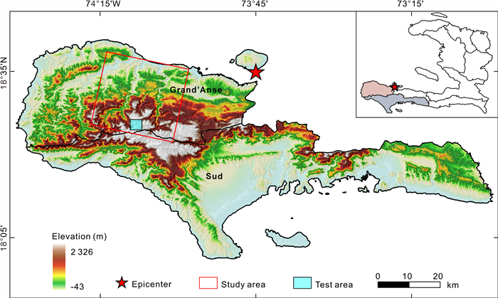
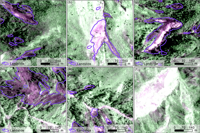
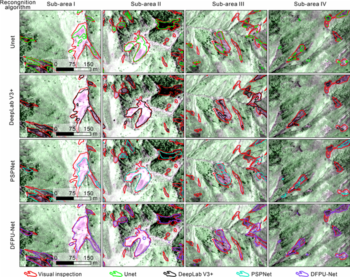
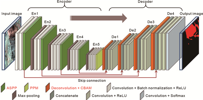
Landslides are widely distributed in mountainous regions around the world. Rapid mapping of earthquake-induced landslides in mountainous areas plays a crucial role in post-disaster assessment and rescue planning. In mountainous areas, it is challenging to identify small landslides using existing landslide mapping methods accurately. To address this challenge, this paper proposes a dual feature pyramid-based UNet (DFPU-Net) model, which utilizes the VGG16 model as the backbone feature extraction network. Meanwhile, two modified pyramid-structured modules, in terms of the atrous spatial pyramid pooling (ASPP) module and pyramid pooling module (PPM), are integrated into the backbone feature extraction network. Furthermore, the features of landslides extracted by the enhanced feature extraction network are screened by the deconvolution layers and convolutional block attention module (CBAM). To demonstrate the effectiveness of the proposed model, landslides in Grand'Anse and Sud departments, induced by the 2021 Haiti

| Anshori, R. M., Samodra, G., Mardiatno, D., et al., 2022. Volunteered Geographic Information Mobile Application for Participatory Landslide Inventory Mapping. Computers & Geosciences, 161: 105073. https://doi.org/10.1016/j.cageo.2022.105073 |
| Bekaert, D. P. S., Handwerger, A. L., Agram, P., et al., 2020. InSAR-Based Detection Method for Mapping and Monitoring Slow-Moving Landslides in Remote Regions with Steep and Mountainous Terrain: An Application to Nepal. Remote Sensing of Environment, 249: 111983. https://doi.org/10.1016/j.rse.202 0.111983 doi: 10.1016/j.rse.2020.111983 |
| Berrar, D., 2019. Cross-Validation. Encyclopedia of Bioinformatics and Computational Biology, Academic Press, Oxford, 542–545 |
| Borghuis, A. M., Chang, K., Lee, H. Y., 2007. Comparison between Automated and Manual Mapping of Typhoon‐Triggered Landsli-des from SPOT‐5 Imagery. International Journal of Remote Sensing, 28(8): 1843–1856. https://doi.org/10.1080/01431160600935638 |
| Chen, L. C., Zhu, Y. K., Papandreou, G., et al., 2018. Encoder-Decoder with Atrous Separable Convolution for Semantic Image Segmentation. Computer Vision–ECCV 2018. Springer, Cham |
| Cheng, Z., Gong, W. P., Tang, H. M., et al., 2021. UAV Photogrammetry-Based Remote Sensing and Preliminary Assessment of the Behavior of a Landslide in Guizhou, China. Engineering Geology, 289: 106172. https://doi.org/10.1016/j.eng geo.2021.106172 doi: 10.1016/j.enggeo.2021.106172 |
|
Chollet, F., 2017. Xception: Deep Learning with Depthwise Separable Convolutions. 2017 IEEE Conference on Computer Vision and Pattern Recognition (CVPR). July 21–26, 2017, Honolulu, HI, USA. IEEE: 1800–1807. |
| Cui, S., Ma, A. L., Zhang, L. P., et al., 2021. MAP-Net: SAR and Optical Image Matching via Image-Based Convolutional Network with Attention Mechanism and Spatial Pyramid Aggregated Pooling. IEEE Transactions on Geoscience and Remote Sensing, 60: 1000513. https://doi.org/10.1109/tgrs.2021.3066432 |
| Du, B. W., Zhao, Z. R., Hu, X., et al., 2021. Landslide Susceptibility Prediction Based on Image Semantic Segmentation. Computers & Geosciences, 155: 104860. https://doi.org/10.1016/j.cageo.2021.104860 |
| Esgario, J. G. M., de Castro, P. B. C., Tassis, L. M., et al., 2022. An App to Assist Farmers in the Identification of Diseases and Pests of Coffee Leaves Using Deep Learning. Information Processing in Agriculture, 9(1): 38–47. https://doi.org/10.1016/j.inpa.2021.01.004 |
| Fan, X. Y., Tang, J. J., Tian, S. J., et al., 2020. Rainfall-Induced Rapid and Long-Runout Catastrophic Landslide on July 23, 2019 in Shuicheng, Guizhou, China. Landslides, 17(9): 2161–2171. https://doi.org/10.1007/s10346-020-01454-y |
| Fang, Z. C., Wang, Y., Peng, L., et al., 2020. Integration of Convolutional Neural Network and Conventional Machine Learning Classifiers for Landslide Susceptibility Mapping. Computers & Geosciences, 139: 104470. https://doi.org/10.1016/j.cageo.2020.104470 |
| Fanos, A. M., Pradhan, B., Mansor, S., et al., 2018. A Hybrid Model Using Machine Learning Methods and GIS for Potential Rockfall Source Identification from Airborne Laser Scanning Data. Landslides, 15(9): 1833–1850. https://doi.org/10.1007/s10346-018-0990-4 |
| Feng, P. F., Li, C. D., Zhang, S., et al., 2024. Integrating Shipborne Images with Multichannel Deep Learning for Landslide Detection. Journal of Earth Science, 35(1): 296–300. https://doi.org/10.1007/s12583-023-1957-5 |
| Gao, D. X., Li, K., Cai, Y. C., et al., 2024. Landslide Displacement Prediction Based on Time Series and PSO-BP Model in Three Georges Reservoir, China. Journal of Earth Science, 35(3): 1079–1082. https://doi.org/10.1007/s12583-021-1575-z |
| Gong, W. P., Juang, C. H., Wasowski, J., 2021. Geohazards and Human Settlements: Lessons Learned from Multiple Relocation Events in Badong, China–Engineering Geologist's Perspective. Engineering Geology, 285: 106051. https://doi.org/10.1016/j.enggeo.2021.106051 |
| Guzzetti, F., Mondini, A. C., Cardinali, M., et al., 2012. Landslide Inventory Maps: New Tools for an Old Problem. Earth-Science Reviews, 112(1/2): 42–66. https://doi.org/10.1016/j.earscirev.2012.02.001 |
| He, X., Zhou, Y., Zhao, J. Q., et al., 2022. Swin Transformer Embedding UNet for Remote Sensing Image Semantic Segmentation. IEEE Transactions on Geoscience and Remote Sensing, 60: 4408715. https://doi.org/10.1109/tgrs.2022.3144165 |
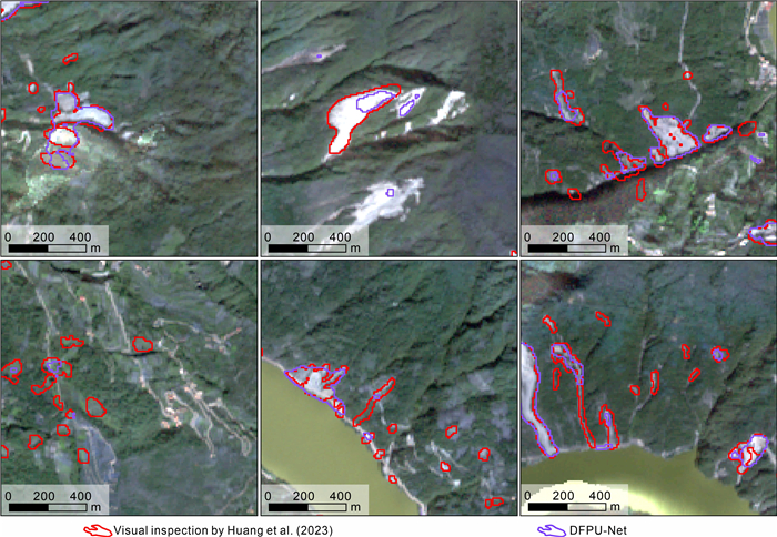
| Huang, Y. D., Xie, C. C., Li, T., et al., 2023. An Open-Accessed Inventory of Landslides Triggered by the M S6.8 Luding Earthquake, China on September 5, 2022. Earthquake Research Advances, 3(1): 100181. https://doi.org/10.1016/j.eqrea.2022.100181 |
| Jebur, M. N., Pradhan, B., Tehrany, M. S., 2015. Manifestation of LiDAR-Derived Parameters in the Spatial Prediction of Landslides Using Novel Ensemble Evidential Belief Functions and Support Vector Machine Models in GIS. IEEE Journal of Selected Topics in Applied Earth Observations and Remote Sensing, 8(2): 674–690. https://doi.org/10.1109/jstars.2014.2341276 |
| Ji, S. P., Yu, D. W., Shen, C. Y., et al., 2020. Landslide Detection from an Open Satellite Imagery and Digital Elevation Model Dataset Using Attention Boosted Convolutional Neural Networks. Landslides, 17(6): 1337–1352. https://doi.org/10.1007/s10346-020-01353-2 |
| John, D., Zhang, C., 2022. An Attention-Based U-Net for Detecting Deforestation within Satellite Sensor Imagery. International Journal of Applied Earth Observation and Geoinformation, 107: 102685. https://doi.org/10.1016/j.jag.2022.102685 |
| Li, H. J., He, Y. S., Xu, Q., et al., 2022. Detection and Segmentation of Loess Landslides via Satellite Images: A Two-Phase Framework. Landslides, 19(3): 673–686. https://doi.org/10.1007/s10346-021-01789-0 |
| Liang, T. L., Glossner, J., Wang, L., et al., 2021. Pruning and Quantization for Deep Neural Network Acceleration: A Survey. Neurocomputing, 461: 370–403. https://doi.org/10.1016/j.neuco m.2021.07.045 doi: 10.1016/j.neucom.2021.07.045 |
| Long, Y. J., Li, W. L., Huang, R. Q., et al., 2023. A Comparative Study of Supervised Classification Methods for Investigating Landslide Evolution in the Mianyuan River Basin, China. Journal of Earth Science, 34(2): 316–329. https://doi.org/10.1007/s12583-021-1525-9 |
| Lu, P., Shi, W. Y., Li, Z. B., 2021. Landslide Mapping from Planet Scope Images Using Improved Region-Based Level Set Evolution. IEEE Geoscience and Remote Sensing Letters, 19: 2502505. https://doi.org/10.1109/lgrs.2021.3122964 |
| Lu, P., Stumpf, A., Kerle, N., et al., 2011. Object-Oriented Change Detection for Landslide Rapid Mapping. IEEE Geoscience and Remote Sensing Letters, 8(4): 701–705. https://doi.org/10.1109/lgrs.2010.2101045 |
| Lundine, M. A., Brothers, L. L., Trembanis, A. C., 2023. Deep Learning for Pockmark Detection: Implications for Quantitative Seafloor Characterization. Geomorphology, 421: 108524. https://doi.org/10.1016/j.geomorph.2022.108524 |
| Lyu, Z. Y., Wang, F. J., Sun, W. W., et al., 2022. Landslide Inventory Mapping on VHR Images via Adaptive Region Shape Similarity. IEEE Transactions on Geoscience and Remote Sensing, 60: 5630211. https://doi.org/10.1109/tgrs.2022.3204834 |
| Middleton, M., Heikkonen, J., Nevalainen, P., et al., 2020. Machine Learning-Based Mapping of Micro-Topographic Earthquake-Induced Paleo-Pulju Moraines and Liquefaction Spreads from a Digital Elevation Model Acquired through Laser Scanning. Geomorphology, 358: 107099. https://doi.org/10.1016/j.geomorph.2020.107099 |
| Mondini, A. C., Guzzetti, F., Reichenbach, P., et al., 2011. Semi-Automatic Recognition and Mapping of Rainfall Induced Shallow Landslides Using Optical Satellite Images. Remote Sensing of Environment, 115(7): 1743–1757. https://doi.org/10.1016/j.rse.2011.03.006 |
| Morales, B., Lizama, E., Somos-Valenzuela, M., et al., 2023. Earthquake-Induced Landslides Coupled to Fluvial Incision in Andean Patagonia: Inferring Their Effects on Landscape at Geological Time Scales. Geomorphology, 434: 108731. https://doi.org/10.1016/j.geomorph.2023.108731 |
| Muthu, K., Petrou, M., 2007. Landslide-Hazard Mapping Using an Expert System and a GIS. IEEE Transactions on Geoscience and Remote Sensing, 45(2): 522–531. https://doi.org/10.1109/tgrs.2006.885404 |
| Muthu, K., Petrou, M., Tarantino, C., et al., 2008. Landslide Possibility Mapping Using Fuzzy Approaches. IEEE Transactions on Geoscience and Remote Sensing, 46(4): 1253–1265. https://doi.org/10.1109/tgrs.2007.912441 |
| Noh, H., Hong, S., Han, B., 2015. Learning Deconvolution Network for Semantic Segmentation. 2015 IEEE International Conference on Computer Vision (ICCV). December 7–13, 2015, Santiago. https://doi.org/10.1109/icc v.2015.178 |
| Paoletti, M. E., Haut, J. M., Plaza, J., et al., 2018. A New Deep Convolutional Neural Network for Fast Hyperspectral Image Classification. ISPRS Journal of Photogrammetry and Remote Sensing, 145: 120–147. https://doi.org/10.1016/j.isprsjprs.2017. 11.021 doi: 10.1016/j.isprsjprs.2017.11.021 |
| Pareek, N., Pal, S., Sharma, M. L., et al., 2013. Study of Effect of Seismic Displacements on Landslide Susceptibility Zonation (LSZ) in Garhwal Himalayan Region of India Using GIS and Remote Sensing Techniques. Computers & Geosciences, 61: 50–63. https://doi.org/10.1016/j.cageo.2013.07.018 |
| Prakash, N., Manconi, A., Loew, S., 2020. Mapping Landslides on EO Data: Performance of Deep Learning Models vs. Traditional Machine Learning Models. Remote Sensing, 12(3): 346. https://doi.org/10.3390/rs12030346 |
| Rau, J. Y., Jhan, J. P., Rau, R. J., 2014. Semiautomatic Object-Oriented Landslide Recognition Scheme from Multisensor Optical Imagery and DEM. IEEE Transactions on Geoscience and Remote Sensing, 52(2): 1336–1349. https://doi.org/10.1109/tgrs.2013.2250293 |
| Ren, T. H., Gong, W. P., Gao, L., et al., 2022. An Interpretation Approach of Ascending-Descending SAR Data for Landslide Identification. Remote Sensing, 14(5): 1299. https://doi.org/10.3390/rs14051299 |
| Ronneberger, O., Fischer, P., Brox, T., 2015. U-Net: Convolutional Networks for Biomedical Image Segmentation. Medical Image Computing and Computer-Assisted Intervention-MICCAI 2015. Springer, Cham |
| Stumpf, A., Kerle, N., 2011. Object-Oriented Mapping of Landslides Using Random Forests. Remote Sensing of Environment, 115(10): 2564–2577. https://doi.org/10.1016/j.rse.2011.05.013 |
| Su, Z. Y., Chow, J. K., Tan, P. S., et al., 2021. Deep Convolutional Neural Network-Based Pixel-Wise Landslide Inventory Mapping. Landslides, 18(4): 1421–1443. https://doi.org/10.1007/s10346-020-01557-6 |
| Sun, W. Y., Tian, Y. S., Mu, X. M., et al., 2017. Loess Landslide Inventory Map Based on GF-1 Satellite Imagery. Remote Sensing, 9(4): 314. https://doi.org/10.3390/rs9040314 |
| Tamkuan, N., Nagai, M., 2017. Fusion of Multi-Temporal Interferometric Coherence and Optical Image Data for the 2016 Kumamoto Earthquake Damage Assessment. ISPRS International Journal of Geo-Information, 6(7): 188. https://doi.org/10.3390/ijgi6070188 |
| Tang, H. M., Jia, H. B., Hu, X. L., et al., 2010. Characteristics of Landslides Induced by the Great Wenchuan Earthquake. Journal of Earth Science, 21(1): 104–113. https://doi.org/10.1007/s12583-010-0008-1 |
| Tang, H. M., Liu, X., Hu, X. L., et al., 2015. Evaluation of Landslide Mechanisms Characterized by High-Speed Mass Ejection and Long-Run-out Based on Events Following the Wenchuan Earthquake. Engineering Geology, 194: 12–24. https://doi.org/10.1016/j.enggeo.2015.01.004 |
| Tang, H. M., Wasowski, J., Juang, C. H., 2019. Geohazards in the Three Gorges Reservoir Area, China–Lessons Learned from Decades of Research. Engineering Geology, 261: 105267. https://doi.org/10.1016/j.enggeo.2019.105267 |
| Tian, J. -J., Li, T. -T., Pei, X. -J., et al., 2024. Experimental Study on Multistage Seismic Damage Process of Bedding Rock Slope: A Case Study of the Xinmo Landslide. Journal of Earth Science, 35(5): 1594–1612. https://doi.org/10.1007/s12583-023-1829-z |
| Travelletti, J., Delacourt, C., Allemand, P., et al., 2012. Correlation of Multi-Temporal Ground-Based Optical Images for Landslide Monitoring: Application, Potential and Limitations. ISPRS Journal of Photogrammetry and Remote Sensing, 70: 39–55. https://doi.org/10.1016/j.isprsjprs.2012.03.007 |
|
Wang, P. Q., Chen, P. F., Yuan, Y., et al., 2018. Understanding Convolution for Semantic Segmentation. 2018 IEEE Winter Conference on Applications of Computer Vision (WACV). March 12–15, 2018, Lake Tahoe. |
| Whitworth, M. R. Z., Giardina, G., Penney, C., et al., 2022. Lessons for Remote Post-Earthquake Reconnaissance from the 14 August 2021 Haiti Earthquake. Frontiers in Built Environment, 8: 873212. https://doi.org/10.3389/fbuil.2022.873212 |
| Williams, J. G., Rosser, N. J., Kincey, M. E., et al., 2018. Satellite-Based Emergency Mapping Using Optical Imagery: Experience and Reflections from the 2015 Nepal Earthquakes. Natural Hazards and Earth System Sciences, 18(1): 185–205. https://doi.org/10.5194/nhess-18-185-2018 |
| Woo, S., Park, J., Lee, J. Y., et al., 2018. CBAM: Convolutional Block Attention Module. Computer Vision–ECCV 2018. Springer, Cham |
| Wu, W. Y., Xu, C., Wang, X. Q., et al., 2020. Landslides Triggered by the 3 August 2014 Ludian (China) Mw 6.2 Earthquake: An Updated Inventory and Analysis of Their Spatial Distribution. Journal of Earth Science, 31(4): 853–866. https://doi.org/10.1007/s12583-020-1297-7 |
| Xu, G. S., Wang, Y., Wang, L. Z., et al., 2022. Feature-Based Constraint Deep CNN Method for Mapping Rainfall-Induced Landslides in Remote Regions with Mountainous Terrain: An Application to Brazil. IEEE Journal of Selected Topics in Applied Earth Observations and Remote Sensing, 15: 2644–2659 doi: 10.1109/JSTARS.2022.3161383 |
| Xu, Q., Li, W. L., Ju, Y. Z., et al., 2020. Multitemporal UAV-Based Photogrammetry for Landslide Detection and Monitoring in a Large Area: A Case Study in the Heifangtai Terrace in the Loess Plateau of China. Journal of Mountain Science, 17(8): 1826–1839. https://doi.org/10.1007/s11629-020-6064-9 |
| Xu, R. D., Tao, Y. T., Lu, Z. Y., et al., 2018. Attention-Mechanism-Containing Neural Networks for High-Resolution Remote Sensing Image Classification. Remote Sensing, 10(10): 1602. https://doi.org/10.3390/rs10101602 |
|
Yang, M. K., Yu, K., Zhang, C., et al., 2018. DenseASPP for Semantic Segmentation in Street Scenes. 2018 IEEE/CVF Conference on Computer Vision and Pattern Recognition. June 18–23, 2018, Salt Lake City. |
| Yao, G. L., Zhou, W. L., Liu, M. Z., et al., 2021. An Empirical Study of the Convolution Neural Networks Based Detection on Object with Ambiguous Boundary in Remote Sensing Imagery—A Case of Potential Loess Landslide. IEEE Journal of Selected Topics in Applied Earth Observations and Remote Sensing, 15: 323–338 |
| Yi, Y. N., Zhang, W. C., 2020. A New Deep-Learning-Based Approach for Earthquake-Triggered Landslide Detection from Single-Temporal RapidEye Satellite Imagery. IEEE Journal of Selected Topics in Applied Earth Observations and Remote Sensing, 13: 6166–6176 doi: 10.1109/JSTARS.2020.3028855 |
| Yu, B., Chen, F., Xu, C., 2020. Landslide Detection Based on Contour-Based Deep Learning Framework in Case of National Scale of Nepal in 2015. Computers & Geosciences, 135: 104388. https://doi.org/10.1016/j.cageo.2019.104388 |
| Yu, B., Xu, C., Chen, F., et al., 2022. HADeenNet: A Hierarchical-Attention Multi-Scale Deconvolution Network for Landslide Detection. International Journal of Applied Earth Observation and Geoinformation, 111: 102853. https://doi.org/10.1016/j.jag.2022.102853 |
| Zhang, J. S., Xing, M. D., Sun, G. C., et al., 2022. Vehicle Trace Detection in Two-Pass SAR Coherent Change Detection Images with Spatial Feature Enhanced Unet and Adaptive Augmentation. IEEE Transactions on Geoscience and Remote Sensing, 60: 5232415. https://doi.org/10.1109/tgrs.2022.3194903 |
| Zhang, Y. M., Zhou, C. L., Chang, F. L., et al., 2019. Multi-Resolution Attention Convolutional Neural Network for Crowd Counting. Neurocomputing, 329: 144–152. https://doi.org/10.1016/j.neucom.2018.10.058 |
| Zhao, B., Wang, Y. S., Li, W. L., et al., 2022. Evaluation of Factors Controlling the Spatial and Size Distributions of Landslides, 2021 Nippes Earthquake, Haiti. Geomorphology, 415: 108419. https://doi.org/10.1016/j.geomorph.2022.108419 |
|
Zhao, H. S., Shi, J. P., Qi, X. J., et al., 2017. Pyramid Scene Parsing Network. 2017 IEEE Conference on Computer Vision and Pattern Recognition (CVPR). July 21–26, 2017, Honolulu. |
| Zhong, C., Liu, Y., Gao, P., et al., 2020. Landslide Mapping with Remote Sensing: Challenges and Opportunities. International Journal of Remote Sensing, 41(4): 1555–1581 doi: 10.1080/01431161.2019.1672904 |
| Zhou, H. F., Ye, F., Fu, W. X., et al., 2024. Dynamic Effect of Landslides Triggered by Earthquake: A Case Study in Moxi Town of Luding County, China. Journal of Earth Science, 35(1): 221–234. https://doi.org/10.1007/s12583-022-1806-y |
Figures(12) / Tables(7)
Copyright © 2013-2020 Journal of Earth Science 鄂ICP备15021562号-2
Tel: +86-27-67885075 Fax: +86-27-67885075 E-mail: xbb@cug.edu.cn
Address: Editorial Office of Journal, China University of Geosciences, Yujiashan, Wuhan, Hubei 430074, P. R. China
Supported by:
Beijing Renhe Information Technology Co. Ltd
E-mail:
info@rhhz.net


 DownLoad: