Processing math: 100%
Advanced Search

Indexed by SCI、CA、РЖ、PA、CSA、ZR、etc .

Feiyong Wang, Jianbing Peng, Jishan Xu, Quanzhong Lu. A Typical Paleochannel-Controlled Ground Fissure in Hengshui, Hebei Plain, China. Journal of Earth Science, 2024, 35(6): 1966-1978. doi: 10.1007/s12583-023-1960-x
Citation: Feiyong Wang, Jianbing Peng, Jishan Xu, Quanzhong Lu. A Typical Paleochannel-Controlled Ground Fissure in Hengshui, Hebei Plain, China. Journal of Earth Science, 2024, 35(6): 1966-1978. doi: 10.1007/s12583-023-1960-x

A Typical Paleochannel-Controlled Ground Fissure in Hengshui, Hebei Plain, China

doi: 10.1007/s12583-023-1960-x
More Information
  • Corresponding author: Jianbing Peng, dicexy_1@126.com
  • Received Date: 24 Aug 2023
  • Accepted Date: 09 Dec 2023
  • Available Online: 26 Dec 2024
  • Issue Publish Date: 30 Dec 2024
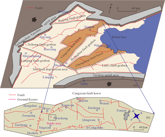
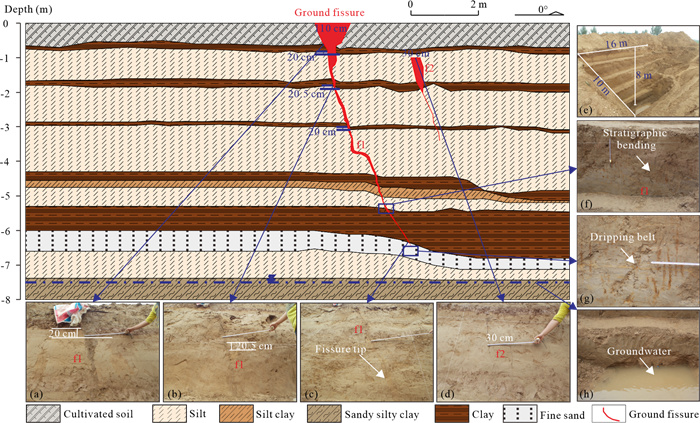
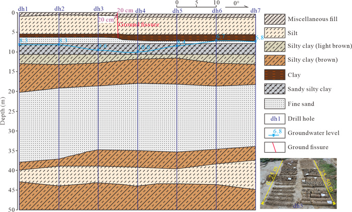
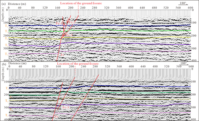
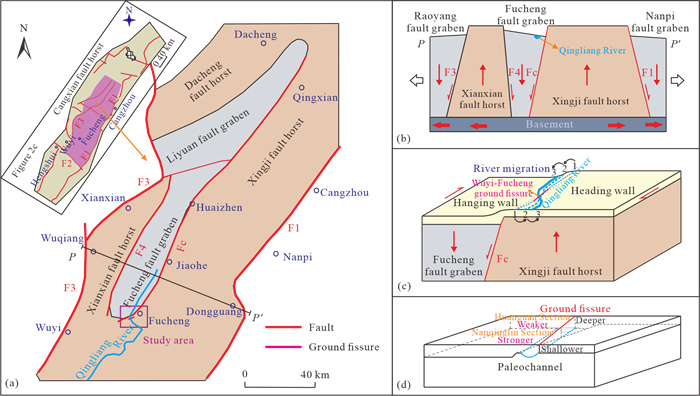
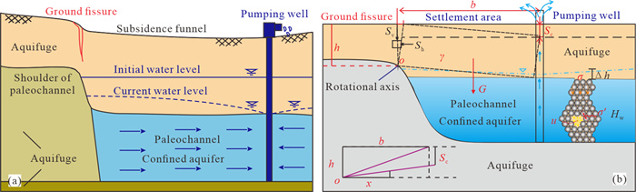
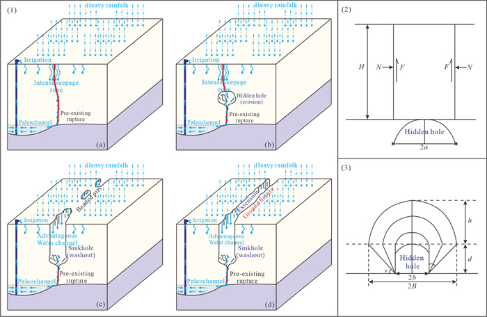
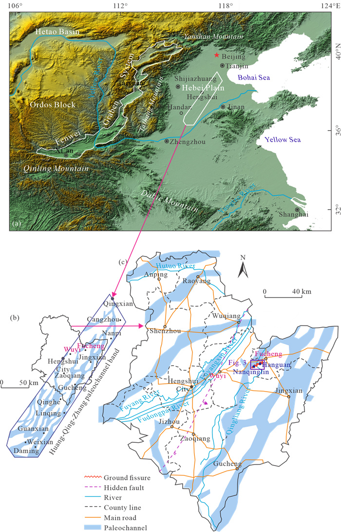
  • Nearly 1 100 fissures have formed on the Hebei Plain in China. Within the Yellow River-Qinghe River-Zhanghe River shallow buried paleochannel band on the plain, 93 ground fissures controlled by paleochannels have developed, of which the Wuyi-Fuping ground fissure is a typical paleochannel-controlled fissure located in Hengshui, Hebei Province, with a total length of 3 km, a dominant strike of NE78°, and nearly upright in the shallow layer. The surface damage observed in this fissure primarily manifests as beaded pits, and its activity shows distinct segmentation characteristics. On the trench profiles, the offset distance of shallow layers remains consistently around 20 cm within the depth range of 0 to -3 m. An evident flexure is observed in the strata at depths ranging from -4.5 to -7 m. The drilling profile reveals that there is an absence of dislocations in the deeper strata. Nonetheless, the shallow seismic physical profiles unveil the presence of underlying faults beneath the study area, underscoring the intricate formation process and genesis mechanism of the Wuyi-Fuping ground fissure. Firstly, the formation and evolution of the Qingling River's paleochannel were shaped by the actions of fault blocks and underlying faults. The interplay of the regional stress field, fault block movement, and fault activity played pivotal roles in driving the development of this paleochannel. Secondly, the paleochannel exerts a controlling influence on the development location and severity of the fissure. During pumping, the confined aquifer within the paleochannel undergoes water loss and compression, resulting in the formation of a surface subsidence funnel. When the tensile stress surpasses the soil's tensile strength at the funnel's edge, the soil fractures give rise to a ground fissure. Finally, large amounts of surface water generated by heavy rainfall and irrigation can cause existing hidden ground fissures to rupture, emerge, and expand. This paper provides a heretofore generally unknown example, promotes research on the mechanisms of paleochannel-controlled fissures, and has guiding significance for disaster prevention and reduction in this area.


  • Conflict of Interest
    The authors declare that they have no conflict of interest.
  • Ground fissures are a type of slow-varying linear geohazard that develops in the loose sediment layer under the influence of internal and external geological forces or human activity (Peng et al., 2016; Ayalew et al., 2004; Holzer and Pampeyan, 1981). The factors due to fissure development include regional tectonics, fault activity, paleochannels, bedrock heaving, pumping, mining, irrigation, etc. (Wang et al., 2020, 2019a). Paleochannel-controlled ground fissures frequently manifest in plain regions, causing severe damage to houses, roads, and farmland along their path (Xu et al., 2019; Yang et al., 2018; Li et al., 2000). This type of ground fissure is directly related to river alteration and is most common in the Hebei Plain of China (Zhang W S et al., 2022; Xu et al., 2019; Bufarale et al., 2017; Zhao et al., 1999).

    Paleochannels are the product of river diversions, which often result from tectonic movements or river siltation (Bufarale et al., 2017; Hawlader et al., 2008). Tectonic movements cause differential movement of fault blocks in a vertical direction, which can lead to large-scale river diversions in a region (Xu et al., 2016; Wu et al., 1996). The majority of river diversions resulted from natural river processes take place in lowland rivers with significant sediment accumulation, among which the Hebei Plain, situated in the lower reaches of the Yellow River in China, stands out as the prime example, encompassing both the Hebei Plain and the Huanghuaihai Plain (Gaur et al., 2015; Zhang, 2000). The paleochannels are categorized into two types: the exposed type and the buried type. Buried-type paleochannels are generally zones enriched with groundwater (Zhang et al., 2005; Wu et al., 1996). Paleochannels with a burial depth of fewer than 30 m are commonly designated as "shallow-buried" paleochannels (Kemp and Rhodes, 2010). Due to their shallow burial depth, high sediment porosity, and wide paleochannel configuration, they are strongly linked with the formation of ground fissures (Xu et al., 2019).

    The Hebei Plain is an area with extensive paleochannel development, and active faults are interspersed within it in a tessellated pattern (Peng et al., 2016; Xu, 2012). The vertical differential movement of tectonic sub-blocks, driven by fault activity, has led to uplifting of some areas and subsidence of others. This phenomenon has contributed to river migration and subsequently to the rich paleochannel geomorphology of the Hebei Plain (Xu et al., 2019; Bufarale et al., 2017; Oldknow and Hooke, 2017). The existence of paleochannels resulted in variations in soil layer thickness, and the pumping action induced soil cracking, leading to the formation of ground fissures (Panda et al., 2015; Bankher et al., 1999). The Hebei Plain has developed about 1 100 ground fissures, making it the region with the largest number of developed ground fissures in the world (Peng et al., 2020). Paleochannel-controlled ground fissures are a common and unique type of hazard, and 93 ground fissures have occurred in the Yellow River-Qinghe River-Zhanghe River shallow buried paleochannel band (Tong et al., 2023; Xu et al., 2019). The distribution of these ground fissures is highly correlated with the location of paleochannels (Li, 2003). Therefore, the formation and expansion of this type of ground fissure must be directly related to the morphology, structure, buried depth, and evolution of paleochannels (Xu et al., 2019; Lu et al., 1982). The structure of the paleochannel deposit is loose and weak in compressive resistance, prone to liquefaction under the action of earthquakes and thus to subsidence to form ground fissures (Pacheco-Martínez et al., 2013; Wu, 2008; Pratt, 1998). However, the study of the characteristics and causes of paleochannel-controlled ground fissures is relatively cursory, and there is very little detailed analysis of their formation process, which is important for disaster prevention and mitigation of ground fissures in plain areas.

    Taking the Wuyi-Fucheng ground fissure in the Hebei Plain as an example, this paper makes a detailed study of the characteristics and causes of paleochannel-controlled ground fissures, thus bridging the gap in this field of research and providing a theoretical basis for ground fissure prevention and control.

    The study area of the Wuyi-Fuping ground fissure is located in the Hebei Plain, which is bounded by the Taihang Mountain in the west, the Bohai Sea in the east, the Yanshan Mountain in the north, and the Yellow River in the south (Figure 1a). Within the shallow-buried paleochannel belt of the Yellow River-Qinghe River-Zhanghe River on the Hebei Plain, the Wuyi-Fucheng fissure has developed (Figures 1b and1c).

    Figure  1.  Sketch map showing the location of the Wuyi-Fuping ground fissure and distribution of the Yellow River-Zhanghe River-Qinghe River paleochannels band on the North China Plain, China.

    Since the Cenozoic Era, the regional stress field in the Hebei Plain has been influenced by both the near-field effect of the westward subduction of the Pacific and Philippine plates and the far-field effect of eastward compression from the India Plate (Chen et al., 2022). This has resulted in a prevalent tensile stress orientation in the NWW-SEE direction (Xu et al., 2019). This stress field has given rise to a series of fault grabens and fault horsts in the plain, characterized by approximate NNE-SSW strikes, leading to the formation of numerous normal faults between these fault blocks (Qi et al., 2016; Figure 2a). The study area of the Wuyi-Fuping ground fissure is situated on the Cangxian fault horst, which is delimited by Cangdong fault, Wuji-Hengshui fault, and Xianxian fault (Figure 2b). However, the ground fissure is not directly linked to these three faults, but sets the tectonic dynamic background of the study area, formed in a right-sliding tensional shear environment. This tectonic setting is an indirect factor in river migration and ground fissure formation.

    Figure  2.  Tectonic background of the Wuyi-Fucheng ground fissure study area. F1. Cangdong fault; F2. Wuji-Hengshui fault; F3. Xianxian fault.

    The study area is located in a mid-latitude zone with a warm-temperate semi-arid climate. The average annual precipitation is 571 mm, the average annual evaporation is 2 267 mm, and the rainfall from June to September accounts for 82.9% of the annual precipitation. The primary river in the area is the Qingliang River. Regarding stratigraphic lithology, there is a substantial accumulation of loose materials since the Quaternary period, consisting mainly of silty clay, silt, sand, and gravel layers, with an overall thickness of approximately 450 m. The Quaternary strata represent the former aquifer, with the submerged layer (0–60 m) containing brackish water. Below the brackish layer, deep-pressure aquifers are extensively distributed, reaching depths of up to 450 m. These deep-pressure aquifers serve as the primary water source for agricultural and industrial purposes. In addition, it should be noted that shallowly buried paleochannels (< 30 m) are widely distributed in the stratigraphy of the study area, and many small ground fissures are closely related to them.

    The Wuyi-Fuping ground fissure first emerged between Wuyi County and Fuping County in Hengshui City in 1999. This ground fissure originates from Nanqinglin Village and extends to Hanguan Village, covering a distance of 3 km with a striking direction of 78°. It intersects the Qingliang River (Figure 3-(1)).

    The Wuyi-Fuping ground fissure spreads mainly over the farmland, so only a small number of buildings were destroyed (Figure 3-(1)). The building damage occurred mainly in the Nanqinglin Village of Wuyi County (Figures 3a, 3f3h). The crack damage to the wall is mainly tensile, and the maximum opening is 6 cm (Figure 3g). Along the ground fissure, two large pits have appeared in the farmland, with a maximum length of 2.3 m (Figure 3i). Whenever irrigation or rainfall occurs, water leaks out along the cracks, seriously affecting local agriculture. As a result, local people surround the pit with earth to prevent water from entering (Figure 3j). The situation in the Nanqinglin Section is therefore serious. However, after the fissure crosses the Qingliang River, its activity in the Hanguan Section weakens, and only the disaster indicators remain in place (Figures 3c3e). Besides, It is also worth noting that Hanguan Primary School has been abandoned due to the threat of the ground fissure crossing the campus (Figure 3k). The extension direction of the crack intersects with that of the water pipeline (Figure 3l). In general, the behavior of ground fissures exhibits a pattern of being more pronounced in the western regions and less prominent in the eastern areas.

    Figure  3.  Diagrams and field photographs showing the distribution of Wuyi-Fuping ground fissure and exploration work layout; (a)–(l) disasters and manifestations of the ground fissure.

    To reveal the profile rupture structure of the Wuyi-Fuping ground fissure, a trench, a drilling line, and two geophysical lines were laid across the fissure. The profile rupture structure of the fissure and its related relationship with the strata can well reflect its universality and particularity, which helps to explore the main factors and formation process of the Wuyi- Fuping ground fissure.

    The trench is located in the eastern field of Nanqinglin Village, Wuyi County, with a length of 16 m, a width of 10 m, and a depth of 8 m (Figures 3-(1) and 4e). It is located relatively close to the Qingliang River. The trench runs north-south and crosses the Wuyi-Fuping ground fissure, exposing 14 sets of strata, mainly consisting mainly of cultivated soil, silt, silty clay, clay, sandy silty clay, and fine sand (Figures 4 and 5). On the eastern wall of the trench, the f1 fissure has an obvious "funnel shape" and is almost vertical (Figure 4). The fissure has an opening of 80 cm on the surface and its width narrows significantly at the position of the first clay layer (Figure 4a). On the western wall of the trench, ground fissure f1 also has an obvious "funnel shape" with an opening of 110 cm on the surface, which narrows rapidly with increasing depth (Figure 5). At the same time, fissure f2 develops on the hanging wall of fissure f1, with an upper width of 30 cm (Figure 5d).

    Figure  4.  Cross section and field photographs showing the east wall profile of exploration trench.

    From both side profiles, it can be observed that fissure f1 has offset three layers of clay, and interestingly, the offset distance of these three layers is almost identical at about 20 cm (Figures 4a–4c and 5a5b). This indicates that the fissure does not have the characteristics of a synsedimentary fault, which typically increases the offset distance with increasing depth (Wang et al., 2020). Therefore, this fissure should be classified as a non-tectonic ground fissure. In addition, it should be noted that there is an obvious bending phenomenon in the strata between -4.5 and -7 m depth, which is probably related to the shallow-buried paleochannel left by the changes of the Qing- liang River (Figures 4f and 5f). Furthermore, the fissure also narrows and tapers at the bottom of the last clay layer (Figures 4d and 5c). Interestingly, many brownish-yellow vertical stripes appear in the silt layer just below the end of the fissure, which is the result of surface water infiltrating through the fracture into the silt layer (Figure 5g). There is relatively stable groundwater at the bottom of the trench, which is closely related to the hydraulic connection with the nearby Qingliang River (Figures 4h and 5h).

    Figure  5.  Cross section and field photographs showing the west wall profile of exploration trench.

    To investigate the potential extension of the Wuyi-Fuping ground fissure into deeper strata and assess the presence of faulting, a 60-m-long drilling line was established to the east of Nanqinglin Village, Wuyi County. This drilling line consisted of a total of 7 boreholes, spaced 10 m apart, each with a depth of 50 m (Figures 3-(1)- and 6). Notably, the drilling line intersects the ground fissure at a significant angle, precisely between borehole 3 and borehole 4. In this particular section, the ground fissure has induced a noticeable steep slope of approximately 20 cm on the road surface, which served as the reason for selecting this location for the drilling investigation.

    The drilling profile revealed a total of 11 sets of strata, encompassing miscellaneous fill, silt, silty clay, clay, sandy silty clay, and fine sand. The faulting within the strata was limited to the near-surface layers, and the deeper strata exhibited excellent continuity without any faulting. This confirms that the ground fissure does not extend downward and its development depth is about 6.5 m as exposed by the exploration trench. Similar to the findings of the exploration trench, the drilling results show significant thickness changes in the clay and fine sand layers at depths of 5 to 7 m, which further confirms the formation of the Wuyi-Fuping ground fissure is related to the changes in the Qingliang River. In addition, the depth of the groundwater level was determined in each borehole, revealing a noticeable reduction in the groundwater level directly beneath the ground fissure. This phenomenon suggests a potential transverse hydraulic connection between the fissure and the Qingliang River (Figure 6).

    Figure  6.  Drilling profile of Wuyi-Fuping ground fissure.

    Nevertheless, both the trench and drilling profiles have indicated that the fissure falls within the category of non-tectonic fissures and is highly likely associated with the paleochannel formed by the transformation of the Qingliang River (Figures 46). Notably, the Wuyi-Fuping ground fissure exhibits unique characteristics, with a considerable length and exceptional linear extension, distinguishing it from the general paleochannel-controlled ground fissures (Figure 3; Xu et al., 2019). Therefore, to further study the deep-seated genesis of the Wuyi- Fuping ground fissure, two shallow seismic geophysical prospecting lines (numbered A-A' and B-B') are arranged along the fissure with a length of 600 m each, both intersecting the ground fissure at a significant angle (Figure 3).

    The energy source for the seismic surveys utilized hammer blow. Data were collected for 1 s at an interval of 1 ms, using a high-precision distributed digital seismograph acquisition system with 120 channels and a P-wave frequency of 60 Hz. The signal was linearly combined by using three recording geophones spaced 4 m apart. Shot point spacing was 8 m, with five shots as required per point. The data processing sequence consisted of (1) data collection and editing, (2) corrections and compensations, (3) signal denoising, and (4) analysis and imaging.

    Figure 7 illustrates five sets of stratigraphic interfaces, denoted as T1–T5, which represent CT velocity stratification interfaces. These interfaces are abruptly truncated by the underlying fault (Fc), displaying typical characteristic features of synsedimentary faults. Within the depth range of 100–300 m, three secondary faults (Fc-1, Fc-2, and Fc-3) become evident. This suggests that the underlying fault (Fc) predominantly exhibits shearing activity at greater depths (below 300 m), tension-shear activity in the middle layers (100–300 m), and considerably reduced activity in the shallow layers (above 100 m). Notably, the surface location of the Wuyi-Fuping fissure aligns with the secondary fault (Fc-3) of the underlying fault (Fc) (Figure 7).

    Figure  7.  Seismic prospecting profile of Wuyi-Fuping ground fissure. (a) A-A'; (b) B-B'; Fc. underlying fault; Fc-1, Fc-2 and Fc-3 are the secondary faults of Fc; T1–T5. CT velocity stratification interfaces.

    Based on the findings of the aforementioned investigation, it is clear that the Wuyi-Fuping ground fissure represents a typical and distinctive paleochannel-controlled ground fissure. This paper delves into the characteristics and genesis of the Wuyi-Fuping ground fissure, categorizing them into three primary aspects: the driving role of tectonics, the control role exerted by paleochannel, and the triggering role played by surface water.

    Influenced by the subduction of the Pacific Plate beneath the Eurasian Plate, the Hebei Plain, the location of the Wuyi-Fucheng ground fissure, exists within a near NW-SE oriented tensional environment (Figure 2a; Hu et al., 2022; Lu et al., 2022; Bagas et al., 2021). While the Wuyi-Fucheng ground fissure is a kind of paleochannel-controlled ground fissure, its genesis is indirectly related to regional tectonics (Qi et al., 2016). This linkage arises from the interplay of the regional stress field, fault block activity, and fault activity, which collectively drove the formation of the paleochannels (Figures 1b, 2, and 8; Slowik, 2023; Xu et al., 2019).

    Figure  8.  Driving mechanism of tectonics on ground fissures. (a) Fault block tectonics in the study area; (b) fault block movement; (c) river migration; (d) differences in ground fissure activity; F1. Cangdong fault; F2. Wuji-Hengshui fault; F3. Xianxian fault; F4. Fucheng fault; Fc. underlying fault.

    The Wuyi-Fucheng ground fissure is located in the Cang-xian fault horst, providing the tectonic background and dynamic conditions for the formation of paleochannels (Figure 2c; Chen et al., 2023). The Cangxian fault horst comprises several secondary blocks, which include the Xianxian fault horst, Dacheng fault horst, Hangji fault horst, Raoyang fault graben, Nanpi fault graben, Liyuan fault graben, and Fucheng fault graben (Figure 8a; Huang et al., 2021). The active faults serve as the boundaries between these secondary blocks (Wang et al., 2022). Under a regional extensional background, the stretching of the basement causes lateral and vertical differential movement of the upper secondary fault blocks, resulting in an uplift of the fault horsts and subsidence of the fault grabens (Figure 8b; Maerten, 2002). The differential movement between these blocks activates the boundary faults, resulting in topographic changes between the fault blocks (Caine et al., 2022). The hanging wall of the fault is relatively lower, while the heading wall is relatively higher. The existence of this fault has been confirmed by geophysical profiles, but its activity has been low since the Quaternary period (Figure 7). These topographic changes have prompted the Qingliang River to undergo a historical pattern of migration and bending. The river channel, which was initially located on the hanging wall, shifted westward, while the river channel on the heading wall migrated eastward. As a consequence, a significant angle has formed at the intersection of the current river channel and the ground fissure (Figure 8c). Meanwhile, due to continuous sedimentation, the burial depth of the Qingliang River paleochannel is shallower in the heading wall and deeper in the hanging wall. This differential burial depth contributes to segmented variations in the activity of the ground fissure. This accounts for the greater intensity observed in the Nangqinglin Section of the ground fissure compared to the Hanguan Section (Figure 8d). The paleochannel that remains covered by Quaternary strata provides paleo-topographic conditions for the formation of the ground fissure (Xu et al., 2019).

    The Hebei Plain, home to the Wuyi-Fucheng ground fissure, has witnessed the development of numerous paleochannels, shaped by the subsidence of tectonic blocks and periodic flooding (Xu et al., 2019). Among these, the most well-known is the Yellow River-Qinghe River-Zhanghe River shallow buried paleochannel band, which extends almost in a NE-SW direction from the Zhengzhou area to Bohai Bay (Du et al., 2023; Wu, 2008; Figure 1). The Wuyi-Fucheng ground fissure is located within this buried paleochannel band and specifically forms on the shoulder of the Qingliang River's paleochannel (Figure 1b). The paleochannel of the Qingliang River has a controlling effect on the development location and intensity of the fissure (Zhao et al., 2023; Zheng et al., 2023; Li, 2003).

    Paleochannel-controlled ground fissures are caused by uneven subsidence induced by pumping groundwater (Bufarale et al., 2017; Zhao et al., 1999). This type of fissure is a non- tectonic fissure that presents itself on the surface as straight and short, generally developed in shallow layers and with limited depth (Xu et al., 2019). The Wuyi-Fuping fissure exemplifies a typical paleochannel-controlled fissure. Surface damage associated with this fissure predominantly appears as beaded pits. In its cross-section, the fissure primarily segments the upper layers (0–3 m depth) with consistent fault displacement (Figures 3i and 3j, 4, and 5). A noticeable downward bending in the strata occurs within the depth range of -4.5 and -7 m (Figures 4 and 5). This observation suggests that the burial depth of the Qingliang River paleochannel is relatively shallow, which facilitates the formation and development of fissures (Peng et al., 2020; Wu, 2008). Under pumping, the confined aquifer in the paleochannel loses water and compresses, forming subsidence funnels on the surface (Zhang Y et al., 2022). Moreover, it is easier to form tension stress concentration zones above the shoulder of paleochannel. When the tensile stress exceeds the tensile strength of the soil, the soil cracks to form fissures (Figure 9a).

    Figure  9.  Control mechanism of paleochannel on ground fissures under pumping action. (a) The pattern of the formation process; (b) mechanical analysis; h. thickness of the soil layer above the shoulder of paleochannel; o. rotational axis; b. horizontal distance from the pumping well to the shoulder; γ. unit weight; G. gravity; Sc. critical settlement; σv. vertical stress; σh. horizontal stress; Δh. decrease in water level; Hw. thickness of the confined aquifer; σ. total stress; σ'. effective stress; u. pore water pressure; x. critical horizontal distance from the center of a rotating soil mass to the rotational axis.

    To determine the maximum critical settlement required for fissure propagation through mechanical analysis, several considerations come into play. As pumping continues, the subsided soil in the settlement area can be approximated as rotating around the shoulder of paleochannel. Assuming that the paleochannel has separated from the upper soil without any supporting force after losing water, the Rankine active earth pressure theory and the torque balance principle can be effectively applied (Figure 9b).

    γbhx=13Ea(h2cγKa)
    (1)

    And then

    x=Ea3γbh(h2cγKa)
    (2)

    where $E_a=\frac{1}{2} \gamma h^2 K_a-2 c h \sqrt{K_a}+\frac{2 c^2}{\gamma} $, $ K_a=\tan { }^2\left(45^{\circ}-\frac{\phi}{2}\right) $, x is the critical horizontal distance from the center of a rotating soil mass to the rotational axis, Ea is the total active earth pressure, b is the horizontal distance from the pumping well to the shoulder, h is the thickness of the soil layer above the shoulder of paleochannel, γ is the unit weight, c is the cohesion, φ is the friction angle, Ka is the Rankine active earth pressure coefficient.

    Assume a maximum critical amount of subsidence, Sc, which can cause the overlying strata to rupture, based on the geometric relationships shown in the figure

    h2+b2(hSc)2=4x2
    (3)

    And then

    Sc=h2+b24x2+h
    (4)

    Substituting Eq. (2) into Eq. (4), then

    Sc=h2+b24Ea29γ2b2h2(h2cγKa)+h
    (5)

    From the above equation, it can be seen that as the burial depth of the paleochannel (h) decreases, the pumping well is closer to the shoulder of the ancient river channel (b), and the critical subsidence amount Sc required for fissure openings becomes smaller, which means that ground fissures are more likely to occur. The generation of surface subsidence Sc is determined by the thickness of the confined aquifer in the paleochannel, the intensity and duration of pumping.

    Fissures are a type of slow-changing geological hazard (Zhou et al. 2022). However, through many field visits and investigations, it has been found that many fissures occur after heavy rainfall, suddenly appearing on the surface overnight (Liu et al., 2022; Peng et al., 2018). The Wuyi-Fuping fissures also exhibit this phenomenon. Therefore, when analyzing the formation process of these fissures, the erosion caused by surface water from heavy rainfall and irrigation cannot be ignored (Zhang et al., 2023; Wang et al., 2019b).

    The Wuyi-Fuping fissures fall under the category of typical paleochannel-controlled ground fissures. Surface activity is notably prominent in the Nanqinglin Section, often marked by the appearance of sinkholes and pits, especially within farmland areas (Figures 3i and 3j). Local villagers reported that heavy rainfall or irrigation events lead to the fissures surfacing. Consequently, the strong erosion of surface water emerges as a significant triggering factor for the exposure of the Wuyi-Fuping fissure on the surface. Firstly, a large amount of surface water generated by heavy rainfall or irrigation will flow down along the pre-existing ruptures (hidden cracks) serving as dominant channels, forming an intense seepage zone (Figure 10a). Secondly, as the seepage and erosion continue, fine particles are gradually eroded and carried away, forming hidden holes at a certain depth (Figure 10b). Thirdly, as the underground water continues to erode, the height and width of the hidden holes will gradually increase. When the upper part of the soil cannot support its weight, the soil will collapse, forming sinkholes or bead-like pits (Figure 10c). Finally, under the strong washout effect of surface water, the sinkholes or pits will persistently enlarge and eventually merge to create surface fissures (Figure 10d).

    Figure  10.  Triggering mechanism of surface water on ground fissures. (1) The pattern of the exposure process; (2), (3) mechanical analysis; (a) seepage stage; (b) erosion stage; (c) washout stage; (d) extension stage; H. thickness from the ground surface to the top of the hidden hole; N. soil pressure on the sidewall; F. frictional force per unit length of the sidewall; a. half the length of the hidden hole; h. critical safety thickness; d. the height of the hidden hole; φ. the friction angle; b. half the length of the hidden hole; B. half the length of surface destruction range.

    From a mechanical point of view, analyzing the erosion of surface water, when the hydraulic gradient of infiltrating water reaches a critical value Jk, fine particles in the soil will migrate and the soil will be submerged and eroded into hidden holes. Where Gs is the specific gravity of the soil particles and n is the porosity of the soil.

    Jk=(Gs1)(1n)
    (6)

    Based on the above equation, it can be analyzed that compared to intact soil, the soil in the fissure zone is more susceptible to erosion compared to the intact soil, because the porosity of the soil in the fissure zone is greater, and its Jk value is smaller. The depth of the hidden hole is not only related to the properties of the soil but also to the rainfall and the infiltration rate.

    As the process of erosion continues, hidden holes are formed within a certain depth range. The mechanical analysis is shown in Figure 10-(2).

    G = 2αγH, 2F = γH2K0tan φ + 2cH(7)

    where G is the weight of the upper soil mass, F is the frictional force per unit length of the side wall, a is half the length of the hidden hole, γ is the unit weight, H is the thickness from the ground surface to the top of the hidden hole, K0 is the lateral pressure coefficient, c is the cohesion, and φ is the friction angle.

    When the thickness from the ground surface to the top of the hidden hole reaches a certain level, that is, H = H0, G = 2F, the collapse of the upper soil forms a sinkhole, where H0 is the critical thickness of the soil.

    H0=2αγ2cγK0tanϕ
    (8)

    From another perspective, the weight of the soil above hidden holes is supported by the arch itself. The critical safe thickness h0 is obtained using Protodyakonovʼs arch method (Figure 10-(3)), where b is half the length of the hidden hole, d is the height of the hidden hole, and φ is the internal friction angle.

    h0=b+dtan(90ϕ)tanϕ
    (9)

    Based on the analysis of Eqs. (8) and (9), it can be deduced that the formation process of a sinkhole, resulting from the collapse of a hidden hole, is influenced by factors such as cohesive force, internal friction angle, soil unit weight, as well as the dimensions of the hidden hole, including its width and height. Therefore, surface water from heavy rainfall and irrigation plays an important triggering role in the exposure and expansion of ground fissures.

    This study investigates the development characteristics and origin of the Wuyi-Fucheng ground fissure in the Hengshui area, employing geological methods encompassing surveying, mapping, trenching, drilling, and seismic exploration. The main conclusions are as follows.

    (1) The Wuyi-Fucheng ground fissure is a typical paleochannel-controlled fissure with a length of 3 km and a strike of 78°, behaving with the Nanqinglin Section being more active than the Hanguan Section.

    (2) This fissure develops only within a depth range of about 6.5 meters, and there is no underlying fault beneath it. The equivalent dislocation and bending observed in the shallow strata provide compelling evidence for the presence of a paleochannel closely associated with the formation of the fissure.

    (3) The genesis of the Wuyi-Fuping ground fissure can be divided into the following three primary aspects: the driving influence of tectonics, the control impact of paleochannel, and the triggering role of surface water. Tectonic forces drove changes in the river channel, the paleochannel controlled the formation of the fissure, and the exposure of the ground fissure was triggered by surface water resulted from heavy rainfall and irrigation.

    ACKNOWLEDGMENTS: This study was funded by the National Science Foundation of China (Nos. 2022XAGG0400, 42207202, 42293351), the Open Fund of the Key Laboratory of Earth Fissures Geological Disaster, Ministry of Natural Resources, Geological Survey of Jiangsu Province, China (No. EFGD20240604), the Open Fund of the Observation and Research Station of Ground Fissure and Land Subsidence, Ministry of Natural Resources (No. GKF2024-06), the Fundamental Research Funds for the Central Universities of China University of Geosciences, Beijing (No. 2-9-2021-014), the Fundamental Research Funds for the Central Universities of Chang'an University (No. 300102264501-01). The final publication is available at Springer via https://doi.org/10.1007/s12583-023-1960-x.
  • Ayalew, L., Yamagishi, H., Reik, G., 2004. Ground Cracks in Ethiopian Rift Valley: Facts and Uncertainties. Engineering Geology, 75(3/4): 309–324. https://doi.org/10.1016/j.enggeo.2004.06.018
    Bagas, L., Bierlein, F., Jiang, S. H., et al., 2021. Review of the Regional Nomenclature and Tectonic Setting for Mesozoic Gold Deposits in the Malanyu Anticline Area of Eastern Hebei Province, North China. International Geology Review, 63(18): 2257–2278. https://doi.org/10.1080/00206814.2020.1830314
    Bankher, K. A., Al-Harthi, A. A., 1999. Earth Fissuring and Land Subsidence in Western Saudi Arabia. Natural Hazards, 20(1): 21–42. https://doi.org/10.1023/a:1008167913575
    Bufarale, G., OʼLeary, M., Stevens, A., et al., 2017. Sea Level Controls on Palaeochannel Development within the Swan River Estuary during the Late Pleistocene to Holocene. CATENA, 153: 131–142. https://doi.org/10.1016/j.catena.2017.02.008
    Caine, J. S., Benowitz, J. A., 2022. Tectonics, Fault Zones, and Topography in the Alaska—Canada Cordillera with a Focus on the Alaska Range and Denali Fault Zone. In: Misra, A. A., Mukherjee, S., eds., Atlas of Structural Geological and Geomorphological Interpretation of Remote Sensing Images. Wiley. 135–145. https://doi.org/10.1002/9781119813392.ch13
    Chen, G. F., Bartholomew, M., Liu, D. M., et al., 2022. Paleo-Earthquakes along the Zheduotang Fault, Xianshuihe Fault System, Eastern Tibet: Implications for Seismic Hazard Evaluation. Journal of Earth Science, 33(5): 1233–1245. https://doi.org/10.1007/s12583-022-1687-0
    Chen, S., Zhao, R., Chen, C. W., et al., 2023. Tectono-Sedimentary Evolution of the Paleogene Qikou Sag, Bohai Bay Basin, NE China. Marine and Petroleum Geology, 148: 106057. https://doi.org/10.1016/j.marpetgeo.2022.106057
    Du, L. J., Wang, F., Zhang, Q. X., et al., 2023. Adaptation of Urban Distribution to the Fluvial Geomorphic Environment and the Reconstruction of the River System Structure by Urban Distribution in Haihe Plain in the Past 2, 200 years. River Research and Applications, 39(7): 1199–1211. https://doi.org/10.1002/rra.3935
    Gaur, V. P., Kar, S. K., Srivastava, M., 2015. Development of Ground Fissures: A Case Study from Southern Parts of Uttar Pradesh, India. Journal of the Geological Society of India, 86(6): 671–678. https://doi.org/10.1007/s12594-015-0359-4
    Hawlader, B. C., Muhunthan, B., Imai, G., 2008. State-Dependent Constitutive Model and Numerical Solution of Self-Weight Consolidation. Géotechnique, 58(2): 133–141. https://doi.org/10.1680/geot.2008.58.2.133
    Hu, H., Yu, X., Han, X. Q., 2022. Quantitative Constraints of Subduction Cycle Components on Oceanic Mantle Heterogeneity. Earth Science, 47(7): 2616–2630. https://doi.org/10.3799/dqkx.2021.057 (in Chinese with English Abstract)
    Huang, X., Shen, C. B., Du, L., et al., 2021. Geothermal Geological Characteristics of the Xianxian High and Fucheng Sag in the Middle Cangxian Uplift, Bohai Bay Basin. Geoscience, 35(4): 997–1008. https://doi.org/10.19657/j.geoscience.1000-8527.2021.043 (in Chinese with English Abstract)
    Holzer, T. L., Pampeyan, E. H., 1981. Earth Fissures and Localized Differential Subsidence. Water Resources Research, 17(1): 223–227. https://doi.org/10.1029/wr017i001p00223
    Kemp, J., Rhodes, E. J., 2010. Episodic Fluvial Activity of Inland Rivers in Southeastern Australia: Palaeochannel Systems and Terraces of the Lachlan River. Quaternary Science Reviews, 29(5/6): 732–752. https://doi.org/10.1016/j.quascirev.2009.12.001
    Li, C., 2003. Study on the Ground Fissures in Hebei Plain: [Dissertation]. China University of Geosciences, Beijing (in Chinese with English Abstract)
    Li, Y. L., Yang, J. C., Hu, X. M., 2000. Origin of Ground Fissures in the Shanxi Graben System, Northern China. Engineering Geology, 55(4): 267–275. https://doi.org/10.1016/s0013-7952(99)00082-4
    Liu, Y., Peng, J. B., Jiang, F. Q., et al., 2022. Model Test Study on the Formation and Development of Underground Erosion Ground Fissures in the Kenya Rift Valley. Journal of Mountain Science, 19(4): 1037–1050. https://doi.org/10.1007/s11629-021-7004-z
    Lu, X., Zhao, L., Lun, Z., 1982. Regional Geology of Hebei Province, Beijing Municipality and Tianjin Municipality. Geological Publishing House, Beijing (in Chinese)
    Lu, Y., Cui, Y. C., Si, S. T., et al., 2022. Rapid Uplift Period of Eastern Himalayan Syntaxis: Evidence from Sedimentology in Central Myanmar Basin. Earth Science, 47(7): 2573–2585. https://doi.org/10.3799/dqkx.2021.240
    Maerten, L., Gillespie, P., Pollard, D. D., 2002. Effects of Local Stress Perturbation on Secondary Fault Development. Journal of Structural Geology, 24(1): 145–153. https://doi.org/10.1016/s0191-8141(01)00054-2
    Oldknow, C. J., Hooke, J. M., 2017. Alluvial Terrace Development and Changing Landscape Connectivity in the Great Karoo, South Africa. Insights from the Wilgerbosch River Catchment, Sneeuberg. Geomorphology, 288: 12–38. https://doiorg/10.1016/j.geomorph.2017.03.009 doi: 10.1016/j.geomorph.2017.03.009
    Pacheco-Martínez, J., Hernandez-Marín, M., Burbey, T. J., et al., 2013. Land Subsidence and Ground Failure Associated to Groundwater Exploitation in the Aguascalientes Valley, México. Engineering Geology, 164: 172–186. https://doi.org/10.1016/j.enggeo.2013.06.015
    Panda, B. B., Rucker, M. L., Fergason, K. C., 2015. Modeling of Earth Fissures Caused by Land Subsidence due to Groundwater Withdrawal. Proceedings of the International Association of Hydrological Sciences, 372: 69–72. https://doi.org/10.5194/piahs-372-69-2015
    Peng, J. B., Xu, J. S., Ma, R. Y., et al., 2016. Characteristics and Mechanism of the Longyao Ground Fissure on North China Plain, China. Engineering Geology, 214: 136–146. https://doi.org/10.1016/j.enggeo.2016.10.008
    Peng, J. B., Wang, F. Y., Cheng, Y. X., et al., 2018. Characteristics and Mechanism of Sanyuan Ground Fissures in the Weihe Basin, China. Engineering Geology, 247: 48–57. https://doi.org/10.1016/j.enggeo.2018.10.024
    Peng, J. B., Qiao, J. W., Sun, X. H., et al., 2020. Distribution and Generative Mechanisms of Ground Fissures in China. Journal of Asian Earth Sciences, 191: 104218. https://doi.org/10.1016/j.jseaes.2019.104218
    Pratt, B. R., 1998. Syneresis Cracks: Subaqueous Shrinkage in Argillaceous Sediments Caused by Earthquake-Induced Dewatering. Sedimentary Geology, 117(1/2): 1–10. https://doi.org/10.1016/s0037-0738(98)00023-2
    Qi, J. F., Tian, M. K., Chi, X. C., et al., 2016. Research on Ground Fissure Origins and Mechanisms in Hebei Plain, P. R. China. Journal of Groundwater Science and Engineering, 4(3): 188–196. https://doi.org/10.26599/jgse.2016.9280022
    Slowik, M., 2023. The Evolution of Meandering and Anabranching Rivers in Postglacial and Loess Landscapes of Europe. The Holocene, 33(2): 208–230. https://doi.org/10.1177/09596836221131712
    Tong, D. F., Su, A. J., Tan, F., et al., 2023. Genetic Mechanism of Water-Rich Landslide Considering Antecedent Rainfalls: A Case Study of Pingyikou Landslide in Three Gorges Reservoir Area. Journal of Earth Science, 34(6): 1878–1891. https://doi.org/10.1007/s12583-022-1722-1
    Wang, F. Y., Peng, J. B., Meng, Z. J., et al., 2019a. The Origin and Impact of the Shizhuang Ground Fissure, Yingxian Area, Datong Basin, China. Engineering Geology, 261: 105283. https://doi.org/10.1016/j.enggeo.2019.105283
    Wang, F. Y., Peng, J. B., Lu, Q. Z., et al., 2019b. Mechanism of Fuping Ground Fissure in the Weihe Basin of Northwest China: Fault and Rainfall. Environmental Earth Sciences, 78: 407. https://doi.org/10.1007/s12665-019-8421-y
    Wang, F. Y., Peng, J. B., Chen, Z. X., et al., 2020. Development Characteristics and Mechanisms of Damage-Causing Urban Ground Fissures in Datong City, China. Engineering Geology, 271: 105605. https://doi.org/10.1016/j.enggeo.2020.105605
    Wang, F. Y., Peng, J. B., Lu, Q. Z., et al., 2022. Development Characteristics and Dynamic Mechanisms of Tectonic Ground Fissures in Weihe Basin, China. Bulletin of Engineering Geology and the Environment, 81(1): 12. https://doi.org/10.1007/s10064-021-02490-1
    Wu, C., Xu, Q. H., Zhang, X. Q., et al., 1996. Palaeochannels on the North China Plain: Types and Distributions. Geomorphology, 18(1): 5–14. https://doi.org/10.1016/0169-555x(95)00147-w
    Wu, C., 2008. Landform Environment and Its Formation in North China. Science Press, Beijing (Chinese)
    Xu, J. S., 2012. Study on the Formation Mechanism of Ground Fissures in North China Epicontinental Basin: [Dissertation]. Changʼan University, Xiʼan (in Chinese with English Abstract)
    Xu, J. S., Peng, J. B., An, H. B., et al., 2019. Paleochannel-Controlled Earth Fissures in Daming, North China Plain and Their Implication for Underground Paleogeomorphology. Geomorphology, 327: 523–532. https://doi.org/10.1016/j.geomorph.2018.11.020
    Xu, L. Q., Li, S. Z., Cao, X. Z., et al., 2016. Holocene Intracontinental Deformation of the Northern North China Plain: Evidence of Tectonic Ground Fissures. Journal of Asian Earth Sciences, 119: 49–64. https://doi.org/10.1016/j.jseaes.2016.01.003
    Yang, C. S., Lu, Z., Zhang, Q., et al., 2018. Deformation at Longyao Ground Fissure and Its Surroundings, North China Plain, Revealed by ALOS PALSAR PS-InSAR. International Journal of Applied Earth Observation and Geoinformation, 67: 1–9. https://doi.org/10.1016/j.jag.2017.12.010
    Zhang J. Q., Dou, Z., Zhang, X. Y., 2023. Effect of Coefficient of Variation of Particle Size of Porous Media on Contaminant Transport. Earth Science, 48(9): 3444–3453 https://doi.org/10.3799/dqkx.2021.166 (in Chinese with English Abstract)
    Zhang, R. J., 2000. Morphologic Evolution of North China Plain and Causes of Channel Changes and Overflows of the Yellow River. Geology and Mineral Resources of South China, 4: 52–57 (in Chinese with English Abstract)
    Zhang, S. M., Liu, X. D., Ren, J. J., et al., 2005. Quaternary Activities of Northern Segment of the Shunyi-Liangxiang Fault. Eathquake Research in China, 21(1): 84–92 (in Chinese with English Abstract)
    Zhang, W. S., Jiao, Y. Y., Zhang, G. H., et al., 2022. Analysis of the Mechanism of Water Inrush Geohazards in Deep-Buried Tunnels under the Complex Geological Environment of Karst Cave-Fractured Zone. Journal of Earth Science, 33(5): 1204–1218. https://doi.org/10.1007/s12583-022-1619-z
    Zhang, Y., He, G. F., Wu, J. C., et al., 2022. Laboratory Experimental Study on Pumping-Induced Earth Fissures. Hydrogeology Journal, 30(3): 849–864. https://doi.org/10.1007/s10040-022-02473-w
    Zhao, Y. C., Wang, Q. R., 2023. Water Release and Consolidation Model of Aquitard Considering Moving Non-Darcy Flow Interface. Earth Science, 48(9): 3494–3503. https://doi.org/10.3799/dqkx.2023.046 (in Chinese with English Abstract)
    Zhao, Y. K., Wu, C., Zhang, X. Q., 1999. Palaeochannels and Ground-Water Storage on the North China Plain. Geological Society Special Publication, 163: 231–239. https://doi.org/10.1144/gsl.sp.1999.163.01.18
    Zheng, D. D., Gui, Y. H., Kuang, J., et al., 2023. Downstream Channel Evolution and Its Causes in the Yuan River during the Qing Dynasty. Journal of Earth Science, 34(4): 1263–1271. https://doi.org/10.1007/s12583-021-1600-2
    Zhou, Z. K., Yao, X., Ren, K. Y., et al., 2022. Formation Mechanism of Ground Fissure at Beijing Capital International Airport Revealed by High-Resolution InSAR and Numerical Modelling. Engineering Geology, 306: 106775. https://doi.org/10.1016/j.enggeo.2022.106775
  • Relative Articles

    [1]Xi Xu, Wei Wu, Xiuli Du. Effect of pulse-like ground motions on the seismic performance of slope reinforced by pile-anchor structure: centrifuge model tests and numerical simulations[J]. Journal of Earth Science. doi: 10.1007/s12583-025-0204-7
    [2]Jie Chen, Tonghua Wu, Sheng Hu, Hengxing Lan, Jianbing Peng, Shibiao Bai, Xiaodong Wu, Fanyu Zhang. 2-D SAR Interferometry for Assessing Ground Deformation of A Reclaimed Area in Lanzhou, China[J]. Journal of Earth Science. doi: 10.1007/s12583-025-0225-2
    [3]Jie Dou, Ke Xing, Lizhe Wang, Haixiang Guo, Dun Wang, Yigui Peng, Xinjian Xiang, Dunzhu Ciren, Songcheng Zhang, Lele Zhang, Bo Peng. Air-Space-Ground Synergistic Observations for Rapid Post-Seismic Disaster Assessment of 2025 Ms6.8 Xigazê Earthquake, Xizang[J]. Journal of Earth Science. doi: 10.1007/s12583-025-0160-2
    [4]Shugao Tian, Hao Wen, Fei Tan, Yuyong Jiao. Research progress on disaster-causing mechanism of urban ground collapse caused by underground pipeline breakage: A review[J]. Journal of Earth Science. doi: 10.1007/s12583-025-0219-0
    [5]Haijun Qiu, Wen Nie, Liang Zhou, Yingdong Wei, Jiading Wang. Regional Emigration—China's New Approach to Geo-Disaster Mitigation[J]. Journal of Earth Science, 2024, 35(5): 1786-1788. doi: 10.1007/s12583-024-0036-x
    [6]Hongfu Zhou, Fei Ye, Wenxi Fu, Bin Liu, Tian Fang, Rui Li. Dynamic Effect of Landslides Triggered by Earthquake: A Case Study in Moxi Town of Luding County, China[J]. Journal of Earth Science, 2024, 35(1): 221-234. doi: 10.1007/s12583-022-1806-y
    [7]Zhijie Jia, Jianbing Peng, Quanzhong Lu, Penghui Ma, Jianwei Qiao, Feiyong Wang, Mingdong Zang, Yang Liu, Junyan Zhao, Fengji Zhu. A Comprehensive Method for the Risk Assessment of Ground Fissures: Case Study of the Eastern Weihe Basin[J]. Journal of Earth Science, 2023, 34(6): 1892-1907. doi: 10.1007/s12583-022-1799-6
    [8]Jianwei Qiao, Zhenjiang Meng, Yuyun Xia, Cong Liu, Quanzhong Lu, Feiyong Wang, Yuanqiang Zhou, Haiyuan Zhao. Characteristics and formation analysis of earth fissure in Anren area in Wei River Basin, China[J]. Journal of Earth Science. doi: 10.1007/s12583-022-1653-x
    [9]Zhijie Jia, Jianbing Peng, Quanzhong Lu, Jianwei Qiao, Feiyong Wang, Mingdong Zang, Yang Liu, Junyan Zhao, Fengji Zhu. Formation Mechanism of Ground Fissures Originated from the Hanging Wall of Normal Fault: A Case in Fen-Wei Basin, China[J]. Journal of Earth Science, 2022, 33(2): 482-492. doi: 10.1007/s12583-021-1508-x
    [10]Paulo Waltrich, John Whitehead, Richard Hughes, Karsten Thompson. A Study of Fluid Flow in Sediments and the Effect of Tidal Pumping[J]. Journal of Earth Science, 2017, 28(5): 842-847. doi: 10.1007/s12583-017-0804-y
    [11]Hao Xie, Lanbo Liu. Near-surface anisotropic structure characterization by Love wave inversion for assessing ground conditions in Urban Areas[J]. Journal of Earth Science, 2015, 26(6): 807-812. doi: 10.1007/s12583-015-0619-7
    [12]Motoyuki Sato. Near range radar and its application to near surface geophysics and disaster mitigation[J]. Journal of Earth Science, 2015, 26(6): 858-863. doi: 10.1007/s12583-015-0595-y
    [13]Bingguo Wang, Menggui Jin, Xing Liang. Using EARTH model to estimate groundwater recharge at five representative zones in the Hebei Plain, China[J]. Journal of Earth Science, 2015, 26(3): 425-434. doi: 10.1007/s12583-014-0487-6
    [14]Ying Wang, Zongyu Chen, Baoqian Duan, Jingli Shao. Experimental Evidence for Hyperfiltration of Saline Water through Compacted Clay Aquitard in the Hebei Plain[J]. Journal of Earth Science, 2014, 25(6): 1076-1082. doi: 10.1007/s12583-014-0490-y
    [15]Yanhong Zhan, Huaming Guo, Yu Wang, Ruimin Li, Chuntang Hou, Jingli Shao, Yali Cui. Evolution of Groundwater Major Components in the Hebei Plain: Evidences from 30-year Monitoring Data[J]. Journal of Earth Science, 2014, 25(3): 563-574. doi: 10.1007/s12583-014-0445-3
    [16]Shufang Wang; Zhonghe Pang; Jiurong Liu; Pei Lin; Sida Liu; Ming Yin. Origin and Evolution Characteristics of Geothermal Water in the Niutuozhen Geothermal Field, North China Plain[J]. Journal of Earth Science, 2013, 24(6). doi: 10.1007/s12583-013-0390-6
    [17]Hailing Liu, Yongjian Yao, Hui Deng. Geological and Geophysical Conditions for Potential Natural Gas Hydrate Resources in Southern South China Sea Waters[J]. Journal of Earth Science, 2011, 22(6): 718-725. doi: 10.1007/s12583-011-0222-5
    [18]Jing'e Wang, Wei Xiang, Xu Zuo. Situation and Prevention of Loess Water Erosion Problem along the West-to-East Gas Pipeline in China[J]. Journal of Earth Science, 2010, 21(6): 968-973. doi: 10.1007/s12583-010-0150-9
    [19]Ping Ye, Aiguo Zhou, Cunfu Liu, Hesheng Cai, Yiqun Gan, Xiaoqian Li, Qinsheng Jin. Genesis of Sr Isotopes in Groundwater of Hebei Plain[J]. Journal of Earth Science, 2007, 18(2): 177-184.
    [20]Huaming Guo, Yanxin Wang. Batch and Column Experiments on Fluoride Removal from Waters Using Modified Zeolite[J]. Journal of Earth Science, 2000, 11(3): 271-274.
  • Created with Highcharts 5.0.7Amount of accessChart context menuAbstract Views, HTML Views, PDF Downloads StatisticsAbstract ViewsHTML ViewsPDF Downloads2024-052024-062024-072024-082024-092024-102024-112024-122025-012025-022025-032025-0301020304050
    Created with Highcharts 5.0.7Chart context menuAccess Class DistributionFULLTEXT: 33.9 %FULLTEXT: 33.9 %META: 31.6 %META: 31.6 %PDF: 34.5 %PDF: 34.5 %FULLTEXTMETAPDF
    Created with Highcharts 5.0.7Chart context menuAccess Area DistributionChina: 26.0 %China: 26.0 %Honduras: 2.3 %Honduras: 2.3 %Latvia: 1.1 %Latvia: 1.1 %Norway: 1.1 %Norway: 1.1 %Reserved: 23.2 %Reserved: 23.2 %Russian Federation: 2.3 %Russian Federation: 2.3 %United States: 40.1 %United States: 40.1 %海得拉巴: 1.1 %海得拉巴: 1.1 %罗奥尔凯埃: 2.8 %罗奥尔凯埃: 2.8 %ChinaHondurasLatviaNorwayReservedRussian FederationUnited States海得拉巴罗奥尔凯埃

Catalog

    通讯作者: 陈斌, bchen63@163.com
    • 1. 

      沈阳化工大学材料科学与工程学院 沈阳 110142

    1. 本站搜索
    2. 百度学术搜索
    3. 万方数据库搜索
    4. CNKI搜索

    Figures(10)

    Article Metrics

    Article views(55) PDF downloads(61) Cited by()
    Proportional views
    Related

    /

    DownLoad:  Full-Size Img  PowerPoint
    Return
    Return