Advanced Search

Indexed by SCI、CA、РЖ、PA、CSA、ZR、etc .

Yan Lyu, Ruixia Ma, Zuopeng Wang, Jianbing Peng, Tianzhuo Gu. A Study on the Genetic Dynamics and Development Characteristics of Granitic Rock Avalanches in the Northern Qinling Mountains, China. Journal of Earth Science, 2025, 36(2): 737-749. doi: 10.1007/s12583-024-0016-1
Citation: Yan Lyu, Ruixia Ma, Zuopeng Wang, Jianbing Peng, Tianzhuo Gu. A Study on the Genetic Dynamics and Development Characteristics of Granitic Rock Avalanches in the Northern Qinling Mountains, China. Journal of Earth Science, 2025, 36(2): 737-749. doi: 10.1007/s12583-024-0016-1

A Study on the Genetic Dynamics and Development Characteristics of Granitic Rock Avalanches in the Northern Qinling Mountains, China

doi: 10.1007/s12583-024-0016-1
More Information
  • Corresponding author: Zuopeng Wang, zpwang@cugb.edu.cn
  • Received Date: 31 May 2023
  • Accepted Date: 26 Apr 2024
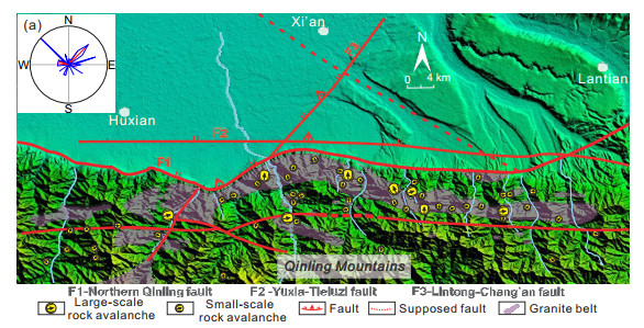
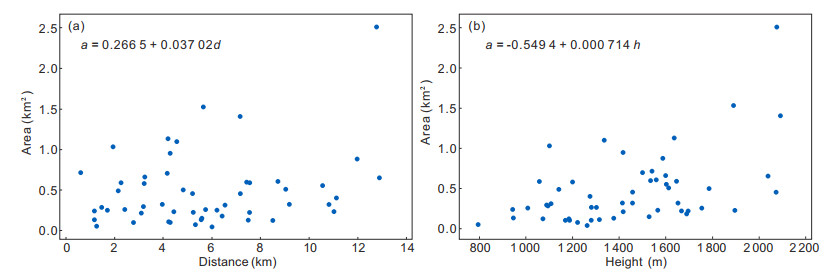
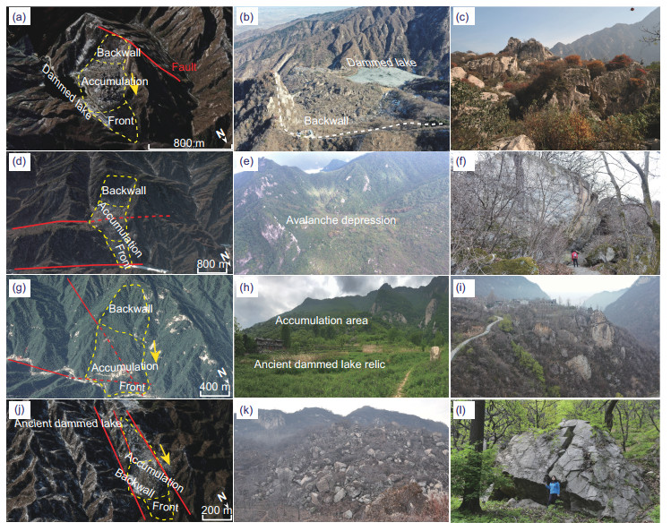
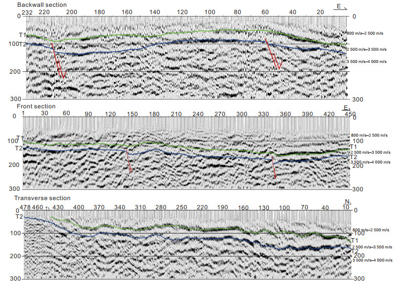
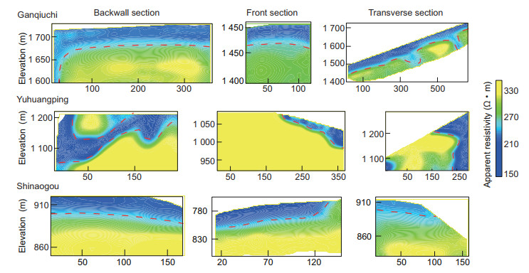
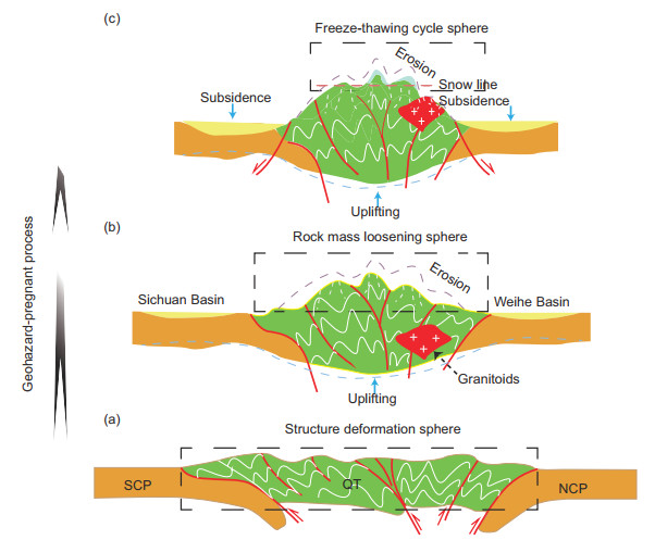
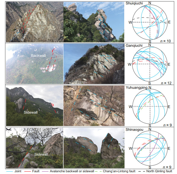
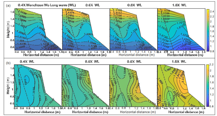
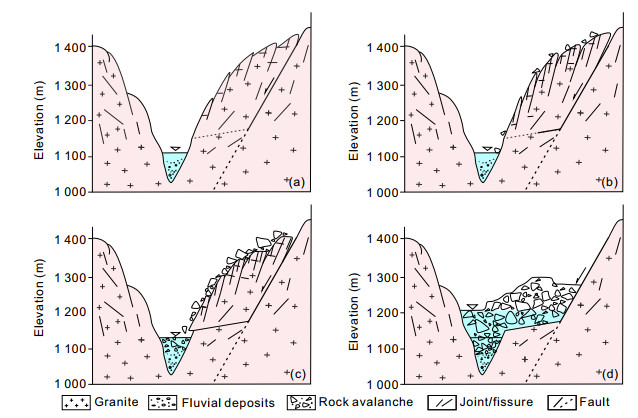
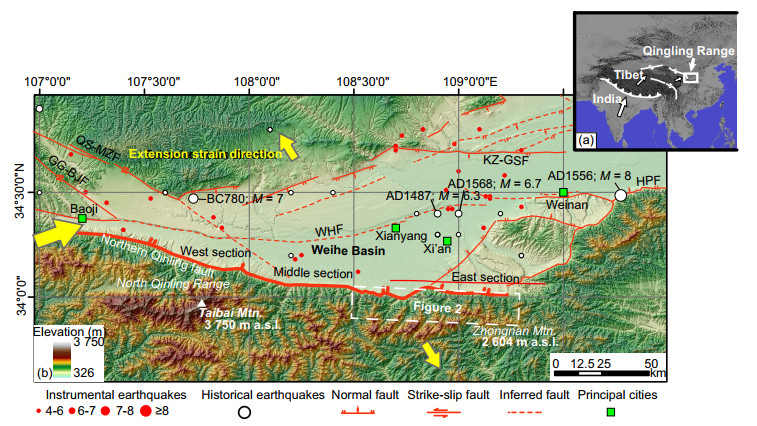
  • Massive granitic rock avalanches are extensively developed in the middle section of the northern Qinling Mountains (NQM), China. The current consensus is that their formation could have been connected with seismic events that occurred in the NQM. However, there is a lack of systematic discussion on the genetic dynamics of these rock avalanches. Hence, taking Earth system scientific research as a starting point, this paper systematically summarizes and discusses development characteristics, formation times and genetic dynamic mechanisms of granitic rock avalanches in the NQM based on geological investigations, high-precision remote sensing interpretations, geomorphological dating, geophysical exploration, and a large-scale shaking table model test. We identified 53 granitic rock avalanches in this area, with a single collapse area ranging from 0.01 × 10⁶ to 1.71 × 10⁶ m2. Their development time can be divided into six stages, namely, 107 000 years BP, 11 870–11 950 years BP, 11 000 years BP, 2 300 years BP, 1 800 years BP, and 1 500 years BP, which were closely related to multiple prehistoric or ancient earthquakes. We suggest that long-term coupling of internal and external earth dynamics was responsible for the granitic rock avalanches in the NQM; the internal dynamics were mainly related to subduction, collision and extrusion of different plates under the Qinling terrane, leading to the formation and tectonic uplift of the Qinling orogenic belt; and the external dynamics were closely associated with climate changes resulting in mountain denudation, freeze-thaw cycles and isostatic balance uplift. In this process, the formation and evolution of the Qinling orogenic belt play a geohazard-pregnant role, structural planes, including faults and joints, play a geohazard-controlled role, and earthquakes play a geohazard-induced role, which jointly results in the occurrence of large-scale granitic rock avalanches in the NQM. This research can not only decipher the genetic dynamic mechanism of large hard granitic rock avalanches but also reveal temporal and spatial patterns of the evolution of breeding and the generation of large-scale rock avalanches in the margins of orogenic belts.


  • Conflict of Interest
    The authors declare that they have no conflict of interest.
  • The Qinling Mountains, as an important part of the central orogenic belt in China (Dong et al., 2022; Li et al., 2017), are the main dividing line between the northern and southern parts of China in terms of geology, geography, climate, and humanities; thus, they constitute a natural laboratory for scientists to explore the mysteries of nature (Dong et al., 2022, 2011). A series of granitic rock avalanches (GRAs), such as the Cuihua Mountain GRA, the Wehuase GRA and the Fenyu GRA, are extensively developed in the middle section of the northern Qinling Mountains (NQM). They are characterized by zonal distribution along the northern Qinling fault, with large volumes and obvious features. Relevant studies have been carried out on GRAs in the NQM. For example, based on field investigations, Lü et al. (2014) and Weidinger et al. (2002) suggested that the Qishan earthquake 780 years before the Christian era (BC) resulted in the Cuihua Mountain GRA, a large earthquake 1 072 years after the Christian era induced the Wehuase GRA, and the Huaxian earthquake 1 556 years after the Christian era led to massive rock avalanches in the NQM. Lü et al. (2015) connected the occurrence of the Cuihua Mountain GRA with the demise of the ancient capital of the Western Zhou dynasty in China and speculated that both were closely related to a large-scale earthquake approximately 2 900 years before present. Additionally, Xie and Xiao (1991) and Wu et al. (2009) considered that the formation of GRAs was more likely to result from multiple earthquake events.

    Obviously, the current consensus is that the occurrence of GRAs is connected with ancient seismic events in the NQM. However, there is a lack of systematic discussion on the genetic dynamic mechanism (including internal and external earth dynamics) of GRAs in the NQM. This is because a large earthquake can result in earth motion, mountain fracture and large-scale rock avalanches (Valagussa et al., 2019; Zhu et al., 2013), but it is only an instantaneous disaster-induced factor in the inoculation and evolution process of the geohazard system, while a long-term pregnant mechanism or process, under the coupled action of internal and external earth dynamics, plays an important role during the formation and evolution of geohazards (Vick et al., 2020; Fan et al., 2019; Yin, 2011; Huang and Li, 2008). Subduction, collision and compression of different plates can cause strong metamorphism and deformation of orogenic belts characterized by extensive development of folds, faults and joints (Li et al., 2017; Dong et al., 2016; Rao et al., 2014), resulting in structural fragmentation of mountain bodies. Tectonic or isostasy uplift of mountain bodies leads to redistribution of rock mass stress and unloading rebound (Tang et al., 2019; Davis, 1899), generating more developed rock structural planes. Moreover, during the formation and uplift of mountain bodies, deep incisions in river systems usually generate high and steep free faces, providing advantageous conditions for geohazard occurrence. Thus, long-term geological and geomorphological evolution processes play a fundamental role in the development of geohazards, especially in tectonically active orographic areas (Peng et al., 2019). However, the existing research on rock avalanche mechanisms in the NQM has rarely discussed genetic dynamic processes from the perspective of long-term time series or geohazard system evolution (Lü et al., 2015; Weidinger et al., 2002). Hence, a lack of these studies or systemic discussion leads to insufficient understanding of the formation of GRAs in the NQM, especially through genetic dynamic analysis.

    In this paper, taking Earth system scientific research as a starting point and based on a series of research results, including geological investigations, high-precision remote sensing interpretations, geomorphological dating, geophysical exploration, and a large-scale shaking table model test, combined with historical records, we systematically summarized and discussed the development characteristics, formation times and genetic dynamic mechanisms of GRAs in the NQM. This research can not only decipher the genetic dynamic mechanism of large granitic rock avalanches but also reveal temporal and spatial patterns of the evolution of breeding and the generation of large-scale rock avalanche belts on the margins of orogenic belts.

    The Qinling Mountains, as a large latitudinal mountain system in Central China (Figure 1a), are connected to the Qinghai-Tibet Plateau in the west and the Funiu Mountains in the east, with a length of 2 000 km from east to west (Dong et al., 2022; Li et al., 2017). It is not only the boundary between northern and southern China in terms of geology, geography and climate but also the watershed of the two major water systems of the Yangtze River and the Yellow River. Moreover, the Qinling Mountains, which are mainly composed of Proterozoic metamorphic rock series and Paleozoic–Mesozoic granites (Zhang et al., 2014), are a complex of middle- to high-elevation fault-block mountains formed by the uplift of a previous orogenic belt between the North and South China plates (Shi et al., 2019; Dong et al., 2011). The northern side of the main ridge of the Qinling Mountains, dominated by a series of east-west peaks with altitudes of 2 538–3 475 m, mainly consists of the Taibai Mountains, Zhongnan Mountains, Cuihua Mountains, and Huashan Mountains from west to east. The geomorphology presents a disparity of high in the west and low in the east, steep in the north and gentle in the south, and has asymmetrical river lengths. Due to the collision and compression of the North China and South China plates, the Qinling orogenic belt has experienced a series of tectonic actions, such as uplift, fault subsidence and extension, forming a basin-ridge structure of alternating fault-block mountains and intermountain basins. In addition, the remains of Quaternary ancient glacial landforms can also be seen at different altitudes in the Qinling Mountains (Zhao et al., 2019).

    Figure  1.  (a) Simplified diagram of the location of the Qinling Mountains; (b) diagram of the distribution of active faults and earthquakes in the NQM and the Weihe Basin (modified from Huang et al., 2022).

    Cenozoic active faults in the NQM are extensively developed, starting from the Lantian area in the east and ending in the Qinghai Nanshan area in the west (Figure 1b), with a total length of 210 km (He et al., 2020; Rao et al., 2014). The overall trend is east-westwards, with a dip to the north and an inclination of approximately 70°. Since the Cenozoic, the faults have been dominated by extensional activity. The activity modes and activity intensity can be divided into three segments, namely, the western segment, middle segment and eastern segment, of which the activity in the middle segment is the strongest, followed by that in the eastern segment. Since the Late Pleistocene, the average movement rate of the middle segment has been 0.61 mm/a, that of the eastern segment has been 0.477 mm/a, and that of the western segment has been 0.29 mm/a (Lü et al., 2015). There are many small-scale landforms related to fault activity on the northern margin of the Qinling Mountains, including fault triangle surfaces, valley-in-valleys, fault scarplets, and stepped waterfalls, which reflect the period and intensity of fault activity in this area. Moreover, a series of rock avalanches have developed along these faults.

    The northern margin of the Qinling Mountains is also an area of intense seismic activity (He et al., 2020), mainly involving the Weihe seismic belt, the Xihaigu seismic belt and the Tianshui seismic belt. The Weihe seismic belt, which is related to the rock avalanches in this study, has strong activity features, and there have been many strong earthquakes recorded in history, including 43 earthquakes with magnitudes greater than 4 and 7 earthquakes with magnitudes greater than 6, such as the earliest Qishan earthquake of magnitude 5 in 1189 BC, the Qishan earthquake of magnitude 6–7 in 780 BC, the Lintong earthquake of magnitude 6 in 1487, and the Huaxian earthquake of magnitude 8 in 1556. Among them, the Huaxian earthquake is the most powerful, with a death toll of 830 000, making it the most catastrophic earthquake worldwide in ancient and modern times (Lü et al., 2015). These earthquakes are closely related to active faults in space and are mainly distributed at the intersection of the large east-west fault zone and the northeast fault zone (Figure 1b). Thus, strong earthquakes are responsible for geohazards in this area.

    In the present study, first, detailed field geological investigations and high-precision remote sensing interpretations were used to identify the outcropping range and spatial distribution characteristics of GRAs in the NQM; then, geomorphological surface dating and geophysical exploration were carried out on the typical rock avalanches to determine their formation time and volume. On this basis, a large-scale shaking table model test was used to reproduce the formation and evolution of these typical rock avalanches (Figure 2). The main methods are briefly described below.

    Figure  2.  Diagram of the distribution of granitic rock avalanches in the NQM (a-Rose diagram of the sliding directions of the rock avalanches).

    Through high-precision remote sensing interpretation, we first determined the outcrop locations, regional distribution characteristics of GRAs, and spatial relationships with regional faults in the studied area. Then, four typical rock avalanches were selected, and their rock types, scale, distribution characteristics, and structural plane types were investigated.

    The high-precision remote sensing data come from the domestic resource-3 (ZY-3) satellite, China, with a pixel size of 5 m × 5 m, which can meet the accuracy requirements of the studied area.

    The cosmogenic nuclide method (10Be dating) is an important means to analyse the formation age of geomorphological surfaces and has been widely used in the field of Quaternary geomorphology (Zeng et al., 2020; Liu et al., 2014). This method can measure rock surface exposure ages and sediment burial ages over thousands to millions of years (Balco et al., 2008). Rock types in the rock avalanche belt in the NQM are dominated by Palaeozoic and Mesozoic granites, with large particle sizes and little impact from later disturbances. Hence, to measure the formation time of the GRAs, we collected 9 granite samples from the surface of typical rock avalanche bodies (Ganqiuchi, Shuiqiuchi, Yuhuangping, and Shinaogou) and selected large quartz grains as 10Be dating minerals.

    When we sampled in the field, rock avalanches with large particle sizes, small degrees of surface weathering, and no later disturbance were selected as the preferred samples for dating, and 2‒5 cm thick powder was peeled off on their surface. Preprocessing of the powder samples and accelerator mass spectrometer analysis were performed with an accelerator mass spectrometer (AMS) at the Xi'an Accelerator Mass Spectrometry Center (XAAMS), China, and the detailed process was similar to that described by Du et al. (2018). The CRONUS online age calculator ver-3 was used to determine the exposure age for all the samples (Balco et al., 2008). The blank-corrected 10Be concentrations were normalized to the 10Be/9Be ratios of the 07KNSTD AMS standard with a nominal value of 10Be/9Be = 2.85 × 10⁻¹² (Nishiizumi et al., 2007) using a 10Be half-life of 1.387 Ma (Chmeleff et al., 2010), and a density of 2.5 g/cm3 was assumed for all samples (Huang et al. 2022).

    We used high-precision shallow seismic and transient electromagnetic geophysical exploration methods to determine the thickness of typical rock avalanche accumulations and obtained 12 high-precision geophysical reflection profiles. A distributed digital seismograph (GeoPenSE2404NT120) was used for shallow seismic exploration to acquire data via reflection wave and self-excited self-receiving methods with no less than 9 cycles of coverage. The reflection wave used 24-pound hammer excitation with a sampling interval of 1 ms, a receiving channel number of 36 and a channel spacing of 2‒3 m; the self-excited self-receiving method used 18-pound hammer excitation with a sampling interval of 0.1 ms, a receiving channel number of 12 and a channel spacing of 1 m. The detailed processing procedures used were similar to those described by Lü et al. (2015).

    The transient electromagnetic method is a time-domain electromagnetic induction method. The field data were acquired using a 3 m × 3 m single-turn square sending back line and used 3 m × 3 m multi-turn square receiving back line device. A high-power EMRS-3B transient electromagnetic instrument with a power supply current of 1 800 A and a power supply pulse width of 4 ms was used to acquire the data. For the detailed processing procedures, see Lü et al. (2015, 2014).

    A large-scale shaking table model test is an effective means to reveal the strong seismic force response of a slope and the failure process of instability. Therefore, we selected a typical rock avalanche as a prototype to carry out a large-scale shaking table model test to determine the dynamic response law and failure mechanism of a granite slope in the NQM under the action of strong earthquakes. The dimensions of the slope model are a slope height of 1.6 m, slope bottom length of 2.1 m, and width of 1.4 m. Based on similarity theory, similar materials are selected to construct the model. This test was completed on the large-scale electric servo shaking table of the Lanzhou Seismological Research Institute of Gansu Earthquake Agency, China.

    This test reveals the variation law of the seismic acceleration of granitic rock slopes under different seismic motions. Hence, a series of acceleration sensors were placed inside and on the surface of the model slope. The accelerometer uses a DH301 capacitive acceleration sensor. One acceleration sensor is arranged on the table, and 18 three-way acceleration sensors are arranged inside the slope. The input of the seismic wave is controlled by the acceleration amplitude, which gradually increases with an increase of 0.1 g. We selected the Wolong time history in Wenchuan, China, as the input natural seismic signal. The detailed model box design and operation process are described in Lü et al. (2021).

    A total of 53 granitic rock avalanches were identified through remote sensing image interpretation and field investigation, with a single collapse area ranging from 0.01 to 1.71 × 10⁶ m2 and a total area of 16.6 × 10⁶ m2 (Figure 2). The statistical data show that with increasing rock avalanche height, the rock avalanche areas display an upward trend (Figure 3b). Moreover, the rock avalanches are mainly distributed within the range of 1 to 13 km from the northern Qinling fault, and large-scale rock avalanches are dominantly developed within 2 to 7 km (Figure 3a). In addition, the sliding directions of these rock avalanches are concentrated in two directions, namely, 40°‒70° and 310°‒320° (Figure 2a), which are approximately parallel to the dips of regional fault planes, such as the northern Qinling fault and the Chang'an-Lintong fault, respectively. The Cuihua Mountain Shuiqiuchi, Cuihua Mountain Ganqiuchi, Fengyu Yuhuangping, and Shinaogou GRAs are relatively typical, and they are analysed in detail below.

    Figure  3.  Correlation curve between the rock avalanche area and the distance (a) and height (b) from the northern Qinling fault.

    The Shuiqiuchi GRA is located on Cuihua Mountain, which is 3 km from the northern Qinling fault, with an outcropping area of approximately 1.5 × 10⁵ m2 (Figure 4a). The dating results show that the exposure ages of the Shuiqiuchi GRA are 10.5 to 11.2 ka (Table 1). Meanwhile, high-precision shallow seismic results show that the thickness of the Shuiqiuchi avalanche accumulation body in the west is approximately 30 m, and the thickness in the middle fluctuates with the shallowest part of 50 m, while the thickness in the east becomes deeper, approximately 80 m; the volume of the avalanche accumulation body is approximately 2.5 × 10⁷ m3 (Figure 5). Obviously, its burial depth gradually increases from west to east and from south to north. According to the relative position and accumulation characteristics, the basin can be divided into four areas, namely, the avalanche backwall, central main accumulation area, front accumulation area and dammed lake area (Figure 4a).

    Figure  4.  Typical rock avalanche characteristics in the NQM. (a)–(c) Cuihua Mountain Shuiqiuchi rock avalanche; (d)–(f) Cuihua Mountain Ganqiuchi rock avalanche; (g)–(i) Yuhuangping rock avalanche; (j)–(l) Shinaogou rock avalanche.
    Table  1.  10Be dating data for typical rock avalanches in the NQM
    Sample ID Exposure age (ka) Latitude Longitude Elevation Topographic shielding 10Be/9Be (10-13) Be carrier Mass (g) Quartz mass (g)
    GQC-01* 10.3 ± 0.5 33.961 1 109.026 6 1 740 0.981 8 1.73 0.32 30.03
    GQC-02* 11.7 ± 0.6 33.960 3 109.025 2 1 729 0.977 2 1.45 0.32 22.01
    GQC-03* 10.3 ± 0.5 33.966 8 109.023 0 1 514 0.966 4 1.47 0.32 30.03
    SQC-01* 11.2 ± 0.8 33.983 7 109.006 1 1 127 0.959 3 0.9 0.32 24.07
    SQC-02* 10.5 ± 0.5 33.982 4 109.006 2 1 211 0.953 3 1.2 0.32 30.01
    YHP-01 107.3 ± 1.3 33.940 1 108.836 8 1 297 0.967 8 13.3 0.32 30.01
    YHP-02 106.3 ± 1.2 33.940 2 108.836 6 1 292 0.978 8 7.4 0.32 30.03
    SNG-1 1.7 ± 0.3 34.015 2 108.798 2 930 0.985 5 0.9 0.32 30.01
    SNG-2 1.4 ± 0.2 34.015 5 108.799 8 872 0.975 5 1.1 0.32 30.01
    *Data from Huang et al. (2022)
     | Show Table
    DownLoad: CSV
    Figure  5.  Diagrams of high-precision shallow seismic profile of the Cuihua Mountain Shuiqiuchi rock avalanche.

    Field investigations revealed that a regional extensional normal fault developed on the backwall of the collapse body, with clearly visible fault scratches and fault gouges (Figures 4a4c). The fault plane is inclined to the northeast, with a dip angle of 70°‒85°, and its strike is roughly parallel to the avalanche backwall. Additionally, there are three groups of dominant joints at the periphery of the fault (Figure 4c), and their dip directions and dip angles are 60°‒80°∠50°‒75°, 160°‒175°∠70°‒85°, and 250°‒270°∠50°‒70°, which jointly cut the rock mass into blocks destroying the rock mass structure.

    The Ganqiuchi GRA, which is located to the northeast of the Shuiqiuchi avalanche, is 4 km away from the northern Qinling fault. The avalanche body is nearly 2 000 m long from north to south and 500–800 m wide from east to west (Figures 4d4f). The height of the backwall is approximately 300–350 m, with an accumulation area of approximately 4.7 × 10⁵ m2. The dating results show that the exposure ages of the Ganqiuchi GRA are 10.3 to 11.7 ka (Table 1). Transient electromagnetic results show that the thickness of the Ganqiuchi GRA is the thinnest in the west and the thickest in the east, with thicknesses ranging from 20 to 100 m (Figure 6). The volume of the avalanche accumulation body is approximately 1.8 × 10⁷ m3. According to the field distribution characteristics and detection results, the area is divided into three areas, namely, the avalanche backwall, central main accumulation area, and front accumulation area.

    Figure  6.  High-precision transient electromagnetic profiles of the Cuihua Mountain Ganqiuchi, Yuhuangping and Shinaogou rock avalanches.

    Many medium and large faults developed in the middle section of the avalanche, with an overall dip direction of 5°–10° and a dip angle of 70°–85°, and their strikes are roughly parallel to the collapsed backwall (Figure 4). In addition, three groups of dominant joints are developed at the periphery of the fault, and their dip directions and dip angles are 285°–290°∠30°–70°, 130°–135°∠30°–65°, and 30°–35°∠35°–75°.

    The Yuhuangping GRA is 9 km from the northern Qinling fault, with an outcropping area of approximately 9.32 × 10⁵ m2. The widest zone in the north-south direction is 640 m, and that in the east-west direction is 1 457 m; the height of the avalanche backwall is 110‒180 m, with dip angles ranging from 45° to 60° (Figures 4g4i). The dating results show that the exposure ages of the Yuhuangping GRA are 106 to 107 ka (Table 1). Transient electromagnetic results show that the thickness of the Yuhuangping GRA is the thinnest in the southern section and the thickest in the middle section, with thicknesses ranging from 5 to 150 m (Figure 6). The volume of the avalanche accumulation body is approximately 1.6 × 10⁷ m3. It can be divided into four areas, namely, the avalanche backwall, central main accumulation area, front accumulation area, and ancient dammed lake area. Due to intense transformation by human activities, the collapse accumulation body was transformed into a multilevel platform with various building facilities built on it.

    The investigation revealed that two large-scale faults developed inside the avalanche, three groups of dominant joints formed around the collapse body, and their dip directions and dip angles are 30°‒40°∠40°‒45°, 330°∠45°, and 80°‒88°∠70°‒80°, respectively. These factors jointly control the failure boundary and failure mode of a rock avalanche.

    The Shinaogou GRA is 0.3 km from the northern Qinling fault, with an outcropping area of approximately 0.29 × 10⁶ m2. The accumulation body is approximately 1 200 m long and 100‒200 m wide, and the relative height difference between the collapsed backwall and the front margin is 350 m (Figures 4j4l). The dating results show that the exposure ages of the Shinaogou GRA are 1.4 to 1.7 ka (Table 1). Transient electromagnetic results show that the thickness of the Shinaogou GRA is the thinnest in the backwall and the thickest in the accumulation, with thicknesses ranging from 10 to 100 m (Figure 6). The volume of the avalanche accumulation body is approximately 1.3 × 10⁷ m3, which can be divided into three areas, namely, the avalanche backwall, central main accumulation area, and front accumulation area.

    Two large faults developed on both sides of the avalanche body, with dip directions and dip angles of 330°∠55° and 335°∠60°, which strictly controlled the failure boundary of this avalanche. In addition, a series of small joints and other structural planes developed around the collapse body, and the dominant dip directions and dip angles are 35°∠55° and 45°∠30°, respectively.

    The current consensus on these selected GRAs in the NQM is that their formation was closely related to earthquakes in this area. For example, according to the earliest records in Chinese history, a large earthquake in 780 BC occurred in the Shaanxi region, causing the Jinghe, Weihe and Luohe rivers to dry, as well as the collapse of high mountains and high plateaus in the Guanzhong Basin, China. Therefore, it is speculated that this earthquake induced these avalanches, and moreover, researchers have even linked the sudden economic and cultural decline of the Western Zhou Dynasty with the earthquake (Lü et al., 2015). Xie and Xiao (1991) suggested that the Cuihua Mountain rock avalanches were formed approximately 3 000 years before the present (BP), based on the lichens growing on the cliffs on the back wall of the avalanche; according to 14C dating, Wu et al. (2009) considered that the Cuihua Mountain rock avalanches were the products of three earthquake events, including 11 870‒11 950 years BP, 2 260‒2 320 years BP and 1 788‒1 925 years BP.

    The Ganqiuchi, Shuiqiuchi, Yuhuangping and Shinaogou rock avalanches were selected as typical dating objects in this paper to further determine their development time. The cosmogenic nuclide dating results show that these rock avalanches were concentrated in three periods, corresponding to approximately 107 000 years BP, 11 000 years BP, and 1 500 years BP (Table 1). Combined with the aforementioned 14C and lichen dating results (Wu et al., 2009; Xie and Xiao, 1991), this paper approximately divides the development time of these rock avalanches in the NQM into six stages (Figure 7): 107 000 years BP, 11 870‒11 950 years BP, 11 000 years BP, 2 300 years BP, 1 800 years BP, and 1 500 years BP. The first three stages might have been related to prehistoric earthquakes, while the latter three stages are close to the seismically active periods in the NQM and the Weihe Basin, which could have resulted from ancient earthquakes in this area (Lü et al., 2014), such as the large earthquake in 780 BC in the Shaanxi region.

    Figure  7.  Correspondence diagrams between the historical earthquake activity period and rock avalanche formation time (Lichen and 14C data are from Xie et al. (1991) and Wu et al. (2009), respectively). Note that the first three stages of a rock avalanche are related to prehistoric earthquakes, and thus, there are no corresponding historical earthquake records.

    The formation of granitic rock avalanches in the NQM was the result of long-term coupling of internal and external dynamics on Earth. The internal dynamics mainly refer to the long-term subduction and collision of the South China and North China plates with respect to the Qinling orogenic belt (Dong et al., 2011). During this process, the orogenic belt experienced strong metamorphism and deformation, and a structural deformation sphere characterized by extensively developed folds, faults, joints, foliation and gneissosity formed (Figure 8a). With continuous extrusion and convergence of the two plates under the Qinling orogenic belt, coupled with the far-field effect of deep subduction of the Indian and Western Pacific Plates under the Eurasian Plate since the Cenozoic (Zhang et al., 2001), tectonic uplift of the Qinling orogenic belt accelerated (Shi et al., 2019; Chen et al., 2015), resulting in rapid stream trenching and significant denudation of the mountains. Moreover, the in situ stress of the mountain body changed or redistributed, resulting in unloading and rebounding, and faults, joints and other structural planes in the shallow mountains further developed, which damaged the rock structure, led to rock mass fragmentation, and reduced the mechanical strength. This series of actions led to the aggravation of shallow rock loosening, causing the formation of a rock mass loosening sphere in shallow mountains (Figure 8b). In particular, the rocks in the rock avalanche belts in the NQM are dominated by granitic rocks, which were generated in the middle-lower crust (Hu et al., 2012); when these rocks were uplifted to the surface, the overlying rocks were continuously eroded, resulting in unloading and rebounding, usually forming round-like foliation structures in the shallow rocks, with obvious rock mass loosening characteristics.

    Figure  8.  Diagram of the orogenic-related geohazard-pregnant process of the Qinling Mountains under the coupling action of internal and external earth dynamics (SCP. South China Plate; NCP. North China Plate; QT. Qinling terrane). (a) Subduction and collision of the North China and South China Plates under the Qinling terrane resulted in strong deformation with extensive folds and faults, forming a structural deformation sphere. (b) Due to tectonic uplift, surface erosion and unloading rebound (isostatic), the mountain stress was redistributed, leading to rock mass loosening and thus the formation of a rock mass loosening sphere. (c) Climate change, dry-wet alternation, and freeze-thaw cycles resulted in walnut cake-like fractures on the rock mass surface, forming a surface freeze-thaw cycle sphere.

    External dynamics are closely related to climate change (Peng et al., 2019). Research has confirmed that there have been multiple glacial and interglacial periods since the Quaternary worldwide (Tierney et al., 2020). With mountain uplift and climate change, mountain erosion and freeze-thaw cycles are exacerbated. Mountain erosion and denudation can cause isostatic rebound (Dong et al., 2022; Davis, 1899), resulting in the redistribution of mountain stress. On the one hand, seasonal freeze-thaw cycles lead to frost heave and walnut cake-like cracks in the rock mass, forming a surface freeze-thaw sphere (Figure 8); on the other hand, they intensify the expansion of structural planes, causing fracturing of the rock mass, which can aggravate the denudation of the rock mass and further trigger mountain uplift to maintain isostatic balance. Quaternary paleo-glacial landform relics occur at different altitudes in the Qinling Mountains (Liu et al., 2014), which is direct evidence of climate change in this area. Thus, the external dynamic geological actions caused by climate change also play an important role in the geohazard-pregnant process of the Qinling rock avalanche belt.

    In summary, during the formation and evolution of the Qinling Mountains, the structural deformation sphere, rock mass loosening sphere and surface freeze-thaw sphere formed at different depths, providing the basis for the development of various geohazards in complex mountain areas.

    Since the Cenozoic, under the influence of the global tectonic framework, especially the deep subduction of the Indian Plate and the Western Pacific Plate under the Eurasian Plate (Ding et al., 2017, 2014; Zhu et al., 2012), the activity of faults in and around the Qinling orogenic belt has obviously strengthened (Rao et al., 2014). The northern Qinling fault, which is located on the southern margin of the Weihe Basin, was an important active fault in the Late Cenozoic (Figure 1b). It not only controls the distribution of river systems on the northern slope of the Qinling Mountains but also controls the formation of topography and geohazards around the fault (Dong et al., 2022; Lü et al., 2014). This fault is accompanied by a series of secondary faults that are extensively distributed within 10 km of the main fault (Figure 2). In addition, a series of NE-trending faults are also developed in the accumulation area of the large-scale granitic rock avalanches, and they are roughly parallel to the Chang'an-Lintong fault developed in the Weihe Basin (Figure 2). These fault combinations strongly cut the mountains in the middle section of the NQM, resulting in fragmentation of the rock mass and the development of structural planes.

    Field investigation and remote sensing interpretation revealed that the formation of these rock avalanches in the NQM was closely related to these structural planes, such as faults and joints (Figures 2, 4). Most of the backwalls or sidewalls of avalanches are significantly controlled by fault planes or joint planes (Figure 2); for example, the backwall of the Shuiqiuchi rock avalanche is nearly parallel to the regional fault zone, three groups of dominant joints are developed near the backwall, and the sidewall of the Shinaogou rock avalanche is controlled by two NE-trending faults. In addition, several faults cut the front or middle section of the collapsed body; for example, multiple faults pass through the middle and peripheral edges of the Ganqiuchi and Yuhuangping rock avalanches (Figures 4, 9).

    Figure  9.  Structural plane and corresponding stereographic projection diagrams of typical rock avalanches in the NQM.

    Therefore, structural planes, such as faults and joints, play an important role in controlling the formation of the granitic rock avalanche belt in the NQM.

    Earthquakes are one of the main factors leading to the occurrence of regional large-scale geohazards (Fan et al., 2019; Peng et al., 2019; Tang et al., 2019). A large earthquake can induce thousands of landslides within a range of no more than 104 km2, such as the Wenchuan earthquake and the Taiwan Chi-Chi earthquake (Cui et al., 2018; Xu et al., 2016; Wang et al., 2014; Yin et al., 2009). The rock types of the studied rock avalanches in the NQM are dominated by hard granites, which have high mechanical strength and poor water sensitivity. Thus, it is difficult for external dynamic geological actions such as wind and water to trigger giant rock avalanches in the NQM. Therefore, internal dynamic geological actions, especially earthquakes triggered by tectonic activity, are the main driving force inducing such giant granitic rock avalanches in the NQM.

    Studies have shown that the seismic dynamic response of a slope under strong earthquake conditions mainly manifests as the amplification or reduction of seismic acceleration at different parts of the slope (Zhang et al., 2018; Huang et al., 2013). This effect is related to the geometry and elevation of the mountain, as well as the spectrum of seismic motion itself as a site effect (Huang et al., 2013; Zhu et al., 2013). The shaking table physical model test results show that under the action of horizontal seismic dynamics, the seismic dynamic response of the slope has significant elevation and structural effects (Figure 10a). The contour map of the amplification factor shows that with increasing seismic wave amplitude, the amplification effect of seismic motion is mainly concentrated in the middle and upper parts of the slope, and it is most obvious at the top and shoulder of the slope (Figure 10a). Because the horizontal seismic waves are shear waves, tensile failure first occurs along the existing structural plane on the top surface of the slope where the amplification effect is most obvious. Under the action of vertical seismic dynamics, with increasing seismic wave amplitude, the changes in the vertical peak acceleration amplification factor of the slope with elevation are relatively small, and the peak values always appear in the middle-lower part of the slope surface, even at the toe of the slope (Figure 10b). Due to the vertical lifting force generated by the vertical seismic wave, the slope body is easily cracked and loosened where a strong up-and-down dislocation may occur along the vertical structural plane, which not only aggravates the extension of cracks but also generates tensile cracks in the middle-lower part of the slope. For accelerations less than 0.4 g, the rock slope was relatively stable (Figure 11a), and when the acceleration reached 0.6 g, tensile cracks form in the toe of the slope, and a series of loosening rock masses formed at the surface (Figure 11b); when the acceleration reached 0.8‒1.0 g, tensile cracks and loosening rock masses were more obvious (Figure 11c).

    Figure  10.  Diagrams of the seismic dynamic response of the granitic slope based on the large-scale shaking table model test. (a) Horizontal seismic wave amplification factor at different amplitudes; (b) vertical seismic wave amplification factor at different amplitudes. The dotted line represents the structure plane in the slope.
    Figure  11.  Schematic evolution diagrams of the granitic rock avalanches in the NQM based on the seismic dynamic response of the granitic slope in Figure 10. (a) Stable stage; (b) rock mass loosening and expanding fissure; (c) rock mass surface debonding and collapse; (d) transfixion, slide and ejection-impact stage.

    During an actual earthquake, the slope is affected by both horizontal acceleration and vertical acceleration (Zhang et al., 2018; Huang et al., 2013). Thus, when the acceleration reached 1.2 g, tensile failure of the upper part and shear failure of the lower part of the slope rock mass occurred rapidly (Figure 11d). Under the combined action of tension and shear, the peak strength of the rock mass was continuously overcome and weakened. When the sliding plane was fixed, the elastic strain energy of the locking section was suddenly released, coupled with the ultralow friction effect and seismic inertial force between the blocks caused by the vertical seismic force (Huang et al., 2013), and the loose block slid out at high speed (Figure 11d). Therefore, based on these characteristics discussed above, this paper divides the failure process of the GRAs in the NQM into four stages, namely, the stable stage, rock mass loosening and expanding fissure stage, rock mass surface debonding and collapse stage, and transformation, slide and ejection-impact stage (Figure 11).

    Overall, the granitic rock avalanche belt in the NQM is an instantaneous process under the long-term coupling of internal and external earth dynamics. In this process, the formation and evolution of the Qinling orogenic belt play a geohazard-pregnant role, structural planes such as faults and joints play a geohazard-controlled role, and earthquakes play a geohazard-induced role, which are processes of geohazard systematical evolution.

    (1) Massive granitic rock avalanches were identified in the NWM, and they can be divided into six stages: 107 000 years BP, 11 870‒11 950 years BP, 11 000 years BP, 2 300 years BP, 1 800 years BP, and 1 500.

    (2) The formation of the granitic rock avalanche belt in the NQM was the result of long-term coupling of internal and external earth dynamics; the internal dynamics were mainly related to subduction, collision and extrusion of different plates, and the external dynamics were closely associated with climate changes resulting in mountain denudation, freeze-thaw cycles and isostatic balance uplifting. During this process, the formation and evolution of the Qinling orogenic belt played a geohazard-pregnant role, structural planes such as faults and joints played a geohazard-controlled role, and earthquakes played a geohazard-induced role.

    Although this research focused on the genetic dynamic mechanism of massive granitic rock avalanches, further research on the impact of these avalanches on the topographic and geomorphological evolution of the NQM is needed.

    ACKNOWLEDGMENTS: This research was financially supported by the National Natural Science Foundation of China (Nos. 42207197, 42293355, 41672285, 42293350, 42341101) and the Fundamental Research Funds for the Central Universities (Nos. 300102264917, 300102262908, 590123008). We gratefully appreciate the editors and reviewers for their constructive reviews and suggestions, which greatly improved the quality of this manuscript. The final publication is available at Springer via https://doi.org/10.1007/s12583-024-0016-1.
  • Balco, G., Stone, J. O., Lifton, N. A., et al., 2008. A Complete and Easily Accessible Means of Calculating Surface Exposure Ages or Erosion Rates from 10Be and 26Al Measurements. Quaternary Geochronology, 3(3): 174–195. https://doi.org/10.1016/j.quageo.2007.12.001
    Chen, H., Hu, J. M., Wu, G. L., et al., 2015. Apatite Fission-Track Thermochronological Constraints on the Pattern of Late Mesozoic–Cenozoic Uplift and Exhumation of the Qinling Orogen, Central China. Journal of Asian Earth Sciences, 114: 649–673. https://doi.org/10.1016/j.jseaes.2014.10.004
    Chmeleff, J., von Blanckenburg, F., Kossert, K., et al., 2010. Determination of the 10Be Half-Life by Multicollector ICP-MS and Liquid Scintillation Counting. Nuclear Instruments and Methods in Physics Research Section B: Beam Interactions with Materials and Atoms, 268(2): 192–199. https://doi.org/10.1016/j.nimb.2009.09.012
    Cui, S. H., Pei, X. J., Huang, R. Q., 2018. Effects of Geological and Tectonic Characteristics on the Earthquake-Triggered Daguangbao Landslide, China. Landslides, 15(4): 649–667. https://doi.org/10.1007/s10346-017-0899-3
    Davis, W. M., 1899. The Geographical Cycle. The Geographical Journal, 14(5): 481. https://doi.org/10.2307/1774538
    Ding, L., Maksatbek, S., Cai, F. L., et al., 2017. Processes of Initial Collision and Suturing between India and Asia. Science China Earth Sciences, 60(4): 635–651. https://doi.org/10.1007/s11430-016-5244-x
    Ding, L., Xu, Q., Yue, Y. H., et al., 2014. The Andean-Type Gangdese Mountains: Paleoelevation Record from the Paleocene–Eocene Linzhou Basin. Earth and Planetary Science Letters, 392: 250–264. https://doi.org/10.1016/j.epsl.2014.01.045
    Dong, Y. P., Safonova, I., Wang, T., 2016. Tectonic Evolution of the Qinling Orogen and Adjacent Orogenic Belts. Gondwana Research, 30: 1–5. https://doi.org/10.1016/j.gr.2015.12.001
    Dong, Y. P., Shi, X. H., Sun, S. S., et al., 2022. Co-Evolution of the Cenozoic Tectonics, Geomorphology, Environment and Ecosystem in the Qinling Mountains and Adjacent Areas, Central China. Geosystems and Geoenvironment, 1(2): 100032. https://doi.org/10.1016/j.geogeo.2022.100032
    Dong, Y. P., Zhang, G. W., Neubauer, F., et al., 2011. Tectonic Evolution of the Qinling Orogen, China: Review and Synthesis. Journal of Asian Earth Sciences, 41(3): 213–237. https://doi.org/10.1016/j.jseaes.2011.03.002
    Du, Y. J., Zhou, W. J., Xian, F., et al., 2018. 10Be Signature of the Matuyama-Brunhes Transition from the Heqing Paleolake Basin. Quaternary Science Reviews, 199: 41–48. https://doi.org/10.1016/j.quascirev.2018.09.020
    Fan, X. M., Scaringi, G., Korup, O., et al., 2019. Earthquake-Induced Chains of Geologic Hazards: Patterns, Mechanisms, and Impacts. Reviews of Geophysics, 57(2): 421–503. https://doi.org/10.1029/2018rg000626
    Hack, J. T., 1975. Dynamic Equilibrium and Landscape Evolution. Theories of Landform Development. Publications in Geomorphology, 1: 87–102
    He, C. Q., Yang, C. J., Rao, G., et al., 2020. Seismic Assessment of the Weihe Graben, Central China: Insights from Geomorphological Analyses and 10Be-Derived Catchment Denudation Rates. Geomorphology, 359: 107151. https://doi.org/10.1016/j.geomorph.2020.107151
    Hu, J., Jiang, S. Y., Zhao, H. X., et al., 2012. Geochemistry and Petrogenesis of the Huashan Granites and Their Implications for the Mesozoic Tectonic Settings in the Xiaoqinling Gold Mineralization Belt, NW China. Journal of Asian Earth Sciences, 56: 276–289. https://doi.org/10.1016/j.jseaes.2012.05.016
    Huang, R. Q., Li, G., Ju, N. P., 2013. Shaking Table Test on Strong Earthquake Response of Stratified Rock Slopes. Chinese Journal of Rock Mechanics and Engineering, 32(5): 865–875 (in Chinese with English Abstract)
    Huang, R. Q., Li, W. L., 2008. Research on Development and Distribution Rules of Geohazards Induced by Wenchuan Earthquake on 12th May, 2008. Chinese Journal of Rock Mechanics and Engineering, 27(12): 2585–2592 (in Chinese with English Abstract) doi: 10.3321/j.issn:1000-6915.2008.12.028
    Li, S. Z., Jahn, B. M., Zhao, S. J., et al., 2017. Triassic Southeastward Subduction of North China Block to South China Block: Insights from New Geological, Geophysical and Geochemical Data. Earth-Science Reviews, 166: 270–285. https://doi.org/10.1016/j.earscirev.2017.01.009
    Lü, Y., Dong, Y., Zhang, M. S., et al., 2015. Characteristics, Genetic Mechanism and Landscape Value of the Rock Avalanche in Cuihua Mountain Area, Shannxi Province. Acta Geoscientica Sinica, 36(2): 220–228 (in Chinese with English Abstract)
    Lü, Y., Peng, J. B., Wang, G. L., 2014. Characteristics and Genetic Mechanism of the Cuihua Rock Avalanche Triggered by a Paleo-Earthquake in Northwest China. Engineering Geology, 182: 88–96. https://doi.org/10.1016/j.enggeo.2014.08.017
    Lü, Y., Zhou, Z. H., Diao, Y. H., et al., 2021. Large Scale Shaking Table Test of Ganqiuchi Granite Rock Avalanche in Qinlin Mountains. Journal of Engineering Geology, 29(5): 1373–1386 (in Chinese with English Abstract)
    Nishiizumi, K., Imamura, M., Caffee, M. W., et al., 2007. Absolute calibration of 10Be AMS standards. Nuclear Instruments and Methods in Physics Research Section B: Beam Interactions with Materials and Atoms, 258(2): 403-413. https://doi.org/10.1016/j.nimb.2007.01.297
    Peng, J. B., Wang, S. K., Wang, Q. Y., et al., 2019. Distribution and Genetic Types of Loess Landslides in China. Journal of Asian Earth Sciences, 170: 329–350. https://doi.org/10.1016/j.jseaes.2018.11.015
    Rao, G., Lin, A. M., Yan, B., et al., 2014. Tectonic Activity and Structural Features of Active Intracontinental Normal Faults in the Weihe Graben, Central China. Tectonophysics, 636: 270–285. https://doi.org/10.1016/j.tecto.2014.08.019
    Shi, X. H., Yang, Z., Dong, Y. P., et al., 2019. Tectonic Uplift of the Northern Qinling Mountains (Central China) during the Late Cenozoic: Evidence from DEM-Based Geomorphological Analysis. Journal of Asian Earth Sciences, 184: 104005. https://doi.org/10.1016/j.jseaes.2019.104005
    Tang, H. M., Wasowski, J., Juang, C. H., 2019. Geohazards in the Three Gorges Reservoir Area, China–Lessons Learned from Decades of Research. Engineering Geology, 261: 105267. https://doi.org/10.1016/j.enggeo.2019.10526
    Tierney, J. E., Zhu, J., King, J., et al., 2020. Glacial Cooling and Climate Sensitivity Revisited. Nature, 584: 569–573. https://doi.org/10.1038/s41586-020-2617-x
    Valagussa, A., Marc, O., Frattini, P., et al., 2019. Seismic and Geological Controls on Earthquake-Induced Landslide Size. Earth and Planetary Science Letters, 506: 268–281. https://doi.org/10.1016/j.epsl.2018.11.005
    Vick, L. M., Böhme, M., Rouyet, L., et al., 2020. Structurally Controlled Rock Slope Deformation in Northern Norway. Landslides, 17(8): 1745–1776. https://doi.org/10.1007/s10346-020-01421-7
    Wang, G. H., Huang, R. Q., Lourenço, S. D. N., et al., 2014. A Large Landslide Triggered by the 2008 Wenchuan (M8.0) Earthquake in Donghekou Area: Phenomena and Mechanisms. Engineering Geology, 182: 148–157. https://doi.org/10.1016/j.enggeo.2014.07.013
    Weidinger, J. T., Wang, J. D., Ma, N. X., 2002. The Earthquake-Triggered Rock Avalanche of Cui Hua, Qin Ling Mountains, P. R. of China—The Benefits of a Lake-Damming Prehistoric Natural Disaster. Quaternary International, 93/94: 207–214. https://doi.org/10.1016/s1040-6182(02)00019-8
    Wu, C. J., Zhao, H., Hu, W. X., et al., 2009. Formation Age of the Landslide Relics of Cuihua Landscape in Shaanxi Province. Mountain Science, 3: 349–352 (in Chinese with English Abstract) doi: 10.3969/j.issn.1008-2786.2009.03.014
    Xie, X. S., Xiao, Z. M., 1991. Research of Lichen Dating in Central China. Earthquake Press, Beijing
    Xu, Q., Li, Y. R., Zhang, S., et al., 2016. Classification of Large-Scale Landslides Induced by the 2008 Wenchuan Earthquake, China. Environmental Earth Sciences, 75(1): 1–12. https://doi.org/10.1007/s12665-015-4773-0
    Yin, Y. P., 2011. Recent Catastrophic Landslides and Mitigation in China. Journal of Rock Mechanics and Geotechnical Engineering, 3(1): 10–18. https://doi.org/10.3724/sp.j.1235.2011.00010
    Yin, Y. P., Wang, F. W., Sun, P., 2009. Landslide Hazards Triggered by the 2008 Wenchuan Earthquake, Sichuan, China. Landslides, 6(2): 139–152. https://doi.org/10.1007/s10346-009-0148-5
    Zeng, Q. L., Yuan, G. X., Davies, T., et al., 2020. 10Be Dating and Seismic Origin of Luanshibao Rock Avalanche in SE Tibetan Plateau and Implications on Litang Active Fault. Landslides, 17(5): 1091–1104. https://doi.org/10.1007/s10346-019-01319-z
    Zhang, G. W., Zhang, B. R., Yuan, X. C., et al., 2001. Qinling Orogenic Belt and Continental Dynamics. Science Press, Beijing (in Chinese with Abstract)
    Zhang, W., Liu, L., Liu, X., et al., 2014. Cosmogenic Nuclide 10Be Dating of the Glacial Threshold of the "Taibai Glaciation" in the Qinling Mountain Range. Chinese Science Bulletin, 59(31): 3086–3094 (in Chinese with English Abstract)
    Zhang, Z. L., Wu, S. R., Wang, T., et al., 2018. Study on Acceleration Depth Amplification Effect and Deformation Model of Loess Landslide under Earthquakes. China Civil Engineering Journal, 51(4): 102–110, 120 (in Chinese with English Abstract)
    Zhao, J. D., Wang, J., Yang, X. H., 2019. Review, Progress and Prospect of the Quaternary Glaciations in Eastern China (east to 105 E). Journal of Glaciology and Geocryology, 41(1): 75–92 (in Chinese with English Abstract)
    Zhu, R. X., Xu, Y. G., Zhu, G., et al., 2012. Destruction of the North China Craton. Science China Earth Sciences, 55(10): 1565–1587. https://doi.org/10.1007/s11430-012-4516-y
    Zhu, S. B., Shi, Y. L., Lu, M., et al., 2013. Dynamic Mechanisms of Earthquake-Triggered Landslides. Science China Earth Sciences, 56(10): 1769–1779. https://doi.org/10.1007/s11430-013-4582-9
  • Relative Articles

    [1]Yan Zhang, Kai Meng, Xuanmei Fan, Guoqing Chen, Xiangsheng Zheng, Shaojun Li, Tianbin Li, Peng Zeng, Min Xi. Advancements in Laboratory Studies of Layered Rock Masses for Deep Engineering: Insights and Future Perspectives[J]. Journal of Earth Science. doi: 10.1007/s12583-025-2032-1
    [2]Shugao Tian, Hao Wen, Fei Tan, Yuyong Jiao. Research progress on disaster-causing mechanism of urban ground collapse caused by underground pipeline breakage: A review[J]. Journal of Earth Science. doi: 10.1007/s12583-025-0219-0
    [3]Jian-Fang Guo, Qiang Ma, Jian-Ping Zheng, Yu-Ping Su. Spatial and Temporal Evolution of Lithospheric Mantle beneath the Eastern North China Craton: Constraints from Mineral Chemistry of Peridotite Xenoliths from the Miocene Qingyuan Basalts and a Regional Synthesis[J]. Journal of Earth Science, 2025, 36(2): 474-484. doi: 10.1007/s12583-022-1691-4
    [4]Ruihuan Su, Daoyang Yuan, Jinchao Yu, Hong Xie, Zhao Wu, Lijun Zhang. Comprehensive Study of the 734 A.D. Tianshui Earthquake in the Western Qinling Area and Assessment of Regional Seismic Risk[J]. Journal of Earth Science. doi: 10.1007/s12583-025-0218-1
    [5]Xing Chen, Yanjun Shen, Qingyi Mu, Panpan Xu, Fenghao Duan, Jianbing Peng. Why are the Qinling Mountains Significant to China?[J]. Journal of Earth Science, 2025, 36(1): 357-363. doi: 10.1007/s12583-024-0140-y
    [6]Jiayi Ma, Anjiang Shen, Shuyun Xie, Min She, Huayun Tang, Emmanuel John M. Carranza, Tianfu Zhang. Geochemical Modelling of Fluid-Rock Interactions in Shallow Buried Carbonate Reservoirs Based on the Water Bath Instrument[J]. Journal of Earth Science, 2025, 36(2): 460-473. doi: 10.1007/s12583-022-1690-5
    [7]Bo Liu, Mingguo Zhai. Prospects for Construction New Metamorphic Rock Database in Big Data Epoch[J]. Journal of Earth Science, 2025, 36(2): 450-459. doi: 10.1007/s12583-024-0121-1
    [8]Haijun Qiu, Ya Liu, Bingzhe Tang, Ninglian Wang, Jiading Wang. More Catastrophic Flow Events may Follow the Chamoli Rock and Ice Avalanche under Climate Change[J]. Journal of Earth Science, 2024, 35(4): 1382-1384. doi: 10.1007/s12583-024-1997-5
    [9]Liye Feng, Wenwen Qi, Chong Xu, Wentao Yang, Zhiqiang Yang, Zikang Xiao, Zhaoning Chen, Tao Li, Xiaoyi Shao, Huiran Gao, Zhiwen Xue. Landslide Research from the Perspectives of Qinling Mountains in China: A Critical Review[J]. Journal of Earth Science, 2024, 35(5): 1546-1567. doi: 10.1007/s12583-023-1935-9
    [10]Belmien Robinson Sobze Yemdji, Jules Tcheumenak Kouémo, Eric Martial Fozing, Ludovic Achu Megnemo, Julios Efon Awoum, Agnes Blandine Kamgang Tchuifong, Brice Rostant Tepi Yemele, Maurice Kwékam. Kinematic Evolution of the Nyakong-Manyi Shear Zone (Adamawa, Cameroon): Constraints from Field Observations and Microstructures, and Implication for Metamorphic P-T-t Estimation[J]. Journal of Earth Science, 2023, 34(5): 1465-1487. doi: 10.1007/s12583-023-1816-4
    [11]Yu Huang, Hao Shi, Bei Zhang. Crown-Like Baffle System against Rock Avalanches: Energy Dissipation Mechanism and Numerical Verification[J]. Journal of Earth Science, 2023, 34(2): 304-315. doi: 10.1007/s12583-021-1571-3
    [12]Youran Yang, Xianghua Yang, Wanzhong Shi, Hongtao Zhu, Wei Wang, Hongquan Kang, Linan Pang. Recognition and Prediction of Source Rocks of the Madingo Formation in the Lower Congo Basin[J]. Journal of Earth Science, 2023, 34(1): 232-241. doi: 10.1007/s12583-020-1354-2
    [13]Frits Agterberg. How Can Earth Science Help Reduce the Adverse Effects of Climate Change?[J]. Journal of Earth Science, 2022, 33(5): 1338-1338. doi: 10.1007/s12583-022-1741-y
    [14]Junlong Yang, Chao Wang, Zhenmin Jin. Crystallization of Hydrous Ti-Rich Basaltic Magma and Its Implication for the Origin of Fe-Ti Oxide in Layered Intrusions of the Emeishan Large Igneous Province[J]. Journal of Earth Science, 2022, 33(2): 507-512. doi: 10.1007/s12583-021-1475-2
    [15]Haissen Faouziya, Montero Pilar, Molina Jose Francisco, Lodeiro Francisco, Mouttaqi Abdellah, Chaib Mustapha, Bea Fernando. Meso-Archean to Mid-Paleozoic Granitoids in Oulad Dlim Massif (the Pericratonic Terrane of the Reguibat Shield, West African Craton, Morocco): Petrology, Geochemistry, Geochronology and Geological Implications[J]. Journal of Earth Science, 2022, 33(5): 1152-1165. doi: 10.1007/s12583-021-1591-z
    [16]List of Publication for Journal of Earth Science in 2020[J]. Journal of Earth Science, 2020, 31(6): II-II.
    [17]Zhuoyang Li, Yilong Li, Jan R. Wijbrans, Qijun Yang, Hua-Ning Qiu, Fraukje M. Brouwer. Metamorphic P-T Path Differences between the Two UHP Terranes of Sulu Orogen, Eastern China: Petrologic Comparison between Eclogites from Donghai and Rongcheng[J]. Journal of Earth Science, 2018, 29(5): 1151-1166. doi: 10.1007/s12583-018-0845-x
    [18]Yilong Li, Limin Zhao, Zhuoyang Li, Biji Luo, Jianping Zheng, Fraukje M. Brouwer. Petrology of Garnet Amphibolites from the Hualong Group: Implications for Metamorphic Evolution of the Qilian Orogen, NW China[J]. Journal of Earth Science, 2018, 29(5): 1102-1115. doi: 10.1007/s12583-018-0850-0
    [19]David A Yuen; Sidao Ni. Foreword: East-West Asymmetry of the Inner Core and Earth Rotational Dynamics[J]. Journal of Earth Science, 2013, 24(5). doi: 0
    [20]Zhen Wu; Shiyin Liu; Shiqiang Zhang; Donghui Shangguan. Accelerated Thinning of Hei Valley No. 8 Glacier in the Tianshan Mountains, China[J]. Journal of Earth Science, 2013, 24(6). doi: 10.1007/s12583-013-0382-6
  • Created with Highcharts 5.0.7Amount of accessChart context menuAbstract Views, HTML Views, PDF Downloads StatisticsAbstract ViewsHTML ViewsPDF Downloads2024-062024-072024-082024-092024-102024-112024-122025-012025-022025-032025-042025-050204060
    Created with Highcharts 5.0.7Chart context menuAccess Class DistributionFULLTEXT: 42.0 %FULLTEXT: 42.0 %META: 42.0 %META: 42.0 %PDF: 16.0 %PDF: 16.0 %FULLTEXTMETAPDF
    Created with Highcharts 5.0.7Chart context menuAccess Area Distribution其他: 1.6 %其他: 1.6 %China: 69.3 %China: 69.3 %Estonia: 2.5 %Estonia: 2.5 %France: 0.4 %France: 0.4 %India: 0.8 %India: 0.8 %New Zealand: 0.4 %New Zealand: 0.4 %Poland: 0.4 %Poland: 0.4 %Reserved: 5.3 %Reserved: 5.3 %Russian Federation: 0.4 %Russian Federation: 0.4 %Spain: 1.0 %Spain: 1.0 %Turkey: 0.2 %Turkey: 0.2 %United States: 17.6 %United States: 17.6 %其他ChinaEstoniaFranceIndiaNew ZealandPolandReservedRussian FederationSpainTurkeyUnited States

Catalog

    通讯作者: 陈斌, bchen63@163.com
    • 1. 

      沈阳化工大学材料科学与工程学院 沈阳 110142

    1. 本站搜索
    2. 百度学术搜索
    3. 万方数据库搜索
    4. CNKI搜索

    Figures(11)  / Tables(1)

    Article Metrics

    Article views(204) PDF downloads(78) Cited by()
    Proportional views
    Related

    /

    DownLoad:  Full-Size Img  PowerPoint
    Return
    Return