| Citation: | Weihua Lin, Luyu Zhang, Fujiang Liu, Yan Guo, Zheng Zhang, Tianqi Wu, Fuhua You, Jun Liu. Mineral Potential Mapping Using RF, Fuzzy AHP and Their Ensemble Model: A Case Study of the Daping Gold Deposits, Yunnan Province, China. Journal of Earth Science, 2026, 37(5): 2150-2162. doi: 10.1007/s12583-024-0051-y

|
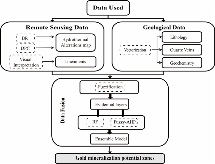
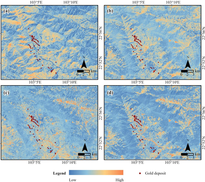
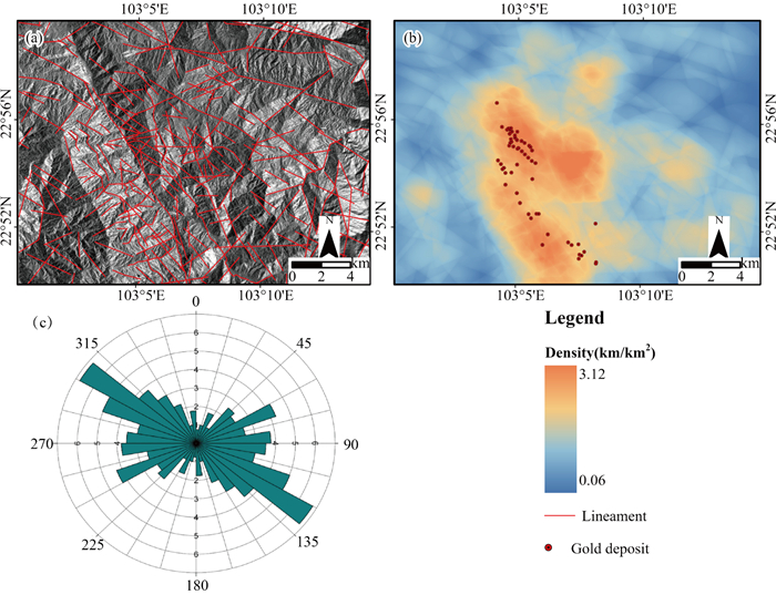
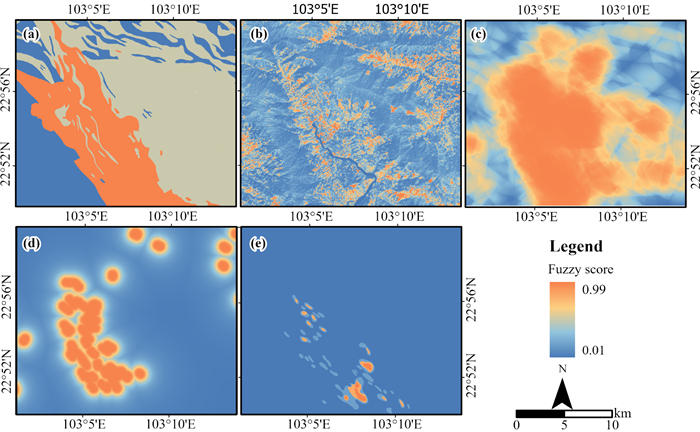
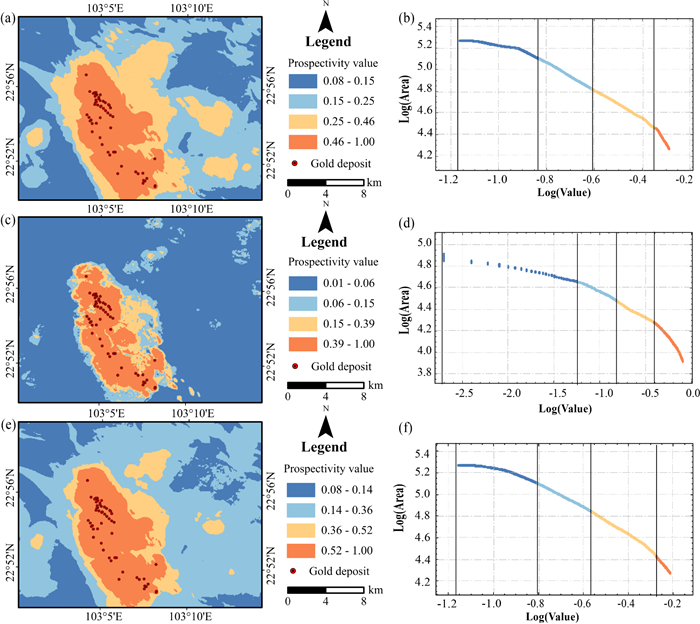
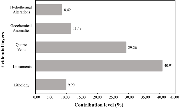
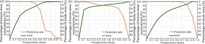
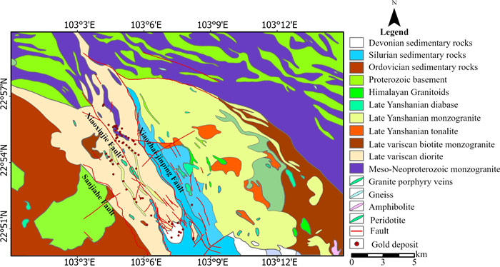
Analyzing and integrating evidential layers is essential for mineral prospectivity mapping. Remote sensing data from Landsat 8 and PALSAR-2/ALOS-2 were used to extract information about hydrothermal alterations and lineaments in a vegetation-covered study area. After integrating geological data, five evidential layers were identified, associated with gold mineralization, including lithology, hydrothermal alterations, lineaments, quartz veins, and geochemical anomalies. Based on these layers, prospective maps for mineralization were generated using RF and Fuzzy AHP models, as well as their ensemble. The P-A plot was used to evaluate the capability of model prediction. The results indicated that the three models yielded similar predictions, with areas of high mineralization potential located in the central part of the Daping area. The ensemble model demonstrated superior predictive performance.

| Abedi, M., Torabi, S., Norouzi, G., 2013. Application of Fuzzy AHP Method to Integrate Geophysical Data in a Prospect Scale, a Case Study: Seridune Copper Deposit. Bollettino di Geofisica Teorica ed Applicata, 54(2): 145–164. https://doi.org/10.4430/bgta0085 |
| Agterberg, F., Bonham-Carter, G., 1999. Logistic Regression and Weights of Evidence Modeling in Mineral Exploration, In: Proceedings of the 28th International Symposium on Applications of Computer in the Mineral Industry (APCOM), Golden, Colorado |
| An, W. T., Chen, J. P., Li, Y. C., et al., 2021. The Superposition Characteristics of Primary Halo in the Daping Gold Deposit, Yunnan Province, China and Its Significance for Exploration. Journal of Geochemical Exploration, 228: 106809. https://doi.org/10.1016/j.gexplo.2021.106809 |
| Bai, H. Y., Cao, Y., Zhang, H., et al., 2021. Combining Fuzzy Analytic Hierarchy Process with Concentration-Area Fractal for Mineral Prospectivity Mapping: A Case Study Involving Qinling Orogenic Belt in Central China. Applied Geochemistry, 126: 104894. https://doi.org/10.1016/j.apgeochem.2021.104894 |
| Bonham-Carter, G., 1994. Preface. Geographic Information Systems for Geoscientists. Elsevier, Amsterdam. https://doi.org/10.1016/b978-0-08-041867-4.50005-9 |
| Breiman, L., 2001. Random Forests. Machine Learning, 45(1): 5–32. https://doi.org/10.1023/a:1010933404324 |
| Carranza, E. J. M., Hale, M., 2002. Mineral Imaging with Landsat Thematic Mapper Data for Hydrothermal Alteration Mapping in Heavily Vegetated Terrane. International Journal of Remote Sensing, 23(22): 4827–4852. https://doi.org/10.1080/014311601 10115014 doi: 10.1080/01431160110115014 |
| Carranza, E. J. M., Hale, M., 2003. Evidential Belief Functions for Data-Driven Geologically Constrained Mapping of Gold Potential, Baguio District, Philippines. Ore Geology Reviews, 22(1/2): 117–132. https://doi.org/10.1016/s0169-1368(02)00111-7 |
| Carranza, E. J. M., Mangaoang, J. C., Hale, M., 1999. Application of Mineral Exploration Models and GIS to Generate Mineral Potential Maps as Input for Optimum Land-Use Planning in the Philippines. Natural Resources Research, 8(2): 165–173. https://doi.org/10.1023/a:1021846820568 |
| Carranza, E. J. M., van Ruitenbeek, F. J. A., Hecker, C., et al., 2008. Knowledge-Guided Data-Driven Evidential Belief Modeling of Mineral Prospectivity in Cabo de Gata, SE Spain. International Journal of Applied Earth Observation and Geoinformation, 10(3): 374–387. https://doi.org/10.1016/j.jag.2008.02.008 |
| Chen, Y. H., Yao, S. Z., Pan, Y. M., 2014. Geochemistry of Lamprophyres at the Daping Gold Deposit, Yunnan Province, China: Constraints on the Timing of Gold Mineralization and Evidence for Mantle Convection in the Eastern Tibetan Plateau. Journal of Asian Earth Sciences, 93: 129–145. https://doi.org/10.1016/j.jseaes.2014.07.033 |
| Cheng, G., Ban, Y. Y., Deng, X. Q., et al., 2023. Research on Quan-titative Inversion of Ion Adsorption Type Rare Earth Ore Based on Convolutional Neural Network. Frontiers in Earth Science, 10: 1086325. https://doi.org/10.3389/feart.2022.1086325 |
| Cheng, G., Huang, H. K., Li, H., et al., 2021. Quantitative Remote Sensing of Metallic Elements for the Qishitan Gold Polymetallic Mining Area, NW China. Remote Sensing, 13(13): 2519. https://doi.org/10.3390/rs13132519 |
| Cheng, G., Zhang, H. R., Li, H., et al., 2023. Quantitative Inversion of REEs in Ion-Adsorbed Rare Earth Ores from the Liutang Area (South China), Based on Measured Hyperspectral Data. Journal of Earth Science, 34(4): 1068–1082. https://doi.org/10.1007/s12 583-021-1504-1 doi: 10.1007/s12583-021-1504-1 |
| Cheng, Q. M., Agterberg, F. P., Ballantyne, S. B., 1994. The Separation of Geochemical Anomalies from Background by Fractal Methods. Journal of Geochemical Exploration, 51(2): 109–130. https://doi.org/10.1016/0375-6742(94)90013-2 |
| Daviran, M., Parsa, M., Maghsoudi, A., et al., 2022. Quantifying Uncertainties Linked to the Diversity of Mathematical Frameworks in Knowledge-Driven Mineral Prospectivity Mapping. Natural Resources Research, 31(5): 2271–2287. https://doi.org/10.1007/s11053-022-10089-w |
| Del Pilar Villalta Echeverria, M., Viña Ortega, A. G., Larreta, E., et al., 2022. Lineament Extraction from Digital Terrain Derivate Model: A Case Study in the Girón-Santa Isabel Basin, South Ecuador. Remote Sensing, 14(21): 5400. https://doi.org/10.3390/rs14215400 |
| Du, X., Zhou, K. F., Cui, Y., et al., 2016. Application of Fuzzy Analytical Hierarchy Process (AHP) and Prediction-Area (P-a) Plot for Mineral Prospectivity Mapping: A Case Study from the Dananhu Metallogenic Belt, Xinjiang, NW China. Arabian Journal of Geosciences, 9(4): 298. https://doi.org/10.1007/s125 17-016-2316-y doi: 10.1007/s12517-016-2316-y |
| Feizi, F., Karbalaei-Ramezanali, A., Tusi, H., 2017. Mineral Potential Mapping via TOPSIS with Hybrid AHP-Shannon Entropy Weighting of Evidence: A Case Study for Porphyry-Cu, Farmahin Area, Markazi Province, Iran. Natural Resources Research, 26(4): 553–570. https://doi.org/10.1007/s11053-017-9338-3 |
| Fraser, S. J., Green, A. A., 1987. A Software Defoliant for Geological Analysis of Band Ratios. International Journal of Remote Sensing, 8(3): 525–532. https://doi.org/10.1080/014311687089 48659 doi: 10.1080/01431168708948659 |
| Ghezelbash, R., Maghsoudi, A., 2018. A Hybrid AHP-VIKOR Approach for Prospectivity Modeling of Porphyry Cu Deposits in the Varzaghan District, NW Iran. Arabian Journal of Geosciences, 11(11): 275. https://doi.org/10.1007/s12517-018-3624-1 |
| Hashim, M., Ahmad, S., Johari, M. A. M., et al., 2013. Automatic Lineament Extraction in a Heavily Vegetated Region Using Landsat Enhanced Thematic Mapper (ETM+) Imagery. Advances in Space Research, 51(5): 874–890. https://doi.org/10.1016/j.asr.2012.10.004 |
| Khosravi, V., Shirazi, A., Shirazy, A., et al., 2022. Hybrid Fuzzy-Analytic Hierarchy Process (AHP) Model for Porphyry Copper Prospecting in Simorgh Area, Eastern Lut Block of Iran. Mining, 2(1): 1–12. https://doi.org/10.3390/mining2010001 |
| Li, T. F., Xia, Q. L., Zhao, M. Y., et al., 2020. Prospectivity Mapping for Tungsten Polymetallic Mineral Resources, Nanling Metallogenic Belt, South China: Use of Random Forest Algorithm from a Perspective of Data Imbalance. Natural Resources Research, 29(1): 203–227. https://doi.org/10.1007/s11053-019-09564-8 |
| Liaw, A., Wiener, M., 2002. Classification and Regression by Randomforest. R News, 2(3): 18–22 |
| Lisitsin, V. A., Porwal, A., McCuaig, T. C., 2014. Probabilistic Fuzzy Logic Modeling: Quantifying Uncertainty of Mineral Prospectivity Models Using Monte Carlo Simulations. Mathematical Geosciences, 46(6): 747–769. https://doi.org/10.1007/s11004-014-9534-1 |
| Liu, F., Wu, X., Sun, H., et al., 2007. Alteration Information Extraction by Applying Synthesis Processing Techniques to Landsat ETM+ Data: Case Study of Zhaoyuan Gold Mines, Shandong Province, China. Journal of China University of Geosciences, 18(1): 72–76. https://doi.org/10.1016/s1002-0705(07)60020-x |
| Liu, W., Cui, W. L., Chen, M. J., et al., 2023. Operation Safety Risk Assessment of Water Distribution Networks Based on the Combined Weighting Method (CWM). KSCE Journal of Civil Engineering, 27(5): 2116–2130. https://doi.org/10.1007/s12205-023-1552-4 |
| Mohamed Taha, A. M., Xi, Y. T., He, Q. P., et al., 2023. Investigating the Capabilities of Various Multispectral Remote Sensors Data to Map Mineral Prospectivity Based on Random Forest Predictive Model: A Case Study for Gold Deposits in Hamissana Area, NE Sudan. Minerals, 13(1): 49. https://doi.org/10.3390/min13010049 |
| Moon, W. M., An, P., 1991. Integration of Geophysical, Geological and Remote Sensing Data Using Fuzzy Set Theory. Geoinformatics, 2(2): 171–176. https://doi.org/10.6010/geoinfor matics1990.2.2_171 doi: 10.6010/geoinformatics1990.2.2_171 |
| Najafi, A., Karimpour, M. H., Ghaderi, M., 2014. Application of Fuzzy AHP Method to IOCG Prospectivity Mapping: A Case Study in Taherabad Prospecting Area, Eastern Iran. International Journal of Applied Earth Observation and Geoinformation, 33: 142–154. https://doi.org/10.1016/j.jag.2014.05.003 |
| Nykänen, V., Salmirinne, H., 2007. Prospectivity Analysis of Gold Using Regional Geophysical and Geochemical Data from the Central Lapland Greenstone Belt, Finland. Geological Survey of Finland, 44: 251–269 |
| Opitz, D., Maclin, R., 1999. Popular Ensemble Methods: An Empirical Study. Journal of Artificial Intelligence Research, 11: 169–198. https://doi.org/10.1613/jair.614 |
| Parsa, M., Maghsoudi, A., Yousefi, M., 2018. Spatial Analyses of Exploration Evidence Data to Model Skarn-Type Copper Prospectivity in the Varzaghan District, NW Iran. Ore Geology Reviews, 92: 97–112. https://doi.org/10.1016/j.oregeorev.201 7.11.013 doi: 10.1016/j.oregeorev.2017.11.013 |
| Pour, A. B., Hashim, M., Hong, J. K., et al., 2019. Lithological and Alteration Mineral Mapping in Poorly Exposed Lithologies Using Landsat-8 and ASTER Satellite Data: North-Eastern Graham Land, Antarctic Peninsula. Ore Geology Reviews, 108: 112–133. https://doi.org/10.1016/j.oregeorev.2017.07.018 |
| Pour, A. B., Hashim, M., van Genderen, J., 2013. Detection of Hydrothermal Alteration Zones in a Tropical Region Using Satellite Remote Sensing Data: Bau Goldfield, Sarawak, Malaysia. Ore Geology Reviews, 54: 181–196. https://doi.org/10.1016/j.oregeorev.2013.03.010 |
| Pour, A. B., Park, Y., Park, T. S., et al., 2018. Regional Geology Mapping Using Satellite-Based Remote Sensing Approach in Northern Victoria Land, Antarctica. Polar Science, 16: 23–46. https://doi.org/10.1016/j.polar.2018.02.004 |
| Qiao, L., Ren, P., 2021. Human-Caused Risk Assessment of Community Indoor Gas Based on RF-AHP. Industrial Control Computer, 34(4): 70–74 (in Chinese with English Abstract) |
| Ruiz-Armenta, J. R., Prol-Ledesma, R. M., 1998. Techniques for Enhancing the Spectral Response of Hydrothermal Alteration Minerals in Thematic Mapper Images of Central Mexico. International Journal of Remote Sensing, 19(10): 1981–2000. https://doi.org/10.1080/014311698215108 |
| Shabani, A., Ziaii, M., Monfared, M., et al., 2022. Multi-Dimensional Data Fusion for Mineral Prospectivity Mapping (MPM) Using Fuzzy-AHP Decision-Making Method, Kodegan-Basiran Region, East Iran. Minerals, 12(12): 1629. https://doi.org/10.3390/min12 121629 doi: 10.3390/min12121629 |
| Sheikhrahimi, A., Pour, A. B., Pradhan, B., et al., 2019. Mapping Hydrothermal Alteration Zones and Lineaments Associated with Orogenic Gold Mineralization Using ASTER Data: A Case Study from the Sanandaj-Sirjan Zone, Iran. Advances in Space Research, 63(10): 3315–3332. https://doi.org/10.1016/j.asr.201 9.01.035 doi: 10.1016/j.asr.2019.01.035 |
| Shirazi, A., Hezarkhani, A., Beiranvand Pour, A., et al., 2022. Neuro-Fuzzy-AHP (NFAHP) Technique for Copper Exploration Using Advanced Spaceborne Thermal Emission and Reflection Radiometer (ASTER) and Geological Datasets in the Sahlabad Mining Area, East Iran. Remote Sensing, 14(21): 5562. https://doi.org/10.3390/rs14215562 |
| Shirazi, A., Hezarkhani, A., Pour, A. B., 2022. Fusion of Lineament Factor (LF) Map Analysis and Multifractal Technique for Massive Sulfide Copper Exploration: The Sahlabad Area, East Iran. Minerals, 12(5): 549. https://doi.org/10.3390/min12050549 |
| Singer, D. A., Kouda, R., 1996. Application of a Feedforward Neural Network in the Search for Kuroko Deposits in the Hokuroku District, Japan. Mathematical Geology, 28(8): 1017–1023. https://doi.org/10.1007/bf0206858 |
| Song, G., Yang, D. L., 2004. Combination Weighting Approach Based on the Decision-Maker's Preference and Consistency of Weighting Methods. Systems Engineering and Electronics, 26(9): 1226–1230 (in Chinese with English Abstract) |
| Sun, T., Chen, F., Zhong, L. X., et al., 2019. GIS-Based Mineral Prospectivity Mapping Using Machine Learning Methods: A Case Study from Tongling Ore District, Eastern China. Ore Geology Reviews, 109: 26–49.https://doi.org/10.1016/j.oregeor ev.2019.04.003 doi: 10.1016/j.oregeorev.2019.04.003 |
| Takodjou Wambo, J. D., Pour, A. B., Ganno, S., et al., 2020. Identifying High Potential Zones of Gold Mineralization in a Sub-Tropical Region Using Landsat-8 and ASTER Remote Sensing Data: A Case Study of the Ngoura-Colomines Goldfield, Eastern Cameroon. Ore Geology Reviews, 122: 103530. https://doi.org/10.1016/j.oregeorev.2020.103530 |
| Thanh, N. N., Chotpantarat, S., Trung, N. H., et al., 2022. Mapping Groundwater Potential Zones in Kanchanaburi Province, Thailand by Integrating of Analytic Hierarchy Process, Frequency Ratio, and Random Forest. Ecological Indicators, 145: 109591. https://doi.org/10.1016/j.ecolind.2022.109591 |
| Tripathi, M. K., Govil, H., Bhaumik, P., 2022. Implications and Interrelations of Litho-Boundaries and Vicinity of Lineaments for Hydrothermal Alteration Zones under Remote Sensing and GIS Environment. Advances in Space Research, 70(3): 621–640. https://doi.org/10.1016/j.asr.2022.05.019 |
| Xiao, K. Y., Xiang, J., Fan, M. J., et al., 2021.3D Mineral Prospectivity Mapping Based on Deep Metallogenic Prediction Theory: A Case Study of the Lala Copper Mine, Sichuan, China. Journal of Earth Science, 32(2): 348–357.https://doi.org/10.10 07/s12583-021-1437-8 doi: 10.1007/s12583-021-1437-8 |
| Yousefi, M., Carranza, E. J. M., 2015. Fuzzification of Continuous-Value Spatial Evidence for Mineral Prospectivity Mapping. Computers & Geosciences, 74: 97–109. https://doi.org/10.1016/j.cageo.2014.10.014 |
| Yousefi, M., Carranza, E. J. M., 2016. Data-Driven Index Overlay and Boolean Logic Mineral Prospectivity Modeling in Greenfields Exploration. Natural Resources Research, 25(1): 3–18. https://doi.org/10.1007/s11053-014-9261-9 |
| Yousefi, M., Nykänen, V., 2016. Data-Driven Logistic-Based Weighting of Geochemical and Geological Evidence Layers in Mineral Prospectivity Mapping. Journal of Geochemical Exploration, 164: 94–106.https://doi.org/10.1016/j.gexplo.201 5.10.008 doi: 10.1016/j.gexplo.2015.10.008 |
| Zuo, R. G., Kreuzer, O. P., Wang, J., et al., 2021. Uncertainties in GIS-Based Mineral Prospectivity Mapping: Key Types, Potential Impacts and Possible Solutions. Natural Resources Research, 30(5): 3059–3079. https://doi.org/10.1007/s11053-021-09871-z |
Figures(8) / Tables(3)
Copyright © 2013-2020 Journal of Earth Science 鄂ICP备15021562号-2
Tel: +86-27-67885075 Fax: +86-27-67885075 E-mail: xbb@cug.edu.cn
Address: Editorial Office of Journal, China University of Geosciences, Yujiashan, Wuhan, Hubei 430074, P. R. China
Supported by:
Beijing Renhe Information Technology Co. Ltd
E-mail:
info@rhhz.net


 DownLoad: