| Citation: | Fabio Ietto, Massimo Conforti, Cristiano Tolomei, Federico Cella, Giuseppe Cianflone. Assessment of Slow Deformations and Landslide Modelling in the Urban Area through a Multi-Methodological Approach. Journal of Earth Science, 2025, 36(2): 717-736. doi: 10.1007/s12583-024-0056-6

|
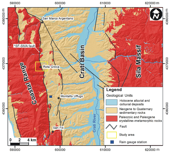
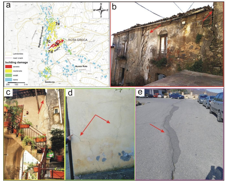
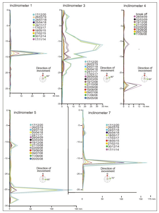
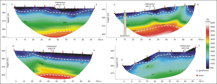
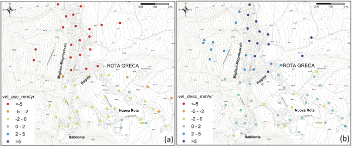
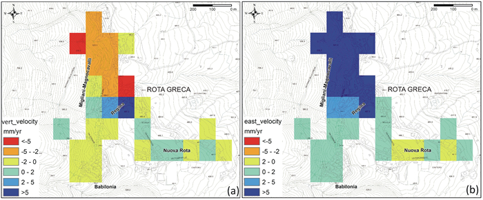
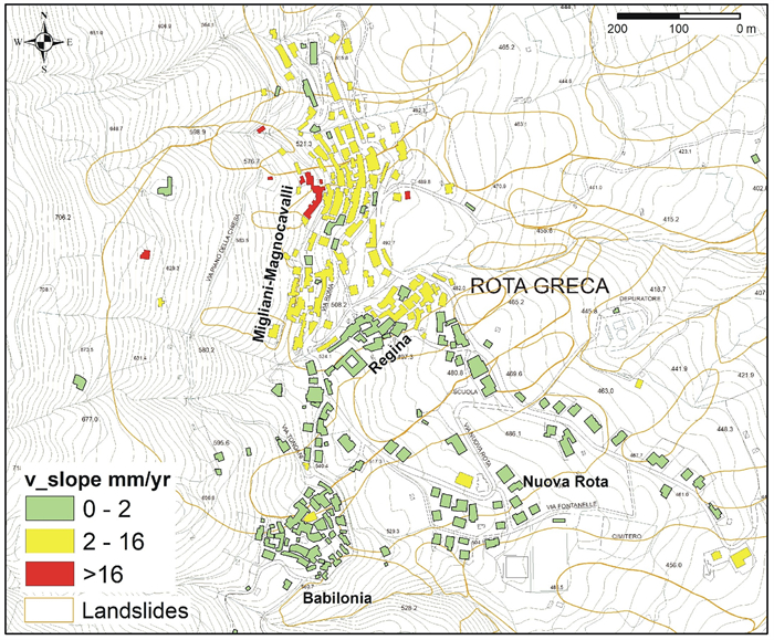
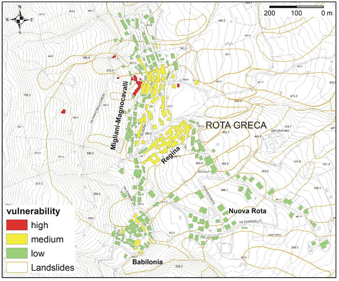
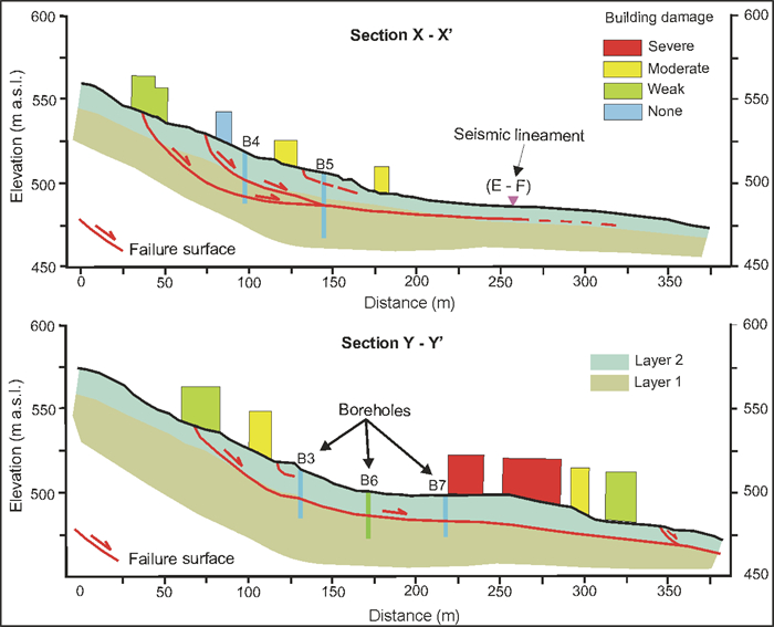
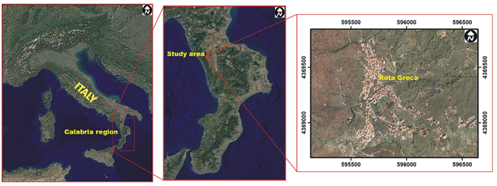
Slow-moving landslides are widespread in the Mediterranean area, causing damage to the exposed facilities and economic losses in many countries. The recognition of slow-moving landslides in urban areas is always a difficult task to deal with because the presence of buildings, infrastructures, and human activities usually conceals the morphological signs of these landslide activities. So, in the last decades, numerous researchers have shown new methodologies to deepen the studies of similar instability phenomena. The present research is based on an integrated approach to investigate the landslide boundaries, type of movement, failure surface depth, and vulnerability state of buildings in Rota Greca Village (Calabria region, southern Italy) affected by a slow-moving landslide. For this purpose, multi-source data were acquired through geological and geomorphological surveys, recognition of landslide-induced damage on the built environment, subsurface investigations (e.g., continuous drill boreholes, Standard Penetration Test, Rock Quality Designation index and inclinometer monitoring), laboratory tests (direct shear tests on undisturbed samples), geophysical survey, and InSAR-derived map of deformation rates. The complete integration of multi-source data allowed for the construction of reliable landslide modelling with relative geotechnical properties. In addition, the cross-comparison between surface deformation data by SAR images and severity damage level collected on the exposed buildings enabled to obtain the vulnerability map of the built area. In particular, the achieved goals highlighted two failure surfaces at about -13 and -25 m depth, causing a high vulnerability value for the buildings allocated in the central portion of the Rota Greca Village. The knowledge acquired by the multi-approach can be used to manage and implement appropriate landslide risk mitigation strategies, providing helpful advice and best practices to state-run organisations and stakeholders for landslide management in urban sites.

| Antonioli, F., Ferranti, L., Lambeck, K., et al., 2006. Late Pleistocene to Holocene Record of Changing Uplift Rates in Southern Calabria and Northeastern Sicily (Southern Italy, Central Mediterranean Sea). Tectonophysics, 422(1/2/3/4): 23–40. https://doi.org/10.1016/j.tecto.2006.05.003 |
| Antronico, L., Borrelli, L., Coscarelli, R., 2017. Recent Damaging Events on Alluvial Fans along a Stretch of the Tyrrhenian Coast of Calabria (Southern Italy). Bulletin of Engineering Geology and the Environment, 76(4): 1399–1416. https://doi.org/10.1007/s10064-016-0922-2 |
| Antronico, L., de Pascale, F., Coscarelli, R., et al., 2020. Landslide Risk Perception, Social Vulnerability and Community Resilience: The Case Study of Maierato (Calabria, Southern Italy). International Journal of Disaster Risk Reduction, 46: 101529. https://doi.org/10.1016/j.ijdrr.2020.101529 |
|
ASICal Database, 2022. Historical Information on Landslides and Floods in Calabria. Available at |
| ASTM International Standard, 2011. Standard Test Method for Direct Shear Test of Soils Under Consolidated Drained Conditions. ASTM Stand D3080M |
| ASTM International Standard, 2017. Standard Guide for Using the Seismic Refraction Method for Subsurface Investigation. ASTM Stand D5777 |
| ASTM International Standard, 2017. Standard Test Method for Determining Rock Quality Designation (RQD) of Rock Core. ASTM Stand D6032 |
| ASTM International Standard, 2018. Standard Test Method for Standard Penetration Test (SPT) and Split-Barrel Sampling of Soils. ASTM Stand D1586M |
| Barberi, G., Cosentino, M. T., Gervasi, A., et al., 2004. Crustal Seismic Tomography in the Calabrian Arc Region, South Italy. Physics of the Earth and Planetary Interiors, 147(4): 297–314. https://doi.org/10.1016/j.pepi.2004.04.005 |
| Bardi, F., Frodella, W., Ciampalini, A., et al., 2014. Integration between Ground Based and Satellite SAR Data in Landslide Mapping: The San Fratello Case Study. Geomorphology, 223: 45–60. https://doi.org/10.1016/j.geomorph.2014.06.025 |
| Barjasteh, A., 2019. The Impact of Active Faulting on the Geotechnical Properties of the Upper Gotvand Dam, Southwest Iran. Bulletin of Engineering Geology and the Environment, 78(2): 709–722. https://doi.org/10.1007/s10064-017-1163-8 |
| Béjar-Pizarro, M., Notti, D., Mateos, R. M., et al., 2017. Mapping Vulnerable Urban Areas Affected by Slow-Moving Landslides Using Sentinel-1 InSAR Data. Remote Sensing, 9(9): 876. https://doi.org/10.3390/rs9090876 |
| Ben Avraham, Z., Boccaletti, M., Cello, G., et al., 1990. Principali Domini Strutturali Originatisi Dalla Collisione Neogenico–Quaternaria nel Mediterraneo Centrale. Memorie Società Geologica Italiana, 45: 453–462 (in Italian) |
| Borrelli, L., Gullà, G., 2017. Tectonic Constraints on a Deep-Seated Rock Slide in Weathered Crystalline Rocks. Geomorphology, 290: 288–316. https://doi.org/10.1016/j.geomorph.2017.04.025 |
| Brozzetti, F., Cirillo, D., Liberi, F., et al., 2017. Structural Style of Quaternary Extension in the Crati Valley (Calabrian Arc): Evidence in Support of an East-Dipping Detachment Fault. Italian Journal of Geosciences, 136(3): 434–453. https://doi.org/10.3301/ijg.2017.11 |
|
Brunori, C. A., Bignami, C., Zucca, F., et al., 2014. Ground Fracturation in Urban Area: Monitoring of Land Subsidence Controlled by Buried Faults with InSAR Techniques (Ciudad Guzmán: Mexico). Engineering Geology for Society and Territory-Volume 5. Springer International Publishing, Cham. |
| Calcaterra, D., Parise, M., 2010. Weathering as a Predisposing Factor to Slope Movements: An Introduction. Geological Society Engineering Geology Special Publication, 23: 105–130 |
| Caloiero, T., Buttafuoco, G., Coscarelli, R., et al., 2015. Spatial and Temporal Characterization of Climate at Regional Scale Using Homogeneous Monthly Precipitation and Air Temperature Data: an Application in Calabria (Southern Italy). Hydrology Research, 46(4): 629–646. https://doi.org/10.2166/nh.2014.022 |
| Capparelli, G., Iaquinta, P., Iovine, G. G. R., et al., 2012. Modelling the Rainfall-Induced Mobilization of a Large Slope Movement in Northern Calabria. Natural Hazards, 61(1): 247–256. https://doi.org/10.1007/s11069-010-9651-1 |
| Carrara, A., Merenda, L., 1976. Landslide Inventory in Northern Calabria, Southern Italy. Geological Society of America Bulletin, 87(8): 1153–1162. https://doi.org/10.1130/0016-7606(1976)871153:liincs>2.0.co;2 doi: 10.1130/0016-7606(1976)871153:liincs>2.0.co;2 |
| Casagli, N., Colombo, D., Corazza, A., et al., 2006, Use of Remote Sensing Data for Supporting Landslide Risk Management: Case History of Cavallerizzo, Cosenza Province, Southern Italy. Geophysical Research Abstracts, 8: 6087 |
| Cascini, L., Peduto, D., Pisciotta, G., et al., 2013. The Combination of DInSAR and Facility Damage Data for the Updating of Slow-Moving Landslide Inventory Maps at Medium Scale. Natural Hazards and Earth System Sciences, 13(6): 1527–1549. https://doi.org/10.5194/nhess-13-1527-2013 |
| Chen, T. H. K., Prishchepov, A. V., Fensholt, R., et al., 2019. Detecting and Monitoring Long-Term Landslides in Urbanized Areas with Nighttime Light Data and Multi-Seasonal Landsat Imagery across Taiwan from 1998 to 2017. Remote Sensing of Environment, 225: 317–327. https://doi.org/10.1016/j.rse.2019.03.013 |
| Cianflone, G., Conforti, M., Soleri, S., et al., 2021. Preliminary Data on Slow-Moving Landslides-Affected Urban Areas through Geological, Geomorphological and Insar Analysis. Italian Journal of Engineering Geology and Environment, 1: 21–33 |
| Cianflone, G., Tolomei, C., Brunori, C., et al., 2018. Landslides and Subsidence Assessment in the Crati Valley (Southern Italy) Using InSAR Data. Geosciences, 8(2): 67. https://doi.org/10.3390/geosciences8020067 |
| Cigna, F., Bianchini, S., Casagli, N., 2013. How to Assess Landslide Activity and Intensity with Persistent Scatterer Interferometry (PSI): The PSI-Based Matrix Approach. Landslides, 10(3): 267–283. https://doi.org/10.1007/s10346-012-0335-7 |
|
Cigna, F., Confuorto, P., Novellino, A., et al., 2016. 25 Years of Satellite InSAR Monitoring of Ground Instability and Coastal Geohazards in the Archaeological Site of Capo Colonna, ItalySPIE Proceedings, SAR Image Analysis, Modeling, and Techniques XVI. Edinburgh, United Kingdom. SPIE, |
| Cirillo, D., Zappa, M., Tangari, A. C., et al., 2024. Rockfall Analysis from UAV-Based Photogrammetry and 3D Models of a Cliff Area. Drones, 8(1): 31. https://doi.org/10.3390/drones8010031 |
| Colella, A., de Boer, P. L., Nio, S. D., 1987. Sedimentology of a Marine Intermontane Pleistocene Gilbert-Type Fan-Delta Complex in the Crati Basin, Calabria, Southern Italy. Sedimentology, 34(4): 721–736. https://doi.org/10.1111/j.1365-3091.1987.tb00798.x |
| Conforti, M., Borrelli, L., Cofone, G., et al., 2023. Exploring Performance and Robustness of Shallow Landslide Susceptibility Modeling at Regional Scale Using Different Training and Testing Sets. Environmental Earth Sciences, 82(7): 161. https://doi.org/10.1007/s12665-023-10844-z |
| Conforti, M., Buttafuoco, G., 2017. Assessing Space-Time Variations of Denudation Processes and Related Soil Loss from 1955 to 2016 in Southern Italy (Calabria Region). Environmental Earth Sciences, 76(13): 457. https://doi.org/10.1007/s12665-017-6786-3 |
| Conforti, M., Ietto, F., 2019. An Integrated Approach to Investigate Slope Instability Affecting Infrastructures. Bulletin of Engineering Geology and the Environment, 78(4): 2355–2375. https://doi.org/10.1007/s10064-018-1311-9 |
| Conforti, M., Ietto, F., 2020. Influence of Tectonics and Morphometric Features on the Landslide Distribution: A Case Study from the Mesima Basin (Calabria, South Italy). Journal of Earth Science, 31(2): 393–409. https://doi.org/10.1007/s12583-019-1231-z |
| Conforti, M., Ietto, F., 2021. Modeling Shallow Landslide Susceptibility and Assessment of the Relative Importance of Predisposing Factors, through a GIS-Based Statistical Analysis. Geosciences, 11(8): 333. https://doi.org/10.3390/geosciences11080333 |
| Conforti, M., Pascale, S., Robustelli, G., et al., 2014. Evaluation of Prediction Capability of the Artificial Neural Networks for Mapping Landslide Susceptibility in the Turbolo River Catchment (Northern Calabria, Italy). CATENA, 113: 236–250. https://doi.org/10.1016/j.catena.2013.08.006 |
| Confuorto, P., Di Martire, D., Infante, D., et al., 2019. Monitoring of Remedial Works Performance on Landslide-Affected Areas through Ground- and Satellite-Based Techniques. CATENA, 178: 77–89. https://doi.org/10.1016/j.catena.2019.03.005 |
| Cook, M. E., Brook, M. S., Hamling, I. J., et al., 2022. Engineering Geomorphological and InSAR Investigation of an Urban Landslide, Gisborne, New Zealand. Landslides, 19(10): 2423–2437. https://doi.org/10.1007/s10346-022-01938-z |
| Cruden, D. M., Varnes, D. J., 1996. Landslide Types and Processes. In: Turner, A. K., Schuster, R. L., eds., Landslides: Investigation and Mitigation. National Academy Press, Washington D. C. |
| Cucci, L., Tertulliani, A., 2006. I Terrazzi Marini Nell'Area di Capo Vaticano (Arco Calabro): Solo un Record di Sollevamento Regionale o Anche di Deformazione Cosismica? Il Quaternario, 19: 89–101 |
| Dalla Via, G., Crosetto, M., Crippa, B., 2012. Resolving Vertical and East-West Horizontal Motion from Differential Interferometric Synthetic Aperture Radar: The L'Aquila Earthquake. Journal of Geophysical Research: Solid Earth, 117(B2): B02310. https://doi.org/10.1029/2011jb008689 |
|
Deere, D. U., Deere, D. W., 1988. The Rock Quality Designation (RQD) Index in Practice. Rock Classification Systems for Engineering Purposes. ASTM International100 Barr Harbor Drive, PO Box C700, West Conshohocken, PA 19428-2959: 91–101. |
| Del Soldato, M., Bianchini, S., Calcaterra, D., et al., 2017. A New Approach for Landslide-Induced Damage Assessment. Geomatics, Natural Hazards and Risk, 8(2): 1524–1537. https://doi.org/10.1080/19475705.2017.1347896 |
|
Del Soldato, M., Bianchini, S., de Vita, P., et al., 2020. Relation between On-Field and InSAR Data on Landslide-Induced Damage. Applied Geology. Springer International Publishing, Cham. |
| Di Martire, D., Novellino, A., Ramondini, M., et al., 2016. A-Differential Synthetic Aperture Radar Interferometry Analysis of a Deep Seated Gravitational Slope Deformation Occurring at Bisaccia (Italy). Science of the Total Environment, 550: 556–573. https://doi.org/10.1016/j.scitotenv.2016.01.102 |
| Dramis, F., Sorriso-Valvo, M., 1994. Deep-Seated Gravitational Slope Deformations, Related Landslides and Tectonics. Engineering Geology, 38(3/4): 231–243. https://doi.org/10.1016/0013-7952(94)90040-x |
| Ferlisi, S., Gullà, G., Nicodemo, G., et al., 2019. A Multi-Scale Methodological Approach for Slow-Moving Landslide Risk Mitigation in Urban Areas, Southern Italy. Euro-Mediterranean Journal for Environmental Integration, 4(1): 20. https://doi.org/10.1007/s41207-019-0110-4 |
| Ferretti, A., Prati, C., Rocca, F., 2001. Permanent Scatterers in SAR Interferometry. IEEE Transactions on Geoscience and Remote Sensing, 39(1): 8–20. https://doi.org/10.1109/36.898661 |
| Filice, F., Liberi, F., Cirillo, D., et al., 2015. Geology Map of the Central Area of Catena Costiera: Insights into the Tectono-Metamorphic Evolution of the Alpine Belt in Northern Calabria. Journal of Maps, 11(1): 114–125. https://doi.org/10.1080/17445647.2014.944877 |
| Filice, F., Pezzo, A., Lollino, P., et al., 2022. Multi-Approach for the Assessment of Rock Slope Stability Using In-Field and UAV Investigations. Bulletin of Engineering Geology and the Environment, 81(12): 502. https://doi.org/10.1007/s10064-022-03007-0 |
|
Foumelis, M., Blasco, J. M. D., Brito, F., et al., 2021. Snapping for Sentinel-1 Mission on Geohazards Exploitation Platform: An Online Medium Resolution Surface Motion Mapping Service2021 IEEE International Geoscience and Remote Sensing Symposium IGARSS, July 11–16, 2021, Brussels, IEEE. |
| Gariano, S. L., Guzzetti, F., 2016. Landslides in a Changing Climate. Earth-Science Reviews, 162: 227–252. https://doi.org/10.1016/j.earscirev.2016.08.011 |
| Gariano, S. L., Rianna, G., Petrucci, O., et al., 2017. Assessing Future Changes in the Occurrence of Rainfall-Induced Landslides at a Regional Scale. The Science of the Total Environment, 596/597: 417–426. https://doi.org/10.1016/j.scitotenv.2017.03.103 |
| Gattinoni, P., 2009. Parametrical Landslide Modeling for the Hydrogeological Susceptibility Assessment: From the Crati Valley to the Cavallerizzo Landslide (Southern Italy). Natural Hazards, 50(1): 161–178. https://doi.org/10.1007/s11069-008-9328-1 |
| Guerriero, L., Confuorto, P., Calcaterra, D., et al., 2019. PS-Driven Inventory of Town-Damaging Landslides in the Benevento, Avellino and Salerno Provinces, Southern Italy. Journal of Maps, 15(2): 619–625. https://doi.org/10.1080/17445647.2019.1651770 |
| Guerriero, L., Prinzi, E. P., Calcaterra, D., et al., 2021. Kinematics and Geologic Control of the Deep-Seated Landslide Affecting the Historic Center of Buonalbergo, Southern Italy. Geomorphology, 394: 107961. https://doi.org/10.1016/j.geomorph.2021.107961 |
| Gullà, G., Conforti, M., Borrelli, L., 2021. A Refinement Analysis of the Shallow Landslides Susceptibility at Regional Scale Supported by GIS-Aided Geo-Database. Geomatics, Natural Hazards and Risk, 12(1): 2500–2543. https://doi.org/10.1080/19475705.2021.1967204 |
| Guzzetti, F., Stark, C. P., Salvati, P., 2005. Evaluation of Flood and Landslide Risk to the Population of Italy. Environmental Management, 36(1): 15–36. https://doi.org/10.1007/s00267-003-0257-1 |
| Gvirtzman, Z., Nur, A., 1999. Plate Detachment, Asthenosphere Upwelling, and Topography across Subduction Zones. Geology, 27(6): 563–566. https://doi.org/10.1130/0091-7613(1999)0270563:pdauat>2.3.co;2 doi: 10.1130/0091-7613(1999)0270563:pdauat>2.3.co;2 |
| Haque, U., Blum, P., da Silva, P. F., et al., 2016. Fatal Landslides in Europe. Landslides, 13(6): 1545–1554. https://doi.org/10.1007/s10346-016-0689-3 |
| Hooper, A., 2008. A Multi-Temporal InSAR Method Incorporating both Persistent Scatterer and Small Baseline Approaches. Geophysical Research Letters, 35(16): L16302. https://doi.org/10.1029/2008gl034654 |
| Hungr, O., Leroueil, S., Picarelli, L., 2014. The Varnes Classification of Landslide Types, an Update. Landslides, 11(2): 167–194. https://doi.org/10.1007/s10346-013-0436-y |
| Ietto, F., Bernasconi, M. P., 2005. The Cliff Bordering the Northwestern Margin of the Mesima Basin (Southern Calabria) is of Pleistocene Age. Geografia Fisica e Dinamica Quaternaria, 28: 205–210 |
| Ietto, F., Conforti, M., Cianflone, G., 2023. Preliminary Recognition of Santa Maria dell'Isola Rockfalls Occurred in Tropea (Calabria, Southern Italy) in April and May 2023. Landslides, 20(11): 2511–2516. https://doi.org/10.1007/s10346-023-02149-w |
| Ietto, F., Conforti, M., Tolomei, C., et al., 2022. Village Relocation as Solution of the Landslide Risk, is It always the Right Choice? the Case Study of Cavallerizzo Ghost Village (Calabria, Southern Italy). International Journal of Disaster Risk Reduction, 81: 103267. https://doi.org/10.1016/j.ijdrr.2022.103267 |
| Ietto, F., Parise, M., Ponte, M., et al., 2012. Geotechnical Characterisation and Landslides in the Weathered Granitoids of Calabria (Southern Italy). Rendiconti Online Società Geologica Italiana, 21(1): 551–553 |
| Ietto, F., Perri, F., 2015. Flash Flood Event (October 2010) in the Zinzolo Catchment (Calabria, Southern Italy). Rendiconti Online Della Società Geologica Italiana, 35: 170–173. https://doi.org/10.3301/rol.2015.92 |
| Ietto, F., Perri, F., Cella, F., 2016. Geotechnical and Landslide Aspects in Weathered Granitoid Rock Masses (Serre Massif, Southern Calabria, Italy). CATENA, 145: 301–315. https://doi.org/10.1016/j.catena.2016.06.027 |
| Ietto, F., Perri, F., Cella, F., 2018. Weathering Characterization for Landslides Modeling in Granitoid Rock Masses of the Capo Vaticano Promontory (Calabria, Italy). Landslides, 15(1): 43–62. https://doi.org/10.1007/s10346-017-0860-5 |
| Ietto, F., Perri, F., Fortunato, G., 2015. Lateral Spreading Phenomena and Weathering Processes from the Tropea Area (Calabria, Southern Italy). Environmental Earth Sciences, 73(8): 4595–4608. https://doi.org/10.1007/s12665-014-3745-0 |
| Ietto, F., Perri, F., Miriello, D., et al., 2018. Epoxy Resin for the Slope Consolidation Intervention on the Tropea Sandstone Cliff (Southern Calabria, Italy). Geoheritage, 10(2): 287–300. https://doi.org/10.1007/s12371-017-0235-2 |
| Internal Displacement Monitoring Centre, 2019. Disaster Displacement: A Global Review, 2008–2018; IDMC, Geneva |
| Iovine, G., Petrucci, O., Rizzo, V., et al., 2006. The March 7th, 2005 Cavallerizzo (Cerzeto) landslide in Calabria-Southern Italy. In: Proceeding Geological Society of London (in CD), Engineering Geology for Tomorrow's Cities. The 10th IAEG Congress, Nottingham, UK, September 6–10 |
| Ivanik, O., Menshov, O., Bondar, K., et al., 2022. Integrated Approach to Modelling and Assessing the Landslide Hazards at the Regional and Local Scale in Kyiv Urbanized Area, Ukraine. Modeling Earth Systems and Environment, 8(4): 5479–5491. https://doi.org/10.1007/s40808-022-01447-x. |
| Jacobson, A. D., Blum, J. D., Chamberlain, C. P., et al., 2003. Climatic and Tectonic Controls on Chemical Weathering in the New Zealand Southern Alps. Geochimica et Cosmochimica Acta, 67(1): 29–46. https://doi.org/10.1016/s0016-7037(02)01053-0 |
| Jakob, M., 2022. Chapter 14—Landslides in a Changing Climate. In: Davies, T., Rosser, N., Shroder, J. F., eds., Hazards and Disasters Series, Landslide Hazards, Risks, and Disasters, Elsevier |
| Jaques, D. S., Marques, E. A. G., Marcellino, L. C., et al., 2020. Changes in the Physical, Mineralogical and Geomechanical Properties of a Granitic Rock from Weathering Zones in a Tropical Climate. Rock Mechanics and Rock Engineering, 53(12): 5345–5370. https://doi.org/10.1007/s00603-020-02240-x |
| Kargaranbafghi, F., Ghalamzan, F., 2018. Application of Seismic Refraction and Tomography Methods to the Assessment of the Sivaki Dam Site. International Journal of Engineering Technologies, 7(3): 1337–1345 |
|
Kjekstad, O., Highland, L., 2009. Economic and Social Impacts of Landslides. In: Sassa, K., Canuti, P., eds., Landslides–Disaster Risk Reduction. Berlin Heidelberg, Springer, 573–587. |
| Lacroix, P., Handwerger, A. L., Bièvre, G., 2020. Life and Death of Slow-Moving Landslides. Nature Reviews Earth & Environment, 1: 404–419. https://doi.org/10.1038/s43017-020-0072-8 |
| Lanzafame, G., Tortorici, L., 1981. La tettonica Recente Nella Valle del Fiume Crati (Calabria). Geografia Fisica e Dinamica Quaternaria, 4: 11–21 (in Italian) |
| Le Pera, E., Sorriso-Valvo, M., 2000. Weathering and Morphogenesis in a Mediterranean Climate, Calabria, Italy. Geomorphology, 34(3/4): 251–270. https://doi.org/10.1016/s0169-555x(00)00012-x |
| Lecomte, I., Gjøystdal, H., Dahle, A., et al., 2000. Improving Modelling and Inversion in Refraction Seismics with a First-Order Eikonal Solver. Geophysical Prospecting, 48(3): 437–454. https://doi.org/10.1046/j.1365-2478.2000.00201.x |
| Liberi, F., Piluso, E., 2009. Tectonometamorphic Evolution of the Ophiolitic Sequencesfrom Northern Calabrian Arc. Italian Journal of Geosciences, 128(2): 483–493. https://doi.org/10.3301/ijg.2009.128.2.483 |
| Liu, Z. F., Colin, C., Huang, W., et al., 2007. Climatic and Tectonic Controls on Weathering in South China and Indochina Peninsula: Clay Mineralogical and Geochemical Investigations from the Pearl, Red, and Mekong Drainage Basins. Geochemistry, Geophysics, Geosystems, 8(5): 1–18. https://doi.org/10.1029/2006gc001490 |
| Medhat, N. I., Yamamoto, M. Y., Ichihashi, Y., 2023. Inclinometer and Improved SBAS Methods with a Random Forest for Monitoring Landslides and Anchor Degradation in Otoyo Town, Japan. Remote Sensing, 15(2): 441. https://doi.org/10.3390/rs15020441 |
| Miller, S. L. M., Stewart, R. R., 1990. Effects of Lithology, Porosity, and Shaliness on P- and S-Wave Velocities from Sonic Logs. Canadian Journal of Exploration Geophysics, 26: 94–103 |
| Monaco, C., Tortorici, L., Nicolich, R., et al., 1996. From Collisional to Rifted Basins: An Example from the Southern Calabrian Arc (Italy). Tectonophysics, 266(1/2/3/4): 233–249. https://doi.org/10.1016/s0040-1951(96)00192-8 |
| Mongelli, G., Cullers, R. L., Dinelli, E., et al., 1998. Elemental Mobility during the Weathering of Exposed Lower Crust: The Kinzigitic Paragneisses from the Serre, Calabria, Southern Italy. Terra Nova, 10(4): 190–195. https://doi.org/10.1046/j.1365-3121.1998.104188.x |
| Nappo, N., Peduto, D., Mavrouli, O., et al., 2019. Slow-Moving Landslides Interacting with the Road Network: Analysis of Damage Using Ancillary Data, in situ Surveys and Multi-Source Monitoring Data. Engineering Geology, 260: 105244. https://doi.org/10.1016/j.enggeo.2019.105244 |
| Necsoiu, M., McGinnis, R. N., Hooper, D. M., 2014. New Insights on the Salmon Falls Creek Canyon Landslide Complex Based on Geomorphological Analysis and Multitemporal Satellite InSAR Techniques. Landslides, 11(6): 1141–1153. https://doi.org/10.1007/s10346-014-0523-8 |
| Notti, D., Herrera, G., Bianchini, S., et al., 2014. A Methodology for Improving Landslide PSI Data Analysis. International Journal of Remote Sensing, 35(6): 2186–2214. https://doi.org/10.1080/01431161.2014.889864 |
| Olona, J., Pulgar, J. A., Fernández-Viejo, G., et al., 2010. Weathering Variations in a Granitic Massif and Related Geotechnical Properties through Seismic and Electrical Resistivity Methods. Near Surface Geophysics, 8(6): 585–599. https://doi.org/10.3997/1873-0604.2010043 |
|
PAI Calabria, Piano Assetto Idrogeologico Regione Calabria, 2001. Carta Inventario dei Centri Abitati Instabili-Cartografazione e Classificazione dei Fenomeni Franosi (Scala 1 : 10.000). Available at: |
| Palmstrom, A., 1996. Application of Seismic Refraction Survey. Assessment of Jointing. Conference on Recent Advances in Tunneling Technology, New Delhi |
| Parise, M., Sorriso-Valvo, M., Tansi, C., 1997. Mass Movements Related to Tectonics in the Aspromonte Massif (Southern Italy). Engineering Geology, 47(1/2): 89–106. https://doi.org/10.1016/s0013-7952(96)00125-1 |
| Pavlović, V. D., Veličković, Z. S., 1998. Measurement of the Seismic Waves Propagation Velocity in the Real Medium. The Scientific Journal Facta Universitatis Series. Physics, Chemistry, and Technology, 1: 63–73 |
| Peduto, D., Nicodemo, G., Caraffa, M., et al., 2018. Quantitative Analysis of Consequences to Masonry Buildings Interacting with Slow-Moving Landslide Mechanisms: A Case Study. Landslides, 15(10): 2017–2030. https://doi.org/10.1007/s10346-018-1014-0 |
| Peduto, D., Santoro, M., Aceto, L., et al., 2021. Full Integration of Geomorphological, Geotechnical, A-DInSAR and Damage Data for Detailed Geometric-Kinematic Features of a Slow-Moving Landslide in Urban Area. Landslides, 18(3): 807–825. https://doi.org/10.1007/s10346-020-01541-0 |
| Perri, F., Ietto, F., le Pera, E., et al., 2016. Weathering Processes Affecting Granitoid Profiles of Capo Vaticano (Calabria, Southern Italy) Based on Petrographic, Mineralogic and Reaction Path Modelling Approaches. Geological Journal, 51(3): 368–386. https://doi.org/10.1002/gj.2635 |
| Petrucci, O., Pasqua, A., Polemio, M., 2013. Impact of Damaging Geo-Hydrological Events and Population Development in Calabria, Southern Italy. Water, 5(4): 1780–1796. https://doi.org/10.3390/w5041780 |
| Refice, A., Spalluto, L., Bovenga, F., et al., 2019. Integration of Persistent Scatterer Interferometry and Ground Data for Landslide Monitoring: The Pianello Landslide (Bovino, Southern Italy). Landslides, 16(3): 447–468. https://doi.org/10.1007/s10346-018-01124-0 |
| Riber, L., le Pera, E., Morrone, C., et al., 2022. Pore System Evolution in Arenaceous Regoliths - Case Study from the Sila Massif (Southern Italy). Marine and Petroleum Geology, 143: 105781. https://doi.org/10.1016/j.marpetgeo.2022.105781 |
|
Roberds, W., 2005. Estimating Temporal and Spatial Variability and Vulnerability. In: Hungr, O., Fell, R., Couture, R., eds., Landslide Risk Management. Taylor and Francis, London, |
| Rogers, J. D., 2006. Subsurface Exploration Using the Standard Penetration Test and the Cone Penetrometer Test. Environmental and Engineering Geoscience, 12(2): 161–179. https://doi.org/10.2113/12.2.161 |
| Salas-Romero, S., Malehmir, A., Snowball, I., et al., 2016. Identifying Landslide Preconditions in Swedish Quick Clays—Insights from Integration of Surface Geophysical, Core Sample- and Downhole Property Measurements. Landslides, 13(5): 905–923. https://doi.org/10.1007/s10346-015-0633-y |
| Schuster, G. T., Quintus-Bosz, A., 1993. Wavepath Eikonal Traveltime Inversion: Theory. Geophysics, 58(9): 1314–1323. https://doi.org/10.1190/1.1443514 |
| Sorriso-Valvo, M., Tansi, C., Antronico, L., 1996. Relazioni tra Frane, Forme del Rilievo e Strutture Tettoniche Nella Media Valle del Fiume Crati (Calabria). Geografia Fisica e Dinamica Quaternaria 19: 107–117 |
| Tansi, C., Gallo, M. F., Muto, F., et al., 2016. Seismotectonics and Landslides of the Crati Graben (Calabrian Arc, Southern Italy). Journal of Maps, 12(sup1): 363–372. https://doi.org/10.1080/17445647.2016.1223760 |
| Tansi, C., Muto, F., Critelli, S., et al., 2007. Neogene-Quaternary Strike-Slip Tectonics in the Central Calabrian Arc (Southern Italy). Journal of Geodynamics, 43(3): 393–414. https://doi.org/10.1016/j.jog.2006.10.006 |
| Tortorici, L., 1982. Lineamenti Geologico-Strutturali Dell'Arco Calabro-Peloritano. Società Italiana di Mineralogia e Petrologia, 38: 927–940 (in Italian) |
| Tortorici, L., Monaco, C., Tansi, C., et al., 1995. Recent and Active Tectonics in the Calabrian Arc (Southern Italy). Tectonophysics, 243(1/2): 37–55. https://doi.org/10.1016/0040-1951(94)00190-k |
| Trigila, A., Iadanza, C., Bussettini, M., et al., 2018. Dissesto Idrogeologico in Italia: Pericolosità e Indicatori di Rischio. Edizione 2018. Ispra Rapporti, 287 (in Italian) |
| Vai, G. B., 1992. Il Segmento Calabro-Peloritano Dell'Orogene Ercinico. Disaggregazione Palinspastica. Bollettino Società Geologica Italiana, 111: 109–129 (in Italian) |
| Wasowski, J., Pisano, L., 2020. Long-Term InSAR, Borehole Inclinometer, and Rainfall Records Provide Insight into the Mechanism and Activity Patterns of an Extremely Slow Urbanized Landslide. Landslides, 17(2): 445–457. https://doi.org/10.1007/s10346-019-01276-7 |
| Watanabe, T., Matsuoka, T., Ashida, Y., 1999. Seismic Traveltime Tomography Using Fresnel volume Approachseg Technical Program Expanded Abstracts 1999. Society of Exploration Geophysicists, 1402–1405. https://doi.org/10.1190/1.1820777 |
Figures(15) / Tables(4)
Copyright © 2013-2020 Journal of Earth Science 鄂ICP备15021562号-2
Tel: +86-27-67885075 Fax: +86-27-67885075 E-mail: xbb@cug.edu.cn
Address: Editorial Office of Journal, China University of Geosciences, Yujiashan, Wuhan, Hubei 430074, P. R. China
Supported by:
Beijing Renhe Information Technology Co. Ltd
E-mail:
info@rhhz.net


 DownLoad: