| Citation: | Jie Dou, Ke Xing, Lizhe Wang, Haixiang Guo, Dun Wang, Yigui Peng, Xinjian Xiang, Dunzhu Ciren, Songcheng Zhang, Lele Zhang, Bo Peng. Air-Space-Ground Synergistic Observations for Rapid Post-Seismic Disaster Assessment of 2025 Ms6.8 Xigazê Earthquake, Xizang. Journal of Earth Science, 2025, 36(4): 1605-1622. doi: 10.1007/s12583-025-0160-2

|
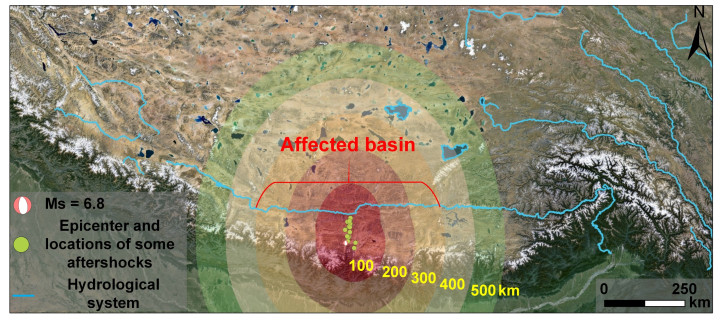
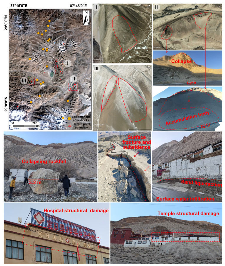
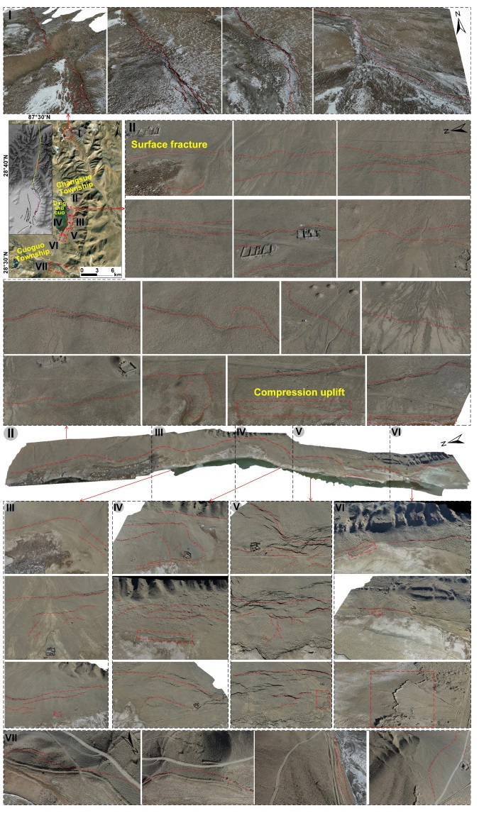
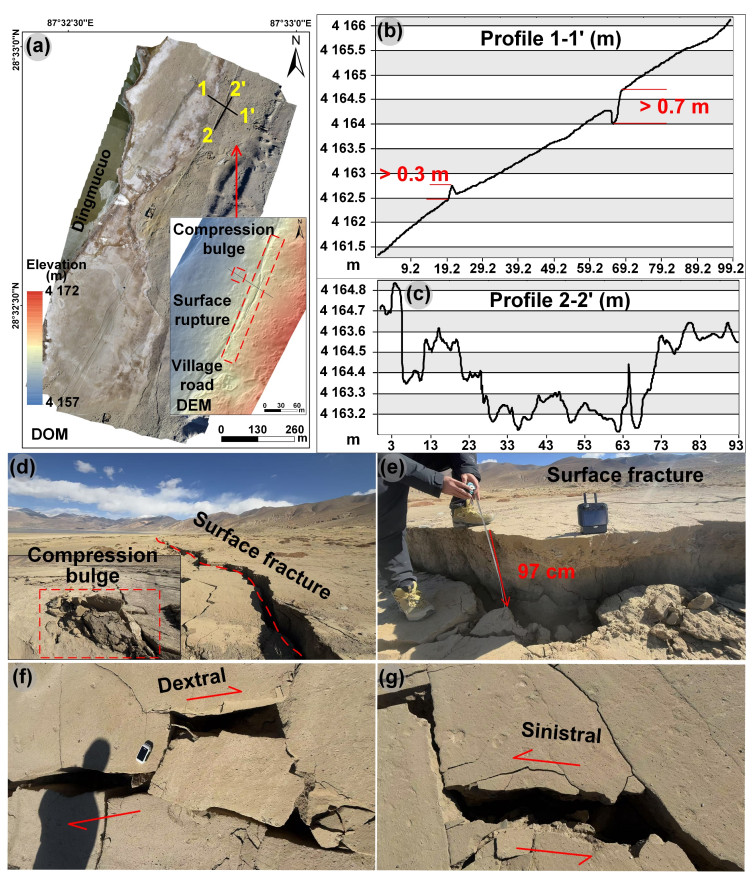
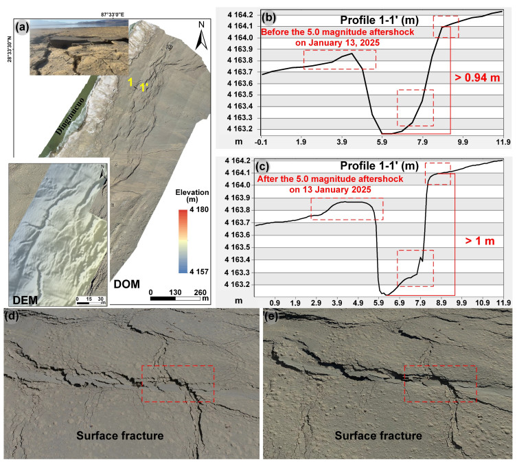
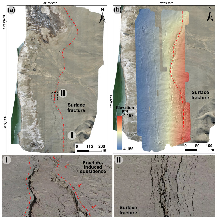
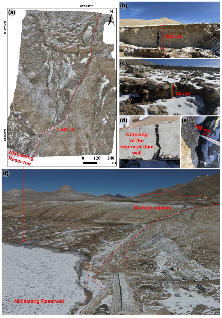
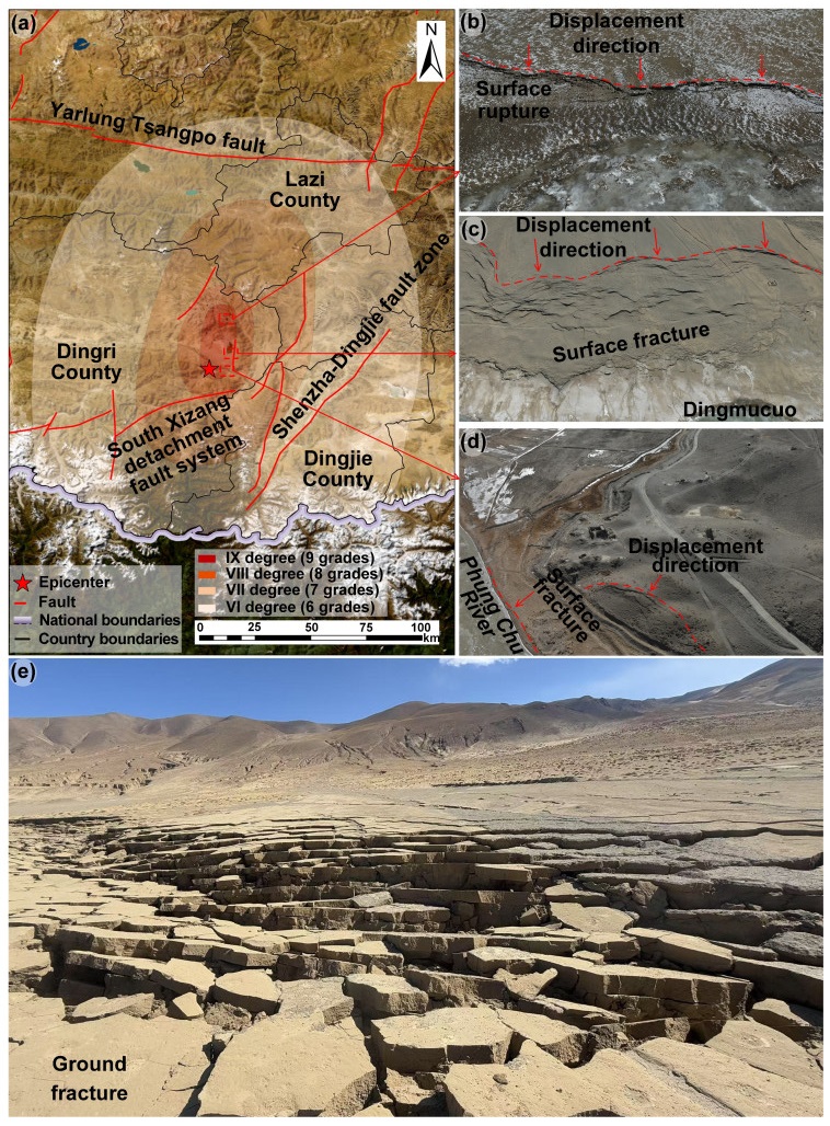
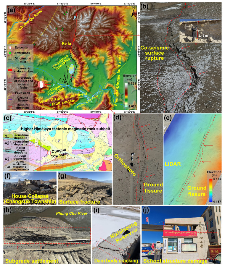
On January 7, 2025, an

| Bai, Y., Zhang, S. J., Dong, Y. G., et al., 2012. Gravity Field Characteristics and Fault Structures in the Dingri-Muztagh Peak Area, Qinghai-Tibet Plateau. Geological Review, 58(2): 237–249. https://doi.org/10.16509/j.georeview.2012.02.016 (in Chinese with English Abstract) |
| Chen, G. H., Li, Z. W., Xu, X. W., et al., 2022. Co-Seismic Surface Deformation and Late Quaternary Accumulated Displacement along the Seismogenic Fault of the 2021 Madoi M7.4 Earthquake and Their Implications for Regional Tectonics. Chinese Journal of Geophysics, 65(8): 2984–3005. https://doi.org/10.6038/cjg2022P0873 (in Chinese with English Abstract) |
| Chen, W. K., Wang, D., Zhang, C., et al., 2022. Estimating Seismic Intensity Maps of the 2021 Mw 7.3 Madoi, Qinghai and Mw 6.1 Yangbi, Yunnan, China Earthquakes. Journal of Earth Science, 33(4): 839–846. https://doi.org/10.1007/s12583-021-1586-9 |
| Chen, Z. Y., 2017. Mechanisms and Seismic Damage Control of Underground Large-Space Structures in Deep Soft Soil. Tongji University, Shanghai. March 20 (in Chinese) |
| Costantini, M., 1998. A Novel Phase Unwrapping Method Based on Network Programming. IEEE Transactions on Geoscience and Remote Sensing, 36(3): 813–821. https://doi.org/10.1109/36.673674 |
| Deng, Q. D., Cheng, S. P., Ma, J., et al., 2014. Characteristics of Seismic Activity and Current Seismic Trends in the Qinghai-Tibet Plateau. Chinese Journal of Geophysics, 57(7): 2025–2042 (in Chinese with English Abstract) |
| Dou, J., Xiang, Z. L., Xu, Q., et al., 2023. Application and Development Trend of Machine Learning in Landslide Intelligent Disaster Prevention and Mitigation. Earth Science, 48(5): 1657–1674 (in Chinese with English Abstract) |
| Dou, J., Yunus, A. P., Merghadi, A., et al., 2020. Different Sampling Strategies for Predicting Landslide Susceptibilities are Deemed Less Consequential with Deep Learning. Science of the Total Environment, 720: 137320. https://doi.org/10.1016/j.scitotenv.2020.137320 |
| Duman, T. Y., Emre, Ö., 2013. The East Anatolian Fault: Geometry, Segmentation and Jog Characteristics. Geological Society, London, Special Publications, 372(1): 495–529. https://doi.org/10.1144/sp372.14 |
| Guo, Y. L., Li, H. F., Liang, P., et al., 2024. Preliminary Report of Coseismic Surface Rupture (Part) of Türkiye's Mw7.8 Earthquake by Remote Sensing Interpretation. Earthquake Research Advances, 4(1): 100219. https://doi.org/10.1016/j.eqrea.2023.100219 |
| Ha, G. H., Liu, J. R., Ren, Z. K., et al., 2022. The Interpretation of Seismogenic Fault of the Maduo Mw 7.3 Earthquake, Qinghai Based on Remote Sensing Images—A Branch of the East Kunlun Fault System. Journal of Earth Science, 33(4): 857–868. https://doi.org/10.1007/s12583-021-1556-2 |
| Huang, T., Wu, Z. H., Han, S., et al., 2024. Active Fault Characteristics and Potential Seismic Risk Assessment in Shigatse, Tibet. Progress in Earthquake Science, 54(10): 696–711. https://doi.org/10.19987/j.dzkxjz.2024-003 (in Chinese with English Abstract) |
|
Institute of Geology, China Earthquake Administration, 2025. Preliminary Analysis of Crustal Deformation and Fault Models of the 2025 Ms 6.8 Dingri Earthquake in Tibet. [2025-1-9]. |
| Jara-Muñoz, J., Melnick, D., Li, S., et al., 2022. The Cryptic Seismic Potential of the Pichilemu Blind Fault in Chile Revealed by Off-Fault Geomorphology. Nature Communications, 13: 3371. https://doi.org/10.1038/s41467-022-30754-1 |
| Kang, D. J., Chen, W. K., Zhao, H. Q., et al., 2023. Rapid Assessment of the September 5, 2022 Ms 6.8 Luding Earthquake in Sichuan, China. Earthquake Research Advances, 3(2): 100214. https://doi.org/10.1016/j.eqrea.2023.100214 |
| Krüger, F., Ohrnberger, M., 2005. Tracking the Rupture of the Mw = 9.3 Sumatra Earthquake over 1150 km at Teleseismic Distance. Nature, 435: 937–939. https://doi.org/10.1038/nature03696 |
| Kusky, T., Bozkurt, E., Meng, J. N., et al., 2023. Twin Earthquakes Devastate Türkiye and Syria: First Report from the Epicenter: A Deadly Dance of the Plates: Arabia Takes a Step to the North, and Anatolia Jumps to the West. Journal of Earth Science, 34(2): 291–296. https://doi.org/10.1007/s12583-023-1317-5 |
| Li, Y. H., Cui, D. X., Hao, M., 2015. GPS-Constrained Inversion of Slip Rate on Major Active Faults in the Northeastern Margin of Tibet Plateau. Earth Science, 40(10): 1767–1780 (in Chinese with English Abstract) |
| Li, Y. S., Li, W. L., Xu, Q., et al., 2025. InSAR Coseismic Deformation Detection and Fault Slip Distribution Inversion of the Dingri Earthquake with Ms 6.8 in Tibet on January 7, 2025. Journal of Chengdu University of Technology (Science & Technology Edition). Online first. 1–13. https://kns.cnki.net/kcms/detail/51.1634.N.20250117.1150.002.html (in Chinese with English Abstract) |
| Liu, J., Chen, T., Zhang, P. Z., et al., 2013. Illuminating the Active Haiyuan Fault, China by Airborne Light Detection and Ranging. Chinese Science Bulletin, 58(1): 41–45 (in Chinese with English Abstract) |
| Lu, H. Y., Li, W. L., Xu, Q., et al., 2019. Early Detection of Landslides in the Upstream and Downstream Areas of the Baige Landslide, the Jinsha River Based on Optical Remote Sensing and InSAR Technologies. Geomatics and Information Science of Wuhan University, 44(9): 1342–1354 (in Chinese with English Abstract) |
| Lu, M. Y., Zhao, X. X., Wang, J. P., et al., 2024. Discussion and Analysis of Seismic Disaster Characteristics of the 6.2 Jishishan Earthquake in Gansu. Progress in Earthquake Science. Online first (in Chinese with English Abstract) |
| Mao, Z. J., Yu, H. Y., Liang, W., et al., 2024. Identification and Feature Analysis of Regional Loess Landslides Based on UAV Tilt Photogrammetry 3D Modeling. Geology in China, 51(2): 561–576 (in Chinese with English Abstract) |
| Mei, J. T., Wan, Y. G., 2024. Estimation of Coseismic Rupture Distribution of Twin Earthquakes in Türkiye Based on Priori Constraints and InSAR Data. Earth Science, 49(8): 2961–2978(in Chinese with English Abstract) |
| Meng, J., Kusky, T., Mooney, W. D., et al., 2024. Surface Deformations of the 6 February 2023 Earthquake Sequence, Eastern Türkiye. Science, 383(6680): 298–305. https://doi.org/10.1126/science.adj3770 |
| Nsangou Ngapna, M., Owona, S., Mvondo Owono, F., et al., 2018. Tectonics, Lithology and Climate Controls of Morphometric Parameters of the Edea-Eseka Region (SW Cameroon, Central Africa): Implications on Equatorial Rivers and Landforms. Journal of African Earth Sciences, 138: 219–232. https://doi.org/10.1016/j.jafrearsci.2017.11.008 |
| Pan, Z. Y., He, J. K., Shao, Z. G., 2020. Spatial Variation in the Present-Day Stress Field and Tectonic Regime of Northeast Tibet from Moment Tensor Solutions of Local Earthquake Data. Geophysical Journal International, 221(1): 478–491. https://doi.org/10.1093/gji/ggaa013 |
| Peng, L., Xu, S. N., Mei, J. J., et al., 2017. Recognition of Earthquake-Induced Landslides Using High-Resolution Remote Sensing Imagery. Journal of Remote Sensing, 21(4): 21–30 (in Chinese with English Abstract) |
| Sarma, J. N., Sharma, S., 2018. Neotectonic Activity of the Bomdila Fault in Northeastern India from Geomorphological Evidences Using Remote Sensing and GIS. Journal of Earth System Science, 127(8): 113. https://doi.org/10.1007/s12040-018-1008-2 |
| Wan, Y. G., Shen, Z. K., Bürgmann, R., et al., 2017. Fault Geometry and Slip Distribution of the 2008 Mw 7.9 Wenchuan, China Earthquake, Inferred from GPS and InSAR Measurements. Geophysical Journal International, 208(2): 748–766. https://doi.org/10.1093/gji/ggw421 |
| Wang, F. C., 2023. Factors and Prediction Models of Seismic Ground Motion Topographic Effects: [Dissertation]. Institute of Engineering Mechanics, China Earthquake Administration, Beijing (in Chinese with English Abstract) |
| Wang, S. H., Ai, M., Wu, C. Y., et al., 2018. Application of High-Resolution Satellite Imagery-Derived DEM in Quantitative Research of Active Tectonics: A Case Study of the Southern Margin Fault of the Kumishi Basin. Seismology and Geology, 40(5): 999–1017(in Chinese with English Abstract) |
| Wang, Y. P., Shen, J., Song, Y. J., et al., 2017. Interpretation of Fault Characteristics in Funiu Mountains, Western Henan Based on ASTER GDEM. China Earthquake Engineering Journal, 39(4): 767–773. https://doi.org/10.3969/j.issn.1000-0844.2017.04.0767 (in Chinese with English Abstract) |
| Wang, Y., Zhang, B., Hou, J. J., et al., 2014. Structure and Tectonic Geomorphology of the Qujiang Fault at the Intersection of the Ailao Shan-Red River Fault and the Xianshuihe-Xiaojiang Fault System, China. Tectonophysics, 634: 156–170. https://doi.org/10.1016/j.tecto.2014.07.031 |
| Wu, Z. H., Long, C. X., Fan, T. Y., et al., 2015. Arc-Twisting Tectonic Systems and Their Dynamic Characteristics in the Southeastern Qinghai-Tibet Plateau. Geological Bulletin of China, 34(1): 1–31(in Chinese with English Abstract) |
| Xing, K., Li, H., Zhang L. L., et al., 2025. Analysis of Surface Rupture and Seismic Damage Characteristics of the January 7, 2025, Dingri Ms6.8 Earthquake in Xizang. Safety and Environmental Engineering, Online First. https://doi.org/10.13578/j.cnki.issn.1671-1556.20250133. |
| Xu, Q., 2020. Insights and Thoughts on the Early Identification of Geological Disaster Hazards. Journal of Wuhan University (Information Science Edition), 45(11): 1651–1659 (in Chinese with English Abstract) |
| Xu, Q., Dong, X. J., Li, W. L., et al., 2019. Early Identification and Monitoring and Warning of Major Geological Disaster Hazards Based on Air-Space-Ground Integrated Systems. Journal of Wuhan University (Information Science Edition), 44(7): 957–966 (in Chinese with English Abstract) |
| Yang, Y. C., Dou, J., Merghadi, A., et al., 2024. Advanced Prediction of Landslide Deformation through Temporal Fusion Transformer and Multivariate Time-Series Clustering of InSAR: Insights from the Badui Region, Eastern Tibet. IEEE Transactions on Geoscience and Remote Sensing, 62: 4514219. https://doi.org/10.1109/TGRS.2024.3504241 |
| You, Z. C., Bi, H. Y., Zheng, W. J., et al., 2023. Fine Characteristic Study of Earthquake Rupture Zone Based on High-Resolution Remote Sensing Imagery: A Case Study of the Litang Fault. Seismology and Geology, 45(5): 1057–1073. https://doi.org/10.3969/j.issn.0253-4967.2023.05.002 (in Chinese with English Abstract) |
| Yu, J. C., Li, S. W., Yuan, D. Y., et al., 2025. Late Quaternary Tectonic Deformation and Earthquake Mechanism of Xinminbao Fault Revealed by UAV Photogrammetry. Earth Science. Online first. 1–16 (in Chinese with English Abstract) |
| Zhang, C. L., Li, Z. H., Zhang, S. C., et al., 2022. Comprehensive Remote Sensing Interpretation of the 2022 Mw6.7 Menyuan, Qinghai Earthquake Surface Rupture Zone. Journal of Wuhan University (Information Science Edition), 47(8): 1257–1270 (in Chinese with English Abstract) |
| Zhang, J. J., Guo, L., Ding, L., et al., 2002. Structural Characteristics of the Middle and Southern Segments of the Shenzha-Dingjie Normal Fault System and Their Relationship with the South Tibetan Detachment System. Chinese Science Bulletin, 47(10): 738–743 (in Chinese with English Abstract) |
| Zhang, J. L., Gong, Q. Z., 2024. Analysis of Seismic Tectonic Features in Tibet Autonomous Region. Tibet Science and Technology, 46(12): 13–18+40 (in Chinese with English Abstract) |
| Zhang, L. L., Zhang, R. Q., Dou, J., et al., 2025. Advancing Reservoir Landslide Stability Assessment via TS-InSAR and Airborne LiDAR Observations in the Daping Landslide Group, Three Gorges Reservoir Area, China. Landslides, 22(1): 169–188. https://doi.org/10.1007/s10346-024-02337-2 |
| Zhou, Y., Parsons, B., Elliott, J. R., et al., 2015. Assessing the Ability of Pleiades Stereo Imagery to Determine Height Changes in Earthquakes: A Case Study for the El Mayor-Cucapah Epicentral Area. Journal of Geophysical Research: Solid Earth, 120(12): 8793–8808. https://doi.org/10.1002/2015jb012358 |
| Zhu, J. J., Li, Z. W., Hu, J., 2017. Research Progress and Methods of InSAR for Deformation Monitoring. Acta Geodaetica et Cartographica Sinica, 46(10): 1717–1733. https://doi.org/10.11947/j.AGCS.2017.20170350 (in Chinese with English Abstract) |
Figures(12)
Copyright © 2013-2020 Journal of Earth Science 鄂ICP备15021562号-2
Tel: +86-27-67885075 Fax: +86-27-67885075 E-mail: xbb@cug.edu.cn
Address: Editorial Office of Journal, China University of Geosciences, Yujiashan, Wuhan, Hubei 430074, P. R. China
Supported by:
Beijing Renhe Information Technology Co. Ltd
E-mail:
info@rhhz.net


 DownLoad: