| Citation: | Yanwen Chen, Daoyang Yuan, Hao Sun, Yan Zhan, Hongqiang Li, Yameng Wen, Ruihuan Su, Jinchao Yu. Characteristics of the Recently Identified Seismic Surface Rupture Zone along the Eastern Segment of the Kunzhong Fault and Its Seismogeological Significance, Northern Tibetan Plateau. Journal of Earth Science, 2026, 37(2): 427-442. doi: 10.1007/s12583-025-0232-3

|
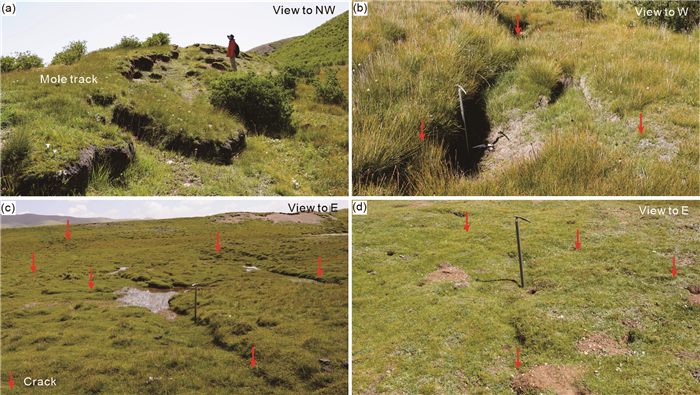
The Tibetan Plateau is one of the regions with the most active neotectonic movement and frequent seismic activity in the world. The Bayan Har Block, located in the Northern Tibetan Plateau, has been the main area for clusters of major earthquakes with

| Bao, G. D., Ren, Z. K., Ha, G. H., et al., 2024. New Evidence of Late Quaternary Tectonic Activity along the Eastern Margin of the Qaidam Basin. Tectonics, 43(1): e2023TC007906. https://doi.org/10.1029/2023tc007906 |
| Bemis, S. P., Micklethwaite, S., Turner, D., et al., 2014. Ground-Based and UAV-Based Photogrammetry: A Multi-Scale, High-Resolution Mapping Tool for Structural Geology and Paleoseismology. Journal of Structural Geology, 69: 163–178. https://doi.org/10.1016/j.jsg.2014.10.007 |
| Bi, H. Y., Zheng, W. J., Ren, Z. K., et al., 2017. Using an Unmanned Aerial Vehicle for Topography Mapping of the Fault Zone Based on Structure from Motion Photogrammetry. International Journal of Remote Sensing, 38(8/9/10): 2495–2510. https://doi.org/10.1 080/01431161.2016.1249308 doi: 10.1080/01431161.2016.1249308 |
| Blaser, L., Kruger, F., Ohrnberger, M., et al., 2010. Scaling Relations of Earthquake Source Parameter Estimates with Special Focus on Subduction Environment. Bulletin of the Seismological Society of America, 100(6): 2914–2926. https://doi.org/10.1785/0120100111 |
| Chen, W. B., Xu, X. W., Liu, B. C., 2000. Earthquake Clustering and Fault Interactions: A Discussion on the Seismic Hazard in the East Qilian Mountains, China. Northwestern Seismological Journal, 2: 23–30 (in Chinese with English Abstract) |
| Chen, Y. H., Zhang, T. J., Sun, H. B., 2001. Macroscopic Seismic Survey and Structure of Xinghai Earthquake with MS6.6 on Sept. 12, 2000. Earthquake Research in Plateau, 1: 54–59 (in Chinese with English Abstract) |
| Deng, Q. D., Yu, G. H., Ye, W. H., 1992. Study on the Relations Between Parameters of Surface Rupture and Magnitude. Seismological Press, Beijing (in Chinese) |
| Deng, Q. D., Gao, X., Chen, G. H., et al., 2010. Recent Tectonic Activity of Bayankala Fault-Block and the Kunlun-Wenchuan Earthquake Series of the Tibetan Plateau. Earth Science Frontiers, 17(5): 163–178 (in Chinese with English Abstract) |
| Eberhart-Phillips, D., Haeussler, P. J., Freymueller, J. T., et al., 2003. The 2002 Denali Fault Earthquake, Alaska: A Large Magnitude, Slip-Partitioned Event. Science, 300(5622): 1113–1118. https://doi.org/10.1126/science.1082703 |
| Fu, Z. X., Liu, G. P., Chen, Q. F., 2001. Dynamic Analysis on Interaction between the Haiyuan-Gulang-Changma Great Earthquake in the North Boundary of the Tibetan Plateau. Seismology and Geology, 23(1): 35–42 (in Chinese with English Abstract) |
| Gu, G. X., 1983. The Catalogue of Earthquakes in China (1831 B. C.-1969 A. D.). Science Press, Beijing (in Chinese) |
|
Guo, J., Lin, A., Sun, G., et al., 2007. Surface Ruptures Associated with the 1937 M 7.5 Tuosuo Lake and the 1963 M 7.0 Alake Lake Earthquakes and the Paleoseismicity along the Tuosuo Lake Segment of the Kunlun Fault, Northern Tibet. Bulletin of the Seismological Society of America, 97(2): 474–496. |
| Ha, G. H., Ren, Z. K., Liu, J. R., et al., 2021. New Discovery of Xiariha Fault Zone around Dulan Area, Qinghai Province and Its Tectonic Implications. Seismology and Geology, 43 (3): 614–629 (in Chinese with English Abstract) |
| Hamling, I. J., Hreinsdóttir, S., Clark, K., et al., 2017. Complex Multifault Rupture during the 2016 Mw 7.8 Kaikōura Earthquake, New Zealand. Science, 356(6334): eaam7194. https://doi.org/10.1126/science.aam7194 |
| Harris, R. A., 1998. Introduction to Special Section: Stress Triggers, Stress Shadows, and Implications for Seismic Hazard. Journal of Geophysical Research, 103(10): 24347–24358. https://doi.org/10.1029/98jb01576 |
| Harwin, S., Lucieer, A., 2012. Assessing the Accuracy of Georeferenced Point Clouds Produced via Multi-View Stereopsis from Unmanned Aerial Vehicle (UAV) Imagery. Remote Sensing, 4(6): 1573–1599. https://doi.org/10.3390/rs40 61573 doi: 10.3390/rs4061573 |
| Huang, X. N., Yang, X. P., Hu, Z. K., et al., 2023. Characteristics of the Late-Quaternary Activity of the Western Segment of Bailongjiang Fault. Technology for Earthquake Disaster Prevention, 18 (4): 701–717 (in Chinese with English Abstract) |
| Jagla, E. A., Kolton, A. B., 2010. A Mechanism for Spatial and Temporal Earthquake Clustering. Journal of Geophysical Research: Solid Earth, 115(B5): B05312. https://doi.org/10.1029/2009jb006974 |
| King, G., Stein, R., Lin, J., 1994. Static Stress Changes and the Triggering of Earthquakes. Bulletin of the Seismological Society of America, 84(3): 935–953 |
| Lee, J., Tsai, V. C., Hirth, G., et al., 2024. Fault-Network Geometry Influences Earthquake Frictional Behaviour. Nature, 631(8019): 106–110. https://doi.org/10.1038/s41586-024-07518-6 |
| Li, C. X., Dai, H. G., Chen, Y. M., et al., 2006. The Discussion on Some Problems of the MS7.5 Tuosuohu Lake Earthquake in 1937. Seismology and Geology, 28(1): 12–21 (in Chinese with English Abstract) |
| Li, C. X., Xu, X. W., Wen, X. Z., et al., 2011. Rupture Segmentation and Slip Partitioning of the Mid-Eastern Part of the Kunlun Fault, North Tibetan Plateau. Science China Earth Sciences, 54(11): 1730–1745. https://doi.org/10.1007/s11430-011-4239-5 |
| Li, C. X., Yuan, D. Y., Yang, H., et al., 2016. The Tectonic Activity Characteristic of Awancang Fault in the Late Quaternary, the Sub-Strand of the East Kunlun Fault. Seismology and Geology, 38(1): 44–64 (in Chinese with English Abstract) |
| Li, H. B., Pan, J. W., Sun, Z. M., et al., 2021. Continental Tectonic Deformation and Seismic Activity: A Case Study from the Tibetan Plateau. Acta Geologica Sinica, 95 (1): 194–213 (in Chinese with English Abstract) |
| Li, Z. M., Ren, Z. K., Liu, J. R., et al., 2020. New Discovery of Reshui-Taostuo River Fault in Dulan, Qinghai Province and Its Implications. Seismology and Geology, 42 (1): 18–32 (in Chinese with English Abstract) |
| Meng, J. N., Kusky, T., Mooney, W. D., et al., 2024. Surface Deformations of the 6 February 2023 Earthquake Sequence, Eastern Türkiye. Science, 383(6680): 298–305. https://doi.org/10.1126/science.adj3770 |
| Pan, J. W., Li, H. B., Chevalier, M. L., et al., 2022. Co-Seismic Rupture of the 2021, Mw 7.4 Maduo Earthquake (Northern Tibet): Short-Cutting of the Kunlun Fault Big Bend. Earth and Planetary Science Letters, 594: 117703. https://doi.org/10.1016/j.epsl.2022.117703 |
| Ran, H. L., 2011. Empirical Relations between Earthquake Magnitude and Parameters of Strike-Slip Seismogenic Active Faults Associated with Historical Earthquakes in Western China. Seismology and Geology, 33(3): 577–585 (in Chinese with English Abstract) |
| Ran, Y. K., Xu, X. W., Wang, H., et al., 2019. Evidence of Characteristic Earthquakes on Thrust Faults from Paleo-Rupture Behavior along the Longmenshan Fault System. Tectonics, 38(7): 2401–2410. https://doi.org/10.1029/2019tc00 5495 doi: 10.1029/2019tc005495 |
| Ren, J. J., Xu, X. W., Zhang, S. M., et al., 2017. Tectonic Transformation at the Eastern Termination of the Eastern Kunlun Fault Zone and Seismogenic Mechanism of the 8 August 2017 Jiuzhaigou MS7.0 Earthquake. Chinese Journal of Geophysics, 60(10): 4027–4045 (in Chinese with English Abstract) |
| Sieh, K., Jones, L., Hauksson, E., et al., 1993. Near-Field Investigations of the Landers Earthquake Sequence, April to July 1992. Science, 260(5105): 171–176. https://doi.org/10.1126/science.260.5105.171 |
| Stein, R. S., 1999. The Role of Stress Transfer in Earthquake Occurrence. Nature, 402(6762): 605–609. https://doi.org/10.10 38/45144 doi: 10.1038/45144 |
| Sun, X. Y., Zhan, Y., Zhao, L. Q., et al., 2019. Electrical Structure of the Kunlun-Qinling Fault System, Northeastern Tibetan Plateau, Inferred from 3-D Inversion of Magnetotelluric Data. Journal of Asian Earth Sciences, 181: 103910. https://doi.org/10.1016/j.jse aes.2019.103910 doi: 10.1016/j.jseaes.2019.103910 |
| Sun, X. Y., Zhan, Y., Unsworth, M., et al., 2020.3-D Magnetotelluric Imaging of the Easternmost Kunlun Fault: Insights into Strain Partitioning and the Seismotectonics of the Jiuzhaigou MS7.0 Earthquake. Journal of Geophysical Research: Solid Earth, 125(5): e2020JB019731. https://doi.org/10.1029/2020jb019731 |
| Van Der Woerd, J., Tapponnier, P., Ryerson, F. J., et al., 2002. Uniform Postglacial Slip-Rate along the Central 600 km of the Kunlun Fault (Tibet), from 26Al, 10Be, and 14C Dating of Riser Offsets, and Climatic Origin of the Regional Morphology. Geophysical Journal International, 148(3): 356–388. https://doi.org/10.1046/j.1365-246x.2002.01556.x |
| Wang, E., Burchfiel, B. C., 2004. Late Cenozoic Right-Lateral Movement along the Wenquan Fault and Associated Deformation: Implications for the Kinematic History of the Qaidam Basin, Northeastern Tibetan Plateau. International Geology Review, 46(10): 861–879. https://doi.org/10.2747/0020-6814.46.10.861 |
| Wang, L., Liu, A. W., Li, X. X., et al., 2022. Estimation of Average Displacement of Fault Surface Co-Seismic Dislocations. Acta Seismologica Sinica, 44(5): 845–852 (in Chinese with English Abstract) |
| Wen, X. Z., Yi, G. X., Xu, X. W., 2007. Background and Precursory Seismicities along and Surrounding the Kunlun Fault before the MS8.1, 2001, Kokoxili Earthquake, China. Journal of Asian Earth Sciences, 30(1): 63–72. https://doi.org/10.1016/j.jseaes.2006.0 7.008 |
| Wen, Y. M., Fang, Z. B., He, K. F., et al., 2023a. Present-Day Crustal Deformation of the Maqên-Maqu Segment in the East Kunlun Fault Zone Revealed by Sentinel-1 Images. Chinese Journal of Geophysics, 66(11): 4517–4532 (in Chinese with English Abstract) |
| Wen, Y. M., Yuan, D. Y., Xie, H., et al., 2023b. Typical Fine Structure and Seismogenic Mechanism Analysis of the Surface Rupture of the 2022 Menyuan Mw6.7 Earthquake. Remote Sensing, 15(18): 4375. https://doi.org/10.3390/rs15184375 |
| Wells, D. L., Coppersmith, K. J., 1994. New Empirical Relationships among Magnitude, Rupture Length, Rupture Width, Rupture Area, and Surface Displacement. Bulletin of the Seismological Society of America, 84(4): 974–1002. https://doi.org/10.1785/bssa0840040974 |
| Westoby, M. J., Brasington, J., Glasser, N. F., et al., 2012. 'Structure-from-Motion' Photogrammetry: A Low-Cost, Effective Tool for Geoscience Applications. Geomorphology, 179: 300–314. https://doi.org/10.1016/j.geomorph.2012.08.021 |
| Xiao, Z. M., Liu, G. X., Wang, H. Z., et al., 1988. A Preliminary Study on the Seismic Deformation Zone at Huashixia in Qinghai Province. Earthquake Research in China, 4(1): 70–77 (in Chinese with English Abstract) |
| Xu, D. Y., Xiao, J., He, J. K., et al., 2020. Strong Earthquake Clustering around the Eastern Tibetan Plateau after the 2008 Mw 7.9 Wenchuan Earthquake. Science China Earth Sciences, 50(6): 851–864 (in Chinese with English Abstract) |
| Xu, D. Y., Li, Z. B., Zhang, Z. G., et al., 2024. The 2022 Mw6.6 Menyuan Earthquake: An Early-Terminated Runaway Rupture by the Complex Fault Geometry. Earth and Planetary Science Letters, 638: 118746. https://doi.org/10.1016/j.epsl.2024.118746 |
|
Xu, X. W., Yu, G. H., Klinger, Y., et al., 2006. Reevaluation of Surface Rupture Parameters and Faulting Segmentation of the 2001 Kunlunshan Earthquake (Mw7.8), Northern Tibetan Plateau, China. Journal of Geophysical Research: Solid Earth, 111(B5): B05316. |
| Yin, X., Liu, W., Yao, S. H., et al., 2022. Micro Landform Extraction Based on UAV Photography Technology-Taking Kunzhong Fault(Balong Wenquan Section) as an Example. Technology for Earthquake Disaster Prevention, 17(4): 701–709 (in Chinese with English Abstract) |
| Yuan, D. Y., Champagnac, J. D., Ge, W. P., et al., 2011. Late Quaternary Right-Lateral Slip Rates of Faults Adjacent to the Lake Qinghai, Northeastern Margin of the Tibetan Plateau. Geological Society of America Bulletin, 123(9/10): 2016–2030. https://doi.org/10.1130/b30315.1 |
| Yuan, D. Y., Wang, Y. L., Li, S. W., et al., 2023a. Critical Links and Development Trends of Research on Active Tectonics. Coal Geology & Exploration, 51(12): 17–28 (in Chinese with English Abstract) |
| Yuan, D. Y., Xie, H., Su, R. H., et al., 2023b. Characteristics of Co-Seismic Surface Rupture Zone of Menyuan MS6.9 Earthquake in Qinghai Province on January 8, 2022 and Seismogenic Mechanism. Chinese Journal of Geophysics, 66(1): 229–244 (in Chinese with English Abstract) |
| Yuan, Z. D., Li, J. L. X., Xu, J., et al., 2021. Detailed Mapping of the Surface Rupture of the 12 February 2014 Yutian MS7.3 Earthquake, Altyn Tagh Fault, Xinjiang, China. Science China Earth Sciences, 64(1): 127–147 (in Chinese with English Abstract) |
| Zhan, Y., Liang, M. J., Sun, X. Y., et al., 2021. Deep Structure and Seismogenic Pattern of the 2021.5. 22 Madoi (Qinghai) MS7.4 Earthquake. Chinese Journal of Geophysics, 64(7): 2232–2252 (in Chinese with English Abstract) |
| Zhang, P. Z., Deng, Q. D., Zhang, G. M., et al., 2003. Active Tectonic Blocks and Strong Earthquakes in the Continent of China. Science in China Series D: Earth Sciences, 46: 13–24. https://doi.org/10.1360/03dz0002 |
| Zhao, D. Z., Qu, C. Y., Bürgmann, R., et al., 2022. Large-Scale Crustal Deformation, Slip-Rate Variation, and Strain Distribution along the Kunlun Fault (Tibet) from Sentinel-1 InSAR Observations (2015–2020). Journal of Geophysical Research: Solid Earth, 127(1): e2021JB022892. https://doi.org/10.1029/20 21jb022892 doi: 10.1029/2021jb022892 |
Figures(11)
Copyright © 2013-2020 Journal of Earth Science 鄂ICP备15021562号-2
Tel: +86-27-67885075 Fax: +86-27-67885075 E-mail: xbb@cug.edu.cn
Address: Editorial Office of Journal, China University of Geosciences, Yujiashan, Wuhan, Hubei 430074, P. R. China
Supported by:
Beijing Renhe Information Technology Co. Ltd
E-mail:
info@rhhz.net


 DownLoad: