| Citation: | Ran Lu, Hua Chen, Zhao Li, Mingyuan Zhang, Yanming Feng, Weiping Jiang. Detection of Storm Surge-Induced Non-Tidal Ocean Loading Deformation in Hong Kong Using Sub-Daily GNSS Observations. Journal of Earth Science, 2026, 37(5): 2415-2431. doi: 10.1007/s12583-025-0370-7

|
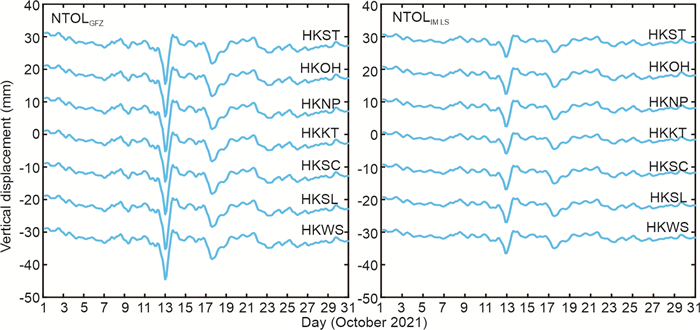
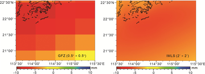
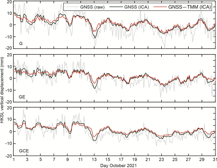
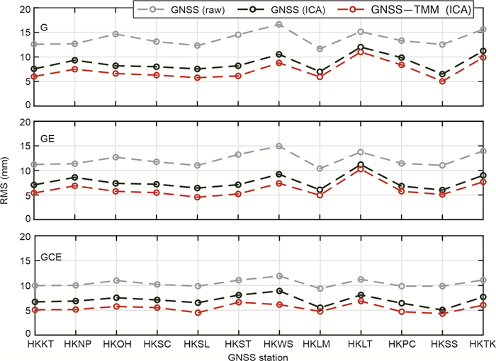
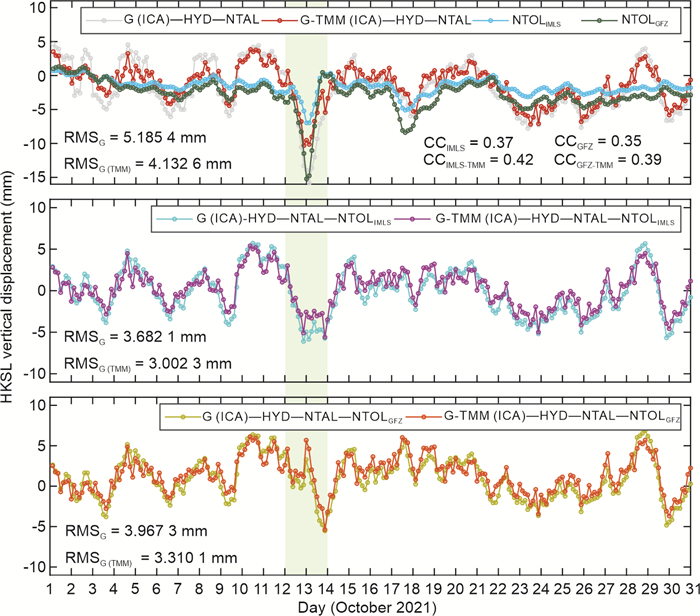
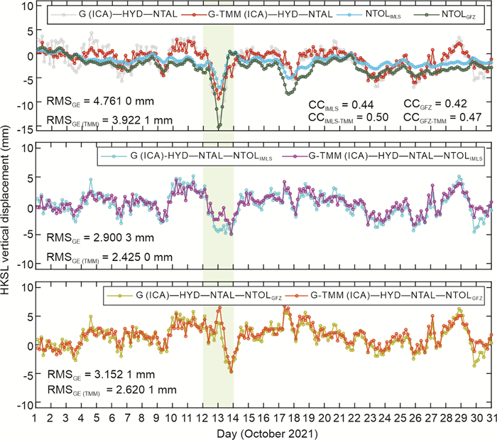
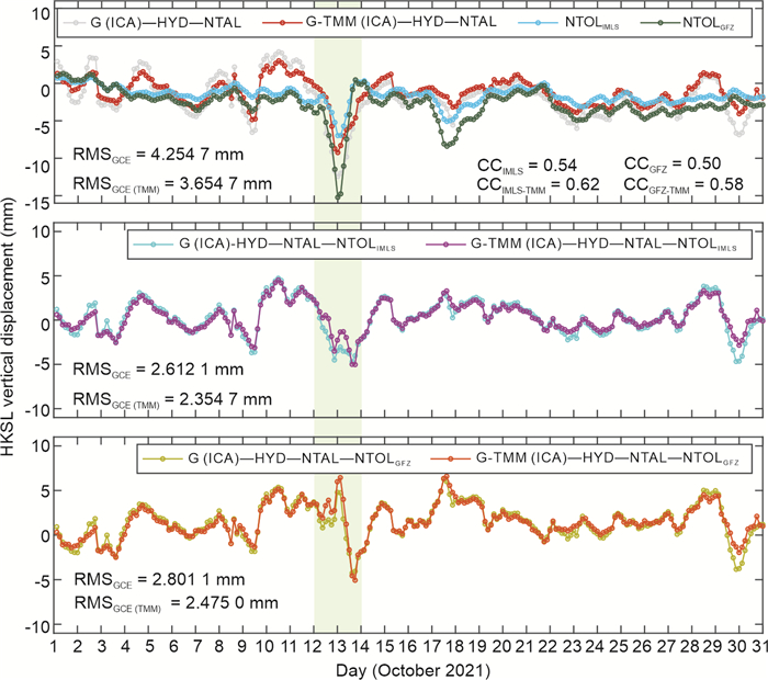
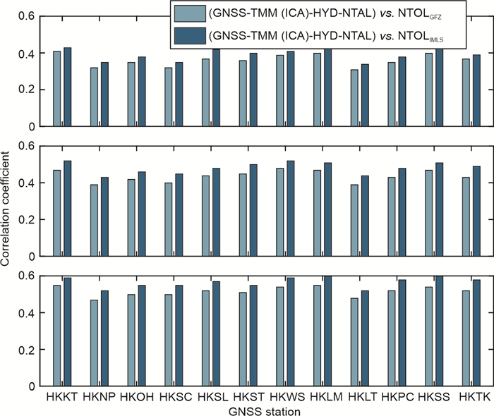
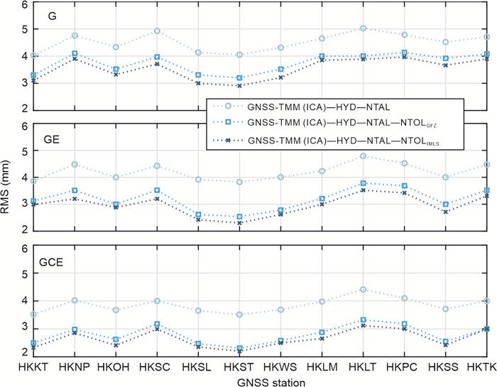
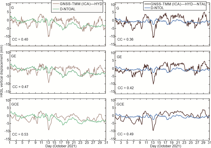
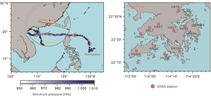
Storm surges occurring over short periods can cause abrupt changes in ocean mass near the coast, leading to transient crustal subsidence known as Non-Tidal Ocean Loading (NTOL). Existing NTOL products provided by various institutions are typically derived from oceanic gravity or fluid dynamic models combined with Earth's elastic response theory. However, these model-based products lack validation against in-situ observations, raising concerns about their reliability under extreme conditions. In contrast, geodetic Global Navigation Satellite Systems (GNSS) observations offer high accuracy, high spatiotemporal resolution, and near real-time availability. In this study, we analyze sub-daily GNSS vertical displacements from 12 stations in Hong Kong during a storm surge in October 2021 and compare them with NTOL predictions from three global models (GFZ, IMLS, and GGFC) to assess their consistency in a complex coastal environment. Results show that the IMLS and GGFC NTOL products are more reliable than the GFZ product for detecting sub-daily loading deformations in a small region. The GFZ product suffers from spurious NTOL displacement signals (max≈15 mm) during the peak storm surge period. Among the correlation coefficients between 3-h GNSS vertical displacements and the three NTOL products, the IMLS product achieves the highest correlation (max = 0.67), followed by the GGFC product, while the GFZ product exhibits the lowest correlation. Extending the GNSS solution time span (from 3-h to 6-h or 9-h) improves its correlation with NTOL. However, since storm surge effects typically last only tens of minutes to a few hours, a 6-h or 9-h GNSS solution may not capture the full details of the storm surge-induced deformation. Our work demonstrates that sub-daily GNSS observations can detect the transient NTOL-induced subsidence caused by storm surges, thereby validating the accuracy and applicability of these NTOL models and filling the gap left by the lack of observational support in previous model-based studies.

| Boy, J. P., Longuevergne, L., Boudin, F., et al., 2009. Modelling Atmospheric and Induced Non-Tidal Oceanic Loading Contributions to Surface Gravity and Tilt Measurements. Journal of Geodynamics, 48(3/4/5): 182–188. https://doi.org/10.1016/j.jog.2009.09.022 |
| Boy, J. P., Lyard, F., 2008. High-Frequency Non-Tidal Ocean Loading Effects on Surface Gravity Measurements. Geophysical Journal International, 175(1): 35–45. https://doi.org/10.1111/j.13 65-246x.2008.03895.x doi: 10.1111/j.1365-246x.2008.03895.x |
| Dobslaw, H., Bergmann-Wolf, I., Dill, R., et al., 2017. A New High-Resolution Model of Non-Tidal Atmosphere and Ocean Mass Variability for De-Aliasing of Satellite Gravity Observations: AOD1B RL06. Geophysical Journal International, 211(1): 263–269. https://doi.org/10.1093/gji/ggx302 |
| Dong, D., Wang, M., Chen, W., et al., 2016. Mitigation of Multipath Effect in GNSS Short Baseline Positioning by the Multipath Hemispherical Map. Journal of Geodesy, 90(3): 255–262. https://doi.org/10.1007/s00190-015-0870-9 |
| Fenoglio-Marc, L., Scharroo, R., Annunziato, A., et al., 2015. Cyclone Xaver Seen by Geodetic Observations. Geophysical Research Letters, 42(22): 9925–9932. https://doi.org/10.1002/2015gl065989 |
| Flather, R. A., 2000. Existing Operational Oceanography. Coastal Engineering, 41(1/2/3): 13–40. https://doi.org/10.1016/s0378-38 39(00)00025-9 doi: 10.1016/s0378-3839(00)00025-9 |
| Fratepietro, F., Baker, T. F., Williams, S. D. P., et al., 2006. Ocean Loading Deformations Caused by Storm Surges on the Northwest European Shelf. Geophysical Research Letters, 33(6): 2005GL025475. https://doi.org/10.1029/2005gl025475 |
| Geng, J. H., Williams, S. D. P., Teferle, F. N., et al., 2012. Detecting Storm Surge Loading Deformations around the Southern North Sea Using Subdaily GPS: Storm Surge Loading. Geophysical Journal International, 191(2): 569–578. https://doi.org/10.1111/j.1365-246x.2012.05656.x |
| Geng, J. H., Xin, S. M., Williams, S. D. P., et al., 2021. Comparing Non-Tidal Ocean Loading around the Southern North Sea with Subdaily GPS/GLONASS Data. Journal of Geophysical Research: Solid Earth, 126(3): e2020JB020685. https://doi.org/10.1029/2020jb020685 |
| Haigh, I. D., MacPherson, L. R., Mason, M. S., et al., 2014a. Estimating Present Day Extreme Water Level Exceedance Probabilities around the Coastline of Australia: Tropical Cyclone-Induced Storm Surges. Climate Dynamics, 42(1): 139–157. https://doi.org/10.1007/s00382-012-1653-0 |
| Haigh, I. D., Wijeratne, E. M. S., MacPherson, L. R., et al., 2014b. Estimating Present Day Extreme Water Level Exceedance Probabilities around the Coastline of Australia: Tides, Extra-Tropical Storm Surges and Mean Sea Level. Climate Dynamics, 42(1): 121–138. https://doi.org/10.1007/s00382-012-1652-1 |
| Hammond, W. C., Blewitt, G., Kreemer, C., 2016. GPS Imaging of Vertical Land Motion in California and Nevada: Implications for Sierra Nevada Uplift. Journal of Geophysical Research: Solid Earth, 121(10): 7681–7703. https://doi.org/10.1002/2016jb013458 |
| Haritonova, D., 2019. The Impact of the Baltic Sea Non-Tidal Loading on GNSS Station Coordinate Time Series: The Case of Latvia. Baltic Journal of Modern Computing, 7(4): 541–549. https://doi.org/10.22364/bjmc.2019.7.4.07 |
| Heki, K., Jin, S. G., 2023. Geodetic Study on Earth Surface Loading with GNSS and GRACE. Satellite Navigation, 4(1): 24. https://doi.org/10.1186/s43020-023-00113-6 |
| Jin, S. G., Zhang, T. Y., 2016. Terrestrial Water Storage Anomalies Associated with Drought in Southwestern USA from GPS Observations. Surveys in Geophysics, 37(6): 1139–1156. https://doi.org/10.1007/s10712-016-9385-z |
| Johnson, C. W., Fu, Y. N., Bürgmann, R., 2017. Seasonal Water Storage, Stress Modulation, and California Seismicity. Science, 356(6343): 1161–1164. https://doi.org/10.1126/science.aak9547 |
| Jungclaus, J. H., Fischer, N., Haak, H., et al., 2013. Characteristics of the Ocean Simulations in the Max Planck Institute Ocean Model (MPIOM) the Ocean Component of the MPI-Earth System Model. Journal of Advances in Modeling Earth Systems, 5(2): 422–446. https://doi.org/10.1002/jame.20023 |
| Li, Z., Lu, R., Jiang, W. P., et al., 2024. A Refined Full-Spectrum Temperature-Induced Subsurface Thermal Expansion Model and Its Contribution to the Vertical Displacement of Global GNSS Reference Stations. Journal of Geodesy, 98(4): 25. https://doi.org/10.1007/s00190-024-01834-5 |
| Lu, R., Chen, W., Dong, D. N., et al., 2021. Multipath Mitigation in GNSS Precise Point Positioning Based on Trend-Surface Analysis and Multipath Hemispherical Map. GPS Solutions, 25(3): 119. https://doi.org/10.1007/s10291-021-01156-5 |
| Lu, R., Chen, W., Li, Z., et al., 2023. An Improved Joint Modeling Method for Multipath Mitigation of GPS, BDS-3, and Galileo Overlapping Frequency Signals in Typical Environments. Journal of Geodesy, 97(10): 95. https://doi.org/10.1007/s00190-023-01788-0 |
| Lu, R., Chen, W., Zhang, C. L., et al., 2022. Characteristics of the BDS-3 Multipath Effect and Mitigation Methods Using Precise Point Positioning. GPS Solutions, 26(2): 41. https://doi.org/10.10 07/s10291-022-01227-1 doi: 10.1007/s10291-022-01227-1 |
| Lu, R., Li, Z., Chen, Q. S., et al., 2025. On the Contributions of Refined Thermal Expansion Model to Nonlinear Variations in Different GNSS Height Time Series Products. GPS Solutions, 28(2): 80. https://doi.org/10.1007/s10291-024-01625-7 |
| Lu, R., Zhang, M. Y., Yuan, P., et al., 2024. Enhancing Multi-GNSS Positioning Performances in Harsh Environments via a Refined Joint Troposphere-Multipath Hemispherical Map. GPS Solutions, 29(1): 1. https://doi.org/10.1007/s10291-024-01763-y |
| Lyard, F., Lefevre, F., Letellier, T., et al., 2006. Modelling the Global Ocean Tides: Modern Insights from FES2004. Ocean Dynamics, 56(5): 394–415. https://doi.org/10.1007/s10236-006-0086-x |
| Ma, M., Tao, T., Xie, G., et al., 2023. Surface Vertical Deformation in Hong Kong by Combining CORS and Environmental Load Deformation Data. Journal of Geodesy and Geodynamics, 43(3): 246–249 |
| Malys, S., Jensen, P. A., 1990. Geodetic Point Positioning with GPS Carrier Beat Phase Data from the CASA UNO Experiment. Geophysical Research Letters, 17(5): 651–654. https://doi.org/10.1029/gl017i005p00651 |
| Mémin, A., Watson, C., Haigh, I. D., et al., 2014. Non-Linear Motions of Australian Geodetic Stations Induced by Non-Tidal Ocean Loading and the Passage of Tropical Cyclones. Journal of Geodesy, 88(10): 927–940. https://doi.org/10.1007/s00190-014-0734-8 |
| Ming, F., Yang, Y. X., Zeng, A. M., et al., 2017. Spatiotemporal Filtering for Regional GPS Network in China Using Independent Component Analysis. Journal of Geodesy, 91(4): 419–440. https://doi.org/10.1007/s00190-016-0973-y |
| Munekane, H., Matsuzaka, S., 2004. Nontidal Ocean Mass Loading Detected by GPS Observations in the Tropical Pacific Region. Geophysical Research Letters, 31(8): 2004GL019773. https://doi.org/10.1029/2004gl019773 |
| Nordman, M., Mäkinen, J., Virtanen, H., et al., 2009. Crustal Loading in Vertical GPS Time Series in Fennoscandia. Journal of Geodynamics, 48(3/4/5): 144–150.https://doi.org/10.1016/j.jog. 2009.09.003 doi: 10.1016/j.jog.2009.09.003 |
| Pintori, F., Serpelloni, E., Gualandi, A., 2022. Common-Mode Signals and Vertical Velocities in the Greater Alpine Area from GNSS Data. Solid Earth, 13(10): 1541–1567. https://doi.org/10.5194/se-13-1541-2022 |
| Ray, R. D., Ponte, R. M., 2003. Barometric Tides from ECMWF Operational Analyses. Annales Geophysicae, 21(8): 1897–1910. https://doi.org/10.5194/angeo-21-1897-2003 |
| Saastamoinen, J., 1973. Contributions to the Theory of Atmospheric Refraction: Part Ⅱ. Refraction Corrections in Satellite Geodesy. Bulletin Géodésique, 107(1): 13–34.https://doi.org/10.1007/bf0 2522083 doi: 10.1007/bf02522083 |
| Teunissen, P. J. G., 1995. The Least-Squares Ambiguity Decorrelation Adjustment: A Method for Fast GPS Integer Ambiguity Estimation. Journal of Geodesy, 70(1): 65–82. https://doi.org/10.1007/bf00863419 |
| Twardzik, C., Vergnolle, M., Sladen, A., et al., 2019. Unravelling the Contribution of Early Postseismic Deformation Using Sub-Daily GNSS Positioning. Scientific Reports, 9: 1775. https://doi.org/10.1038/s41598-019-39038-z |
| van Dam, T. M., Wahr, J. M., 1987. Displacements of the Earth's Surface due to Atmospheric Loading: Effects on Gravity and Baseline Measurements. Journal of Geophysical Research: Solid Earth, 92(B2): 1281–1286.https://doi.org/10.1029/jb092ib 02p01281 doi: 10.1029/jb092ib02p01281 |
| van Dam, T., Francis, O., Wahr, J., et al., 2017. Using GPS and Absolute Gravity Observations to Separate the Effects of Present-Day and Pleistocene Ice-Mass Changes in South East Greenland. Earth and Planetary Science Letters, 459: 127–135. https://doi.org/10.1016/j.epsl.2016.11.014 |
| Voigt, C., Sulzbach, R., Dobslaw, H., et al., 2024. Non-Tidal Ocean Loading Signals of the North and Baltic Sea from Terrestrial Gravimetry, GNSS, and High-Resolution Modeling. Geophysical Research Letters, 51(13): e2024GL109262.https://doi.org/10.10 29/2024gl109262 doi: 10.1029/2024gl109262 |
| Wessel, P., Smith, W. H. F., Scharroo, R., et al., 2013. Generic Mapping Tools: Improved Version Released. Eos, Transactions American Geophysical Union, 94(45): 409–410.https://doi.org/10.1002/2013eo450001 |
| Williams, S. D. P., Penna, N. T., 2011. Non-Tidal Ocean Loading Effects on Geodetic GPS Heights. Geophysical Research Letters, 38(9): 2011GL046940.https://doi.org/10.1029/2011gl04 6940 doi: 10.1029/2011gl046940 |
| Yan, J., Dong, D. N., Bürgmann, R., et al., 2019. Separation of Sources of Seasonal Uplift in China Using Independent Component Analysis of GNSS Time Series. Journal of Geophysical Research: Solid Earth, 124(11): 11951–11971. https://doi.org/10.1029/2019jb018139 |
| Zerbini, S., Matonti, F., Raicich, F., et al., 2004. Observing and Assessing Nontidal Ocean Loading Using Ocean, Continuous GPS and Gravity Data in the Adriatic Area. Geophysical Research Letters, 31(23): 2004GL021185.https://doi.org/10.102 9/2004gl021185 doi: 10.1029/2004gl021185 |
| Zumberge, J. F., Heflin, M. B., Jefferson, D. C., et al., 1997. Precise Point Positioning for the Efficient and Robust Analysis of GPS Data from Large Networks. Journal of Geophysical Research: Solid Earth, 102(B3): 5005–5017.https://doi.org/10.1029/96jb 03860 doi: 10.1029/96jb03860 |
Figures(17) / Tables(4)
Copyright © 2013-2020 Journal of Earth Science 鄂ICP备15021562号-2
Tel: +86-27-67885075 Fax: +86-27-67885075 E-mail: xbb@cug.edu.cn
Address: Editorial Office of Journal, China University of Geosciences, Yujiashan, Wuhan, Hubei 430074, P. R. China
Supported by:
Beijing Renhe Information Technology Co. Ltd
E-mail:
info@rhhz.net



 DownLoad: