| Citation: | Wandi Wang, Mahdi Motagh, Chao Zhou, Zhuge Xia, Sen Lyu, Mimi Peng, Guangchao Tan, Chengjin Yan. Slope Deformation Analysis of Muyubao Landslide, China, Using Lutan-1 InSAR Data. Journal of Earth Science, 2025, 36(6): 2825-2829. doi: 10.1007/s12583-025-2043-y

|

| Chen, H. S., Qin, Z. H., Liu, B., et al., 2025. Assessing the Landslide Identification Capability of LuTan-1 in Hilly Regions: A Case Study in Longshan County, Hunan Province. Remote Sensing, 17(6): 960. https://doi.org/10.3390/rs17060960 |
| Dai, C., Li, W. L., Wang, D., et al., 2021. Active Landslide Detection Based on Sentinel-1 Data and InSAR Technology in Zhouqu County, Gansu Province, Northwest China. Journal of Earth Science, 32(5): 1092–1103. https://doi.org/10.1007/s12583-020-1380-0 |
| Farr, T. G., Rosen, P. A., Caro, E., et al., 2007. The Shuttle Radar Topography Mission. Reviews of Geophysics, 45(2): 2005RG000183. https://doi.org/10.1029/2005rg000183 |
| Hooper, A., 2008. A Multi-Temporal InSAR Method Incorporating both Persistent Scatterer and Small Baseline Approaches. Geophysical Research Letters, 35(16): 2008GL034654. https://doi.org/10.1029/2008gl034654 |
| Hu, L. R., Tang, X. M., Tomás, R., et al., 2024. Monitoring Surface Deformation Dynamics in the Mining Subsidence Area Using LT-1 InSAR Interferometry: A Case Study of Datong, China. International Journal of Applied Earth Observation and Geoinformation, 131: 103936. https://doi.org/10.1016/j.jag.2024.103936 |
| Ji, Y. N., Zhang, X., Li, T., et al., 2023. Mining Deformation Monitoring Based on Lutan-1 Monostatic and Bistatic Data. Remote Sensing, 15(24): 5668. https://doi.org/10.3390/rs15245668 |
| Kamran, M., Hu, X. W., Hussain, M. A., et al., 2023. Dynamic Response and Deformation Behavior of Kadui-2 Landslide Influenced by Reservoir Impoundment and Rainfall, Baoxing, China. Journal of Earth Science, 34(3): 911–923. https://doi.org/10.1007/s12583-022-1649-6 |
| Liu, X. J., Zhao, C. Y., Zhang, Q., et al., 2021. Three-Dimensional and Long-Term Landslide Displacement Estimation by Fusing C- and L-Band SAR Observations: A Case Study in Gongjue County, Tibet, China. Remote Sensing of Environment, 267: 112745. https://doi.org/10.1016/j.rse.2021.112745 |
| Meyer, F. J., 2011. Performance Requirements for Ionospheric Correction of Low-Frequency SAR Data. IEEE Transactions on Geoscience and Remote Sensing, 49(10): 3694–3702. https://doi.org/10.1109/tgrs.2011.2146786 |
| Wang, W. D., Motagh, M., Mirzaee, S., et al., 2023. The 21 July 2020 Shaziba Landslide in China: Results from Multi-Source Satellite Remote Sensing. Remote Sensing of Environment, 295: 113669. https://doi.org/10.1016/j.rse.2023.113669 |
| Xia, Z. G., Zhou, C., Wang, W. D., et al., 2025. Collapse of Meilong Expressway as Seen from Space: Detecting Precursors of Failure with Satellite Remote Sensing. Journal of Earth Science, 36(2): 835–838. https://doi.org/10.1007/s12583-025-0171-z |
| Yang, F. Q., Shi, X. L., Dai, K. R., et al., 2024. Utilizing LuTan-1 SAR Images to Monitor the Mining-Induced Subsidence and Comparative Analysis with Sentinel-1. Remote Sensing, 16(22): 4281. https://doi.org/10.3390/rs16224281 |
| Zheng, W. J., Hu, J., Lu, Z., et al., 2023. Enhanced Kinematic Inversion of 3-D Displacements, Geometry, and Hydraulic Properties of a North-South Slow-Moving Landslide in Three Gorges Reservoir. Journal of Geophysical Research: Solid Earth, 128(6): e2022JB026232. https://doi.org/10.1029/2022jb026232 |
| Zhou, C., Cao, Y., Gan, L. L., et al., 2024. A Novel Framework for Landslide Displacement Prediction Using MT-InSAR and Machine Learning Techniques. Engineering Geology, 334: 107497. https://doi.org/10.1016/j.enggeo.2024.107497 |
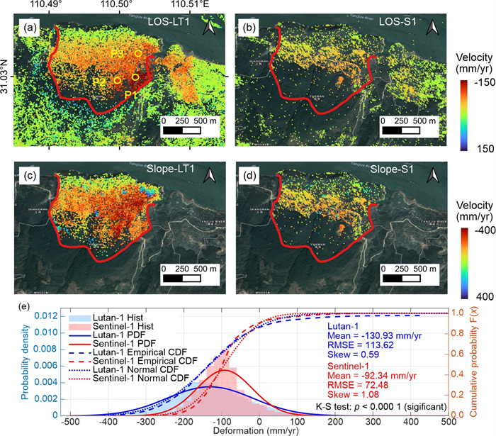
| Zhou, C., Cao, Y., Yin, K. L., et al., 2020. Landslide Characterization Applying Sentinel-1 Images and InSAR Technique: The Muyubao Landslide in the Three Gorges Reservoir Area, China. Remote Sensing, 12(20): 3385. https://doi.org/10.3390/rs12203385 |
| Zhou, C., Ye, M. Y., Zhuge, X., et al., 2025. An Interpretable Attention-Based Deep Learning Method for Landslide Prediction Based on Multi-Temporal InSAR Time Series: A Case Study of Xinpu Landslide in the TGRA. Remote Sensing of Environment, 318: 114580. https://doi.org/10.1016/j.rse.2024.114580 |
Figures(3)
Copyright © 2013-2020 Journal of Earth Science 鄂ICP备15021562号-2
Tel: +86-27-67885075 Fax: +86-27-67885075 E-mail: xbb@cug.edu.cn
Address: Editorial Office of Journal, China University of Geosciences, Yujiashan, Wuhan, Hubei 430074, P. R. China
Supported by:
Beijing Renhe Information Technology Co. Ltd
E-mail:
info@rhhz.net


 DownLoad: