
Citation: | Guangdao Hu, Jianguo Chen, Shouyu Chen. Metallic Mineral Resources Assessment and Analysis System Design. Journal of Earth Science, 2000, 11(3): 308-311. |
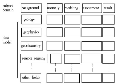
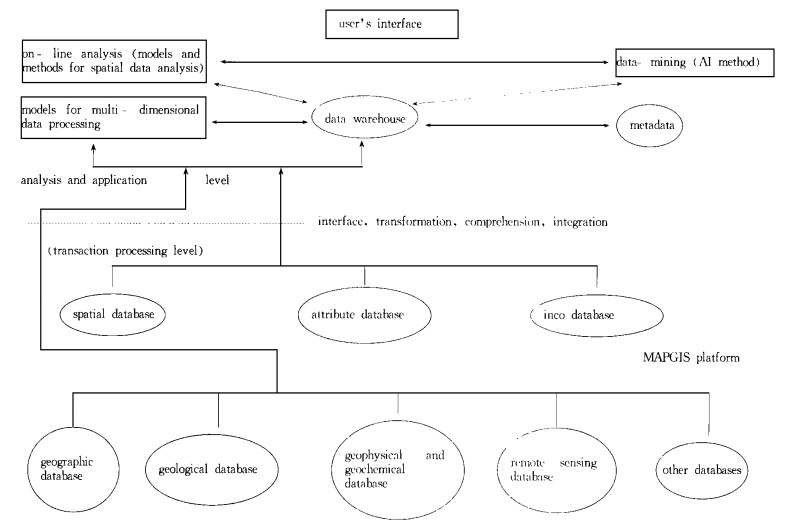
This paper presents the aim and the design structure of the metallic mineral resources assessment and analysis system. This system adopts an integrated technique of data warehouse composed of affairs-processing layer and analysis-application layer. The affairs-processing layer includes multiform databases (such as geological database, geophysical database, geochemical database), while the analysis application layer includes data warehouse, online analysis processing and data mining. This paper also presents in detail the data warehouse of the present system and the appropriate spatial analysis methods and models. Finally, this paper presents the prospect of the system.
The geographic information system (GIS) providing various functions such as spatial data management, graph editing, spatial data analysis and graph or image input and output, has changed the working methods dramatically in the field of geological research. However, due to the difference in objects studied and the methods used, GIS has some shortcomings when used for the geological studies, since GIS was developed specifically for geographic purposes. The development of the special GISis one way to broaden the range of the GIS application. The metallic mineral resources assessment and analysis system, an assembled software system for mineral resources exploration and information management, combines special GIS with data warehouse technique and provides the scheme for integrating the application of GISin basic-level units and the construction of the information engineering in the geological field.
This system, an assembled software system appropriate for the mineral resources exploration assessment and information management, includes the establishment of the norms and standards for multi-geological information system of mineral exploration, special spatial data analysis models and spatial analysis methods, mineral resources exploration assessment, analysis and information management based on the data warehouse technique. This is also an assembled platform of GIS and multi-geological information management, friendly to the geological technicians at the grass-root level. The standardization and normalization of the information are the basis of the information system design, and the premise of ensuring the system compatibility, sharing data, promoting the information exchange and increasing the application efficiency. However, up to now little work has been done on the norms and standards of metallic mineral resources exploration assessment information system, so that the norms and standards of this kind of information system should be planned in detail during the development of this assembled software platform in order to make the system more valuable.
The information engineering system should be constructed at different levels. The design goal of the metallic mineral resources exploration assessment system is to build the information engineering at the grass-root level of the geological exploration community. Using the data warehousing technique, this system can not only efficiently integrate various databases at the grass-root level of the geological exploration community, but also meet the needs of the authorities for the data from the grass-root units. In this way, the information management and decision-making analysis may be obtained at higher level, and the data-sharing weakness characteristic of an ordinary GIS system can be avoided.
In metallic mineral resources exploration assessment, different information resources, spatial, non-spatial, quantitative and qualitative, are processed especially in geology, geophysics, geochemistry, remote-sensing and in the mountainarea projects for the mineral resources exploration. In order to store the varieties of raw information in the various databases mentioned above, and to equip the system with the management and the analysis of all these multi-source, multivariable data, the integrated data-warehousing technique is adopted by the authors. The general structure of this system is shown in Fig. 1.
The whole system is made up of two levels: transaction processing level and analysis and application level. The transaction processing level includes all kinds of raw databases such as geographic database, geological database, geophysical database, geochemical database, remote-sensing database and other field databases. The field database is mainly composed of various detailed databases at the grass-root level, such as the database for deposits and mineral occurrences, the database for mountain-area projects (exploration trench, exploration opening and borehole), the database for geological section, the database for rock and mineral analysis and the database for metallogenetic analysis and testing. In this system, the graphical input and output operation provided by GIS platform, the spatial database, attribute database and icon database associated with the GIS are all included in the affairs processing layer. In other words, this is another basal detailed layer associated with the spatial graphics.
The analysis and application layer is made up of three sections: data warehouse, on-line analysis and processes and data-mining. Based on the data warehouse technique, this layer integrates on-line analysis and processes and data-mining. In the early 1980s, concepts and methods were proposed for integrated database, model database and method database in the research on the decision support system. However, it has been proved in the real situation that such conception is only practical in the demonstration system. Since 1990s, due to the development of the computer sciences, especially that of the database technique, three independent information processing techniques: the data warehouse, the on-line analysis and processing, the data-mining, have been used to solve such problems as data storage and management, data analysis and application and automatic knowledge discovery. Because of the intrinsic correlation and complementation among these three methods, a new frame of decision-making system is created with the following three features: (1) The data warehouse deals with the inconsistency of the data stored in the various databases in this system. In addition, this warehouse can integrate, transform, synthesize and reorganize affair data in the basal databases into the multi-dimension data used for the whole system. In this sense, this warehouse provides the basis for data storage and management. (2) The on-line data analysis and processing start from the integrated data in the data warehouse to construct the analysis-oriented multi-dimensional data model. Then this multi-dimensional analytical Metallic Mineral Resources Assessment and Analysis System Design 309method is employed to analyze and compare the multi-dimensional data from different angles. In this way, the separation of the analytical method from the data structure can be achieved.(3) Based on the data warehouse and the multi-dimensional data model, data-mining is used to discover automatically the potential modes present in the data, and to predict automatically in line with these modes. The mature models may again turn into the on-line analytical method, one of the new development trends in the AI technology.
The main purpose of the analysis and application layer is to improve the exploration and analysis of the metallic mineral resources. The on-line analysis and processing model includes the spatial analysis models and methods for geology, geophysics, geochemistry, remote sensing and comprehensive information, as well as the ordinary functions provided by GIS. Based on the AI methods and ANN (artificial neural network), the data-mining model actualizes the automatic extraction of potential models present in the data.
The data warehouse, a new technique developed in the 1990s, upgrades the database application from the businessprocessing in the past to the support of high-level analytical decision-making process (Cheng et al., 1997; Wang, 1997).
The main factors for the data warehouse design include the mineral resources exploration, the assessment requirement and the multi-source geoscience information management in the metallic mineral resources assessment analysis system. The overall structure was designed according to the main themes and the data models (Fig. 2)
The most important features of the data warehouse are shown below: (1) The data warehouse is oriented toward the subject. The subject is the norm for the classification of data at higher layer. Each subject corresponds to the same analytical field. In addition, each field is independent from any other field because it has its own logical connotation. (2) The data warehouse is integrated. Before the data enter into the data warehouse, the data should be processed and integrated by means of deleting the pure operational or detailed data, and extending the code structure (attribute).
In the metallic mineral resources assessment analytical system, the data warehouse is designed for the mineral resources exploration and assessment and for the management of multi-variable geoscience information. The overall structure of the data warehouse follows the subject domain and data models classified (Fig. 2).
The subject domain is classified as the background, anomaly, modeling, assessment and results with each corresponding to the major features of the different working stages in the exploration and assessment of the mineral resources. At the same time, the analytical method varies with different subject domains. However, the logical connotations in the same subject domain or between different data models may intersect with each other, laying the foundation for the comprehensive analysis of the multi-source information.
The data model is classified as geological model, geophysical exploration model, geochemical exploration model and remote-sensing model. Each data model is definite in physical meaning. No intersection is present between the various models. The data structures of these models vary from each other.
The data models in the data warehouse are further divided into three levels: high-level, middle-level and low-level (Fig. 3). The three-level geological data models in the data warehouse show that the data models of different levels are appropriate for either different precision requirements of the research or for different research purposes. When the geological anomalies are studied and analyzed, the low-level geological data model is used. However, when the regional background is studied and analyzed, the middle-level geological data model is used.
The global multi-dimensional data view is generated in the system structure of the data warehouse. In this case, the users just need retrieve reasonably the multi-dimensional data models and in turn the system will automatically organize all sorts of analysis-oriented data. The users need not operate and manage various data structures in the data warehouse, this simplifies the users' operations of various data.
The data warehouse connected with bottom database via interface synthesizes and integrates the detailed data in the bottom layer into the data of different sizes via different transformation model. These data are thus stored in the various subject domains and data models of the data warehouse, laying the data foundation of the online analysis and processing and data mining.
All sorts of the bottom-layer databases in the affair processing layer (including geographic database, geological database, geophysical database, geochemical database, remote-sensing database, and other field database and GIS-based spatial and attribute databases) provide only data or graphical and image materials for the mineral resources assessment. But they do not reveal the intrinsic principles existing between these materials. In this sense, more researches should be done to develop the spatial analysis methods and models (mineral prospecting models) for the comprehensive analysis of the mineral resources. These mineral prospecting models, together with the dedicated spatial analysis methods, can be employed to analyze, study, extract and optimize the multi-source geological information in geology, geophysics, geochemistry and remote sensing. Therefore, the intrinsic principles can be revealed, the sections favorable for the mineralization can be selected, the resources reserves can be estimated, and finally the mineral resources can be assessed and analyzed. The excellent establishment of the dedicated spatial analysis models and methods characteristic of online analysis and processing for the forecasting of the mineral resources is the key to the test of the application effect of the whole assessment analysis system.
The system design goal is to absorb and use various updated research methods and results under the guidance of the advanced mineral resources exploration theories and mathematical geological methods, to employ the mature practical mathematical methods such as logical reasoning, weighted technique, neural network, fuzzy mathematics and geological statistics for the comprehensive analysis of the geological information. Therefore, the spatial analysis method and spatial analysis model for the exploration and assessment of the mineral resources are studied and established with an emphasis on the optimization and assessment of the prospecting targets in the mineralization zone. (1) The analytical models and methods for the geological backgrounds and geological anomalies (Zhao et al., 1996; Zhao et al., 1991). The geological information can be extracted from the geological body units or grid units. The automatic or man-computer interactive classification of different geological backgrounds can be made by means of such mathematical methods as multi-dimension fraction and neural network. At the same time, the geological backgrounds can be classified and graded. The regional geological anomalies can be obtained from the geological information, and the geological anomalies can be classified and graded. (2) The geophysical and geochemical data analytical model and method. The geological statistics and gravity-magnet field theory are employed to analyze the geophysical and geochemical anomalies, resulting in the zoning and structural analyses in terms of regional geophysics and geochemistry. (3) The remote sensing information analytical model and method. The pattern recognition and wavelet analysis are both employed to analyze the remote-sensing anomalies, and especially the linear and circular structures. (4) The multi-source information comprehensive analytical model and method. This model is used to synthesize the multi-source information, to make overlay and comprehensive anomalous analyses, to establish a comprehensive model for the forecasting of mineral resources, to delineate the target area, to predict and evaluate the resources reserves.
The metallic mineral resources analysis and assessment system is a dedicated system developed for the information engineering at the grass-root level of geological exploration, in line with the practical need of rapid mineral exploration and assessment. The standards and notions of multi-resources geological information system constructed by mineral resources analysis and assessment system are favorable for the association and sharing of geological information in China geological community. The dedicated spatial analysis method and model in this system improves the comprehensive processing of the geoscience information and computerization of the mineral resources assessment. The data warehouse integrates various techniques adopted in this system, realizes the data storage and management, analyzes the knowledge application and discovers automatically the required knowledge. This data warehouse also simplifies the user' s operation, and increases the vitality of the system. In short, the construction of the mineral resources analysis and assessment system, an evidence of the close correlation between research and end products, shortens the cycle of exploration and assessment, improves the exploration standards, and achieves economic benefits.
Cheng W, Deng S, Zhang W, 1997. Summary of Data-Mining and Knowledge Excavating. China Computerworld, 24: 97 |
Wang S, 1997. Data Warehouse and Online Analysis Process and Data-Mining. China Computerworld, 1: 122-123 |
Zhao P, Chi S, Chen Y, 1996. Investigating Geo-anomaly: Basis of Mineral Exploration. Geological Journal of China Universities, 2 (4): 361-373 |
Zhao P, Li Z, Hu G, 1991. Important Mineral Region Deposit Exploration in Three-Dimension-Anhui Yueshan Region for Example. Wuhan: China University of Geosciences Press. 20-25 |