| Citation: | Malogo J M Kongola, Ende Wang. Gold Minerogenetic Prognosis Using Satellite Data: Case Study of Paishanlou Gold Mine, Liaoning Province, China. Journal of Earth Science, 2005, 16(3): 250-255.

|
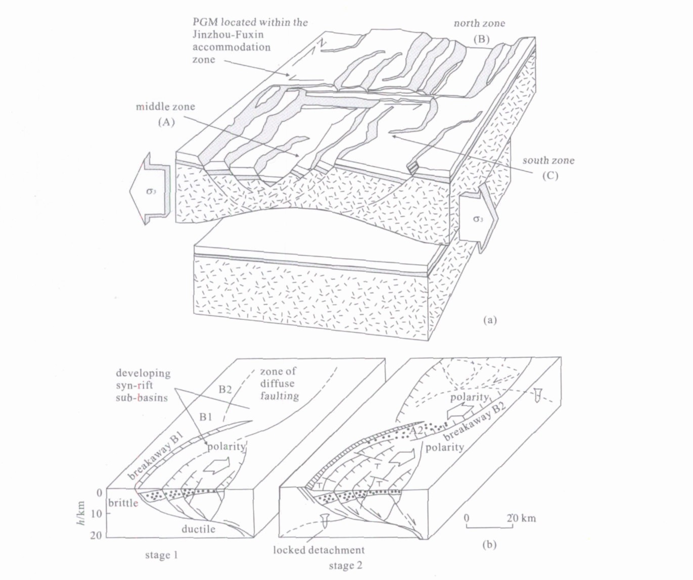
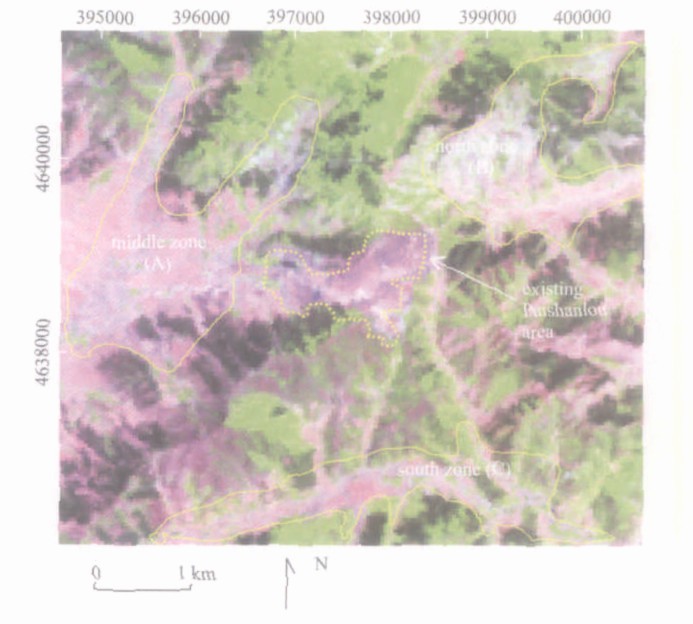
The major scientific goal of using satellite data for mineral prospecting in the study area was two-fold: (a) mapping geology, faults and fractures that localize ore deposits; (b) recognizing hydrothermally altered rocks by interpreting their spectral signatures. The lithology, properties, and geological relations of the rocks were key to understanding such varied phenomena as convection, melting and transport mechanisms, rock deformation and alteration, the sources of magnetic anomalies, and the hydrothermal circulation and formation of gold deposits. Satellite data were enhanced using the following techniques: band combinations, ratios, directional sharpening filtering, Laplacian transform, spatial convolution, and density slicing. By mapping a larger area, the Paishanlou Gold Mine was discovered to be located with in an accommodation zone, with three significant populations of faults having bearings of 95, 145, and 180 degrees. Faults bearing 145 degrees make up the faults of the main shear zone. The faults bearing 180 degrees have large sinistral offsets, typically 1.5 km, and form a synthetic-antithetic set with the faults bearing 145 degrees, which have dextral displacements of tens of meters. In the Landsat ETM+ image composed of bands 7-4-2 RGB, gneiss rocks were clearly seen as red purple, and granitic and plagioclase bodies in pale brown/pink. The strongest alteration signature in the image was found along the detachment fault antiform located closest to the mine and the plutons responsible for the Paishanlou gold mineralization. Satellite image interpretation coupled with field surveys led to the identification of iron mineral composites, hydrothermally altered areas, fractures, and an accommodation zone. These anomalies finally resulted in the discovery of three new gold-mineralized sites.

| Bennett, S. A., Atkinson, W. W., Kruse, F. A., 1993. Use of Thematic Mapper Imagery to Identify Mineralization in the Santa Teresa District, Sonora, Mexico. International Geology Review, 35: 1009-1029. doi: 10.1080/00206819309465572 |
| Bosworth, W., Lambiase, J., Keisler, R., 1986. A New Look at Gregory's Rift: Structural Style of Continental Rifting. American Geophysical Union Transactions, 67: 577-583. doi: 10.1029/EO067i029p00577 |
| Crippen, R. E., 1989. Development of Remote Sensing Techniques for the Investigation of Neotectonic Activity, Eastern Transverse Rangesand Vicinity, Southern California: [Dissertation]. University of California, Santa Barbara. 304. |
| Crippen, R. E., Blom, R. G., Heyada, J. R., 1988. Directed Band Ratioing for the Retention of Perceptually Independent Topographic Expressionin Chromaticity Enhanced Imagery. International Journal of Remote Sensing, 9: 749-765. doi: 10.1080/01431168808954890 |
| Faulds, J. E., Mawar, C. K., Gaisaman, J. W., 1987. Possible Modes of Deformationalong "Accommodation Zones" in Rifted Continental Crust. Geological Society of America Abstracts with Programs, 19: 659-660. |
| Frost, D. M., Heidrick, G., 1996. Tertiary Extensionand Mineral Deposits, Southwestern United States. Society of Economic Geologists, 25: 26-37. |
| Hart, J. C., Goldfarb, R. J., Qiu, Y., et al., 2002. Gold Deposits of the Northern Margin of the North China Craton: Multiple Late Paleozoic Mesozoic Mineralizing Events. Mineralium Deposita, 37: 326-351. doi: 10.1007/s00126-001-0239-2 |
| Kongola, M., Wang, E. D., 2005. Mapping Supergene/Hypogene Alteration Signatures with Landsat ETM+Data: Paishanlou Gold Mine, Liaoning Province, China. Journal of China University of Geosciences, 16 (1): 38-44. |
| Kongola, M., Wang, E. D., Yu, M. X., et al., 2004. Petrologic Characterization of Host Rocks: Case Study of Paishanlou Gold Mine, Liaoning Province, China. Geologyand Resources, 13: 85-95. |
| Paishanlou Gold Mine, 2003. An Introductory Magazine Producedbythe Paishanlou Gold Mine, Liaoning, China. 14 |

Figures(4)
Copyright © 2013-2020 Journal of Earth Science 鄂ICP备15021562号-2
Tel: +86-27-67885075 Fax: +86-27-67885075 E-mail: xbb@cug.edu.cn
Address: Editorial Office of Journal, China University of Geosciences, Yujiashan, Wuhan, Hubei 430074, P. R. China
Supported by:
Beijing Renhe Information Technology Co. Ltd
E-mail:
info@rhhz.net


 DownLoad: