
Citation: | Yangquan Jiao, Jiaxin Yan, Sitian Li, Ruiqi Yang, Fengjiang Lang, Shengke Yang. Character of Terrestrial Sequence Stratigraphy and Depositional System in Incised Valley, Outcrop Area of Karamay Oilfield, Junggar Basin, China. Journal of Earth Science, 2004, 15(3): 324-334. |
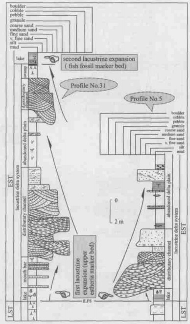
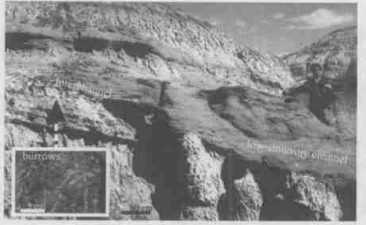
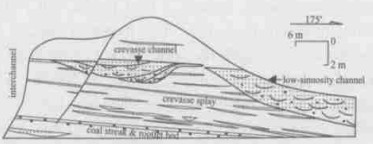
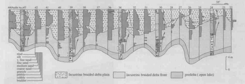
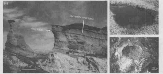
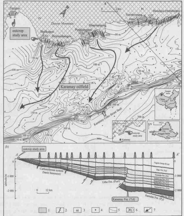
In the Karamay oilfield located on the northwestern margin of Junggar basin, Xinjiang, China, a large area of the Karamay Formation is exposed at outcrop in the northeast of the oilfield, a consequence of thrusting. The Middle Triassic Karamay Formation in the outcrop area is a type of terrestrial third-order sequence, bounded by two easily recognizable sequence boundaries: a regional surface of angular unconformity (SB1) at the base and a regional unconformity (SB2) at the top. Within the Karamay Formation, two lacustrine expansion events can be recognized and be used to identify both the initial and the maximum lacustrine flooding surfaces. The two lacustrine flooding surfaces serve as references for the classification of this third-order sequence-Karamay Formation into the following three sedimentary successions: a lower lowstand systems tract (LST), a middle lacustrine-expanding systems tract (EST), and an upper highstand systems tract (HST). Different systems tracts are composed of different depositional system assemblages. In this paper, each depositional system is described in detail. The lowstand systems tract in the study area is characterized by incised valleys. At the base and on the margin of the incised valleys occur alluvial fan depositional systems, and in the upper and distal parts of the alluvial fan, low-sinuosity river depositional systems. The lacustrine-expanding systems tract consists of a lacustrine depositional system and a lacustrine delta depositional system, overlying the lower incised valley fills. The highstand systems tract is filled by a widespread lacustrine braided delta depositional system. The analysis of sequence stratigraphy in this paper serves the description of the spatial distribution of the reservoir. The depositional system analysis serves the description of the reservoir types. Field investigations of oil sandstone and oil seepage show that the Karamay Formation is composed of several types of reservoirs. However, two types of high quality reservoir occur both in the upper interval of the lowstand systems tract and in the lacustrine-expanding systems tract: gravelly low-sinuosity channel in the distal fans and sandy-gravelly distributary channel in the lacustrine delta plain.
The Karamay oilfield was discovered in 1955, its Middle Triassic Karamay Formation is considered to be one of the major reservoirs (Zhang, 1995). After over 40 years' extraction, in this reservoir, petroleum occurs with as much as 65 % complex water out of oilfield, and the recovery efficiency of the commercial reserves reaches around 75 % (Chen, 1991; Zhao, 1989). Therefore, the fundamental stratigraphic structure of the Karamay Formation and the structural types of reservoir must be more precisely defined in order to stabilize oil production and to extract remaining oil. The authors made an attempt to solve this problem by fully using outcrop area near the oilfield. Karamay Formation was exposed over a large outcrop area, northeast of the Karamay oilfield (Yang and Guo, 1989), there were only two fundamental geological investigations in 1951-1952 and 1964-1965. Actually, 46 relatively complete profiles and a large number of oil sandstones and oil seepages (Fig. 1) have been investigated in this outcrop area, they are natural laboratories for solving the problems mentioned above.
The Karamay oilfield is located on the northwestern margin of the Mesozoic Junggar basin, a large continental sedimentary basin. Petroleum and gas exploration during the past several years indicated that a large-scale thrust fault system occurred on the northwestern margin of the Junggar basin (Obukhov, 2000; Lawrence, 1990; Peng and Zhang, 1989; Taner et al., 1988; You, 1986; Wu et al., 1985; Peng et al., 1984).
Thrusts controlled the centers of subsidence and sedimentation in the basin, mainly reflected in a conspicuous difference in thickness between the hanging wall and footwall of fractures in such formations as the Urho Formation (P2ur), Karamay Formation (T2k), Baijiantan Formation (T3b), Badaowan Formation (J1b), Sangonghe Formation (J1s), Xishanyao Formation (J2x) and Toutunhe Formation (J2t) (Fig. 1).
Thrust fractures also controlled the development of oilfields. The cessation of thrusting at the end of the Middle Jurassic made the Qigu Formation (J3q) and Tugulu Group (K1tg) overlie the fractures, giving rise to excellent structures for hydrocarbon accumulation. On the northwestern margin of the Junggar basin, a series of oilfields, such as the Chepaizi oilfield, Hongshanzui oilfield, Karamay oilfield, Baikouquan oilfield, Urho oilfield, Fengcheng oilfield and Xiazijie oilfield, occurred along the fracture zone (Xie et al., 1988; You, 1986; Tan, 1985; Wu et al., 1985).
The target strata (the Middle Triassic Karamay Formation) for this study extend from the oilfield into the outcrop study area (Fig. 1). In the outcrop area, the Karamay Formation directly oversteps a basin basement composed of Carboniferous system (with the largest stratigraphic thickness of only 88 m).
The Karamay Formation, a typical continental (non-marine) third-order sequence, is characterized by its easily recognized sequence boundaries and lacustrine flooding surfaces that may be used to divide the third-order sequence further into systems tracts.
In the outcrop area, the Karamay Formation ranges between 16 and 88 m in thickness with its base and top bounded by unconformities (Fig. 2). The sequence boundary at the base, located between the Karamay Formation and the Carboniferous system (the basin basement), is a surface of regional angular unconformity, called sequence boundary 1 (SB1). The SB1 is easy to recognize, because the Karamay Formation has not been affected by metamorphism, while the Carboniferous system has undergone low degree metamorphism. The sequence boundary at the top, located between the Karamay Formation and the Baijiantan Formation is a regional surface of unconformity, called sequence boundary 2 (SB2). The SB2 is also easy to recognize because the sediments in the Karamay Formation are relatively coarse-grained sandstone and conglomerate, but those in the Baijiantan Formation have graded into fine-grained lacustrine mudstone and siltstone.
In the outcrop area, two lacustrine expanding events are recorded in the Karamay Formation. The first lacustrine expanding event in the relatively thin middle-to-lower interval of the Karamay Formation was recorded only in Profile No. 4, Profile No. 14 and Profile No. 31 whose lacustrine mudstone was 1 m thick. In the sediments of this event, only a small number of fossils have been found such as Kazacharthra, insects and estheria (e.g. Palaeolinmadiopsis sp., Liograpta sp., Brachyestheria sp., Pseudestheria brodienana), which can be correlated with the "upper estheria marker bed" of the oilfield (Fig. 3). This lacustrine expanding event is recorded largely in the hinterland of the basin. The second lacustrine expanding event affecting the whole outcrop area occurred in the middle-to-upper interval of the Karamay Formation, with its very stable thicknesses averaging only 4.2 m. The sediments in this event contain abundant Kazacharthra (e.g. Almatium gusevi, A. Elongatumm, A. Subquadrata, A. sp., Zhungarium cardiforme, Z. Karasuense, Z. sp.), insects (e.g. Ademosynoides sp., Sinonitidulina liufouensis, S. sp., Mesorthophlebia sp., Cutitegnemena oonis, C. sp., Hukouscytna sp., Triassoblatta sp.), water grass and fish (Fig. 4) that can be correlated with the "fish fossil marker bed" of the oilfield. The growth sequence and affected range of the lacustrine expanding events can serve as a reference for the identification of initial lacustrine flooding surface (Fig. 3) located at the base of the sediments from the first lacustrine expanding event and of maximum lacustrine flooding surface (Fig. 5) located at the top of the sediments from the second lacustrine expanding event.
The lacustrine flooding surface and its correlative surface can all be used to classify the Karamay Formation as three systems tracts as shown in Figs. 2 and 5: (1) a lowstand systems tract, (2) a lacustrine-expanding systems tract and (3) a highstand systems tract. The lowstand systems tract, 0-58 m thick, located between SB1 and initial lacustrine flooding surface, is mainly composed of an alluvial fan depositional system and a low-sinuosity river depositional system of distal-fan. However, these two depositional systems occur mainly in a series ofincised valleys. The lacustrine-expanding systems tracts, 5-18 m thick, located between the initial and maximum lacustrine flooding surfaces, are composed mainly of a lacustrine depositional system and a delta depositional system. The highstand systems tract, located between the maximum lacustrine flooding surface and SB2, is dominated by braided delta deposition, 12-21 m thick.
In the study area, according to the 46 profile lines, it can be found that the lowstand systems tract is controlled by five incised valleys overlying the thrust sheet on the margin of the basin and perpendicular to the strike of the Zhayier Mountain (Fig. 2).
The five incised valleys follow the following order from northwest to southeast: Tuzigou incised valley, Shuikugou incised valley, Heiyoushangou incised valley, Pinglianggou-Huayuangou incised valley, Shendigou-Dazhuluogou incised valley. In particular, the largest Shendigou-Dazhuluogou incised valley is the earliest incised valley filled with sediments (Fig. 2). The stratigraphic thickness distribution pattern shown in Fig. 1 suggests that this largest-scale incised valley spans the Karamay-Urho thrust fracture in the southern direction into the hinterland (center) of the basin.
An alluvial fan depositional system occurs widely along the bases and on the margins of incised valleys (Figs. 2 and 5). The alluvial fan depositional system is composed of debris flow sediments and red mudstone. The debris flow sedi-ments are massive, and contain a mixture of different sizes of detritus grains. The diameter of the gravel reaches as large as 80 cm, but is usually 10-20 cm. In addition, the complex composition of the detritus includes quartz gravel, volcanic gravel, metamorphic rock gravel, igneous rock gravel, and a large volume of mudstone gravel (Fig. 6). The red mudstone is a kind of relatively low-energy alluvial-fan sediments formed in the inter-flooding stage. The early research showed that the Karamay Formation was composed mainly of alluvial fan sediments (Zhang, 1995; Chang, 1981). However, the present research in the outcrop area indicates that several kinds of depositional systems are present in the Karamay Formation, for example, a low-sinuosity river depositional system in distal fan.
The low-sinuosity river depositional system is located in the top and distal parts of the alluvial fan depositional system with its basal boundary conspicuously time transgressive, and its top boundary serving as the initial lacustrine flooding surface and its correlative surface (Figs. 2 and 5). The separation of the low-sinuosity river depositional system from the alluvial fan system is mainly attributed to the following five features. (1) This system, of relatively large scale, occupies mainly the vast area of the middle-to-upper intervals of the incised valley (Fig. 2). (2) This system is composed of low-sinuosity channels and interchannels (Fig. 7). The presence of rare gravity flows and of thinned-debris-flow sediments 40 cm thick in the Shendigou incised-valley only shows that this depositional system, located in the distal parts of the alluvial fan, is closely associated with the alluvial fan depositional system. (3) The low-sinuosity channel, the nucleus of this system, is around 24 m wide, around 2.8 m thick, and 100-300 m in channel spacing. The major lithologies of the channel include large-scale trough cross-bedding granule conglomerate and gravelly sandstone. The sediments are relatively well sorted. This channel is a highly significant part of the reservoir of the Karamay oilfield that can be observed at outcrop (Fig. 7). (4) This kind of channel, capable of violent downward cutting, has scoured the interchannel sediments to a great extent, resulting in many channel lags. The scouring surface at the base of the channel is uneven. In particular, the downward cutting magnitude of the scour grooves located on a part of the scouring surface may reach 1.5 m, indicating that the channel is of low sinuosity. (5) Relatively large-scale interchannels, occupying nearly half of the volume of the low-sinuosity river depositional system, are composed mainly of dark red, gray green fine-grained sediments. In these interchannel depressions, there are extremely well developed animal burrows and small-scale marshes, suggesting that the paleo-climate was relatively humid. In addition, some crevasse channels and crevasse splays are also present near the channel, a rare phenomenon (Fig. 8).
Two major lacustrine expanding events were recorded in the lacustrine-systems tract. The first lacustrine expansion gave rise to a lacustrine delta depositional systems, and the second one to a regional lacustrine depositional system.
The lacustrine delta depositional system is composed mainly of the products of predelta, delta front and delta plain sediments (Fig. 3). However, delta plain sediments dominate the lacustrine delta sediments because of the limited effect of the first lacustrine expansion (Fig. 9).
The predelta sediments and the delta frontal sediments were recorded mainly in Profiles No. 5, No. 14 and No. 31. The predelta sediments are composed of a minority of dark-colored mudstone with fresh-water animal fossils and local horizontal bedding. The delta frontal sediments are composed mainly of sheet-like mouth bar sand and lacustrine delta frontal mud (Fig. 3).
The majority of the outcrop area is composed of delta plain sediments. With the distributary channel serving as the center, the delta plain sediments are classified as a distributary channel filling association, distributary channel margin association, and interdistirbutary bay association.
The distributary channel filling association includes the distributary channel and abandoned channels. (1) The distributary channel, the framework of this system, is usually over 90 m wide and over 5 m thick. The base of the distributary channel is associated with an obvious downward-cutting scouring surface often overlying a great number of channel lags. The channel is composed largely of coarse-grained trough cross-bedding bodies of granule conglomerate, gravelly sandstone, and sandstone with various kinds of grains (Fig. 9). The textural maturity and the compositional maturity of the distributary channel sediments both greatly increase by a great margin, compared with those of the low-sinuosity channel of the lowstand systems tract. However, the grain size of the sediments becomes finer. Vertically, the sand body of the distributary channel exhibits an upward-thinning positive rhythm (Fig. 3). (2) The abandonment process of an abandoned channel is often defined as the following two forms: one is the gradual upward development of the distributary channel into alternate layers of sandstone and mudstone (this is gradual abandonment), the other is sudden abandonment where the base of the channel has been scoured with the scouring surfaces filled with semi-lenticular mudstone or siltstone (Fig. 10).
The marginal association of the distributary channel includes three genetic facies: natural levee, crevasse splay and crevasse channel. (1) The natural levee sediments, located on the upper interval on margins of the distributary channel, exhibits a prominent upward structure around 0.6 m thick, consisting of alternate layers of sandstone and mudstone. In the direction of the interdistributary bay, the grain size of the sediments thins out distinctively (Fig. 11). (2) Another commonly-seen kind of genetic facies is a crevasse splay often less than 1.5 m thick that gradually becomes thinner in the direction of the interdistributary bay. As the paleocurrent energy becomes higher and higher, the crevasse splay hasgradually graded into thick-layered massive granule conglomerates and gravelly sandstones (Fig. 9). (3) Persistent crevasse development results in a crevasse channel usually less than 2 m wide and less than 0.8 m thick, consisting of granule conglomerates (Fig. 9). The interdistributary bay, a depression, has been reconstructed by several kinds of deposition during flood seasons. Such reconstructions occur as crevasse and overbank erosion in inter-flooding seasons. However, the reconstructions are dominated by suspension deposition and biological effects. Therefore, the interdistributary bay is widely associated with several kinds of genetic facies such as crevasse channel, crevasse splay, muddy sediments containing animal burrows and frequently-occurring carbonaceous marshes (Fig. 9).
The lacustrine depositional system, a consequence of the second regional lacustrine expansion spreading over the whole study area, is composed of marginal lake sediments and open lake sediments. The marginal lake sediments, composed of fine-grained sands, silts and muds, show the following three distinctive features: (1) widely-developing Skolithos, (2) locally-developed wave ripples, and (3) plant roots and trunk fossils. The open lake sediments 4-6 m thick are composed largely of gray mudstones with horizontal beddings. Along the surface of the layer occur massive Kazacharthra, insects, water grass and fossil fish. The membranes and wings of the insects are well preserved, indicating the existence of calm hydrodynamic environment (Fig. 4).
The incised valley continues to fill until the second lacustrine expansion. Therefore, the lowstand systems tract and the lacustrine-expanding systems tract of the Karamay Formation at outcrop result in the filling and gradual onlapping.
Immediately following the second regional lacustrine expansion, a large lacustrine braided delta is formed, resulting in the highstand systems tract (Figs. 2 and 5). The lacustrine braided delta is illustrated in the following four aspects (1) This system shows a typical upward-coarsening vertical sequence at outcrop. (2) No gravity flow sediments have been found in this system. (3) The delta plain of this system, over 1 700 m wide, is composed largely of braided distributary channels 6 m thick on average (Fig. 12). The braided distributary channels can be classified as three types: gravelly braided distributary channels, sandy braided distributary channels and abandoned channels. The gravelly braided distributary channels, relatively large-scale and usually located at the base of a delta plain, are composed mainly of cobbles, pebbles, granules and gravelly sands. Inside the channel occur both distinct and less distinct large trough cross beds. The sandy braided distributary channel, small-scale and usually located over a gravelly braided distributary channel, is composed mainly of trough cross-bedding coarse-grained sands and gravelly sands. The abandoned channels, rarelyseen, are composed of muds and silts. (4) The deltafront of this system is associated with the mouth bar sand body consisting of gravelly sands and coarse-grained sands (Fig. 13). The mouth bar sand body, sheet-like in appearance and characterized by ripples resulting from the balanced waves on the surface, alternates with mud in the delta front.
Sequence stratigraphic analysis serves as the description of the spatial distribution of reservoirs. Depositional system analysis serves as a classification principle for the genetic classification of reservoirs.
The outcrop study area in this paper was once part of the Karamay oilfield. Tectonic movements that occurred later seriously denuded the petroleum reservoirs in the Karamay oilfield (Yang and Guo, 1989). Large-scale oil sandstones and oil seepages at the outcrop provided a sufficient condition for the direct identification of reservoirs (Fig. 14). The overall investigation into the outcrop area reveals the following four types of sedimentary bodies constituting reservoirs in the Karamay Formation. (1) Low-sinuosity channel sandstones located in the lowstand systems tract. As shown in Fig. 7, the gravelly low-sinuosity channel is oil sandstone. (2) Distributary channel sandstones of the lacustrine delta plain located in the lacustrine-expanding systems tract. The sandstone in the right lower part of Fig. 10, the sandstone in the left part of Fig. 11, and the sandstone in Fig. 14 are all such oil sandstones. (3) Mouth bar sandstones of the braided delta front located in the highstand systems tract. (4) Sandy braided distributary channels of the braided delta plain located in the highstand systems tract, for example, the sandy braided channel in the middle part of Fig. 13.
Although the four kinds of sandstones mentioned above contain oil, they should not all be considered to be excellent reservoirs. The sandstones of the low-sinuosity channel and of the distributary channel are the best reservoirs of the four reservoirs, because these oil sandstones at outcrop are numerous and large-scale in the Karamay Formation. However, the oil sandstones at mouth bar, less than 50 cm thick, are not included in ideal reservoirs. In addition, the oil sandstones in the sandy braided distributary channel, limited in scale, are also not included in ideal reservoirs.
The fine-grained sediments located in the areas surrounding the reservoirs mentioned above included interchannel sediments, predelta sediments, interdistributary bay sediments and lacustrine sediments. All these sediments serve as caprocks and intercalated beds. Debris-flow sediments in the alluvial fan system and the gravelly braided distributary channels in the braided delta depositional system have constituted isolated layers because of occurrence of abundant matrixes.
The Karamay Formation at the outcrop of the Karamay oilfield, a typical continental (non-marine) three-order sequence, contains an easily recognized exterior boundary (unconformity surface) and interior boundaries (initial lacustrine flooding and maximum lacustrine flooding surfaces). The two interior boundaries are used to divide the Karamay Formation further into three systems tracts: a lowstand systems tract, a lacustrine-expanding systems tract and a highstand systems tract. The lowstand systems tract, controlled by a series of incised valleys, is composed of an alluvial fan depositional systems and a low-sinuosity river depositional systems. The sandstone of the low-sinuosity channel constitutes a high quality reservoir. The lacustrine-expanding systems tract is composed of a lacustrine delta depositional system and a lacustrine depositional system. The distributary channel sandstone of the delta plain is also a high quality reservoir. The highstand systems tract is composed of a braided delta depositional system. The analysis of sequence stratigraphy and that of the depositional systems are favorable for the identification of high quality reservoir types at outcrop.
ACKNOWLEDGMENTS: This research is funded by the Institute of Petroleum Exploration and Development, Xinjiang Petroleum Administration Bureau, China. Sincerely thanks Xinjiang Institute for their financial support, field cars, and all the sample tests. A. Carroll, John C. Lorenz, M. H. Feeley, N. Hurley and Liangmiao (Scott) Ye critically reviewed an earlier version of the manuscript. Careful language reviews by Feng Guanghua and Roger Mason improved the manuscript.Chang, C., 1981. Alluvial-Fan Coarse Clastic Reservoirs in Karamay. In: Mason, J. F., ed., Petroleum Geology in China. Pennwell Books, Tulsa. 154-170 |
Chen, G., 1991. Division of the Development Phases of Karamay Conglomeratic Oil Reservoir and Its Production Pattern of the Third Development Phases. Xinjiang Petroleum Geology, 12(1): 71-80(in Chinese with English Abstract) |
Lawrence, S. R., 1990. Aspects of the Petroleum Geology of the Junggar Basin, Northwest China. Geological Society Special Publications, 50: 545-557 doi: 10.1144/GSL.SP.1990.050.01.33 |
Obukhov, A. N., 2000. Manrak Upthrust-Overthrust Zone in Zaysan Depression and Its Oil-Gas Potential. Petroleum Geology, 34: 89-93 |
Peng, Z., Chen, X., Zhou, Q., et al., 1984. Genetic Mechanism and Accumulation of Oil and Gas of the Karamay-Urho Fault Zone in the Northwestern Margin of the Junggar Basin. In: Su, Z., ed., Developments in Geoscience; Contribution to the 27th International Geological Congress. Sci. Press, Beijing. 611-620 |
Peng, X., Zhang, G., 1989. Tectonic Features of the Junggar Basin and Their Relationship with Oil and Gas Distribution. In: Zhu, X., ed., Chinese Sedimentary Basins. Elsevier Sci. Publ., Amsterdam. 17-31 |
Taner, I., Kamen, K. M., Meyerhoff, A. A., 1988. Petroleum in the Junggar Basin, Northwestern China. Journal of Southeast Asian Earth Sciences, 2: 163-174 doi: 10.1016/0743-9547(88)90027-X |
Tan, S., 1985. Overthrust Belts in Northwest China and Their Petroleum Trap Types. Oil & Gas Geology, 6(2): 179-186(in Chinese with English Abstract) |
Wu, Z., Wang, S., Ka, M., 1985. General Situation of Natural Gas in Karamay-Urho(Kelamayi-Wuerhe) Oil and Gas Region of Xinjiang Uygur Autonomous Region. Natural Gas Industry, 5(4): 12-16(in Chinese with English Abstract) |
Xie, H., Zhao, B., Lin, L. D., et al., 1988. Oil-Bearing Features along the Karamay Overthrust Belt, Northwestern Junggar Basin, China. In: Wagner, H. C., Wagner, L. C., Wang, F. H., et al., eds., Petroleum Resources of China and Related Subjects. Houston, Circum-Pacific Council for Energy and Mineral Resources, Earth Science Series, 10: 387-402 |
Yang, R., Guo, H., 1989. Analysis of Geologic Characteristics and Origin of the Heavy Oil Reservoirs in the Northwest Margin of Junggar Basin. Xinjiang Petroleum Geology, 10(1): 55-60(in Chinese with English Abstract) |
You, Q., 1986, Geomechanical Analysis and Hydrocarbon Accumulation of the Karamay Overthrust Belt. Oil & Gas Geology, 7: 386-394(in Chinese with English Abstract) |
Zhang, J., 1985, Some Depositional Characteristics and Microfacies Subdivision of Coarse Clastic Alluvial Fans. Acta Sedimentologica Sinica, 3(3): 75-85(in Chinese with English Abstract) |
Zhang, J., 1995. Oil and Gas in the Junggar Basin, the People's Republic of China. AAPG Bulletin, 79: 1258 |
Zhang, J., 1998. Petroleum Exploration of Alluvial Fans in Junggar Basin, Proceedings—World Petroleum Congress. John Wiley & Sons., Chichester. 2: 74-75 |
Zhao, L., 1989, Characteristics of Reservoir Types in Karamay-Baikouquan Oil Field Areas and Tendency of Development. Xinjiang Petroleum Geology, 10(2): 1-7(in Chinese with English Abstract) |