| Citation: | Chun-fang KONG, Kai XU, Chong-long WU. Classification and Extraction of Urban Land-Use Information from High-Resolution Image Based on Object Multi-features. Journal of Earth Science, 2006, 17(2): 151-157.

|
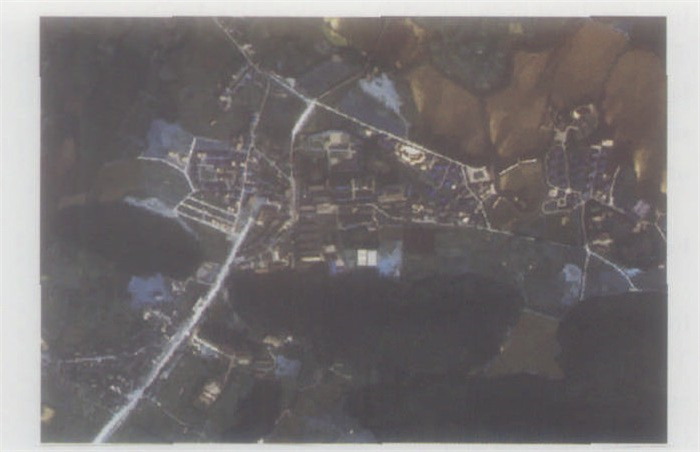
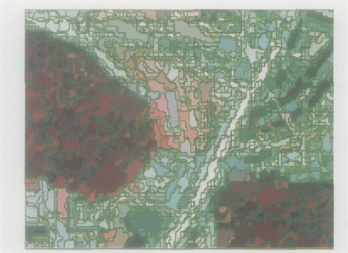
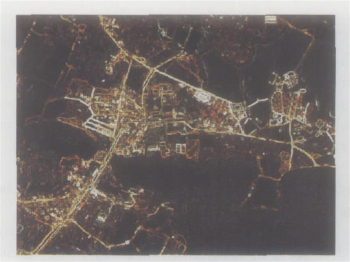
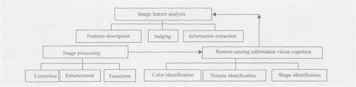
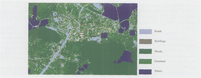
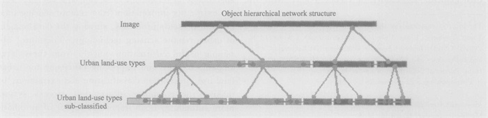
Urban land provides a suitable location for various economic activities which affect the development of surrounding areas. With rapid industrialization and urbanization, the contradictions in land-use become more noticeable. Urban administrators and decision-makers seek modern methods and technology to provide information support for urban growth. Recently, with the fast development of high-resolution sensor technology, more relevant data can be obtained, which is an advantage in studying the sustainable development of urban land-use. However, these data are only information sources and are a mixture of "information" and "noise". Processing, analysis and information extraction from remote sensing data is necessary to provide useful information. This paper extracts urban land-use information from a high-resolution image by using the multi-feature information of the image objects, and adopts an object-oriented image analysis approach and multi-scale image segmentation technology. A classification and extraction model is set up based on the multi-features of the image objects, in order to contribute to information for reasonable planning and effective management. This new image analysis approach offers a satisfactory solution for extracting information quickly and efficiently.

| Aplin, P., Atkinson, P., Curran, P., 1999. Per-field Classi-fication of Land Use Using the Forthcoming Very FineReso1ution Satellite Sensors: Problems and Potential So-lutions. In: Advances in Remote Sensing and GIS Analy-sis. Wiley & amp; Son, Chichester. 219 -239. |
| Blaschke, T., Lang, S., Lorup, E., et al., 2000. Object-Oriented I mage Processing in an Integrated GIS/RemoteSensing Environment and Perspectives for Environmental Applications. Environmental Information for Planning, 2: 555 -570. |
| Blashke, T., Strobl, J., 2001. What' s Wrong with Pixels?Some Recent Developments Interfacing Remote Sensingand GIS. GeoBIT/GIS, 6: 34 -39. |
| Chen, Q. X., Luo, J. C., Zhou, C. H., et al., 2004. Clas-sification of Remotely Sensed I magery Using Multi-features Based Approach. Journal of Remote Sensing, 8 (3): 239 -245 (in Chinese with English Abstract). |
| Foody, G., 1999. I mage Classification with a Neural Net-work: From Completely-Crisp to Fully Fuzzy Situations. Advances in Remote Sensing and GIS Analysis. Wiley & Son, Chichester. 17 -37. |
| Gore, A., 1998. The Digital Earth: Understanding Our Planetin the 21st Century. Calfifornia Science Center, California. |
| Huang, H. P., Wu, B. F., Fan, J. L., 2003. Analysis tothe Relationship of Classification Accuracy SegmentationScale I mage Resolution. IEEE Trans. IGARSS, Ⅵ: 3671 -3673. |
| Lobo, A., Chic, O., Casterad, A., 1996. Classification ofMediterranean Crops with Multisensor Data: Per-pixelversus Per-object Statistics and I mage Segmentation. International Journal of Remote Sensing, 17: 2358 -2400. |
| Luo, J. C., Leung, Y., Zhou, C. H., 1999. Scale SpaceBased Hierarchical Clustering Method and Its Applicationto Remotely Sensed Data Classification. Acta Geodaeticaet Cartographica Sinica, 28 (4): 319 -324 (in Chinesewith English Abstract). |
| Maselli, F., Rudolf, A., Conese, C., 1996. Fuzzy Classifica-tion of Spatially Degraded Thematic Mapper Data for theEsti mation of Sub-pixel Components. International Journal of Remote Sensing, 17: 537 -551. doi: 10.1080/01431169608949026 |
| Mauro, C., Eufemia, T., 2001. Accuracy Assessment of Per-field Classification Integrating Very Fine Spatial Resolu-tion Satellite I magery with Topographic Data. Journal of Geospatial Engineering, 3 (2): 127 -134. |
| Ming, D. P., Luo, J. C., Zhou, C. H., et al., 2005. Infor-mation Extraction from High Resolution Remote SensingI mage and Parcel Unit Extraction Based on Features. Journal of Data Acquisition & Processing, 20 (1): 34 -39 (in Chinese with English Abstract). |
| Skidmore, A., Turner, B., Brinkhof, W., E, et al., 1997. Performance of Neural Network: Mapping Forests UsingGIS and Remotely Sensed Data. ISPRS Journal of Photogrammetric Engineering & Remote Sensing, 63: 501 -514. |
| Zhou, C. H., Luo, J. C., Yang, C. J., et al., 2001. Geographical Understanding and Analyses of RemotelySensed I magery. Science Press, Beijing (in Chinese). |
Figures(7) / Tables(4)
Copyright © 2013-2020 Journal of Earth Science 鄂ICP备15021562号-2
Tel: +86-27-67885075 Fax: +86-27-67885075 E-mail: xbb@cug.edu.cn
Address: Editorial Office of Journal, China University of Geosciences, Yujiashan, Wuhan, Hubei 430074, P. R. China
Supported by:
Beijing Renhe Information Technology Co. Ltd
E-mail:
info@rhhz.net


 DownLoad: