
Citation: | Qiuhai Fan, Xiuxiang Lü, Minghui Yang, Huiwen Xie. Influence of Salt Beds on the Segmentation of Structure and Hydrocarbon Accumulation in Qiulitag Structural Belt, Tarim Basin, China. Journal of Earth Science, 2008, 19(2): 162-173. |
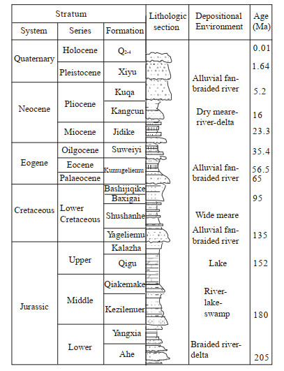
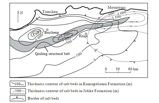
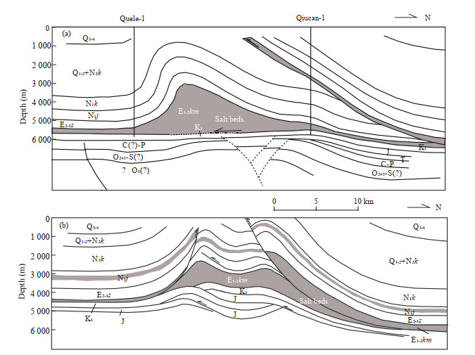
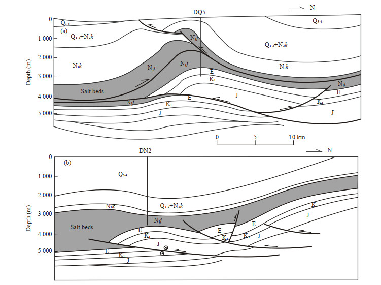
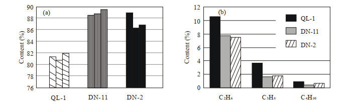
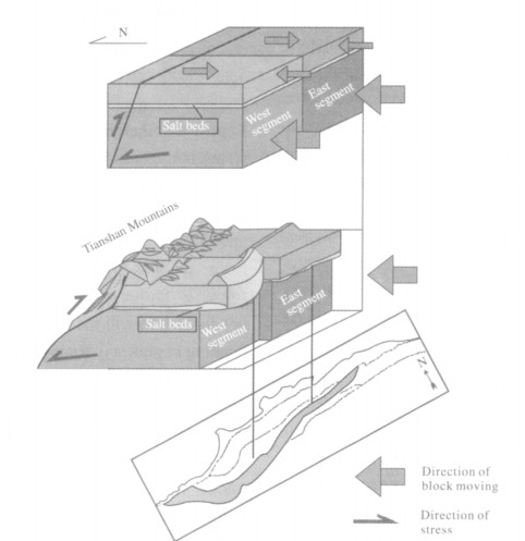
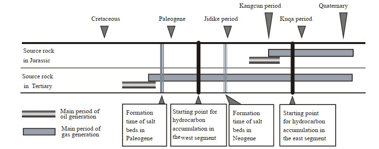
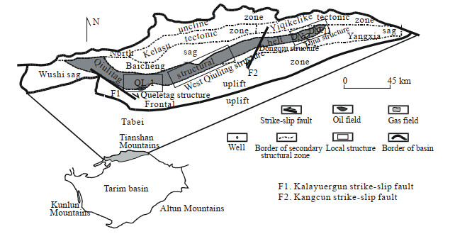
Seismic information and balanced profile technology were used to reveal the influence of the salt bed in segmentation of structure and hydrocarbon accumulation in Qiulitag structural belt in Tarim basin. From west to east, the shortening of strata above the salt beds gradually decreases, while, the shortening below the salt beds gradually increases, which shows that the segmentation of structure integrated the seismic profile. There is great difference of the deformation of strata below and above the salt beds between the west segment and the east segment. The analysis of the distribution of oil/gas fields and the hydrocarbon properties indicates the similar segmentation to the structure segmentation. The salt beds in relatively shallow layers change the stress condition from basement of Kuqa foreland basin, which leads to the segmentation of Qiulitag structural belt. Because the salt beds in the west segment came into being earlier than those in the east segment, the west segment captures hydrocarbon from two sets of source rock, while the east segment can only capture hydrocarbons from one set of source rock. So, the salt beds play an important role in the segmentation of structure and hydrocarbon accumulation.
The Qiulitag structural belt is located in the north Tarim basin, and is the frontal zone of the Kuqa foreland basin (Fig. 1) which is formed by the collision and compression between Tianshan plate and Tarim plate.The Kuqa foreland basin lies between the Tianshan orogen in the north and the Tabei uplift in the south, and came into being in the Miocene (Jia et al., 2003).
As a lineament of approximately east-west strike, the Qiulitag structural belt extends about 300 km from west to east.This structural belt is separated into west and east segments, and the Kuqa River is the cutting point (Fig. 1).The first commercial oil discovery in the area was made in the Quele-1 (QL-1) well in the west segment in 2001, and the first condensate oil/gas field was found in the Dina-2 (DN-2) well in the east segment in 2002.
Despite the occurrence of several thrust faults, a complete stratigraphic sequence was drilled (Fig. 2), including the Quaternary (Q), the Late Tertiary Kuqa (N2k), Kangcun (N1-2k) and Jidike (N1j) formations, the Early Tertiary Suweiyi (E2-3s) and Kumugeliemu (E1-2km) formations, the Cretaceous (K) and the Jurassic (J) formations.
In this area, there are two sets of massive salt beds, one is found in the Eogene formation and the other is found in the Neocene formation.The existence of the salt beds influences not only the formation of structure but also the distribution of hydrocarbons in the Qiulitag structural belt.Based on a clear description of structural style and hydrocarbon accumulation, the process of the formation and segmentation of the Qiulitag structural belt is interpreted and the cause for the differential accumulation of hydrocarbon is given.
In this area, the segmentation of surface structures and subsurface structures is very manifest, caused by the Kangcun strike-slip fault in the middle.The upper end of the Kangcun strike-slip fault breakthroughs the shallow layers, and in the deep end, the fault cuts down into the underlying Jurassic coal beds, forming a flower structure (Fig. 3).
The segmentation of the Qiulitag structural belt is caused by the segmentation of the Kuqa foreland basin In the Cenozoic, the collision of Indian plate and Asian plate led to a considerable area of deformation in inner Asia.Then Kazakhstan plate and Tarim plate collided, which led to the closure of ancient Asian ocean and the formation of fold and uplift in the end of the Late Carboniferous.Because of the structural load caused by the upheaval of orogenic belt and the neighboring land, lithosphere flexural deformation led to the formation of foreland basins, the Kuqa foreland basin in southern Tianshan Mountains and the Junggar basin in northern Tianshan Mountains, flanking the Tianshan orogen (Ma, 1999;Wang and Liu, 1999).The secondary structural zones of the Kuqa foreland basin approximately paralleling to the Tianshan orogen are distributed from north to south: northern monocline zone, Kelasu-Yiqikelike tectonic zone, Baicheng sag, Qiulitag structural belt and frontal uplift zone (Fig. 1).
The powerful tectonic compression from plate collision generated several transverse faults (Wang and Li, 1996), which cut not only the Tianshan orogen but also the Kuqa foreland basin.The Tianshan orogen is cut into east, middle and west segments, of which the east segment is in China, the middle segment is situated in Kazakhstan and the west segment is located in Afghanistan (Zhao et al., 2001) Further, part of the Tianshan Mountains in China is segmented into four parts: Kashi-Aksu imbricate thrust system, Baicheng-Kuqa fold and thrust system Korla right-slip transfer system, and Lop-Nor thrus system.The main part of the Baicheng-Kuqa fold thrust system constitutes the Kuqa foreland basin (Yin et al., 1998).The Kuqa foreland basin can be divided into three segments: Wushi sag, Baicheng sag and Dongqiu structure, with Kalayuergun and Kangcun strike-slip (Fig. 1) faults as the main segmentation border (Lü et al., 2000).So, as one of the secondary structural zones of the Kuqa foreland basin, the segmentation of the Qiulitag structural belt is also manifest (Guan et al., 2003).
Comparing with the surrounding rocks, salt beds have lower hardness and higher ductility, and so the salt beds show plastic property during tectonic deformation, which facilitates the differential deformation between the strata above and below salt beds (Zhang and Chen, 2004).The amount of deformation is determined by the thickness and ductility of the salt beds to a greater extent; the increase of thickness and the decrease of ductility can enhance the decollement, which can impel the emergence of fault (Withjack and Callaway, 2000), and so the thicker the salt beds, the more complex the structure.Moreover, because of the high ductility andbreak-up pressure, which can prevent the hydrocarbons below salt beds from escaping upward (Xu et al., 2004; Fu et al., 2001), salt beds can act as an excellent cap rock (Tang et al., 2004).
Salt beds are well developed in the Kuqa foreland basin, and they are distributed in the Kumugeliemu and Jidike formations, respectively.The salt beds in the Kumugeliemu Formation (thickness 150–1 000 m) are developed in the west part and the salt beds in the Jidike Formation (thickness 150–600 m, Zhou, 2000) are developed in the east part of the Kuqa foreland basin (Fig. 4).
The regional salt beds lead to a great difference in deformation between the above and below strata The balanced profiles reveal an important characteristic of tectonic deformation that the structures above salt beds differ from the structures below salt beds in strata shortening.From west to east, the shortening of strata above the salt beds gradually becomes less and less, while, the shortening below the salt beds gradually becomes more and more (Fig. 5).
The Qiulitag structural belt is one of the secondary structural zones of the Kuqa basin, situated in the thrust frontal of the basin.Its west border is formed by the strike-slip movement of the Kalayuergun fault, and the Kangcun strike-slip faul cuts the structural belt into west and east segments, of which the west segment is composed of Queletag structure and West Qiulitag structure, and the east segment is composed of Dongqiu structure and Dina structure.Great differences exist among those structures.
There are two sets of massive salt beds in the area, which are distributed in a large area, and so a description of the respective structures above and below salt beds is important to the description of geological features of each segment.
The Queletag structure is a detachment fold related to thrust fault (Fig. 6a), the shallow part of which is a thrust sheet with the Paleogene salt beds as detachment surface.The strata above the salt beds thrust upward along the thrust surface from north to south, which leads to the powerful compression and deformation of the strata above salt beds and appears as a large anticline and monoclinal structure.The structure below the salt beds is simple (Fig. 6a) and can be generalized as a north-dipping monoclina structure which shifted from an ancient uplif reformed by strike-slip fault in the intracontinenta foreland basin phase.
Similar with the Queletag structure, there are Mesozoic ancient uplifts in the basement of the wes Qiulitag structure, but because of the existence of two sets of salt beds in the Kumugeliemu and Jidike formations, respectively, thedeformation characteristics are different from the Queletag structure (with the Kumugeliemu Formation only) The layers related to the Kumugeliemu Formation form a thrust structure, while the layers related to the Jidike Formation mainly form an imbricate and mutual thrust structure (Fig. 6b).
The main salt beds are developed in the Neogene Jidike Formation in the east segment.There are some thin salt beds in the Paleogene too, but they are not important for tectonic deformation.The structure above the salt beds consists of box fold and back thrust involving the Quaternary, Neogene Kuqa Kangcun and Jidike formations, whose formation is influenced by the thrust fault related to the salt beds.Fault-bend fold constitutes the main structure below the salt beds, whose frontal flat extends into the Jidike Formation and disappears in it, and it is speculated that the detachment surfaces of the ramp and back flat are Jurassic coal beds and Triassic mudstone beds (Fig. 7a).
The Dina structure is controlled by two thrust faults in the north and south, respectively, of which the east Qiulitag fault in the south plays an importan role in the formation of the Dina structure (Fig. 7b).A simple arch structure constitutes the main structure above the salt beds and the structure below the sal beds is constituted of later ramp and imbricate structure.
Today, one oil field and one condensate oil/gas field are found in the Qiulitag structural belt: Quele-1oil field (west segment) and Dina-2 condensate oil/gas field (east segment).
The Quele-1 oil field is located in the west segment (Fig. 1), with the Tabei uplift to the south and the Baicheng sag to the north.As the main structure of the oil field, the Queletag structure is drilled by three wells: Quele-1 well, Quele-4 well and Quele-6 well of which commercial oil was found in Quele-1 wel and the other two are dry wells.
The oil and gas of the Quele-1 oil field is originated from lake facies mudstone (maturity range0.8%–1.0%) in the adjacent Baicheng sag.The oi field underwent two main migration periods: one was Eearly Tertiary and the other was Neogene.In the Early Tertiary, hydrocarbon accumulated in the broad and gentle anticline originated in the Cretaceous–Early Tertiary, and formed oil reservoirs, most of which were destroyed later.In the Neogene period, a great amount of natural gas was generated and since then oil and gas accumulated at the same time.
During the period of drilling Dina-2 well which is located in the Dina structure in the east segment (Fig. 1), intense blowout happened.After the blowout was controlled, Dina-22 well was drilled to the east of Dina-2 well, the success of which marked the find of the large and ultrahigh pressure Dina-2 condensate oil/gas field.Soon drilling of Dina-11 well in Dina-1structure also found commercial condensate oil/gas which had similar properties with Dina-22 well.
Oil/gas source rock correlation indicates that the hydrocarbons of Dina-2 condensate oil/gas field come from coal-bearing strata in the Yangxia sag and most of the gas is from the Jurassic.Obviously, the maturity of source rock in the Yangxia sag is higher than that of the gas in the Dina-2 condensate field, which represents the long-term migration from source to Dina structure.
Both oil and gas are found in the Quele-1 oil field and Dina-2 condensate oil/gas field, but the properties of the hydrocarbons are different.
Characterized by low relative density and high methane content, the compositions of the gases from Dina-1 well and Dina-2 well in the east segment are similar.But the gas from Quele-1 well is characterized by high relative density and low methane content.The comparison of gas properties illustrates the manifest difference between east and west: higher content of heavy constituents in the gas found in the west segment (Fig. 8).
The properties of crude oil are different between east and west segments too.Both density and viscosity of the oil in the west segment are higher than those of the condensate oil/gas in the east segment (Table 1).
![]() |
By the description of structure and hydrocarbon properties, the conclusion that segmentation is manifest from the angle of structure and hydrocarbons can be drawn.The movement of basement is the fundamental, intrinsic cause for the structural features (Yin et al., 1998; Jia et al., 1995), but the existence of salt beds is the key factor of the formation of the Qiulitag structural belt.So, both the basement and the salt beds cause the formation and the segmentation of the structural belt.The main period of hydrocarbons accumulation is later than the period of structure formation, and so the distribution of hydrocarbons is controlled by the structure.
As a dividing line, the Kangcun strike-slip fault cuts the Qiulitag structural belt into west and east segments.The fundamental reason for segmentation is the difference and relative motion of the basement in different positions of the Qiulitag structural belt.While, the decollement caused by salt beds between deep and shallow strata leads to the difference in size and direction of stress above and below the salt beds.According to the analysis of structural features in different positions of the structural belt, two questions should be answered to interpret the formation mechanism: one is how the great tectonic stress is transmitted from the remote Tianshan orogen to form several steep structures (there is a sag between Tianshan orogen and Qiulitag structural belt), and the other is why the west segment arches forwards to the south and the east segment trends east-west.
To answer the question of the origin of great stress, this article analyzes the force situation of the layers in the vertical direction first.After the collision of Tarim plate and Tianshan orogen, the Tarim plate subducts below the Tianshan orogen, because of the difference of basement (Li J et al., 2001; Zhao et al., 2001), so the basement of the Tarim basin moves to the Tianshan orogen northward.Point "A" (an arbitrary point above the salt beds, Fig. 9) is acted upon by two forces: one is the tow force to the north transmitted through salt beds from the basement; the other is the compressive tectonic stress to the south transmitted from the Tianshan orogen.When the collision begins, the Tarim plate moves northward entirely, so the tow force to the north is greater than the compressive stress to the south, and then the resultant force points to the north.As the distance of movement increases, the plastic deformation of sal beds begins, which absorbs part of the tow force transmitted from basement to the strata above sal beds, decreasing the force to the north.The gradua decrease of the force to the north and the increase of stress to the south caused by the underthrust of the Tarim plate lead to the turn of resultant force from pointing to the north to pointing to the south.
If a number of forces with the same magnitude and direction act on a linear structure, the moment of force "a" near the middle will be larger than that of force "b" farther away from the middle, which makes bending emerge in the middle first (Fig. 10).Once the bending begins, any force (except the middle one) wil be decomposed into two component forces, one of which points to the inner side.Both sides of the linear structure can generate component forces toward the inner side (Fig. 10), which will press the rock in the middle from either side.For the west segment of the Qiulitag structural belt, the bending toward the Tarim plate in the south is the result of the compression from both sides.Besides the compression, the bending meets resistance from the Tabei uplift in the south, and so the nearer the position to the middle, the stronger the compaction of rock.This can be demonstrated by the shortening of strata above the salt beds in the west segment: the shortening in the middle is up to 20 000 m, but farther from the middle, the shortening decreases to hundreds of meters (Fig. 4).In fact, being able to stand only a limited extent of compression, the rock will split if the compression is beyond its capacity (Yang and He, 2001), which leads to the formation of the Kangcun strike-slip fault and the Kalayuergun strike-slip fault.
The northward underthrust distance of the basement is different between west and east parts in the Kuqa foreland basin (Liu et al., 2004; Jia et al., 2003; Zhao et al., 2001).The bigger distance in the west part than the east part leads to the formation of the tear fault, Kangcun strike-slip fault, which cuts the Kuqa foreland basin and the Qiulitag structural belt into two segments.The bigger the underthrust distance the more intense the deformation of shallow strata, and the deformation of strata above the salt beds is more intense in the west segment than that in the east segment.So the differential deformation leads to the result that the west segment arches to the south and the east segment trends east-west (Fig. 11).
Segmentation of hydrocarbon accumulation is characterized by the difference in hydrocarbon properties and accumulation layers in the west and the east segments.
The characteristics of more oil than gas in the west segment and more gas than oil in the east segment are decided by the major phase of oil generation and the phase of salt beds formation.There are two separate sets of shaly source rocks in the Jurassic and Triassic (Li Y J et al., 2001), and the major reservoirs are Cretaceous and Paleogene (Zhao and Qin, 1999).
The shaly source rock in the Triassic reached the oil generation threshold in the Late Cretaceous and its major gas generation phase is in the Late Jidike period (Lu et al., 2001).While the source rock in the Jurassic reached the peak of oil generation after the deposition of the Kangcun Formation, the coming of gas generation peak was much later.At the end of the Cretaceous, the movement of structure was active (Jia and Wei, 2003; Jia et al., 1995), which led to the uplift and erosion of the structure.Then the source rock in the Triassic reached the oil generation peak.But the Qiulitag structural belt had not emerged at that time, so both the east and west segments could not gather the oil generated in the Triassic, most of which migrated to the frontal uplift zone of the Kuqa depression through faults (He et al., 2004; Jia and Zhou, 2002).
Before the deposition of the Kangcun Formation, the salt beds in the Paleogene were able to seal the strata below (Fu et al., 2001) in the west segment.At the same time, the source rock in the Triassic could generate gas only, being in highly mature, post-mature stages.So since then, the west segment of the Qiulitag structural belt began to gather the gas from the Triassic and the oil/gas from the Jurassic.But till then the main structures, Dina structure and Dongqiu structure had not formed in the east segment, and so i was impossible for oil to accumulate in the eas segment.
From the end of Kangcun period to Kuqa period was the time of forming major traps of Dina structure in the east segment (Ma et al., 2003); the source rock reached the stage of condensate oil/gas.So the accumulation of condensate oil/gas started (Fig. 12).
The hydrocarbon accumulation in the wes segment is composed of oil from the Jurassic and mixed gas from the Jurassic and Triassic, while the hydrocarbon accumulation in the east segment is composed of condensate oil/gas from the Jurassic and gas from the Triassic.That can explain the phenomenon of "oil in the west and gas in the east" and the phenomenon of higher content of heavy constituents in the west segment.
And the strong sealing capacity of salt beds (Gemmer et al., 2004) can explain the difference of hydrocarbon distribution horizons.The salt beds distributed in the Paleogene in the west segment could prevent most of the oil/gas from the Jurassic and Triassic from migrating upward; so most oil/gas accumulated in the bottom of the Paleogene and Cretaceous reservoirs.While in the east segment, the salt beds were distributed in the Neogene, so in a larger range the oil/gas was distributed in the Cretaceous and the entire Paleogene.
The basement of Kuqa foreland basin is different in the west and in the east, and this is the basic reason for segmenting of the Qiulitag structural belt.While, the salt beds in shallow layers change the stress condition of the shallow layers, which leads to the difference of stress, movement of the layers above the salt beds between the east and the west segments.Moreover, that causes the great difference of structure between the east and the west segments.
As an excellent cover in the area, the salt beds control the formation of oil/gas reservoirs.Because the formation time of salt beds in the west segment is earlier than that in the east segment, the west segment captures crude oil and gas, while the east segment can only captures gas, which is the most important reason for the difference in hydrocarbon properties.At the same time, the excellent capacity of salt beds to prevent the oil/gas below from migrating upward is the main reason for differential oil/gas distribution in various horizons.
ACKNOWLEDGMENTS: The authors are very grateful to the management of Tarim Oil Company for permission to publish the seismic profiles and the parameter of hydrocarbon.Fu, G., Wang, P. Y., Fu, X. F., 2001. Seal Characteristics of Eogene Mudstone Caprock in Kuche Depression and Its Importance in Controlling Accumulation of Oil and Gas. Geological Journal of China Universities, 7(4): 475–482 (in Chinese with English Abstract) |
Gemmer, L., Ings, S. J., Medvedev, S., et al., 2004. Salt Tectonics Driven by Differential Sediment Loading: Stability Analysis and Finite-Element Experiments. Basin Research, 16: 199–218 doi: 10.1111/j.1365-2117.2004.00229.x |
Guan, S. W., Chen, N. H., Xu, F., et al., 2003. Properties of Geometry and Kinematics Related to Hydrocarbon Traps in Qiulitag Anticline Zone of Kuqa Depression. Acta Petrolei Sinica, 24(6): 30–34 (in Chinese with English Abstract) |
He, G. Y., Lu, H. F., Li, S. X., 2004. Petroleum Migration Features in the Kuqa Rejuvenated Foreland Basin, Northwestern China. Acta Geologica Sinica, 78(6): 848–853 (in Chinese with English Abstract) |
Jia, C. Z., Chen, H. L., Yang, S. F., et al., 2003. Late Cretaceous Uplifting Process and Its Geological Response in Kuqa Depression. Acta Petrolei Sinica, 24(3): 1–5, 15 (in Chinese with English Abstract) |
Jia, C. Z., Wei, G. Q., 2003. The Summary of the Achievements on the Tectonic Researches in Tarim Basin during the Period of 9th Five-Year Plan. Petroleum Exploration and Development, 30(1): 11–14 (in Chinese with English Abstract) |
Jia, C. Z., Wei, G. Q., Yao, H. J., 1995. Tectonic Evolution and Regional Structural Geology. Petroleum Industry Press, Beijing (in Chinese) |
Jia, Q. S., Zhou, Q. F., 2002. Petroleum Systems in North Tarim. Oil & Gas Geology, 23(1): 103–106 (in Chinese with English Abstract) |
Li, J., Xie, Z. Y., Li, Z. S., et al., 2001. A Gas Source Study for Kuqa Depression of Tarim Basin. Petroleum Exploration and Development, 28(5): 29–41 (in Chinese with English Abstract) |
Li, Y. J., Song, W. J., Mai, G. R., et al., 2001. Characteristics of Kuqa and Northern Tarim Foreland Basins and Their Coupling Relation to South Tianshan Orogeny. Xinjiang Petroleum Geology, 22(5): 376–381 (in Chinese with English Abstract) |
Liu, J., Qu, G. S., Tong, X. G., et al., 2004. A Preliminary Study on the Relationship between Basement-Cover Tectonic Deformation and Seismicity in Kuqa Depression. Seismology and Geology, 26(2): 236–247 (in Chinese with English Abstract) |
Lu, S. F., Zhao, M. J., Fu, G., et al., 2001. Key Factor Analysis of Enriching in Natural Gas in Kuche Petroleum System, Tarim Basin. Journal of Daqing Petroleum Institute, 25(3): 10–13 (in Chinese with English Abstract) |
Lü, X. X., Jin, Z. J., Zhou, X. Y., 2000. Oil and Gas Accumulation Related to Evaporite Rocks in Kuqa Depression of Tarim Basin. Petroleum Exploration and Development, 27(4): 20–21 (in Chinese with English Abstract) |
Ma, Y. J., Xie, H. W., Cai, Z. Z., et al., 2003. The Geology Feature of Dina-2 Gas Field, Kuche Depression. Natural Gas Geoscience, 14(5): 371–374 (in Chinese with English Abstract) |
Ma, Z. J., 1999. Structure Geology—Progress of Lithosphere Kinetics Study. Earthquake Press, Beijing (in Chinese) |
Tang, L. J., Jia, C. Z., Jin, Z. J., et al., 2004. Salt Tectonic Evolution and Hydrocarbon Accumulation of Kuqa Foreland Fold Belt, Tarim Basin, NW China. Journal of Petroleum Science and Engineering, 41: 97–108 doi: 10.1016/S0920-4105(03)00146-3 |
Tian, Z. J., Zhang, G. Y., Zou, H. Y., et al., 2001. The Major Controlling Factors and Pool-Forming Pattern of Oil and Gas Reservoirs in Kuqa Petroleum System, Tarim Basin. Petroleum Exploration and Development, 28(5): 12–16 (in Chinese with English Abstract) |
Wang, H. Z., Liu, B. P., 1999. Structure and Biological Palaeogeograpy in China and the Adjacent Area. China University of Geosciences Press, Wuhan (in Chinese) |
Wang, Y., Li, D. G., Wang, Y. B., et al., 2000. Depositional Characteristics of Late Cenozoic and Their Tectonic Significance of Foreland Basin at Both Sides of Tianshan Mountains in China. Xinjiang Geology, 18(3): 245–251 (in Chinese with English Abstract) |
Wang, Z. G., Li, L., 1996. Geological Remote Sensing for the Transverse Structures in Tianshan Area. Remote Sensing of Environment China, 11(4): 273–279 (in Chinese with English Abstract) |
Withjack, O. M., Callaway, S., 2000. Active Normal Faulting beneath a Salt Layer: An Experimental Study of Deformation Patterns in the Cover Sequence. AAPG Bulletin, 84 (5): 627–651 |
Xu, S. L., Lü, X. X., Yang, M. H., et al., 2004. Controlling Effect of Gypsum and Salt Rocks on Abnormally High Pressure in Kuche Depression. Journal of Xi'an Shiyou University (Natural Science Edition), 19(4): 5–8 (in Chinese with English Abstract) |
Yang, M. J., He, Y. N., 2001. Analysis of Properties of Broken Rock. Journal of China University of Mining & Technology, 30(1): 9–13 (in Chinese with English Abstract) |
Yin, A., Nie, S., Craig, P., et al., 1998. Late Cenozoic Tectonic Evolution of the Southern Chinese Tian Shan. Tectonics, 17(1): 1–27 doi: 10.1029/97TC03140 |
Zhang, J. J., Chen, S. P., 2004. Relation of Structural Highs between Overburden of Salt and Subsalt Layers in Kelasu Tectonic Zone and Petroleum Geologic Significance. Oil Geophysical Prospecting, 39(4): 484–487 (in Chinese with English Abstract) |
Zhao, J. M., Liu, G. D., Lu, Z. X., et al., 2001. Crust Interim Zone and Its Kinetics Sense between Tianshan Orogen and Junggar Basin. Science in China (Series D), 31(4): 272–282 (in Chinese) |
Zhao, L., Qin, S. F., 1999. Analysis on the Pool-Forming Conditions of Natural Gas Accumulations in the Kuqa Depression. Experimental Petroleum Geology, 21(4): 307–310 (in Chinese with English Abstract) |
Zhou, X. X., 2000. The Features of Tertiary Halite-Gypsum Caprocks and Their Control on Forming of Oil and Gas Pools in Kuqa Depression. Journal of Palaeogeography, 2(4): 51–57 (in Chinese with English Abstract) |