
Citation: | Xianglong NI, Shiguo WU, Ryuichi Shinjo. Tectonics in the Northwestern West Philippine Basin. Journal of Earth Science, 2008, 19(3): 191-199. |
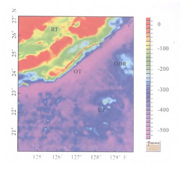
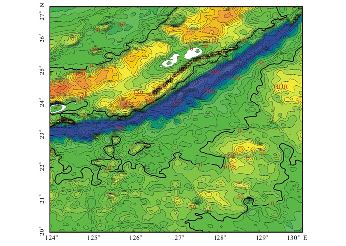
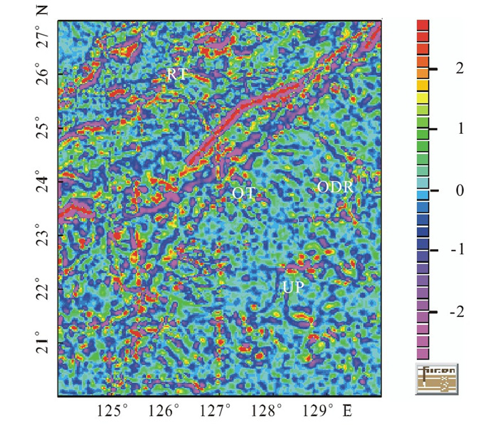
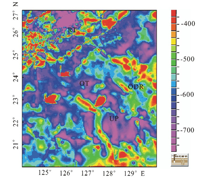
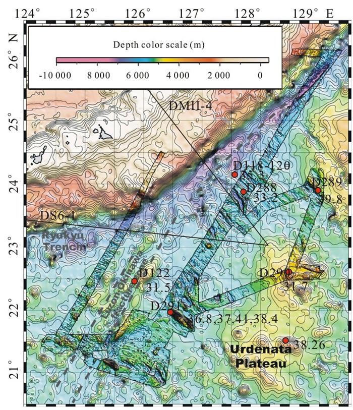
The West Philippine basin (WPB) is a currently inactive marginal basin belonging to Philippine Sea plate, which has a complex formation history and various crust structures. Based on gravity, magnetic and seismic data, the tectonics in West Philippine basin is characterized by amagma spreading stage and strike slip fractures. NNE trending Okinawa-Luzon fracture zone is a large fracture zone with apparent geomorphology and shows a right-handed movement. The results of joint gravity-magnetic-seismic inversion suggest that the Okinawa-Luzon fracture zone has intensive deformation and is a transform fault. Western existence of the NW trending fractures under Ryukyu Islands Arc is the main cause of the differences between south and north Okinawa Trough. The Urdaneta plateau is not a remained arc, but remnant of mantle plume although its lava chemistry is similar to oceanic island basalt (OIB).
The West Philippine basin is a currently inactive marginal basin belonging to Philippine Sea plate and subducts at the Ryukyu Trench (RT) to the north (Fig.1) and at the Philippine Trench (PT) to the west.It is one of the oldest basins in West Pacific margins, with a complex formation history (Deschamps and Lallemand, 2002; Deschamps et al., 1999; Hilde and Lee, 1984).On the origin of the basin, some scholars thought that it is a trapped oceanic basin (Hilde and Lee, 1984;Mrozowski et al., 1982; Uyeda and Ben-Avraham, 1972); whereas others suggested it is a back-arc spreading basin (Deschamps and Lallemand, 2002; Hall, 2002, 1997; Okino et al., 1999; Hall et al., 1995a, b).The most referred model proposed for the spreading processes within the basin is from Hilde and Lee (1984),they analyzed magnetic anomalies and seafloor structures and indicated that the basin was formed during 58–33 Ma and was divided into two phases of spreading in an NE-SW and N-S directions, respectively, from a single spreading center.
Since 1984, several geophysical surveys have been performed in the WPB, mainly over its central part.Data collected during these surveys show that the spreading history is much more complicated than that inferred in Hilde and Lee's model (Okino and Fujioka, 2003; Deschamps and Lallemand, 2002; Fujioka et al., 2000; Deschamps et al., 1999; Okino et al., 1999).Deschamps and Lallemand (2002)showed that spreading in the basin occurred from 54 Ma to 33/30Ma.The tectonics is more complicated in the western part of basin than that in eastern part, due to the presence of an active mantle plume in this region during spreading.In the northwestern WPB, the Hydrographic Department of Japan Maritime Safety Agency has recently conducted geophysical surveys including seabeam mapping, gravity and magnetic anomalies, at least three fabrics formed between two overlapping spreading centers have been identified based on these results (Yoshida et al., 2000).Deschamps and Lallemand (2002) proposed that NE-SW direction spreading, which was highly disorganized in this part of the basin, was due to the presence of an active mantle plume during spreading.The Urdenata plateau (UP) in the northern basin and the Benham plateau (BP) in the southern basin result from the interaction of such a mantle plume with the western part of the WPB spreading system (Okino and Fujioka, 2003; Deschamps and Lallemand, 2002; Okino et al., 1999).The western part of the WPB then displays rough and complicated morphology and excess magmatism.
Another important feature of the western WPB is the Okinawa-Luzon fracture zone (OLF) (Fig.1).It extends hundreds of kilometers long over its apparent part and trends perpendicular to the spreading fabric.This feature is interpreted to be a major inactive fracture zone of the WPB that was active during spreading in Eocene (Deschamps and Lallemand, 2002; Deschamps et al., 1999; Hilde and Lee, 1984).Wang et al. (1996) thought that the OLF is a right-handed fracture zone with NE trending and the main cause of the termination or displacement of the central basin ridge at its northwestern end.But they focused only on the topography and the magnetic data ofHilde and Lee (1984), and didn't discuss its fracture and development.This article mainly discusses the tectonics of the northwestern WPB and its formation, based on marine gravity, magnetic and seismic data.
Gravity, magnetic and bathymetry are mainly from KR03-04 cruise, assisting with data from National Geophysical Data Center (NGDC) and Smith and Sandwell (1997).And the multi-channel seismic data were collected by Institute of Oceanology, Chinese Academy of Sciences during 1982–1984.Samples are mainly from R/V KR03-04 cruise.
Though the gravity data are the revised free-air gravity anomaly (gf), the data are gained from different cruises and different times; the precisions are different from each other.Based on the data from KR03-04 cruise, closing error is made.The Bugers gravity anomaly (gB) could be gained from free-air gravity anomaly by the following formula
gB=gf+0.068 7H (mGal)
where H is the water depth, H < 0, unit is meter.
And then, we can make general proceeding on Bugers gravity anomaly, such as continuation and differential.Revising the closing error is also suitable for magnetic data.The seismic data were collected by Kexue I of Chinese Academy of Sciences during1990s, and the interpretation of the data refers to Wu et al. (2007).Age dating is done by Shinjo Ryuichi, using Ar-Ar dating method.
Based on the above data, a joint inversion of the gravity, magnetic and seismic data have been done following the steps according to Yan (2004) : (1) according to the seismic profile interpretation, construct initial inversion geology model; (2) using the densities of the layers, calculate the gravity anomaly; (3) compared with observed gravity anomaly, revise the model to make the calculated gravity anomaly fit with the observed gravity anomaly.
As shown in Fig.2, the Bugers gravity anomaly around Oki-Daito Ridge (ODR) is high in middle and low around.Similar results can be seen in the Urdaneta plateau (UP).But Bugers anomaly in the north UP is higher than that in south.The OLF zone is disordered, high and low appearance in turn.This phenomenon is very clear on the map of 3rd trending surface Bugers gravity anomaly (Fig.3).In order to distinguish shallow and deep structures, we make downward and upward continuations of Bugers gravity anomaly (Fig.4).On Fig.4, the anomaly of OLF zone changes largely, on the 15 km upward continuation map, there is no local anomalies.It shows that most of the structures in the OLF area are shallow, only one is deep.In ODR and UP, most of the structures are deep, only few shallow.On the 2nd vertical differential map (Fig.5), we can identify many structures, mainly shallow.
On reduction to pole magnetic anomaly map (Fig.6), there are five magnetic lineations from south to north, corresponding to 18–22 magnetic lineations in Hilde and Lee (1984).But in Fig.1, the rock age varies from 30 Ma to 40 Ma, which is not consistent with 18–22 magnetic lineations.The reason may be that these rocks experienced tectonic movement.In whole, the anomaly intension is small, between (-180–180) nT.Also, in OLF zone, anomaly is highly disordered.
Seismic profile DS6-1 (Fig.7) starts at (23°8′N, 128°3.6′E), and ends at (23°23.2′N, 124°23.2′E), with 290 km length, trending NWW, and meeting Ryukyu Islands with 30°angle.It crosses four tectonic units: Philippine Sea abyssal plain, outside rise of Ryukyu Trench (that is OLF zone), Ryukyu Trench (RT), and slope of Ryukyu Islands.The slope of outer rise (Fig.7a) is very steep.Its west side is a fault, while east is a gentle slope.Across the profile (Fig.7b), the broken crust and very undulate geomorphology indicate the existence of fracture structures in the area.In the trough floor, thin sedimentary layer with the thickness of 200–400 m is filled.Under thin sediment layer, there is base rock broken zone.The thickness is about2 000–4 000 m.The oceanic crust appears under sedimentary layers on the profile (Fig.9).
Seismic profile DMII-4 (Fig.8) starts at (26°3.8′N, 126°3.0′E), and ends at (23°9.6′N, 128°0.4′E), with NW trending, crosses vertically with RT.The outer rise is composed of a series of steep ridges, about 30 km length.Some high angle normal faults trending NW form rift valleys in the outer rise.In Philippine Sea abyssal plain, an extensional fault divides it with the outer rise.The reflector of basement is very clear with a little fluctuation.It occurs at about 4.5–4.25 s in two-way travel time and has lifting to SE.Thin sediment layers with clear-layered reflectors cover over the basement and have about 200 m thickness.Because of the existence of outer ridges, some SE trending thrust fractures are well developed in the trench and inner slope, while the extensional structures occurred in the southeast of the profile (Fig.8).
In order to find out the depth of OLF zone, we make joint inversion of DS6-1 and DMII-4 profiles, according toDai (2004) and Ding et al. (2004).The results are shown in Figs.9 and 10.The magnetic data fit very well both in the seismic profiles DS6-1 (Fig.9) and DMII-4 (Fig.10).Whereas the gravity data cannot fit very well in the whole section (Fig.10), especially in the RT area, and calculated curve cannot fit well with observed curve.The OLF zone shows the magnetic curve jumps, but does not locate at the top of the topography and the highest of the gravity anomaly.We infer that the OLF zone is broken hardly with density of 2.3–2.4 g/cm3, and deep magnetic magma complex.In Philippine Sea abyssal plain, sediment layer is very thin.Under it, we inferred that there is the broken basement rock with low density of 2.35g/cm3.The model can fit well with the interpretation of the joint inversion results (Fig.9).
In profile DMII-4, outer rise consists of basalt seamount, with density of 2.7–2.8 g/cm3.For giant resistance to this seamount subduction, the rise suppressed intensive compression.It shows minimum magnetics, no change in gravity values and low density about 2.4 g/cm3.And in Philippine Sea abyssal plain, the crust structure is the same as the profile DS6-1.
Based on magnetic lineations, Hilde and Lee (1984) proposed that the tectonic of this area is in NW direction and may be formed from the Central Basin Ridge.On the tomography map, gravity anomaly map and magnetic anomaly map, we also discovered the NW structures in west part of WPB and the structures parallel with the Central Basin Ridge.Obviously, in this part of WPB, it is the result of spreading from Central Basin Ridge (Lin and Li, 1999).And age of spreading is not defined.According to Hilde and Lee (1984), it happened at 60–45 Ma, magnetic lineations are 26–13.But our age data of samples derived from this area are between 40–30 Ma, this period is inactivity stage (Deschamps and Lallemand, 2002).As these samples are basalt and most are badly weathered, their formation in amagma spreading stage is not possible.Our data support that it was formed from Central Basin Ridge during 40–30 Ma.In Fig.1, we also find that the ages of north (Dive 290) and south of Urdaneta plateau are different.The age in the south is 36–39 Ma, while that in the north is 31 Ma which is same as the age around oceanic crust (Dive 291, 288).Lacking of the spreading magnetic lineations, we cannot define the data of amagma spreading stage.
The fracture zone appears as three faults in Fig.5 and Fig.1, and has about hundred kilometers width.In Fig.1, rock sample in the zone (Dive 122) with the31.5 Ma age also is a basalt rock not a metamorphic rock.Lacking of age of west side oceanic crust of this fracture zone, we could not identify clearly when it was formed.Wang et al. (1996) assumed it was a strike-slip fault and main cause for termination or displacement of Central Basin Ridge, and Svarichevsky and Wang (1992) believed the northwestern part of the Central Basin Ridge has been displaced along some fractured under the Ryukyu trench-arc system, presently maybe located at Miyako fracture zone (Fig.11).In inversion maps (Figs.9, 10), the OLF zone shows low density at about 2.35 g/cm3affected by broken fracture zone.This fault is not like a common strike fault, but resembles a transform fracture zone.
The Urdaneta plateau (UP) is not a remained arc, but possible remnant of mantle plume although its lava chemistry is similar to OIB.The Urdenata plateau is a seafloor plateau according to topography map in the WPB (Fig.1).Two views exist for the formation of its tectonics.The former geologists suggested that it origins from a remained arc (Hilde and Lee, 1984), whereas others thought it is an active mantle plume (Wang et al., 1996).In map of continuation of gravity and magnetic anomaly, the UP has high thickness of crust and no apparent plume deep structure.According to DSDP 294/5, rock age around the UP is about 19Ma by Ar-Ar dating (Ozima et al., 1983).That is to say, rocks around UP are younger than those in UP, and these in the northern UP are younger than the southern ones (Fig.1).However, the UP at least was younger than the spreading oceanic crust (during58–33 Ma, Deschamps and Lallemand, 2002).
Based on bathymetry, gravity, magnetic and seismic data, two groups of fracture exist in northwesternmost of WPB (Fig.11).The magnetic and topographic data provide new evidence for amagma spreading of WPB.And the deformation force may pull off the subducted Philippine Sea plate.
The OLF zone trends NNE and turns to NE off RT (126°E).It is a hardly broken zone.In northwestern corner of WPB, it appears as a right strike-slip fracture zone, with large slip distance and depth.It may be a transform fault.The presence of this fracture zone causes Ryukyu Islands and RT bend and the termination or displacement of Central Basin Ridge.
ACKNOWLEDGMENT: We thank the staff and scientists of R/V KR03-04 cruise for their hard-earned data.Dai, M. G., 2004. Inversion Research for Gravity and Synthetical Interpretation of Two Profiles in the Area of East China Sea and Its Adjacency. Progress in Geophysics, 19 (2): 331–340 (in Chinese with English Abstract). |
Deschamps, A., Lallemand, S., 2002. The West Philippine Basin: An Eocene to Early Oligocene Back Arc Basin Opened between Two Opposed Subduction Zones. Journal of Geophysical Research, 107 (B12, 24): 10. Doi: 10.1029/2001JB001706. |
Deschamps, A., Lallemand, S., Dominguez, S., 1999. The LastSpreading Episode of the West Philippine Basin Revisited. Geophys. Res. Lett. , 26 (14): 2073–2076. doi: 10.1029/1999GL900448 |
Ding, H. T., Chen, B., Gao, D. Z., et al., 2004. Integrated Geophysical Interpretation of the Typical Profile of the East China Sea Shelf Basin. Progress in Exploration Geophysics, 27 (4): 269–273 (in Chinese with English Abstract). |
Fujioka, K., Kanamatsu, T., Ohara, Y., et al., 2000. Parece Vela Rift and Central Basin Fault revisited: STEPS IV (Structure, Tectonics and Evolution of the Philippine Sea); Cruise Summary Report. InterRidge News, 9: 18–22. |
Hall, R., 1997. Cenozoic Plate Tectonic Reconstructions of SE Asia. In: Fraser, A. J., Matthews, S. J., Murphy, R. W., eds., Petroleum Geology of Southeast Asia. Geological Society Special Publications, 126: 11–23. |
Hall, R., 2002. Cenozoic Geological and Plate TectonicEvolution of SE Asia and the SW Pacific: Computer-Based Reconstructions, Model and Animations. Journal of Asian Earth Sciences, 20 (4): 353–431. doi: 10.1016/S1367-9120(01)00069-4 |
Hall, R., Ali, J. R., Andanderson, C. D., 1995a. Cenozoic Motion of the Philippine Sea Plate: Paleomagnetic Evidence from Eastern Indonesia. Tectonics, 14 (5): 1117–1132. doi: 10.1029/95TC01694 |
Hall, R., Ali, J. R., Anderson, C. D., et al., 1995b. Origin and Motion History of the Philippine Sea Plate. Tectonophysics, 251 (1–4): 229–250. |
Hilde, T. W. C., Lee, C. S., 1984. Origin and Evolution of the West Philippine Basin: A New Interpretation. Tectonophysics, 102 (1–4): 85–104. |
Lin, M. H., Li, N. S., 1999. Geomorphic Study of the Central Rift Zone in the West Philippine Sea. Marine Geology & Quaternary Geology, 19 (1): 39–44 (in Chinese with English Abstract). |
Mrozowski, C. L., Lewis, S. D., Hayes, D. E., 1982. Complexities in the Tectonic Evolution of the West Philippine Basin. Tectonophysics, 82 (1–2): 1–24. |
Okino, K., Fujioka, K., 2003. The Central Basin Spreading Center in the Philippine Sea: Structure of an Extinct Spreading Center and Implications for Marginal Basin Formation. J. Geophys. Res. , 108 (B1, 18): 10. Doi: 10.1029/2001JB001095. |
Okino, K., Ohara, Y., Kasuga, S., et al., 1999. The Philippine Sea: A New Survey Results Reveal the Structure and History of the Marginal Basins. Geophys. Res. Lett. , 26 (15): 2287–2290. doi: 10.1029/1999GL900537 |
Ozima, M., Kaneoka, I., Saito, K., et al., 1983. Summary of Geochronological Studies of Submarine Rocks from the Western Pacific Ocean. In: Hilde, T. W. C., Uyeda, S., eds., Geodynamics of the Western Pacific-Indonesian Region, Geodynamics Series, 11: 137–142. |
Smith, W., Sandwell, D., 1997. Measured and Estimated Seafloor Topography, World Data Center for Marine Geology & Geophysics. Boulder Research Publication RP-1. |
Svarichevshy, A. S., Wang, C., 1992. The Luzon-Okinawa Fracture Zone in the West Philippine Basin. Proceedings of Fourth Taiwan Symposium on Geophysics, 465–475. |
Uyeda, S., Ben-Avraham, Z., 1972. Origin and Development of the Philippine Sea. Nature, 240: 176–178. |
Wang, C. S., Svarichevskiy, A. S., Huang, C. F., et al., 1996. A Strike-Slip Fault System Trending NE in and around the Northwestern Corner of the West Philippine Basin. TAO, 17 (4): 489–504. |
Wu, S. G., Ni, X. L., Guo, J. H., 2007. Balanced Cross Section for Restoration of Tectonic Evolution in the Southwest Okinawa Trough. Journal of China University of Geosciences, 18 (1): 1–10. doi: 10.1016/S1002-0705(07)60013-2 |
Yan, H. J., 2004. Theoretical Exploration for Gravity, Magnetic Planar Statistical Modeling Inversion. Journal of Northwest University (Natural Science Edition), 34 (2): 218–222 (in Chinese with English Abstract). |
Yoshida, T., Ohara, Y., Kato, S., et al., 2000. Possible Dueling Propagators in the Northwestern West Philippine Basin. EOS Trans. AGU 81, WP212, AGU 2000 Western Pacific Geophysics Meeting, Poster Presentation. |