| Citation: | An Wang, Guocan Wang, Kexin Zhang, Shuyuan Xiang, Dewei Li, Demin Liu. Late Neogene Mountain Building of Eastern Kunlun Orogen: Constrained by DEM Analysis. Journal of Earth Science, 2009, 20(2): 391-400. doi: 10.1007/s12583-009-0032-1

|
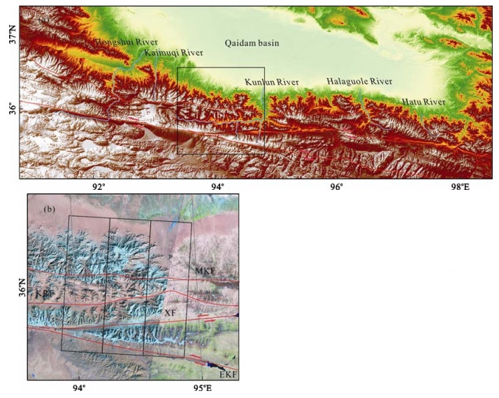
Topography, as a net result of the dynamic interaction between endogenesis and exogenesis, holds immense information on tectonic uplift, surface erosion and thus mountain building. The eastern Kunlun (昆仑) orogen, which experienced significant Late Neogene tectonic uplift and is located in an arid environment, is advantageous for morphotectonic analysis based on well-preserved tectonic landforms. The digital elevation model (DEM) analysis was carried out for the central segment of the eastern Kunlun orogen based on shuttle radar topography mission (SRTM) data. River longitudinal profile analysis indicates that major rivers across the orogen are characterized by high river gradient indexes and intensive tectonic uplift. Differential uplift was also identified in swath-topography analysis in the studied area, which can be divided into three major tectonic-geomorphic units by orogenic- strike-parallel faults. It is indicated that the most active region is located to the south of the Xidatan (西大滩) fault with significant differential uplift. Another identified fault with differential uplift is the Middle Kunlun fault; however, the timing of which is suggested to be much older than that of the Xidatan fault. These analyses are concordantly supported by both field survey and studies of thermochronology, which in turn indicates that the DEM analysis bears great potential in morphotectonic analysis.

| Ben, M. L., Haviv, I., Enzel, Y., et al., 2008. Incision of Alluvial Channels in Response to a Continuous Base Level Fall: Field Characterization, Modeling, and Validation along the Dead Sea. Geomorphology, 93(3–4): 524–536 http://www.researchgate.net/profile/Yehouda_Enzel/publication/223185055_Incision_of_alluvial_channels_in_response_to_a_continuous_base_level_fall_Field_characterization_modeling_and_validation_along_the_Dead_Sea/links/02e7e53564f0b3aa5d000000 |
| Bishop, M. P., Shroder, J. F., Bonk, R., et al., 2002. Geomorphic Change in High Mountains: A Western Himalayan Perspective. Global and Planetary Change, 32(4): 311–329 doi: 10.1016/S0921-8181(02)00073-5 |
| Brookfield, M. E., 1998. The Evolution of the Great River Systems of Southern Asia during the Cenozoic India-Asia Collision: Rivers Draining Southwards. Geomorphology, 22(3–4): 285–312 |
| Chen, Y. C., Sung, Q., Cheng, K. Y., 2003. Along-Strike Variations of Morphotectonic Features in the Western Foothills of Taiwan: Tectonic Implications Based on Stream-Gradient and Hypsometric Analysis. Geomorphology, 56(1–2): 109–137 http://www.sciencedirect.com/science/article/pii/S0169555X0300059X |
| Cheng, Q. M., Zhang, G., Lu, C., et al., 2004. GIS Spatial-Temporal Modeling of Water Systems in Greater Toronto Area, Canada. Journal of China University of Geosciences, 15(3): 275–282 |
| Cui, Z. J., Gao, Q. Z., Liu, G. N., et al., 1996. Planation Surfaces, Palaeokarst and Uplift of Xizang (Qinghai-Xizang) Plateau. Science in China (Series D), 26(4): 378–386 (in Chinese) http://www.cnki.com.cn/Article/CJFDTotal-JDXG199604005.htm |
| Davis, W. M., 1899. The Geographical Cycle. Geographical Journal, 14: 478–504 |
| Fu, B., Awata, Y., 2007. Displacement and Timing of Left-Lateral Faulting in the Kunlun Fault Zone, Northern Tibet, Inferred from Geologic and Geomorphic Features. Journal of Asian Earth Sciences, 29(2–3): 253–265 http://www.sciencedirect.com/science/article/pii/s1367912006000770 |
| Fu, B., Awata, Y., Du, J., et al., 2005. Complex Geometry and Segmentation of the Surface Rupture Associated with the 14 November 2001 Great Kunlun Earthquake, Northern Tibet, China. Tectonophysics, 407(1–2): 43–63 http://www.onacademic.com/detail/journal_1000035440169310_20cf.html |
| Hack, J. T., 1973. Stream-Profile Analysis and Stream-Gradient Index. Journal of Research of the U. S. Geological Survey, 1(4): 421–429 http://pubs.usgs.gov/journal/1973/vol1issue4/report.pdf |
| Hack, J. T., 1982. Physiographic Divisions and Differential Uplift in the Piedmont and Blue Ridge. U.S. Geological Survey Professional Paper, 1265: 49 http://pubs.usgs.gov/pp/1265/report.pdf |
| Jamieson, S. S., Sinclair, H. D., Kirstein, L. A., et al., 2004. Tectonic Forcing of Longitudinal Valleys in the Himalaya: Morphological Analysis of the Ladakh Batholith, North India. Geomorphology, 58(1–4): 49–65 http://www.sages.ac.uk/home/homes/sinclair/Jamieson.pdf |
| Li, B. Y., Pan, B. T., Gao, H. S., 2002. A Planation Surface and Ages of Volcanic Rocks in Eastern Hohxil, Qinghai-Tibetan Plateau. Quaternary Sciences, 22(5): 297–405 (in Chinese with English Abstract) http://en.cnki.com.cn/Article_en/CJFDTOTAL-DSJJ200205000.htm |
| Li, Z. L., Zhu, Q., 2003. Digital Elevation Model. Press of University of Geodesy and Geomatics, Wuhan. 2–5 (in Chinese) |
| Lin, A., Fu, B., Guo, J., et al., 2002. Co-seismic Strike-Slip and Rupture Length Produced by the 2001 Ms8.1 Central Kunlun Earthquake. Science, 296(5575): 2015–2017 doi: 10.1126/science.1070879 |
| Ma, Y. S., Shi, W., Zhang, Y. Q., 2005. Characteristics of the Activity in Maqu Segment of the East Kunlun Active Fault Belt and Its Eastward Extension. Geological Bulletin of China, 24(1): 30–35 (in Chinese with English Abstract) http://en.cnki.com.cn/Article_en/CJFDTOTAL-ZQYD200501005.htm |
| Mackin, J. H., 1948. Concept of the Graded River. Geological Society of America Bulletin, 5: 463–511 |
| Masek, J. G., Isacks, B. L., Gubbels, T. L., et al., 1994. Erosion and Tectonics at the Margins of Continental Plateaus. Journal of Geophysical Research, 99(B7): 13941–13956 doi: 10.1029/94JB00461 |
| Montgomery, D. R., Balco, G., Willett, S. D., 2001. Climate, Tectonics, and the Morphology of the Andes. Geology, 29(7): 579–582 doi: 10.1130/0091-7613(2001)029<0579:CTATMO>2.0.CO;2 |
| Ohmori, H., 1993. Changes in the Hypsometric Curve through Mountain Building Resulting from Concurrent Tectonics and Denudation. Geomorphology, 8(4): 263–277 doi: 10.1016/0169-555X(93)90023-U |
| Phillips, J., 1995. Nonlinear Dynamics and the Evolution of Relief. Geomorphology, 14(1): 57–64 doi: 10.1016/0169-555X(95)00026-2 |
| Strahler, A. N., 1952. Hypsometric (Area-Altitude Curve) Analysis of Erosional Topography. Geological Society of America Bulletin, 63(11): 1117–1142 doi: 10.1130/0016-7606(1952)63[1117:HAAOET]2.0.CO;2 |
| Ufimtsev, G. F., 1995. The Third Face of Tectonics—Tectonic Analysis of Relief. Earth Science Frontiers, 2(1–2): 9–18 http://en.cnki.com.cn/Article_en/CJFDTOTAL-DXQY501.002.htm |
| Wang, A., Wang, G. C., 2005. Review on Morphotectonic and Its Analytical Methods. Geological Science and Technology Information, 24(4): 7–12 (in Chinese with English Abstract) http://en.cnki.com.cn/Article_en/CJFDTOTAL-DZKQ200504002.htm |
| Wang, A., Wang, G. C., Xiang, S. Y., 2003. Characteristics of River Terraces in North Slope of Eastern Kunlun Mountains and Their Relationship with Plateau Uplift. Earth Science—Journal of China University of Geosciences, 28(6): 675–679 (in Chinese with English Abstract) http://www.en.cnki.com.cn/Article_en/CJFDTOTAL-DQKX200306014.htm |
| Wang, A., Wang, G. C., Xie, D. F., et al., 2006. Fission Track Geochronology of Xiaonanchuan Pluton and the Morphotectonic Evolution of Eastern Kunlun since Late Miocene. Journal of China University of Geosciences, 17(4): 302–309 doi: 10.1016/S1002-0705(07)60003-X |
| Wang, F., Lo, C. H., Li, Q., et al., 2004. Onset Timing of Significant Unroofing around Qaidam Basin, Northern Tibet, China: Constraints from 40Ar/39Ar and FT Thermochronology on Granitoids. Journal of Asian Earth Sciences, 24(1): 59–69 doi: 10.1016/j.jseaes.2003.07.004 |
| Wang, Q. L., Wang, J. H., Zhu, G. Z., et al., 2004. Vertical Deformations of the Eastern Kunlun Fault Zone and West of Kunlun Mountain Pass Ms8.1 Earthquake. Seismology and Geology, 26(2): 273–280 (in Chinese with English Abstract) http://qikan.cqvip.com/Qikan/Article/Detail?id=9914342 |
| Wu, Y. Q., Cui, Z. J., Ge, D. K., et al., 1999. When the Qinghai-Xizang Plateau Uplift to Present Elevation. Scientia Geographica Sinica, 19(6): 481–484 (in Chinese with English Abstract) http://en.cnki.com.cn/Article_en/CJFDTOTAL-DLKX199906000.htm |
| Wu, Y., Cui, Z., Liu, G., et al., 2001. Quaternary Geomorphological Evolution of the Kunlun Pass Area and Uplift of the Qinghai-Xizang (Tibet) Plateau. Geomorphology, 36(3–4): 203–216 http://www.onacademic.com/detail/journal_1000035495316510_a389.html |
| Wu, Z. H., Hu, D. G., Wu, Z. H., et al., 2006. Pressure Ridges and Their Ages of the Xidatan Strike-Slip Fault in South Kunlun Mts. Geological Review, 52(1): 15–25 (in Chinese with English Abstract) http://www.researchgate.net/publication/292423156_Pressure_Ridges_and_Their_Ages_of_the_Xidatan_Strike-Slip_Fault_in_South_Kunlun_Mts |
| Xiang, S. Y., Wang, G. C., Deng, Z. L., 2003. Deposit Response to Important Tectonic Events of Cenozoic Plateau Uplift, East Segment of Eastern Kunlun Mountains. Earth Science—Journal of China University of Geosciences, 28(6): 615–620 (in Chinese with English Abstract) http://en.cnki.com.cn/Article_en/CJFDTOTAL-DQKX200306010.htm |
| Xu, X., Chen, W., Ma, W., et al., 2002. Surface Rupture of the Kunlunshan Earthquake (Ms8.1), Northern Tibetan Plateau, China. Seismological Research Letters, 73(6): 884–892 doi: 10.1785/gssrl.73.6.884 |
| Yin, H. F., Zhang, K. X., 1997. Characteristics of the Eastern Kunlun Orogenic Belt. Earth Science—Journal of China University of Geosciences, 22(4): 339–342 (in Chinese with English Abstract) http://www.researchgate.net/publication/306203698_Characteristics_of_the_eastern_Kunlun_orogenic_belt |
Figures(6) / Tables(1)
Copyright © 2013-2020 Journal of Earth Science 鄂ICP备15021562号-2
Tel: +86-27-67885075 Fax: +86-27-67885075 E-mail: xbb@cug.edu.cn
Address: Editorial Office of Journal, China University of Geosciences, Yujiashan, Wuhan, Hubei 430074, P. R. China
Supported by:
Beijing Renhe Information Technology Co. Ltd
E-mail:
info@rhhz.net


 DownLoad: