Advanced Search

Indexed by SCI、CA、РЖ、PA、CSA、ZR、etc .

2009 Vol. 20, No. 2

Display Method:
Research
Foreword
Jingsui Yang, Haibing Li, Paul T Robinson
2009, 20(2): 205-208. doi: 10.1007/s12583-009-0020-5
Abstract:
High-Pressure Eclogite-Blueschist Metamorphic Belt and Closure of Paleo-Tethys Ocean in Central Qiangtang, Qinghai-Tibet Plateau
Cai Li, Qingguo Zhai, Yongsheng Dong, Shen Liu, Chaoming Xie, Yanwang Wu
2009, 20(2): 209-218. doi: 10.1007/s12583-009-0021-4
Abstract:

The high-pressure metamorphic belt (HPMB) of eclogite-blueschist in Central Qiangtang (羌塘) lies in the Longmu Co (龙木错)-Shuanghu (双湖) suture zone. To the west, the HPMB extends 500 km from Hongjishan (红脊山) to Caiduochaka (才多茶卡), east of Shuanghu; to the east it extends to Baqing (巴青) and Jitang (吉塘) in Qamdo (昌都), and then bends southward to Yunnan (云南) Province. Including the Lancangjiang (澜沧江) blueschist belt, the entire HPMB is about 2 000 km long. In Central Qiangtang, the belt is mainly composed of blueschist and eclogite, whereas in West Yunnan it contains only blueschist. The Baqing-Jitang segment is dominated by garnet phengite schist. 40Ar-39Ar dating of glaucophane and phengite from the blueschists yielded plateau ages ranging from 223 to 215 Ma, whereas SHRIMP U-Pb dating of zircon from the eclogites gives metamorphic ages of 243–217 Ma. The calculated metamorphic conditions for the blueschists are 410–460 ℃ and 0.67–0.75 GPa, and for the eclogites, < 500 ℃ and 1.56–2.35 GPa. The metamorphic ages suggest that the Longmu Co-Shuanghu suture closed in the Late Triassic. The region south of the Longmu Co-Shuanghu-Lancang suture consists of the pan-African basement overlain by Gondwana sedimentary and meta-sedimentary rocks, whereas the region north of the suture is dominated by the Jinning (晋宁) basement and Yangtze sedimentary and metasedimentary rocks. The Qiangtang HPMB marks the closure of the paleo-Tethys Ocean.

P-T Paths Derived from Garnet Growth Zoning in Danba Domal Metamorphic Terrain, Sichuan Province, West China
Suhua Cheng, Xingyun Lai, Zhendong You
2009, 20(2): 219-240. doi: 10.1007/s12583-009-0022-3
Abstract:

Danba (丹巴) domal metamorphic terrain belongs to Songpan (松潘)-Ganze (甘孜) orogenic belt, where typical Barrovian and Buchan metamorphic zones are preserved. The former included chlorite, biotite, garnet, staurolite, kyanite and sillimanite zones, while the latter only developed silimanite+muscovite and sillimanite+K-feldspar zones. Integrated study has been carried on metamorphic reactions of garnet production and consumption, P-T paths and P-T-X-M phase relation and thermal tectonic model for Danba metamorphic zones. Petrological textures in thin sections show that garnet production and consumption in kyanite-sillimanite zone is mainly attributed to Chl+Ms+Pl+Q= Grt+Bt+H 2O and kyanite=sillimanite respectively. Based on mineral compositions, the geothermobarometry gives an average P, T condition of (4.9±0.3)×10 8 Pa, 543±30 ℃ for the first growth stage of the garnet and (5.8±0.3)×10 8 Pa, 534±29 ℃ for the second stage of garnet growth respectively. Anti-counter clockwise P- T paths were drawn using Gibbs method by NCMnKFMASH system for sample G98686 in the kyanite zone. The P- T- X-M modeling for the first mineral assemblages shows that the prediction is similar to the measured values in gossular, almandine and spessartine but mole fraction of pyrope and Fe/(Fe+Mg) deviated far from the contours; while that for the second mineral assemblages exhibits that the prediction is consistent with the measured value of pyrope, grossular content and Fe/(Fe+Mg) of garnet. A thermal tectonic model that there are at least three structure levels across the thrust-decollement zones is presented according to the P- T paths, metamorphic grades and deformation styles for the staurolite-kyanite zone of the Barrovian type metamorphism, which will provide some constraints for the evolution of the nappe complex.

Mantle Input to the Crust in Southern Gangdese, Tibet, during the Cenozoic: Zircon Hf Isotopic Evidence
Xuanxue Mo, Guochen Dong, Zhidan Zhao, Dicheng Zhu, Su Zhou, Yaoling Niu
2009, 20(2): 241-249. doi: 10.1007/s12583-009-0023-2
Abstract:

The Quxu (曲水) complex is a typical intrusive among the Gangdese batholiths. Two sets of samples collected from the Mianjiang (棉将) and Niedang (聂当) villages in Quxu County, including gabbro, mafic micro-enclaves (MME), and granodiorites in each set, were well dated in a previous SHRIMP zircon U-Pb analysis (47–51 Ma). In this article, the same zircons of the 6 samples were applied for LA ICP-MS Hf isotopic analysis. The total of 6 samples yields 176Hf/ 177Hf ratio ranging from 0.282 921 to 0.283 159, corresponding to ɛHf(t) values of 6.3–14.7. Their Hf depleted-mantle modal ages (TDM) are in the range of 137–555 Ma, and the zircon Hf isotope crustal model ages (TDM C) range from 178 to 718 Ma. The mantle-like high and positive ɛHf(t) values in these samples suggest a mantle-dominated input of the juvenile source regions from which the batholith originated. The large variations in εHf(t) values, up to 5-ɛ unit among zircons within a single rock and up to 15-ɛ unit among zircons from the 6 samples, further suggest the presence of a magma mixing event during the time of magma generation. We suggest that the crustal end-member involved in the magma mixing is likely from the ancient basement within the Lhasa terrane itself. The zircon Hf isotopic compositions further suggest that magma mixing and magma underplating at about 50 Ma may have played an important role in creating the crust of the southern Tibetan plateau.

Post-Orogenic Granites in Pingwu Region, Northwest Sichuan: Evidence for North China Block and Yangtze Block Collision during Triassic
Xianzhi Pei, Zuochen Li, Saping Ding, Jianyun Feng, Ruibao Li, Yu Sun, Yafeng Zhang, Zhanqing Liu
2009, 20(2): 250-273. doi: 10.1007/s12583-009-0024-1
Abstract:

The Nanyili (南一里), Laohegou (老河沟), and Shaiziyan (筛子岩) granitic intrusions are located in the southern margin of the Bikou (碧口) block in Pingwu (平武) area, Northwest Sichuan (四川). The petrography and geochemical characteristics of the granitic intrusions as well as their source and tectonic settings are reported and discussed in this article. The Laohegou and Shaiziyan granites are with high SiO2 (69.89 wt.%–73.05 wt.%) and Al2O3 contents, and A/CNK=1.04–1.12. They are typical strongly peraluminous granites, with supersaturation in Al and Si. The abundance of ΣREE varies in the range of (33.13−89.12)×10−6. The rocks show an LREE enrichment pattern and obvious Eu negative anomaly. The trace element geochemistry is characterized evidently by a negative anomaly of Ta, Nb, Ti, etc. and a positive anomaly of Rb, Ba, Sr, etc.. Zircons of the Nanyili granite have higher Th/U ratios, and their CL images have internal oscillatory zoning, suggesting that the zircons of the samples are igneous in origin. The LA ICP-MS zircon U-Pb isotopic concordia diagram yields an age of 223.1±2.6 Ma (MSWD=1.4), which indicates that the granodiorite intrusions formed in the early Late Triassic. The Nanyili, Laohegou, and Shaiziyan granites have the characteristics of post-collisional granites and are regarded as post-orogenic granites. Thus, the granite intrusions are interpreted as syn-collisional granites that resulted from the crustal thickening caused by the collisions between the North China plate and the Yangtze plate during the Indosinian. The granitic intrusions formed in a transitional environment from syn- (compressional environment) to post-collision (extensional environment).

SiO2 Solubility in Rutile at High Temperature and High Pressure
Yufeng Ren, Yingwei Fei, Jingsui Yang, Wenji Bai
2009, 20(2): 274-283. doi: 10.1007/s12583-009-0025-0
Abstract:

Silicon-bearing rutile has been found in chromitite from the Luobusa (罗布莎) ophiolite, Tibet. However, the extent of SiO2 solubility in rutile and the nature of its origin are still unclear. At high pressure, SiO2 takes a rutile structure with Si in 6-fold coordination. Thus, high pressures may enhance its solubility in rutile because of possible isovalent exchange in the octahedral site. In this study, we report new experimental results on SiO2 solubility in rutile up to 23 GPa and 2 000 ℃. Starting materials were mixtures of powdered pure rutile and pure quartz, with compositions of (Ti0.5Si0.5)O2, (Ti0.93Si0.07)O2, and (Ti0.75Si0.25)O2. The mixtures were loaded into either platinum capsules (for a 10/5 assembly) or rhenium capsules (for an 8/3 assembly). The experiments were carried out using multi-anvil high-pressure apparatus with a rhenium resistance heater. Sample temperatures were measured with a W5%Re-W26%Re thermocouple and were controlled within ±1 ℃ of the set temperature. TiO2-rich and SiO2-rich phases were produced in all the quenched samples. Microprobe analyses of the phases show that the solubility of SiO2 in rutile increases with increasing pressure, from 1.5 wt.% SiO2 at 10 GPa to 3.8 wt.% SiO2 at 23 GPa at a temperature of 1 800 ℃. The solubility also increases with increasing temperature from 0.5 wt.% SiO2 at 1 500° to 4.5 wt.% SiO2 at 2 000° at a pressure of 18 GPa. On the other hand, the solubility of TiO2 in coesite or stishovite is very limited, with an average of 0.6 wt.% TiO2 over the experimental P-T ranges. Temperature has a much larger effect on the solubility of SiO2 in rutile than pressure. At high pressure, the melting point of SiO2 is definitely higher than that of TiO2 and the eutectic point moves towards SiO2 in the TiO2-SiO2 system. Lower oxygen fugacity decreases the solubility of SiO2 in rutile, whereas water has little effect on the solubility. Our experimental data are extremely useful for determining the depth of origin of the SiO2-bearing rutile found in nature.

Unusual Mantle Mineral Group from Chromitite Orebody Cr-11 in Luobusa Ophiolite of Yarlung-Zangbo Suture Zone, Tibet
Xiangzhen Xu, Jingsui Yang, Songyong Chen, Qingsong Fang, Wenji Bai, Dengzhu Ba
2009, 20(2): 284-302. doi: 10.1007/s12583-009-0026-z
Abstract:

A wide variety of unusual mantle has been reported from podiform chromitite orebodies Cr-31 and Cr-74 in the Luobusa (罗布莎) ophiolite, Tibet. A detailed investigation of chromitite orebody Cr-11, located in the Kangjinla (康金拉) district at the eastern end of the ophiolite, has revealed many of the same minerals, including diamond, moissanite, and some native elements, alloys, oxides, sulphides, silicates, carbonates, and tungstates. This orebody is particularly rich in diamonds, with over 1 000 grains recovered from about 1 100 kg sample of chromitite. More detailed studies and experiments are needed to understand the origin and significance of these unusual minerals because they have not been found in situ. It is a great breakthrough in mineralogical research that we have picked up more than 40 kinds of minerals from the Kangjinla chromite deposit in Luobusa. It is notable that a large amount of diamonds were firstly discovered from the Kangjinla chromite deposit as well as many other unusual minerals, such as moissanites, rutiles, native irons, and metal alloys. Especially, that diamond was found again in different chromitites in the same ophiolite belt provided new key evidence for discussing the origin of the diamond and the hosted chromitite and ophiolite. The mantle mineral group in Tibet has great significance in mineralogy and geodynamics.

Dur'ngoi Ophiolite in East Kunlun, Northeast Tibetan Plateau: Evidence for Paleo-Tethyan Suture in Northwest China
Jingsui Yang, Rendeng Shi, Cailai Wu, Xibin Wang, Paul T Robinson
2009, 20(2): 303-331. doi: 10.1007/s12583-009-0027-y
Abstract:

The A'nyemaqen (阿尼玛卿) ophiolite belt along the southern margin of the East Kunlun (昆仑) Mountains marks the suture formed by the closure of paleo-Tethys. The Dur'ngoi ophiolite in the eastern part of this belt consists of meta-peridotite, mafic-ultramafic cumulates, sheeted dikes and basaltic lavas. The meta-peridotites consist of dunite, harzburgite, lherzolite, feldspar-bearing lherzolite and garnet-bearing lherzolite and contain residual spinel with Cr# [100×Cr/(Cr+Al)] ranging from 30 to 57 and Mg# [100×Mg/(Mg+Fe2+)] ranging from 50 to 75, indicating an Al- and Mg-rich series. The meta-peridotites have a relatively narrow range of composition with Mg# of 89.2–92.6, Al2O3 contents of (1–4) wt.% and slightly depleted chondrite normalized REE patterns, indicating that they represent relict mantle material that has undergone intermediate to low degrees of partial melting. Garnets in the lherzolite are andradite, enriched in Ca and Fe and depleted in Mg and Al (And=95–97, Pyr=0.3–5, Gro=0–3), indicating a metamorphic origin. The cumulate rocks mainly consist of dunite, wehrlite, pyroxenite and gabbro. A well-layered gabbro-pyroxenite complex is defined by modal variations in plagioclase and pyroxene. Blocks of garnet-pyroxenite or rodingite are locally present in the meta-peridotites. Garnets in the cumulate rocks are grossular (Gro=69–90, And=9–19, Br=1–12), also metamorphic origin. The diabase dikes are moderately depleted in LREE [(La/Sm)N=0.5-0.8] and HREE resulting in slightly convex chondrite-normalized patterns with slightly positive Eu anomalies (δEu=1.1–1.3). The basaltic lavas have REE patterns similar to those of MORB with (La/Sm)N ratios of 0.5–1 and small negative Eu anomalies. They appear to have been derived from a depleted mantle source and to have undergone little or no differentiation during crystallization. SHRIMP U-Pb dating of zircons from the basalts yields 206Pb/238U ages of 276–319 Ma (average 308.0±4.9 Ma). The Dur'ngoi ophiolite is interpreted as a dismembered fragment of paleo-oceanic crust emplaced during closure of the paleo-Tethyan Ocean basin. Three other suites of oceanic lavas are recognized in the area: island arc volcanic (IAV) rocks, possible back arc basin (BAB) basalts and possible post-collisional volcanic (PCV) and plutonic rocks. The distribution of these rocks suggests north-directed subduction. Opening of the A'nyemaqen oceanic basin started at least as early as Late Carboniferous (308 Ma) and the basin probably closed during the Early Triassic. The IAV formed in Late Permian (260 Ma), the BAB in Early-Middle Triassic, and the PCV in Late Triassic. Several large scale, ductile, sinistral strike-slip fault zones, extending hundreds to thousands kilometers, formed along or north of the suture during the Early-Late Triassic, e.g., they are the south margin fault zone of East Kunlun (200–220 Ma), the Altyn Tagh fault (220–230 Ma), and the North Qaidam fault zone (240–250 Ma). These strike-slip faults were probably generated by oblique subduction and closure of the paleo-Tethyan Ocean basin, possibly during exhumation of the subducted plate or uplift of the overriding plate, coincident with post-collisional magmatism.

Ultramafic Blocks in Sumdo Region, Lhasa Block, Eastern Tibet Plateau: An Ophiolite Unit
Songyong Chen, Jingsui Yang, Yuan Li, Xiangzhen Xu
2009, 20(2): 332-347. doi: 10.1007/s12583-009-0028-x
Abstract:

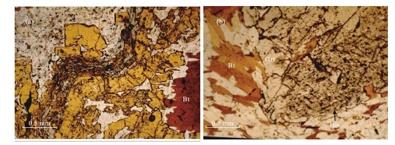
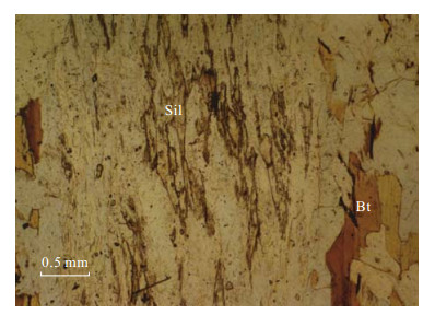
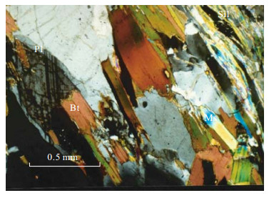
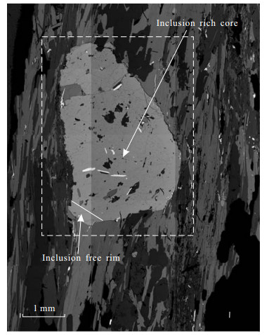
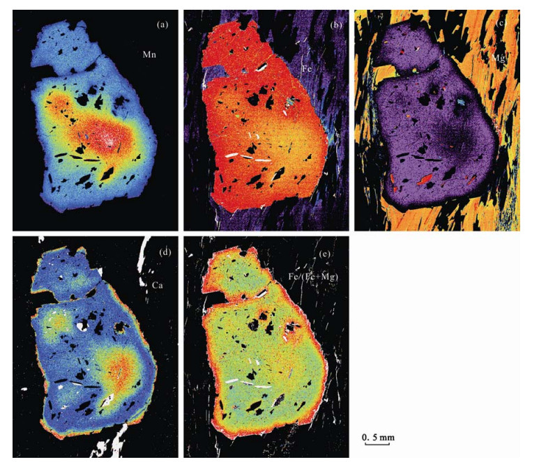
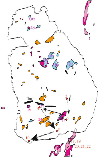
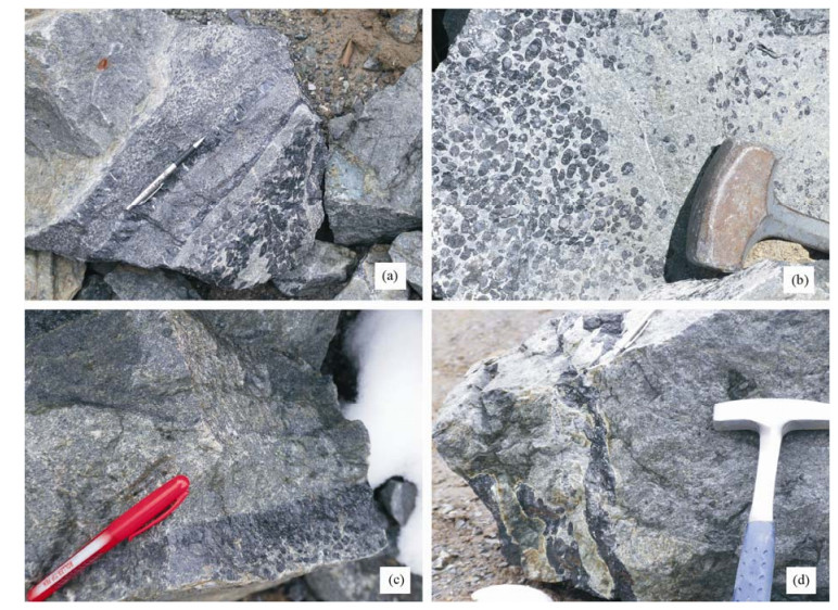
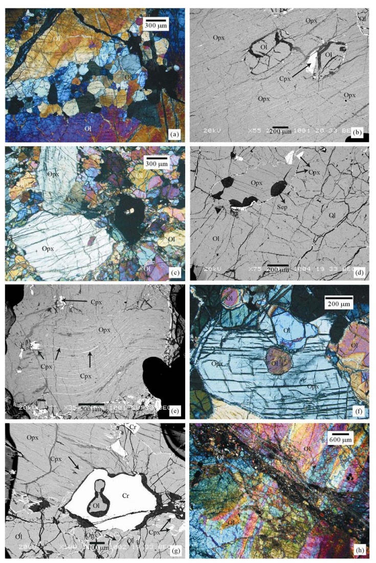
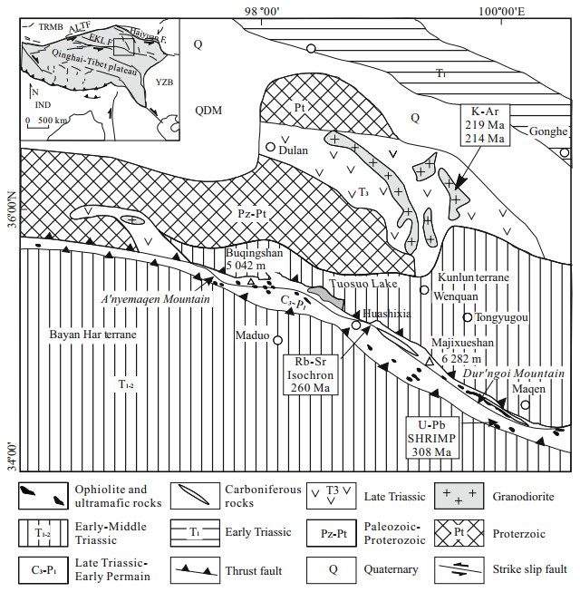
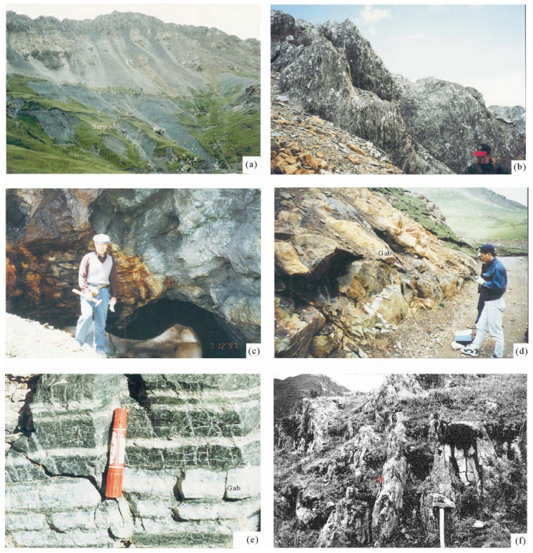
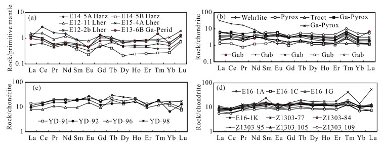
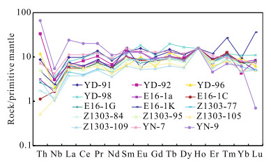
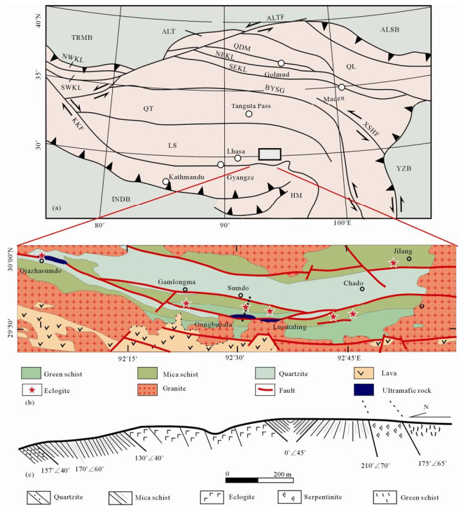
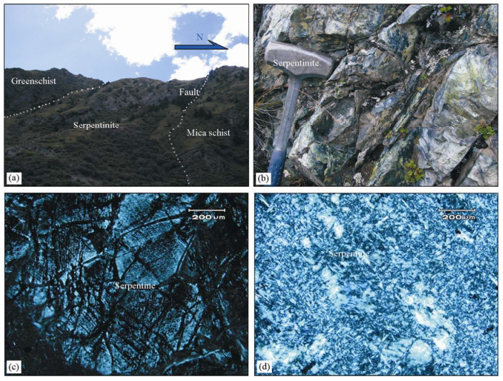
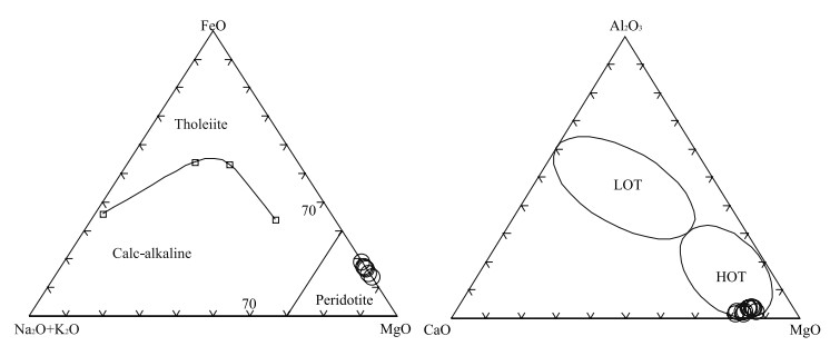
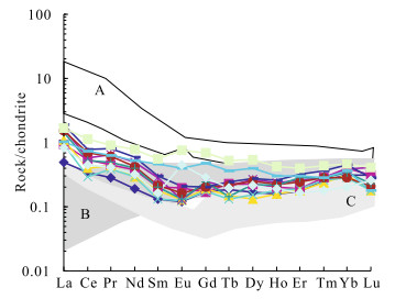
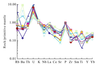
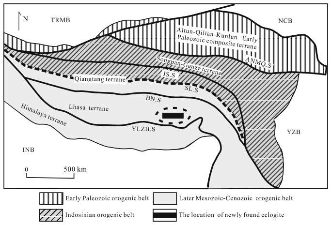
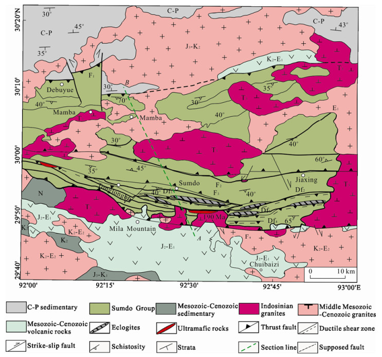
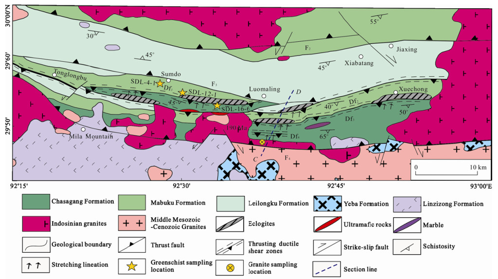
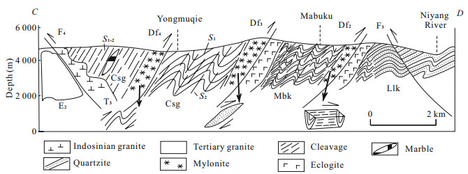
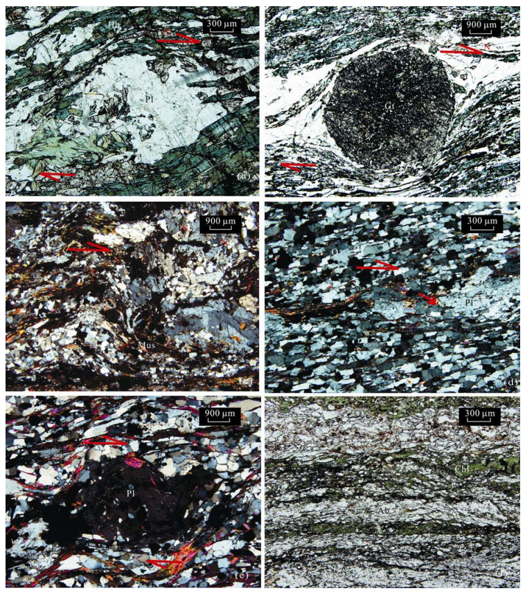
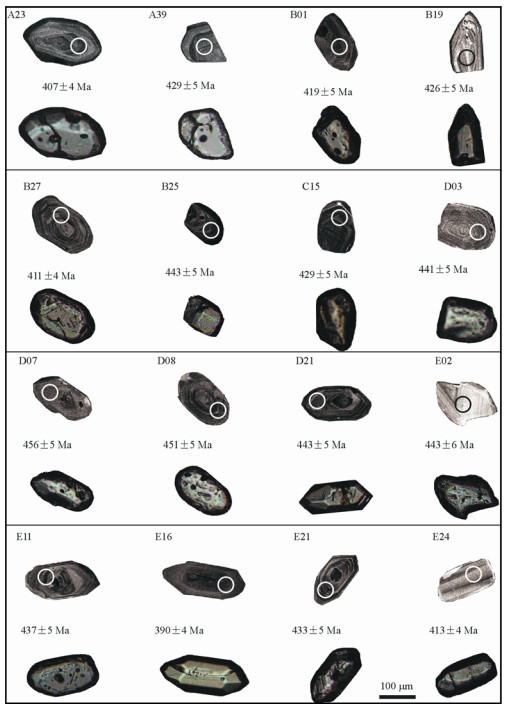
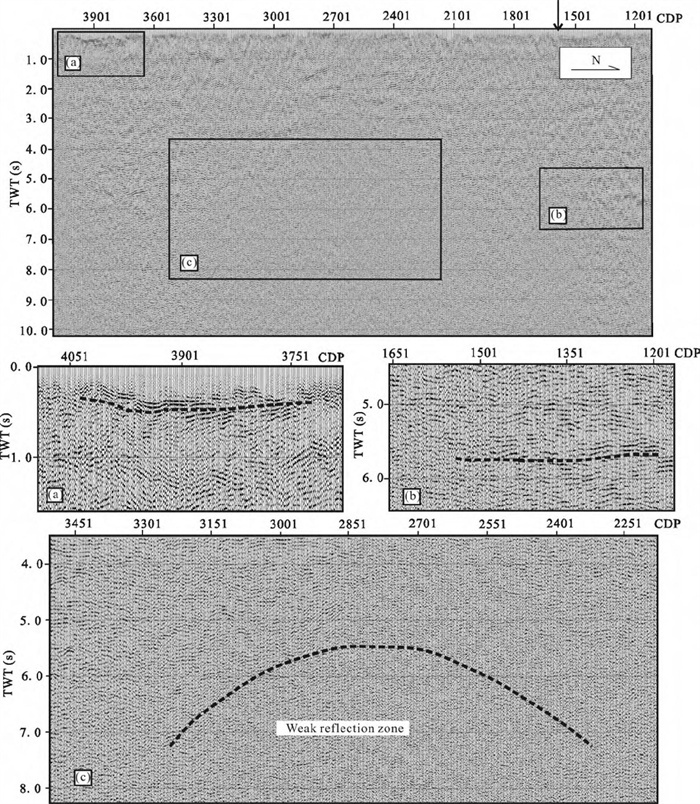
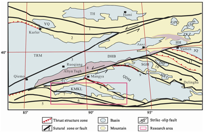
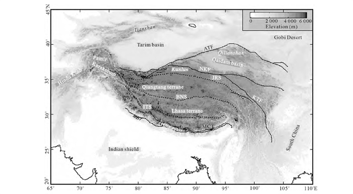
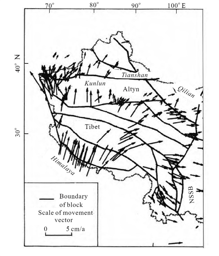
Recently, an over 100 km long MORB-type eclogite belt of Permian was discovered in the Sumdo (松多) region of the Lhasa block, Tibet. A critical question thus is: what is the tectonic setting of the eclogite belt and is it related to an unrecognized suture in the region? Further investigations show that there are some mafic and ultramafic rocks spacially associated with the eclogite belt in the region. Three ultramafic massifs were recognized in the Sumdo region, and called the Luomaling (罗马岭), Gongbupala (贡布爬拉) and Qiazhasumdo (卡扎松多) massifs. All the massifs are fault-contacted with greenschist (Chasagang (岔萨岗) Formation) or muscovite-quartz schist (Mabuku (马布库) Formation), and individuals are about 100 m×50 m in size extending in EW as the regional structure. All the ultramafic rocks have been entirely serpentinized, and the Gongbupala massif has been selected for study in geochemistry. Eleven chemical analyses of the rocks from the Gongbupala massif show a narrow range in contents: SiO2 (35.97–40.63) wt.%, MgO (37.02–38.60) wt.%, TiO2 (0.01–0.08) wt.%, Al2O3 (0.80–1.64) wt.%, (Na2O+K2O) less than 0.1 wt.%, with high volatile contents (H2O+CO2) (11.24–14.91) wt.%. After recalculation without H2O+CO2, the mean values are SiO2 45.24 wt.%, MgO 43.54 wt.%, FeOT (7.45–9.97) wt.% (8.55 wt.% in average), (MgO+FeOT) 52.09 wt.%, Mg# (100×Mg/(Mg+Fe*), where Fe* represents total Fe)=89.42–90.08, (m+f)/Si ((atomicity Mg+atomicity Fe) /atomicity Si)=1.53–1.75 (1.59 in average), respectively. The mean M/F (atomicity Mg/atomicity Fe) ratio of the rocks is 9.05, which is classified as magnesium enriched-type of ultramafic rocks. The compositional features, depleted in K, Na, Ca, Al and Ti and enriched in Mg#, indicate the characteristics of peridotite originated from a depleted mantle. The rocks have low ΣREE with (1.60–2.68)×10−6 similar to those of the primitive mantle. The chondrite-normalized REE patterns of all samples show slightly enrichment in LREE, with (Ce/Yb)N 1.03–2.46, but a little depleted in HREE. Most samples show a slight negative anomaly in Eu, a feature in REE from a relic mantle and common features in highly serpentinized ultramafic rocks in the Yarlung-Zangbo (雅鲁藏布) ophiolite and the Bangong (班公)-Nujiang (怒江) ophiolite in Tibet. The primitive mantle-normalized spiderdiagram of trace elements for Gongbupala ultramafic rocks yields uniform distributed pattern. They are relatively enriched in Rb, Ba, La, P element (LHSE) and de pleted in Sm, Ti, Y, Yb element (HFSE), a feature of metasomatic mantle peridotite. The geochemical features of the rocks suggest that the protolith of Gongbupala serpentinite in Sumdo region is harzburgite, a typical depleted mantle rock, and may represent a dismembered ophiolite unit in the region.

Records of Indosinian Orogenesis in Lhasa Terrane, Tibet
Huaqi Li, Zhiqin Xu, Jingsui Yang, Zhihui Cai, Songyong Chen, Zemin Tang
2009, 20(2): 348-363. doi: 10.1007/s12583-009-0029-9
Abstract:

Based on the deformation characteristics of the ductile shear zones in Sumdo (松多) Group, the quartz fabric by EBSD (electron backscatter diffraction), the data of muscovite 40Ar-39Ar geochronology (220–230 Ma) from ductile shear zones and the zircon SHRIMP U-Pb chronology (190 Ma) of granites in Sumdo region, Lhasa (拉萨) terrane is thought to have experienced an important Indosinian orogenic event at 220–230 Ma, which caused the closure of the paleo-Tethys Ocean along the tectonic zone of eclogite and the collision between northern part and southern part of the Lhasa terrane. The zircon SHRIMP U-Pb chronology of 190 Ma for biotite adamellite, with the distributing characteristics of the granite massif intruding in Sumdo Group, indicates that the biotite adamellite should be the late orogenic or post-orogenic granite resulting from the Indosinian orogenesis. The discovery of Indosinian orogenic belt in Lhasa terrane expansed the southern boundary of Indosinian orogenic belt in Qinghai (青海)-Tibet plateau to Lhasa terrane from Qiangtang (羌塘) terrane, which changed the understanding about the distribution of Indosinian orogenic belt in Qinghai-Tibet plateau and extended the "T" type Indosinian orogenic belt in China. The study is very important for the formation and distribution of paleo-Tethys Ocean in Tibet. The ancient terrane framework and evolution of Qinghai-Tibet plateau need further research.

Middle Permian Seamount from Xiahe Area, Gansu Province, Northwest China: Zircon U-Pb Age, Biostratigraphy and Tectonic Implications
Xiaohu Kou, Kexin Zhang, Yunhai Zhu, Zhongqiang Chen, Qixiang Lin, Fenning Chen, Jinyuan Huang
2009, 20(2): 364-364. doi: 10.1007/s12583-009-0030-3
Abstract:

The well-preserved seamount buildups are documented from the northwestern Qinling (秦岭) orogenic belts, Northwest China. The study sections are located in the Ganjia (甘加) area of the Xiahe (夏河) County, Gansu (甘肃) Province. The dark basalt and overlying massive reef carbonate characterize the Xiahe seamount buildup. Basalts are dominated by the olivine type of rocks and bear distinct porphyritic textures, and fumarole and amygdaloidal structures. The basalts are dominated by SiO2 (up to 48.49 wt.%–52.29 wt.%) followed by (Na2O+K2O) (3.80 wt.%–4.96 wt.%) and TiO2 (2.04 wt.%–2.52 wt.%). They are featured by considerably high content of Ti. The tholeiite-series rocks dominate the basalts, while calc-alkali-series rocks are also present. The REE of the basalts shows the LREE-enrichment type with distinct positive Eu abnormal. The trace elements of the basalts are characterized by the lack of P and high content of Ti. These geochemical signals suggest that the Xiahe basalts were formed in an ocean-island setting. The LA ICP-MS zircon U-Pb age of the basalts is 267.6±5 Ma, which is reinforced by the presnce of the fusulinid Neoschwagerina Zone of the Wordian (Middle Permian) in the limestone interbeds of the basalts. Integration of petrological and geochemical studies of seamount basalts and lateral correlation of seamount buildups reveals that the Qinling-Qilian-Kunlun orogenic belts were probably the archipelagic oceans during the Permian.

Late Oligocene–Early Miocene Thrusting in Southern East Kunlun Mountains, Northern Tibetan Plateau
Zhenhan Wu, Peisheng Ye, Barosh J. Patrick, Daogong Hu, Wenjin Zhao, Zhonghai Wu
2009, 20(2): 381-390. doi: 10.1007/s12583-009-0031-2
Abstract:

Southward thrusting occurred in Late Oligocene-Early Miocene in southern East Kunlun (昆仑) Mountains formed the South Kunlun thrust (SKT). Permian strata and Triassic rocks were thrusted over the Paleocene-Eocene red-beds of Fenghuoshan (风火山) Group and Oligocene brownish red conglomerate and sandstone of Yaxicuo (雅西错) Group along SKT faults, formed tectonic slices, low-angle thrust faults, multi-scaled outliers, and nappe structures in south of Middle Kunlun fault (MKF). In addition, SKT displacement or shortening is estimated to be ~(30–35) km across Dongdatan (东大滩) valley and East Wenquan (温泉) basin. 39Ar-40Ar dating of chlorite of ductile shear zone along front thrust fault indicates that SKT thrusting occurred at 26.5±2.7 Ma, and fission track dating of apatite from mylonitic granite in SKT gives the age 26±2 Ma, corresponding to initial time of rapid uplift of East Kunlun Mountains. Thrust faults and folds of SKT were covered unconformably by Late Miocene lacustrine strata, and major thrusting of SKT ended before 13.5–14.5 Ma according to regional chronological data in northern Tibetan plateau.

Late Neogene Mountain Building of Eastern Kunlun Orogen: Constrained by DEM Analysis
An Wang, Guocan Wang, Kexin Zhang, Shuyuan Xiang, Dewei Li, Demin Liu
2009, 20(2): 391-400. doi: 10.1007/s12583-009-0032-1
Abstract:

Topography, as a net result of the dynamic interaction between endogenesis and exogenesis, holds immense information on tectonic uplift, surface erosion and thus mountain building. The eastern Kunlun (昆仑) orogen, which experienced significant Late Neogene tectonic uplift and is located in an arid environment, is advantageous for morphotectonic analysis based on well-preserved tectonic landforms. The digital elevation model (DEM) analysis was carried out for the central segment of the eastern Kunlun orogen based on shuttle radar topography mission (SRTM) data. River longitudinal profile analysis indicates that major rivers across the orogen are characterized by high river gradient indexes and intensive tectonic uplift. Differential uplift was also identified in swath-topography analysis in the studied area, which can be divided into three major tectonic-geomorphic units by orogenic- strike-parallel faults. It is indicated that the most active region is located to the south of the Xidatan (西大滩) fault with significant differential uplift. Another identified fault with differential uplift is the Middle Kunlun fault; however, the timing of which is suggested to be much older than that of the Xidatan fault. These analyses are concordantly supported by both field survey and studies of thermochronology, which in turn indicates that the DEM analysis bears great potential in morphotectonic analysis.

Uplift of Northwest Margin of Tibetan Plateau: Indicated by Zircon LA ICP-MS U-Pb Dating of Conglomerate from Mazartagh, Tarim Basin
Jialiang Si, Haibing Li, Junling Pei, Jiawei Pan
2009, 20(2): 401-416. doi: 10.1007/s12583-009-0033-0
Abstract:

Radiometric age dating of detrital zircons is highly advantageous for analysis of the depositional environment and to identify source areas. Aiming at the uplift and denudation of the surrounding ranges, LA ICP-MS U-Pb analysis has been performed on zircon grains from a conglomerate collected at the Lower Pliocene of Mazartagh, which is in the center of the Tarim basin, Xinjiang (新疆), China. A wide range of ages mainly falling into three groups was yielded: 200–500, 800–1 100, and 1 800–2 000 Ma. Zircon features principally indicate magmatic origin. According to the comparison between the analyzed zircons with those from surrounding orogenic belts, the younger grains are mainly related to the west while the older ones are to the regions more eastward. The variations might imply the W-E propagation tectonic activation and uplift of the surrounding orogenic belts. The west segment uplifted and was denuded firstly, driven by the approximate W-E height difference, upon the denudation, transportation and deposition, acting as the source of young zircons analyzed. With the eastward spreading of tectonic movement, the segment more to the east rose, the meridional relief increased rapidly and began to control the flow direction, then more zircons joined in the Pliocene in Mazartagh. It is difficult to definitely explain the source of grains with similar values to that from the Altyn Mountain region, more detailed data and chronological ages with higher precision will be helpful for making more credible conclusion.

Digital Simulation on Convergence Tendency between Southwest Tienshan and Pamirs-West Kunlun Systems and Its Significance
Zhuli Qiu, Haibing Li, Junling Pei
2009, 20(2): 417-429. doi: 10.1007/s12583-009-0034-z
Abstract:

The collision between India plate and Eurasia continent 55 Ma ago caused the convergence between Southwest Tienshan and Pamirs tectonic systems, and conclusions by other researchers also suggest that the convergence will continue. Studies on the collision between these systems are helpful to the knowledge of the history and the tendency of the in-land tectonics since Cenozoic and are important in science and the real world as for environment changes, resources and energy reform, and forecast of earthquakes. For this reason, by means of digital modeling, on the basis of crustal shortening rate, crustal motion rate and data of physical properties of rocks, with the help of the FE (finite element) theory-based marc software, the United States, we address on the tendency of the convergence in this area in almost 10 Ma and draw a conclusion that the converged borders move northward and stretch southeast. The Southwest Tienshan will move more slowly and suffer less deformation than the Pamirs-West Kunlun (昆仑) system. The Pamirs-West Kunlun system will rotate counterclockwise while moving northward and extending westward.

Evidence for Tibetan Plateau Uplift in Qaidam Basin before Eocene-Oligocene Boundary and Its Climatic Implications
Junling Pei, Zhiming Sun, Xisheng Wang, Yue Zhao, Xiaohong Ge, Xinzhuan Guo, Haibing Li, Jialiang Si
2009, 20(2): 430-437. doi: 10.1007/s12583-009-0035-y
Abstract:

Geometry analysis of the Hongsanhan (红三旱) Section in the northwestern Qaidam basin illustrates the typical growth strata in the Xiaganchaigou (下干柴沟) Formation. The age and sedi-mentation rates of the Xiaganchaigou and the Shangganchaigou (上干柴沟) formations were determined by the high-resolution magnetostratigraphy. This result shows that the growth strata began to form at ca. 38.0 Ma and increased sedimentation rates occurred at ca. 37.0 Ma. The uplift of the Tibetan plateau before the Eocene-Oligocene boundary is confirmed, which enables us to better understand the relationship between climatic changes and the tectonic uplift. This uplift event could have resulted in the regional drying by blocking the moisture and contributed to the Eocene-Oligocene boundary global cooling event due to the declining atmospheric CO2 concentrations by increased weathering of the mountains.

Test of Deep Feismic Reflection Profiling across Central Uplift of Qiangtang Terrane in Tibetan Plateau
Zhanwu Lu, Rui Gao, Qiusheng Li, Rizheng He, Chaoyang Kuang, Hesheng Hou, Xiaosong Xiong, Ye Guan, Haiyan Wang, S. L. Klemperer
2009, 20(2): 438-447. doi: 10.1007/s12583-009-0036-x
Abstract:

A test of deep seismic reflection profiling across the central uplift or metamorphic belt of the Qiangtang (羌塘) terrane, Tibetan plateau, provides a first image of the crustal structure. Complex reflection patterns in the upper crust are interpreted as a series of folds and thrusts, and bivergent reflections in the lower crust may represent a convergence between the Indian and the Eurasian plates.

Moho Depth of Qinghai-Tibet Plateau Revealed by Seismic Probing
Xiaosong Xiong, Rui Gao, Qiusheng Li, Zhanwu Lu
2009, 20(2): 448-463. doi: 10.1007/s12583-009-0037-9
Abstract:

The Qinghai (青海)-Tibet plateau is the newest and biggest orogenic belt in the world and a natural laboratory for researching continental geodynamics, such as continent-continent collision, convergence, subduction, and plateau uplift. From the 1950s to the present, there have been many active-source (deep seismic sounding and deep seismic reflection profiling) and passive-source seismic probing (broadband seismic observations) implemented to reveal the crust-mantle structure. In this article, the authors mainly summarize the three seismic probings to discuss the Moho depth of the Qinghai-Tibet plateau based on the previous summaries. The result shows that the Moho of the Qinghai-Tibet plateau is very complex and its depth is very different; the whole outline of it is that the Moho depth is deeper beneath the south than the north and deeper in the west than in the east. In the Qiangtang (羌塘) terrane, the hinterland of the Qinghai-Tibet plateau, the Moho is shallower than both the southern and the northern sides. The deepest Moho is 40 km deeper than the shallowest Moho. This trend records the crustal thickening and thinning caused by the mutual response between the India plate and the Eurasia plate, and the eastward mass flow in the Qinghai-Tibet plateau.

Structural Architecture and Evolution of Kumkuli Basin, North Tibet
Bizhu He, Zhiqin Xu, Cunli Jiao, Junwen Cui, Shenglang Wang, Gonghuai Wang, Zhaoyang Li, Zhuli Qiu
2009, 20(2): 464-476. doi: 10.1007/s12583-009-0038-8
Abstract:

Utilizing the new data of gravity, magnetic, and magnetotelluric survey, we analyzed the characteristics of the three geophysical attribute (gravity, magnetic, and resistivity) interfaces and the deep architecture and structure of Kumkuli basin. The research results can provide basic data for early basin structural study. From coupled basin and mountain system, analysis of the structure, and evolution of Kumkuli basin, we found that there was zoning from north to south and from west to east. Kumkuli basin has three structural architecture layers including metamorphic crystallization basement, fold basement and sedimentary cover. Kumkuli basin can be divided into three structural units, two depressions, and one uplift. Structural evolution of the Kumkuli basin can be divided into five evolution stages, including Kumkuli microcontinent formed in Sinian-Ordovician, suture around Kumkuli basin formed in Eopaleozoic, retroarc foreland basin formed in Neopaleozoic, rejuvenated foreland basin developed in Mesozoic, and strike slip and compression basin developed in Cenozoic.

Compressive Tectonics around Tibetan Plateau Edges
Zhixin Zhao, Jiren Xu
2009, 20(2): 477-483. doi: 10.1007/s12583-009-0039-7
Abstract:

Various earthquake fault types, mechanism solutions, stress field, and other geophysical data were analyzed for study on the crust movement in the Tibetan plateau and its tectonic implications. The results show that numbers of thrust fault and strike-slip fault type earthquakes with strong compressive stress near NNE-SSW direction occurred in the edges around the plateau except the eastern boundary. Some normal faulting type earthquakes concentrate in the Central Tibetan plateau. The strikes of fault planes of thrust and strike-slip faulting earthquakes are almost in the E-W direction based on the analyses of the Wulff stereonet diagrams of fault plane solutions. This implies that the dislocation slip vectors of the thrust and strike-slip faulting type events have quite great components in the N-S direction. The compression motion mainly probably plays the tectonic active regime around the plateau edges. The compressive stress in N-S or NE-SW directions predominates earthquake occurrence in the thrust and strike-slip faulting event region around the plateau. The compressive motion around the Tibetan plateau edge is attributable to the northward motion of the Indian subcontinent plate. The northward motion of the Tibetan plateau shortened in the N-S direction encounters probably strong obstructions at the western and northern margins.

Continental Dynamics in High Tibetan Plateau: Normal Faulting Type Earthquake Activities and Mechanisms
Jiren Xu, Zhixin Zhao
2009, 20(2): 484-492. doi: 10.1007/s12583-009-0040-1
Abstract:

Various earthquake fault types were analyzed for this study on the crust movement in the high region of the Tibetan plateau by analyzing mechanism solutions and stress fields. The results show that a lot of normal faulting type earthquakes are concentrated in the central High Tibetan plateau. Many of them are nearly perfect normal fault events. The strikes of the fault planes of normal faulting earthquakes are almost in an N-S direction based on the analyses of the Wulff stereonet diagrams of fault plane solutions. It implies that the dislocation slip vectors of the normal faulting type events have quite great components in the E-W direction. The extensions probably are an eastward extensional motion, being mainly a tectonic active regime in the plateau altitudes. The tensional stress in the E-W or NWW-SEE direction predominates earthquake occurrences in the normal event region of the central plateau. The eastward extensional motion in the high Tibetan plateau is attributable to the gravitational collapse of the high plateau and the eastward extrusion of hotter mantle materials beneath the east boundary of the plateau. Extensional motions from the relaxation of the topography and/or gravitational collapse in the high plateau hardly occurred along the N-S direction. The obstruction for the plateau to move eastward is rather weak.