Advanced Search

Indexed by SCI、CA、РЖ、PA、CSA、ZR、etc .

Renhai Pu, Li Zhu, Hongli Zhong. 3-D Seismic Identification and Characterization of Ancient Channel Morphology. Journal of Earth Science, 2009, 20(5): 858-858. doi: 10.1007/s12583-009-0072-6
Citation: Renhai Pu, Li Zhu, Hongli Zhong. 3-D Seismic Identification and Characterization of Ancient Channel Morphology. Journal of Earth Science, 2009, 20(5): 858-858. doi: 10.1007/s12583-009-0072-6

3-D Seismic Identification and Characterization of Ancient Channel Morphology

doi: 10.1007/s12583-009-0072-6
Funds:

the National 973 Project 2003CB214602

Principal Projects from SINOPEC 

More Information
  • Corresponding author: Pu Renhai, purenhai@nwu.edu.cn
  • Received Date: 04 Jan 2009
  • Accepted Date: 14 Apr 2009
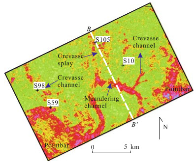
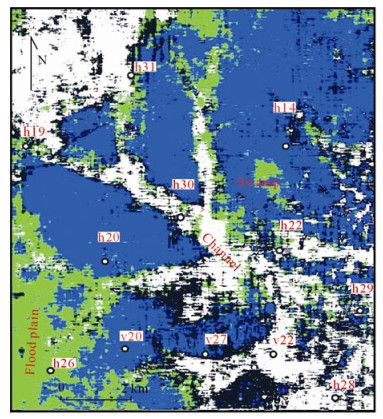
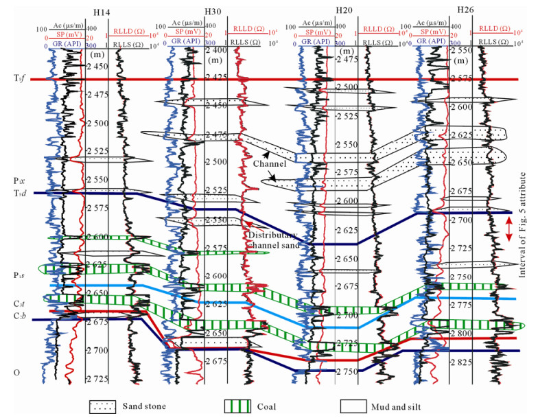
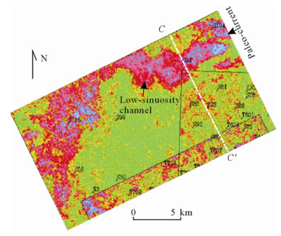
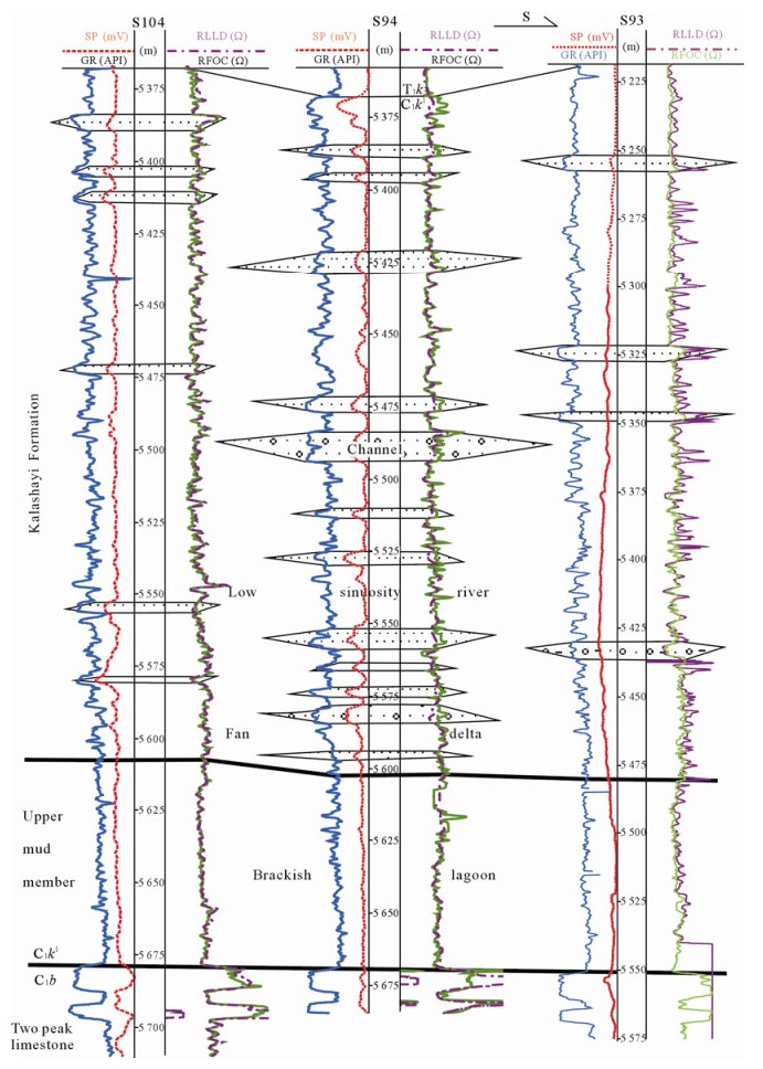
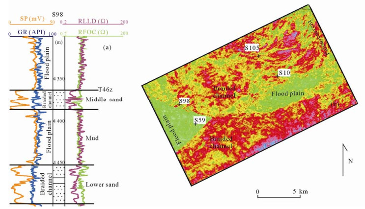
  • It is easy to identify ancient fluvial morphologic types by the outcrop, log and core data. However, the horizontal distribution and geometry of the channels can only be identified and predicted by relying on the 3-D seismic data. The 3-D seismic horizon slices, especially, can play an important role in the sandstone prediction of meandering rivers, distributary channels and low-sinuosity channels. Every microfacies unit, including main channels, such as sinuous or branching channels, levee, crevasse channels, ligule crevasse splay and floodplain etc. can be identified. Braided channel sandstones are planar tabular lateral-connected sandbodies and the distribution of thick main channel belts can only be identified from 3-D seismic data. As the braided sandstones are ubiquitous, their occurrence and distribution do not need to be predicted. Generally, the coal velocity is so low that it can create a strong amplitude reflection in coal strata. It consequently conceals the amplitude respondence to anastomosing channel sandstone which could be identified from 3-D seismic inversion data sometimes. Case studies of mud-rich low-sinuosity rivers identified with 3-D seismic data indicate that the scales and width-to-thickness ratio of such sandbodies are small, laterally unconnected, and generally occurred on distant or further parts of an alluvial fan under dry climate conditions. Sometimes extraction of seismic attributes of every reflection event along horizons is expected to maximize expression of the spatial evolutions of ancient channels.


  • Since 3-D seismic data are used to interpret the sedimentary system, people have been able to identify the morphologic channel types, sandbody distribution and scale as the modern rivers are observed using satellite pictures or airscapes. A lot of typical meandering rivers, distributary rivers, anastomosing rivers and straight rivers are recognized on the 3-D seismic horizon slices (Brown, 1999). As the coverage area of 3-D seismic survey increases, there are more and more actual examples displaying the planar geometry and sandbody distribution of ancient fluvial channels. Although the channel morphologic type of the fluvial deposition can be deduced based on its sedimentation characteristics, the distribution of the channel sandstone between and/or outside the wells usually has to be identified by 3-D seismic data when the wells are rare. This article introduces the explanation for the morphologic type and sandbody planar distribution with 3-D seismic data when a layer of a given region is confirmed to be fluvial sedimentation by borehole information. It should be indicated that the morphologic type of river could not be detected using 2-D seismic data even on a 0.5 km×1 km survey because of the limited horizontal resolution. The width of a lot of sandstones of a single channel is less than 1 km (Reynolds, 1999). 2-D seismic explanation can only help to identify and determine some large depositional system frameworks, such as fan systems, delta systems, fluvial systems, etc..

    In most cases, 3-D seismic horizon slices can be used to reflect the morphology, scale, microfaciesunit, etc., of a fluvial channel. Generally, there is more mud than sand on a stratigraphic section and the velocities of sandstones are different from that of mudstone; therefore, the strong amplitude reflects the planar location of the channel and the sandstone. When the amplitude attributes do not work, such as when there are low-velocity coal beds or evaporation salts, or when there are high-velocity igneous rocks, gypsum or carbonate rocks, the horizon amplitude map reflects the existence and thickness of these special rocks (when the thickness is less than 1/4 wavelength) rather than the morphologic and sandbody distribution of the channel. Then, other seismic attributes can be employed, such as waveform, reflection strength slope, amplitude acceleration, inversion parameter, etc., instead of horizon slices, to get some results.

    An event is the smallest strata unit of the seismic strata that are recognizable. To best refine the research accuracy, it is used as the unit when extracting the attributes. It can be either the wave crest or the trough, with respect to the reflection of half a cycle, or 1/4 wavelength, corresponding to 30–50 m strata thickness on the normal seismic section. In most cases, it does not matter how the horizon of a borehole channel sandstone is calibrated at the wave crest or wave trough or in between, the horizon slice extracted along the wave crest or trough is similar or close, especially when the channel sandstone thickness is bigger, e.g., 15–30 m, or the wave impedance difference between the channel sandstone and floodplain mudstone is bigger. When the channel is small and the channel sandstone thickness is thinner, there will be obvious difference between the horizon slices of the bordering wave crest and trough, reflecting the evolution of depositional microfacies of two periods. The time window suggested by Landmark software user's guide when extracting the attributes is normally 50–200 ms, bigger than the scale of an event (about 30 ms). A big time window is helpful in identifying the existence and planar location of the river channel, but is not suitable for understanding the accurate horizon of the channel development. Choosing a big time window or a small one shall be dependent on the result of the well depositional facies analysis and required research accuracy.

    When a 3-D seismic survey is bigger, the morphologic type and sandbody microfacies distribution can normally be displayed along a horizon slice. For example, the 3-D seismic coverage of the Tahe Oilfield is over 2 000 km2, the morphologic type and distribution of the main Triassic channel can be generally seen along the horizon slice (Pu, 2007). However, when the 3-D seismic field is smaller, such as from dozens of square kilometers to between one and two hundred square kilometers, the distribution of the main channel can hardly be seen on the horizon slices. This is because the ancient main channel may not be in this range, or on the event from which the attribute is extracted. Therefore, in order to understand the distribution of the main channel, extracting the horizon slices of every event in the target section may help to get the channel distribution that possibly developed in any period of the target section and explore the contained depositional information in the seismic data.

    The modern braided river is a multi-channel system dominated with bedload sediments, and the channel of different periods lies side by side. However, for the reserved ancient braided channel or braided delta, the sandstones are mostly sandbodies with thickness of dozens of meters, with constant distribution in an area of thousands or tens of thousands of square kilometers (McPherson et al., 1987; Miall, 1977). They form one or two events in the seismic section. Normally, you cannot see the channel system if the 3-D seismic survey is not big enough, such as the lower Guantao Formation in Huanghua depression, the Chang 10 sandstone of Yanchang Formation, Yan'an Formation in Ordos basin, lower Sangonghe Formation and Badaowa Formation in Junggar basin (Zhong et al., 2006; Pu, 1994; Pu et al., 1994a, 1993), and the three Triassic sandbodies of Tarim basin (Wang and Ren, 1999). However, when the cumulative thickness of the sandstone is less than 30–50 m that an event time window typically represents, the horizon slice generally reflects the changes in thickness of the braided river sandstones. Sometimes, the stripes of thickened cha nnel sandstone are radially stretched on a plane, reflecting the distribution of the main channel. When a sandbody of the braided river or braided delta pinches out, a planar smooth pinchout line will form between the sand and the lacustrine or floodplain mud. Accordingly, a seismic event termination or amplitude weakening happens. Middle–Upper Triassic in the Tahe Oilfield in the Tarim basin contains three sandbodies known as S sand, Z sand and X sand, from the top to the bottom; and on seismic sections the sand tops are respectively calibrated at the T46s, T46z, and T46x interface reflections. Except for some meandering channel depositions occurring at the basal S sand, the three sandbodies all belong to braided channel or braided delta depositions (Pu et al., 2007). Z sand is 25–40 m thick, and consists of NEE-SWW braided channel sandstones. Two layers of 50–60 m mudstones underlie and superimpose it (Fig. 1a). On the horizon slice of the Z sand (T46z), the braided channel sandstones are uniformly distributed extensively and laterally. A smooth pinchout line of the braided channel sandstones separates the braided channel area from the floodplain area and no levee and crevasse splays etc. are preserved (Fig. 1a). On the seismic section, the sandstone pinchout corresponds to the termination of a peak event (Fig. 2). Such tabular braided channel sandstones mainly serve as reservoirs in structural traps.

    Figure  1.  The log response of Middle Triassic braided stream of Well S98 and middle sand (T46z) distribution on the horizon slice along T46z interface. See the corresponding seismic section on Fig. 2.
    Figure  2.  The termination of braided channel sandstones and high amplitude of a pointbar of meandering channel. See Fig. 3 for the section location.

    Since the width of a pointbar sandbody was formed by lateral acretion and bending, the cut can be as large as several kilometers, which is much wider than the width of a single meandering channel (less than 1 km). Therefore, the pointbar sandbody of a meandering river can be used as a reservoir unit with a quite large scale. Although it is lenticular, the scale is usually larger than that of some distributary channels or anastomosing channels. Therefore, it is also the main type that forms oil and gas reservoirs, such as the Qingshankou Formation in South Songliao basin, upper Guantao Formation in Jiyang depression, upper Shihezi Formation and Yanchang Formation in Ordos basin, and Upper Triassic sandstone in Tahe Oilfield etc., where numerous reservoirs consist of pointbar sandstones of meandering rivers.

    The single pointbar sandbodies on the 3-D horizon slice are usually U-shaped or have irregular ellipse patterns. Several planar U-shaped pointbars are generously connected by narrower meandering river. The Upper Triassic sandstone reservoir of Tahe Oilfield is of the meandering channel deposition type. The lateral accreted pointbar and channel sandstone are shown as strong amplitude reflection on the seismic section (Fig. 2). It is narrow on the section and distributed in a lenticular pattern. On the horizon slice, the channel sandstone has a typical meandering distribution with pointbars formed by lateral accretion, avulsion channels and avulsion splay (Fig. 3).

    Figure  3.  The horizon slice of Triassic T46s2 interface of Langa 3-D seismic survey, showing meandering channel and a pointbar.

    Anastomosed streams are a web pattern channel system sharing a solid floodplain with developed plants, in which a single riverbed is stable and straight. The sediment section can either be a dualistic member structure formed by the base load and suspended load, or a singular member structure with suspended load only. The base load sandbody can either have a sheet or broad distribution over a larger area, or a lens with smaller area (Wang and Ren, 1999). The ancient anastomosing fluvial sediment usually coexists with swamp coal, such as the Xishanyao Formation in Junggar basin and Tuha basin (Pu et al., 1994a, 1993), and the upper part of the upper Shanxi Formation in Ordos basin are all typical sediments of coal system and anastomosing river. Oil and gas reservoirs are found in the respective layers in these three regions, but the seismic identification of sandstone reservoir is still very difficult, and there are almost no effective methods so far. The reason is that the velocity of the coal layer is very low, around 2 000–2 800 m/s only, which is far lower than the velocity of the mudstone that is around 3 000–4 000 m/s. The contribution of coal wave impedance difference from the upper and lower strata is much higher than that of sandstone and other stones. Therefore, the 3-D horizon slices, waveform classification and other related attributes are not effective to identify the existence and distribution of the channel sandstone, yet it generally reflects the thickness and distribution of the coal layer. As a result, it is still difficult to identify and predict the anastomosing channel in the ancient coal system by 3-D seismic data.

    In the shallowly buried semisolid sediment, the velocities of the coal and the mudstone are close to each other; or when coal is very thin, 3-D seismic horizon slices can also display the planar geometry and microfacies distribution of ancient anastomosing rivers. The lower part of the Yan'an Formation in northern Ordos basin consists of anastomosing stream deposition and coal strata. In spite of numerous coal beds, the cumulative coal thickness is quite small (< 10 m). The channel sandstone velocity is bigger than that of mudstones, and thicker main channel sandstones (>20 m) substantially contribute to the amplitude. The geometry of anastomosing streams, therefore, can still be seen on 3-D seismic attribute map. Figure 4 is a waveform classification map of basal Yan'an Formation (T5 to 20 ms up) of Daniudi Gasfield in northern Ordos basin. Buried at a depth of 600–800 m and interbedded with numerous but in total very thin coal beds, the sandstones show characteristics of anastomosing channels flowing northwest, between which are the irregular shapes of swamps and flood plain Figure 4. A waveform classification map of basal Yan'an Formation (T5 to 20 ms up) of Daniudi Gasfield in northern Ordos basin, showing an anastomosing fluvial system. microfacies. From an angle of planar geometry, the river shown in Fig. 4 looks, to some extent, like a distributary river system discussed below. A more classical ancient anastomosed drainage might be like the one shown by Brown (1999). It is seen on a horizon slice in Jeanned Arc, East Canada. Its web pattern multi-channel, shared bank and abandoned lake microfacies unit are very similar to the characteristics of modern anastomosing streams (Brown, 1999).

    Figure  4.  A waveform classification map of basal Yan'an Formation (T5 to 20 ms up) of Daniudi Gasfield in northern Ordos basin, showing an anastomosing fluvial system.

    The four river patterns of Miall (1977) are braided river, meandering river, anastomosing river, and straight river, without the category of distributary channels. However, 3-D seismic data may sometimes display some distributary channels spreading radially, roughly equal to the distributary channel or estuary bar sandbody on the delta or fan edge. The distributary channel displayed by the 3-D horizon slice often reflects that the sandstone reservoir is also distributary. Sometimes, when the curvature of a single channel is bigger, some pointbar sandbodies can also develop. Figure 5 is the 3-D seismic horizon slice of upper Shanxi Formation of Daniudi Gasfield in Ordos basin, displaying a delta distributary channel flowing to wards the Southwest. On the well-linked cross section, the upper Shanxi Formation on Well H30 has a layer of channel sandstone, 7 m more than other wells of the same interval (Fig. 6).

    Figure  5.  A horizon slice of Daniudi 3-D seismic survey, upper Shanxi Formation.
    Figure  6.  The north-east H14-H30-H20-H26 well-linked cross section of Heigemiao survey. The GR logging displays that at a depth of 2 550 m, Well H30 has a 7 m distributary channel sand which is more than the same layer of the neighboring well.

    The low-sinuosity channel is the river whose ratio of channel length to river valley length is less than 1.5. It is also called the straight river. This article mainly concerns about the low-sinuosity channels except for braided ones, i.e., the mud-rich low-sinuosity channel called by Galloway and Hobday (1986). For a long time, since there are no effective methods to determine the curvature of the ancient river, there have been very few reports on the ancient low-sinuosity channel. However, with the growth and explanation of 3-D seismic data, the morphology of many ancient channels can be clearly identified on the 3-D seismic horizon slices, showing substantial information about the characteristics of the ancient low-sinuosity channel. Through the 3-D seismic data, the authors identified the low-sinuosity channel of Lower Carboniferous Kalashayi Formation in Tarim basin, upper Shihezi to Ermaying formations in Ordos basin, Quantou Formation in South Songliao basin, and Lower Cretaceous Shishugou Group in Junggar basin (Pu et al., 1994b). Here, their characteristics and differences are summarized.

    The Lower Carboniferous Kalashayi Formation in the Tahe region is low-sinuosity fluvial sand-mud interbedded deposition with mixed-color (He et al., 2004). The sandstone content on the well column section is 10%–30%, partially containied terrestrial clastic conglomerate and breccia, with the characteristics of fan edge—lower fan. In the Tahe Aidin 3-D seismic survey, the background of the seismic reflection is normally weak amplitude, with some medium-strong amplitude partially appearing (Fig. 7). On the horizon slice, the strong amplitude is generally displayed as a characteristic of low-sinuosity channel. The channel belt is 4–5 km wide, and the length is longer than 25 km, with typical low-sinuosity channel morphology (Fig. 8). Well S94 is on the channel. Comparing with other wells, the sandstone content of Kalashayi Formation on S94 has clearly increased, taking up 35% of the section. However, it is still featured in the interbedded sand-mud layer. The thickness of a single sandbody is still smaller, normally around 3–7 m, showing the characteristic that the channel and flood plain cross each other frequently. On other wells such as S104 and S93 outside the channel belt, the channel sandstone of Kalashayi Formation takes a small proportion around 5%–10% only, mostly consisting of avulsion channel (Fig. 9). These characteristics suggest that the low-sinuosity channel on the horizon slice is actually a main channel belt.

    Figure  7.  The middle amplitude reflection of Lower Carboniferous Kalashayi Formation straight channel belt in Aidin 3-D seismic survey.
    Figure  8.  The high amplitude distribution of a lowsinuosity channel belt of Lower Carboniferous Kalashayi Formation in Aidin 3-D seismic survey.
    Figure  9.  Sandstones are accumulated much more on the low-sinuosity channel belt bored by Well S94 than overbank bored by Wells S104 and S93.

    The ancient mud-rich low-sinuosity rivers are mostly multi-channel systems, mostly with the above-mentioned distributary characteristics. Sometimes, the sinuosity of an ancient river is dependent on the climate, source rocks, and topography during the ancient times (Wright and Marriott, 1993). Mud-rich low-sinuosity channel is generally developed in the proximal terrestrial area under the dry-semidry climate. The channels are generally stable and straight, flowing smoothly, while the width-depth ratio is smaller.

    According to the recognition on regional depositional facies background in Ordos basin, and the analysis of well section and 3-D seismic facies in the Daniudi region, the Permian Shihezi Formation to Middle Triassic Ermaying Formation mainly developed low-sinuosity channel sedimentation (Fig. 10). On the well-linked cross-sections, the sandstones are mostly lenticular and sandwiched in the mudstone, with the base sharply transformed from mudstone. It can be shown by analyzing the 3-D seismic horizon slice and well cross section. The sandstone content of the channel is higher than that on the sides in the same time period.

    Figure  10.  Mud-rich low-sinuosity channels of Upper Triassic Heshanggou Formation, Taigemiao Gasfield.

    There are some common characteristics of the channel sandbodies of the upper Shihezi Formation to Ermaying Formation in this area. That is, they are all red-mixed color sandstones under dry climate, interbedded among the mudstones. The bedload sandstone content on the section is low (less than 22%), belonging to the mud-rich low-sinuosity channel of Galloway (1983). However, from a planar view, the area percentage of channel sandstone of these rivers is not low, around 27%–46%. It may reflect that the lateral connection of mud-rich low-sinuosity channel sandstone is better than the vertical connection. However, it is just a phenomenon based on 3-D seismic resolution.

    The channel of 3-D seismic slice actually shows a relatively developed channel area with a thicker sand interval within the scale of a seismic event. The well cross-section shows that the single thickness of a channel sandstone is normally 3–5 m. Therefore, Fig. 10 shows the characteristics of a composite channel belt of the area, whose width is larger than the width of a single channel.

    The Lower Cretaceous Quantou Formation in Changlin depression in Songliao basin is mainly a set of red fluvial interbedded sandstone and mudstone which are distributed widespread. The depositional center is around Qian'an area east of the research area. The river ran from northwest to southeast. The lithology is partially brown-gray, and brown, gray-green, brown white mudstone, siltstones, fine, midlle and coarse sandstone, and pebbles. They are mainly rockdebris sandstones. The sorting and roundness are both relatively poor, with the characteristics of fast flood deposition on fan edges.

    The seismic attribute map of Changlin depression in Songliao basin shows that Quan 1 to Quan 3 are all low-sinuosity fluvial deposition. As displayed by Quan 3 3-D horizon slice, the channels displayed by the strong amplitude are characterized by a lowsinuosity to straight system, which consists of multichannel branching slightly southward (Fig. 11).

    Figure  11.  Daerhan depression 3-D field Quantou Section 3 T21 ±15 ms root mean square amplitude map.

    Comparing the low-sinuosity channels discussed above in these three basins, it is found that they share some common characteristics: (i) all of them are mixed colored or red sedimentation in dry climate, with calcium nodules commonly seen; (ii) all of them are mud-rich rivers, the base-load sand content less than 15%; (iii) all of them have some sedimentation characteristics of alluvial fan edge or environment adjacent fan edge, sometimes interbedded with gravity flow conglomerates of dozens of centimeters to several meters. On the plane, it overlaps on the fan edge deposition, or is adjacent to the alluvial fan but to the more downstream direction; (iv) the single sandstone is small. The thickness is usually less than 5 m, and the width is less than 500 m, unconnected. Entrapped with oil or gas, the separate sandstone lenses normally form lithologic pools. After perforated and put into production, the output and pressure of a pool decrease rapidly; (v) on the 3-D seismic slice, straight, low-sinuosity or distributary channel belts are commonly seen, which represent a combination of multiple channel sandstones and the flood plain sedimentation with the total thickness around 30–50 m. The width of a channel belt can be 1–2 km. The length can be 10–30 km, and the sinuosity (ration of channel length to the river valley length) can be 1–1.5. Strata disclosed by the drilled well on the main channel belt are not solely composed of sandstones. The sandstone percentage is relatively high, with 40%–60% being the highest. It is 25%–45% higher than that of the same strata disclosed by the drilled well outside the main channel.

    3-D seismic analysis is very useful in identifying the planar morphologic type of ancient channels, and predicting the sandbody distribution. Under the known fluvial facies, the results of predicting the underground ancient channel sandbodies, with or without 3-D seismic data, are very different. For meandering rivers, distributary channels, low-sinuosity channel, or straight channel, 3-D seismic data will be effective in identifying and predicting the sandbody distribution. However, the need for or effect of using 3-D seismic data will decrease when identifying and predicting the sandbody of braided channels and anastomosing channels in coal strata.

  • Brown, A. R., 1999. Interpretation of Three-Dimensional Seismic Data. AAPG Mem. , 42: 97–188
    Galloway, W. E., Hobday, D. K., 1983. Terrigenous Clastic Depositional Systems—Application to Petroleum, Coal, and Uranium Exploration. Springer-Verlag, New York. 45–68 http://dancecenter-spa.com/Terrigenous-Clastic-Depositional-Systems--Applications-to-Petroleum--Coal--and-Uranium-Exploration.pdf
    He, F. Q., Zhai, X. X., Yu, R. L., et al., 2004. Deposition and Genetic Analysis of Carboniferous Kalashayi Formation in Tahe Oilfield. Oil and Gas Geology, 25(3): 258–262 (in Chinese with English Abstract) http://en.cnki.com.cn/Article_en/CJFDTOTAL-SYYT200403003.htm
    McPherson, J. G., Shanmngan, G., Moiola, R. J., 1987. Fan-Deltas and Braided Deltas. Geol. Soc. Amer. Bull. , 99: 331–340 doi: 10.1130/0016-7606(1987)99<331:FABDVO>2.0.CO;2
    Miall, A. D., 1977. A Review of the Braided-River Depositional Environment. Earth-Science Review, 13(1): 1–62 doi: 10.1016/0012-8252(77)90055-1
    Pu, R. H., 1994. Preliminary Research on Investigating Relative Thickness of the Sand Body at the Bottom of Sangonghe Formation Using Seismic Amplitude Information. Geophysical Prospecting for Petroleum, 33(2): 66–74 (in Chinese with English Abstract) http://en.cnki.com.cn/Article_en/CJFDTOTAL-SYWT199402008.htm
    Pu, R. H., 2007. The Typical Seismic Facies in Tahe Oilield. Oil Geophysics Prospecting, 42(3): 308–314 (in Chinese with English Abstract) http://en.cnki.com.cn/Article_en/CJFDTOTAL-SYDQ200703012.htm
    Pu, R. H., Mei, Z. C., Tang, Z. H., 1993. Seismic Facies Analysis of Xishanyao Formation in Eastern Junggar Basin. Petroleum Exploration and Development, 20: 57–60 (in Chinese with English Abstract)
    Pu, R. H., Mei, Z. C., Tang, Z. H., 1994a. Seismic Facies of Jurassic in Eastern Junggar, Xinjiang, China. Oil & Gas Geology, 15(3): 241–247 (in Chinese with English Abstract)
    Pu, R. H., Mei, Z. C., Tang, Z. H., 1994b. Division of Seismic Sequences and Interpretation on Sequence Stratigraphy of Shishugou Group, Cainan Area, Junggar Basin, Xinjiang, China. Earth Science—Journal of China University of Geosciences, 19(6): 769–777 (in Chinese with English Abstract) http://en.cnki.com.cn/Article_en/CJFDTOTAL-DQKX199406007.htm
    Reynolds, A. D., 1999. Dimensions of Paralic Sandstone Bodies. AAPG, 83(3): 211–229
    Wang, S. J., Ren, M. D., 1999. A New Classification of Fluvial Rivers according to Channel Platform and Sediment Characteristics. Acta Sedimentologica Sinica, 17(2): 240–246 (in Chinese with English Abstract) http://en.cnki.com.cn/Article_en/CJFDTOTAL-CJXB902.012.htm
    Wright, V. P., Marriott, S. B., 1993. The Sequence Stratigraphy of Fluvial Depositional Systems: The Role of Floodplain Sediment Storage. Sedimentary Geology, 86(3–4): 203–210
    Zhong, H. L., Pu, R. H., Han, Q., 2006. Braided River-Braided Delta Deposition of Sand Set Chang 10 of Yanchang Formation in LYD Area of Ordos Basin, North China. Science Journal of Northwest University Online, 4(1): 1–6 (in Chinese with English Abstract)
  • Relative Articles

    [1]Lidong Zhang, Changzhou Deng, Yao Tang, Xinran Ni, Bizheng Yang, Shanshan Liang, Weipeng Liu, Jishuang Ding, Xiaohui Zeng. Pyrite Geochemistry and S-Hg Isotopes Reveal the Ore Genesis of the Hydrothermal Vein-type Cuiluan Ag-Pb-Zn Deposit in NE China[J]. Journal of Earth Science. doi: 10.1007/s12583-025-0201-x
    [2]Shengru Yue, Lunche Wang, Qian Cao, Jia Sun. Assessment of future cotton production in the Tarim River Basin under climate model projections and water management[J]. Journal of Earth Science. doi: 10.1007/s12583-025-0213-6
    [3]Yiqiu Yan, Changbao Guo, Wenkai Chen, Zhendong Qiu, Caihong Li, Hao Yuan, Xinxia Yuan. Deformation Characteristics and Mechanisms of Large Deep-Seated Slow-Moving Landslides in Active Fault Zones: Insights from the Renniang River Watershed of the Jinsha River Fault, Tibetan Plateau[J]. Journal of Earth Science. doi: 10.1007/s12583-024-0158-1
    [4]Wenjie Pan, Cui Gan, Jiachun Yang, Hui Liu, Li Zhang, Lifen Liu, Lei Tong. Fate of oxytetracycline mediated by iron redox in simulated river-groundwater interactions[J]. Journal of Earth Science. doi: 10.1007/s12583-025-0228-z
    [5]Ruihuan Su, Daoyang Yuan, Jinchao Yu, Hong Xie, Zhao Wu, Lijun Zhang. Comprehensive Study of the 734 A.D. Tianshui Earthquake in the Western Qinling Area and Assessment of Regional Seismic Risk[J]. Journal of Earth Science. doi: 10.1007/s12583-025-0218-1
    [6]Xiangchun Wang, Bing Nie, Zhiyu Wu, Weiwei Wang, Hua Chen. Identification and Characteristics Analysis of Micro-Seismic Signals in the Haima Seep Area[J]. Journal of Earth Science, 2024, 35(1): 288-291. doi: 10.1007/s12583-024-1968-x
    [7]Jile Chen, Peimin Zhu, Yuefeng Yuan, Guifan Chen. Formation of the Tibetan Plateau during the India-Eurasia Convergence: Insight from 3-D Multi-Terrane Thermomechanical Modeling[J]. Journal of Earth Science, 2024, 35(1): 112-130. doi: 10.1007/s12583-023-1931-0
    [8]Peng Guan, Cuifa Shao, Yuyong Jiao, Guohua Zhang, Junpeng Zou, Fei Tan. 3-D Tunnel Seismic Advance Prediction Method with Wide Illumination and High-Precision[J]. Journal of Earth Science, 2024, 35(3): 970-979. doi: 10.1007/s12583-021-1503-2
    [9]Dandan Zheng, Yuhui Gui, Jian Kuang, He Bing. Downstream Channel Evolution and Its Causes in the Yuan River during the Qing Dynasty[J]. Journal of Earth Science, 2023, 34(4): 1263-1271. doi: 10.1007/s12583-021-1600-2
    [10]Xu Lin, Chang’an Li, Jing Liu-Zeng, Jovliet Marc, Haijin Liu, Lingling Li, Chengwei Hu, Xiaokang Chen, Jixin Chen. Detrital zircon U-Pb age analysis of Late Pliocene deposits from the lower Yangtze River, South China: Implications for sedimentary provenance and evolution of the Yangtze River[J]. Journal of Earth Science. doi: 10.1007/s12583-023-1961-9
    [11]Xiuchang Zhu, Yongbo Wang, Xinyue Dang, Huan Yang, Shucheng Xie. Spatiotemporal Distribution of Microbial Tetraether Lipids in a Lake and Its Inflowing River: Implications for the Identification of Flooding Events[J]. Journal of Earth Science, 2022, 33(6): 1601-1613. doi: 10.1007/s12583-021-1552-6
    [12]Sanming Lu, Xueyi Lan, Lili Zhao, Zanzan Zhang, Xiaoyong Yang, Zhuang Zhao, Dong Guo, Xiaochun Xu, Yongsheng Wang, Jianshe Li, Huasheng Qi. A 3D Investigation of Geological Structure and Its Relationship to Mineralization in the Nanling-Xuancheng Ore District, Middle-Lower Yangtze River Metallogenic Belt, China[J]. Journal of Earth Science, 2022, 33(3): 664-680. doi: 10.1007/s12583-021-1577-x
    [13]Hongwei Liang, Xiaoqing Zhao, Longxin Mu, Zifei Fan, Lun Zhao, Shenghe Wu. Channel Sandstone Architecture Characterization by Seismic Simulation[J]. Journal of Earth Science, 2019, 30(4): 799-808. doi: 10.1007/s12583-017-0971-x
    [14]Mohammad Ali Faraji, Ali Kadkhodaie, Reza Rezaee, David A. Wood. Integration of Core Data, Well Logs and Seismic Attributes for Identification of the Low Reservoir Quality Units with Unswept Gas in the Carbonate Rocks of the World's Largest Gas Field[J]. Journal of Earth Science, 2017, 28(5): 857-866. doi: 10.1007/s12583-017-0800-2
    [15]Bo Xu, Ancheng Xiao, Lei Wu, Liguang Mao, Youpu Dong, Lijun Zhou. 3D Seismic Attributes for Structural Analysis in Compressional Context: A Case Study from Western Sichuan Basin[J]. Journal of Earth Science, 2014, 25(6): 985-990. doi: 10.1007/s12583-014-0497-4
    [16]Renhai Pu, Lu Yun, Jiangyu Su, Qian Guo, Xiaohong Dang. Growth Conditions and 3-D Seismic Delineation of Carboniferous Barrier Reefs in the Southwestern Tarim Basin[J]. Journal of Earth Science, 2014, 25(2): 315-323. doi: 10.1007/s12583-014-0429-3
    [17]Jiannan Luo; Wenxi Lu; Xin Xin; Haibo Chu. Surrogate Model Application to the Identification of an Optimal Surfactant-Enhanced Aquifer Remediation Strategy for DNAPL-Contaminated Sites[J]. Journal of Earth Science, 2013, 24(6). doi: 10.1007/s12583-013-0395-1
    [18]Shishu Xiong, Liting Huang, Jinfeng Chen, Jingsu Su. Multi-dimensional Seismic Response Analysis of Base-Isolated Frame Structure with 3D Isolator[J]. Journal of Earth Science, 2005, 16(1): 66-71.
    [19]Yin Chen, Peisen Miao, Jianguo Li, Ruoshi Jin, Hualei Zhao, Lulu Chen, CongWang, Haoyu Yu, Xiaoru Zhang. Association of Sandstone-Type Uranium Mineralization in the Northern China with Tectonic Movements and Hydrocarbons[J]. Journal of Earth Science. doi: doi.org/10.1007/s12583-021-1493-0
    [20]Ruoshi Jin, Huajian Liu, Xiaoguang Li. Theoretical System of Sandstone-Type Uranium Deposits in Northern China[J]. Journal of Earth Science. doi: doi.org/10.1007/s12583-021-1449-4
  • Created with Highcharts 5.0.7Amount of accessChart context menuAbstract Views, HTML Views, PDF Downloads StatisticsAbstract ViewsHTML ViewsPDF Downloads2024-052024-062024-072024-082024-092024-102024-112024-122025-012025-022025-032025-0402.557.510
    Created with Highcharts 5.0.7Chart context menuAccess Class DistributionFULLTEXT: 43.0 %FULLTEXT: 43.0 %META: 56.4 %META: 56.4 %PDF: 0.5 %PDF: 0.5 %FULLTEXTMETAPDF
    Created with Highcharts 5.0.7Chart context menuAccess Area Distribution其他: 2.6 %其他: 2.6 %Brazil: 0.5 %Brazil: 0.5 %China: 61.4 %China: 61.4 %Egypt: 0.5 %Egypt: 0.5 %India: 0.5 %India: 0.5 %New Zealand: 0.8 %New Zealand: 0.8 %Reserved: 1.0 %Reserved: 1.0 %Russian Federation: 6.6 %Russian Federation: 6.6 %United States: 26.0 %United States: 26.0 %其他BrazilChinaEgyptIndiaNew ZealandReservedRussian FederationUnited States

Catalog

    通讯作者: 陈斌, bchen63@163.com
    • 1. 

      沈阳化工大学材料科学与工程学院 沈阳 110142

    1. 本站搜索
    2. 百度学术搜索
    3. 万方数据库搜索
    4. CNKI搜索

    Figures(11)

    Article Metrics

    Article views(411) PDF downloads(48) Cited by()
    Proportional views
    Related

    /

    DownLoad:  Full-Size Img  PowerPoint
    Return
    Return