Advanced Search

Indexed by SCI、CA、РЖ、PA、CSA、ZR、etc .

2009 Vol. 20, No. 5

Display Method:
 
Lithogeochemistry of Volcanic Rocks and Hosted Melt Inclusions in Wudalianchi, Heilongjiang, China
Ni Li, Qicheng Fan, Qian Sun, Rubo Sun
2009, 20(5): 771-783. doi: 10.1007/s12583-009-0067-3
Abstract:

Wudalianchi (五大连池) volcanoes are famous Quaternary ones with fairly good volcanic landscape in Northeast China. The volcanic rocks are phonotephrite, tephri-phonolite, trachyandesite, and basaltic trachyandesite with SiO2 contents of 47.3 wt.%–54.2 wt.%. The characteristic of high K2O content in Wudalianchi volcanic rocks suggests that they probably share a common potassic magma source. The magma evolutions of Wudalianchi volcanic rocks are similar, while the new eruption products of Laoheishan (老黑山) and Huoshaoshan (火烧山) volcanoes are slightly more evolved than the old eruption materials, i.e., the magma of the new eruptions in 1719–1721 from the above two volcanoes is the evolved magma in underground chamber. The main phenocrysts of Wudalianchi volcanic rocks are olivines, clinopyroxenes, and some characteristic K-rich leucites. The various-shaped melt inclusions are found in olivine phenocrysts from new eruption products of Laoheishan and Huoshaoshan volcanoes. By electron microprobe (EMP) analyzing, the contents of SiO2 and total alkali show a wide range, suggesting that the pre-eruptive magma was probably more complicated, or the melt inclusions were rather unhomogeneous. On the basis of EMP results, it is believed that the sulfur degassing rate from this new eruption was much higher than that of the millennium eruption of Tianchi (天池) volcano, while the chlorine degassing rate was a magnitude lower than that of Tianchi volcano.

Detrital Composition of Lower–Middle Jurassic Sandstones from Huangshi, Hubei: Implication for Provenance Types and Geotectonics
Jianghai Yang, Yuansheng Du, Yongjun Qin, Xuefeng Bai
2009, 20(5): 784-796. doi: 10.1007/s12583-009-0068-2
Abstract:

The detrital modes of the sandstones from the south basin of Dabie (大别) orogenic belt during the Early-Middle Jurassic are complex due to multiple supplying. Detrital compositions of medium-coarse sandstones from the Lower-Middle Jurassic, Huangshi (黄石), show three main provenances: recycled ororgen, volcanic arc (arc orogen), and continental block on the bases of the Dickinson discriminating diagrams of modal composition and analysis of sandstone petrofacies. Combined with sparse published paleocurrent data, geotectonic setting of the study area, and the unpublished detrital zircon age data, the positions of the main provenances are inferred as follows: coastal orogenic belt (COB) in the East China provided detritus as the recycled orogen provenance; Dabie orogenic belt (DOB) to the north was the source of volcanic arc (arc orogen) materials; and the continental block clasts were likely from the uplift of the Yangtze basement (UYB) (Jiangnan (江南) uplift). Six sedimentary cycles are recognized in the studied section, one in Wuchang (武昌) Formation, and five in Huajiahu (花家湖) Formation. During the deposition, the three main provenances play different roles. The quantitative petrofacies analysis revealed distinct changes of the effect from each source, that is, 61.9% (Cycle Ⅰ)→54.5% (Cycle Ⅲ)→50% (Cycle Ⅳ)→57.9% (Cycle Ⅴ)→14.3% (Cycle Ⅵ), 14.3% (Cycle Ⅰ)→21.2%(Cycle Ⅲ)→40% (Cycle Ⅳ)→36.8% (Cycle Ⅴ)→14.3% (Cycle Ⅵ), and 23.8% (Cycle Ⅰ)→24.2% (Cycle Ⅲ)→10% (Cycle Ⅳ)→5.3% (Cycle Ⅴ)→71.4% (Cycle Ⅵ) from COB, DOB, and UYB, respectively. The results show that (1) COB behaved in considerable activation during the Early Jurassic but weakened in the Middle Jurassic; (2) the vigorous tectonic uplift of DOB initiated in Middle Jurassic; and (3) UYB was in stabilization basically from the Early to Middle Jurassic.

Late Changhsingian (Latest Permian) Radiolarians from Chaohu, Anhui
Biwen Gui, Qinglai Feng, Aihua Yuan
2009, 20(5): 797-810. doi: 10.1007/s12583-009-0069-1
Abstract:

This article reports a radiolarian fauna from the upper Dalong (大隆) Formation, Pingdingshan (平顶山), Chaohu (5DE2;湖), Anhui (安徽) Province, which includes 15 genera and 23 species. One new species, Copicyntra tongi Gui and Feng n. sp., is described. Comparison of the fauna, lithology and biotic associations with those from Meishan (煤山) D and Dongpan (东攀) sections shows that the Dalong Formation in the Pingdingshan Section is deposited in a deep-water shelf basin, about 60–200 m in depth. On the basis of the biotic composition, diversity and morphology, the microfossil fauna from the Pingdingshan Section can be divided into three sedimentary assemblages and the extinction processes of the assemblages are discussed.

New Insight into Oil and Gas Exploration in Miocene and Late Oligocene Strata in Qiongdongnan Basin
Junfeng Yu, Jianxiang Pei, Jing Xu
2009, 20(5): 811-823. doi: 10.1007/s12583-009-0055-7
Abstract:

Oil and gas exploration prospect for the Miocene and Late Oligocene strata in Qiongdongnan (琼东南) basin are evaluated. The structural-sedimentary and reservoir characteristics are discussed and helpful conclusions are drawn. It was proved that there are mainly two reservoir and capping assemblages in Qiongdongnan basin by drilled wells, i.e., one assemblage of the second and the third members of Lingshui (陵水) Formation, upper Sanya (三亚) and Meishan (梅山) formations. According to hydrocarbon evaluation from burial history and well data, all source rocks in Yacheng (崖城) and Lingshui formations have reached the mature-overmature stage. High temperature and overpressure provide dynamic conditions for oil and gas migration, while the long-term activity of basin controlling faults is adverse to their accumulation in upheaved areas. However, because the secondary faults in the basin ceased their activities at the end of the Sanya Period, and the Sanya Formation was later covered by the regional overlying layer of the Meishan Formation, the blocks and low uplifts near the secondary faults were favorable for oil and gas accumulation. Furthermore, as another important pointed area for gas migration, the highest position of a structural ridge should reasonably be a range that is covered by marine mudstone or sandy mudstone during the whole subsiding period, and therefore, the reservoir bed should not be in that position but at its inferior eminence or adjacent slope zone. Therefore, we can draw a conclusion that the inferior low uplifts and structural ridges rather than the upheavals or the top of a structural ridge, probably, have huge reservoirs, and should be chief exploration targets in the Qiongdongnan basin.

Aromatic Hydrocarbons as Indicators of Origin and Maturation for Light Oils from Panyu Lower Uplift in Pearl River Mouth Basin
Xiaowen Guo, Sheng He
2009, 20(5): 824-835. doi: 10.1007/s12583-009-0063-7
Abstract:

Aromatic fractions of six light oils and two source rock samples from Panyu (番禺) lower uplift of Pearl River Mouth basin were analyzed using GC-MS (gas chromatography-mass spectrometric) technique. Thirteen aromatic series of hydrocarbons detected such as biphenyls, naphthalenes, phenanthrenes, dibenzothiophenes (more than two hundred aromatic hydrocarbon compounds) were used to analyze the origin and maturity of the light oils. This study indicates that the distribution of aromatic hydrocarbon compounds in the light oils of wells L1 and P1 differs from those of wells P2, P3 and P4. The light oil samples from wells L1 and P1 contain more dibenzofuran and fluorence hydrocarbons and less naphthalene hydrocarbons. The contents of fluorene, dibenzothiophene and dibenzofuran in the two groups of light oils also show their difference in sedimentary environment. Moreover, the diversity of the relative distributions of biphenyl and naphthalene is apparent between the two groups of light oils. As mentioned above, the origin of the light oils from wells L1 and P1 varies from that of wells P2, P3 and P4. According to the result of oil-source correlation, the light oils from wells P2, P3 and P4 mainly originated from the source rocks in the Enping (恩平) Formation. Accordingly, the light oils from wells L1 and P1 may have been derived from the lacustrine shales in the Wenchang (文昌) Formation or from the mixed source of the Wenchang Formation and the Enping Formation. Applying maturity parameters of methylnaphthalenes, methylphenanthrenes and methyldibenzothiophenes from the aromatic hydrocarbons to the study of the maturity of light oils from Panyu lower uplift indicates that the maturity has reached the high mature stage.

Preliminary Prediction and Evaluation on Source Rock in Low Exploration Basin—A Case Study from the Northeast Depression, South Yellow Sea Basin, East China
Qiang Cao, Jiaren Ye, Wei Wang, Wanzhong Shi, Chunfeng Chen
2009, 20(5): 836-847. doi: 10.1007/s12583-009-0070-8
Abstract:

Low exploration activity fields (e.g., deep formation, deep water, and new exploration areas) are of great importance for petroleum exploration. The prediction of source rocks is critical to the preliminary evaluation of low exploration activity fields, which will determine the early strategic electoral district and decision of exploration activity. The northeast depression is a new exploration area at the South Yellow Sea basin at present. Based on lots of seismic data in the study area and a few of well data in adjacent homologous depression, the early evaluation of source rock in the northeast depression was finished by comprehensively using the techniques of geological analogy, geophysical inversion and basin modeling, and an integrated methodology about preliminary evaluation of source rocks to low exploration activity fields is also presented. The methodology consists of three aspects: (1) prediction of the main formation of major source rocks, based on analogy analysis of seismic reflection characteristics and quality of source rocks in adjacent homologous depression; (2) method of seismic attribution to determine the thickness of source rocks; and (3) prediction of vitrinite reflectance, based on basin modeling technique to determine the maturation of source rocks. The results suggest that the source rock of the Taizhou (泰州) Formation is the most important interval for hydrocarbon generation in the northeast depression, which is characterized as high TOC, fine OM type, huge thickness, and high maturity. The western subdepression is the most important hydrocarbon kitchen in the northeast depression.

Magnetic Properties of Street Dust from Chibi City, Hubei Province, China: Its Implications for Urban Environment
Qingsheng Liu, Qingli Zeng, Tao Yang, Ning Qiu, Lungsang Chan
2009, 20(5): 848-857. doi: 10.1007/s12583-009-0071-7
Abstract:

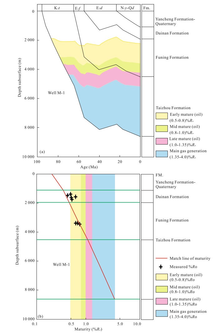
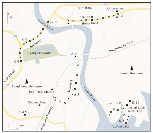
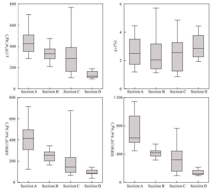
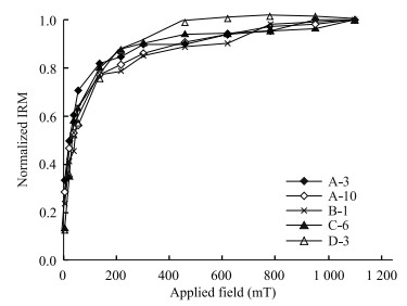
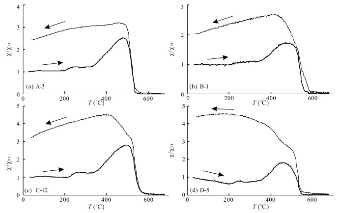
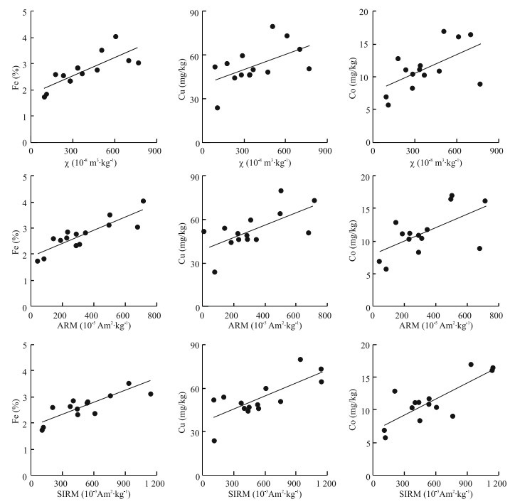
Magnetic measurements and heavy metal analyses were performed on street dusts from the main urban area of Chibi (赤壁) City, Hubei (湖北) Province, China. Results revealed that a PSD/MD (pseudo-single-domain/multi-domain) magnetite-like phase dominates the magnetic phases of the street dust. Concentration-related magnetic parameters, such as magnetic susceptibility (χ), anhysteretic remanent magnetization (ARM), and saturation isothermal remanent magnetization (SIRM) of samples increased in the main roads but appeared lower in the landscape area of the Lushui (陆水) Lake and closely correlated with the concentration of heavy metal Fe, Cu, and Co, and the correlation coefficients are 0.786 for Fe-χ, 0.548 for Cu-χ, and 0.580 for Co-χ, respectively. However, much strong correlations between SIRM and the concentrations of heavy metal suggest that SIRM is a better indicator for heavy metal pollution in the street dust in the study area. The magnetic particles in the street dust are mainly derived from anthropogenic activities, such as vehicle emissions, abrasion of tires, coal combustion, cement works, and building materials. These results make it possible to use magnetic techniques as simple, rapid, and nondestructive tools for assessing the heavy metal pollutions in urbanization process.

3-D Seismic Identification and Characterization of Ancient Channel Morphology
Renhai Pu, Li Zhu, Hongli Zhong
2009, 20(5): 858-858. doi: 10.1007/s12583-009-0072-6
Abstract:

It is easy to identify ancient fluvial morphologic types by the outcrop, log and core data. However, the horizontal distribution and geometry of the channels can only be identified and predicted by relying on the 3-D seismic data. The 3-D seismic horizon slices, especially, can play an important role in the sandstone prediction of meandering rivers, distributary channels and low-sinuosity channels. Every microfacies unit, including main channels, such as sinuous or branching channels, levee, crevasse channels, ligule crevasse splay and floodplain etc. can be identified. Braided channel sandstones are planar tabular lateral-connected sandbodies and the distribution of thick main channel belts can only be identified from 3-D seismic data. As the braided sandstones are ubiquitous, their occurrence and distribution do not need to be predicted. Generally, the coal velocity is so low that it can create a strong amplitude reflection in coal strata. It consequently conceals the amplitude respondence to anastomosing channel sandstone which could be identified from 3-D seismic inversion data sometimes. Case studies of mud-rich low-sinuosity rivers identified with 3-D seismic data indicate that the scales and width-to-thickness ratio of such sandbodies are small, laterally unconnected, and generally occurred on distant or further parts of an alluvial fan under dry climate conditions. Sometimes extraction of seismic attributes of every reflection event along horizons is expected to maximize expression of the spatial evolutions of ancient channels.

Numerical Simulation of Impact on Pneumatic DTH Hammer Percussive Drilling
Changgen Bu, Yegao Qu, Zhiqiang Cheng, Baolin Liu
2009, 20(5): 868-868. doi: 10.1007/s12583-009-0073-5
Abstract:

The process of DTH (down-the-hole) hammer drilling has been characterized as a very complex phenomenon due to its high nonlinearity, large deformation and damage behaviors. Taking brittle materials (concrete, granite and sandstone) as impact specimens, the explicit time integration nonlinear finite element code LS-DYNA was employed to analyze the impact process and the penetration boundary conditions of DTH hammer percussive drilling system. Compared with previous studies, the present model contains several new features. One is that the 3D effects of DTH hammer drilling system were considered. Another important feature is that it took the coupling effects of brittle materials into account to the bit-specimen boundary of the drilling system. This distinguishes it from the traditional approaches to the bit-rock intersection, in which nonlinear spring models are usually imposed. The impact forces, bit insert penetrations and force-penetration curves of concrete, granite and sandstone under DTH hammer impact have been recorded; the formation of craters and fractures has been also investigated. The impact loads of piston-bit interaction appear to be relatively sensitive to piston impact velocity. The impact between piston-bit interaction occurs at two times larger forces, whereas the duration of the first impact doesn't change with respect to the piston velocity. The material properties of impact specimen do not affect the first impact process between the piston and bit. However, the period between the two impacts and the magnitudes of the second impact forces greatly depend on the specimen material properties. It is found that the penetration depth of specimen is dependent on the impact force magnitude and the macro-mechanical properties of the brittle materials.

Hydrochemical and Isotopic Evidence of Origin of Thermal Karst Water at Taiyuan, Northern China
Teng Ma, Yanxin Wang, Qinghai Guo, Chunmiao Yan, Rui Ma, Zheng Huang
2009, 20(5): 879-879. doi: 10.1007/s12583-009-0074-4
Abstract:

Thermal karst groundwaters with temperatures ranging from 32.8 to 62.5 ℃ were found at Taiyuan (太原) City, the capital of Shanxi (山西) Province. To identify the origin of the thermal groundwater, the following tracers were used in this study: δD, δ18O, 4He, 3He/4He, and major chemical constituents in water. Hydrochemical and isotopic data indicate that the thermal groundwaters in the basin area are a mixture of thermal waters from the West Mountain and those from the East Mountain. Furthermore, the 4He and 4Heexc concentrations of the thermal groundwater samples are usually lower than those of the cold groundwater samples, and there is an evidently negative correlation between the temperature and the 4He concentration in thermal groundwaters from the West Mountain and the basin, which means that with the increase in temperature, the He concentration increases in the vapor phase and decreases in the aqueous phase. In the plot of 3He/4He vs. 4He/20Ne of all water samples: air, crust, and mantle, all thermal groundwater samples are distributed near the line between the point of air and that of crust, suggesting that atmospheric and crustal helium is the main source for that in thermal groundwaters. In other words, there are no mantle-derived fluids mixed in the thermal groundwaters.

Measurement of Joint Roughness Coefficient by Using Profilograph and Roughness Ruler
Shigui Du, Yunjin Hu, Xiaofei Hu
2009, 20(5): 890-890. doi: 10.1007/s12583-009-0075-3
Abstract:

Joint roughness coefficient (JRC) is the key parameter for the empirical estimation of joint shear strength by using the JRC-JCS (joint wall compressive strength) model. Because JRC has such characteristics as nonuniformity, anisotropy, and unhomogeneity, directional statistical measurement of JRC is the precondition for ensuring the reliability of the empirical estimation method. However, the directional statistical measurement of JRC is time-consuming. In order to present an ideal measurement method of JRC, new profilographs and roughness rulers were developed according to the properties of rock joint undulating shape based on the review of measurement methods of JRC. Operation methods of the profilographs and roughness rulers were also introduced. A case study shows that the instruments and operation methods produce an effective means for the statistical measurement of JRC.