
Citation: | Sitian Li, Jianye Ren, Fengcun Xing, Zhanhong Liu, Hongyi Li, Qianglu Chen, Zhen Li. Dynamic Processes of the Paleozoic Tarim Basin and Its Significance for Hydrocarbon Accumulation—A Review and Discussion. Journal of Earth Science, 2012, 23(4): 381-394. doi: 10.1007/s12583-012-0262-5 |
The Tarim basin, located in the northwestern China, covers an area of 56×104 km2. It is the largest superimposed basin with the most complicated evolution history in China. From Sinian to Quaternary, this basin received massive deposit fillings, with a maximum depth of bottom surface of basin-fill strata nearly 18 km. The basin is encircled by giant orogens, which is Tianshan orogen at the north margin, West Kunlun orogen at the southwest margin, East Kunlun orogen and Altyn orogen at the southeast margin (He, 2004). Decades of efforts in hydrocarbon exploration and geological research have contributed greatly to the discovery of a giant marine petroleum system and many middle-large oil fields, the majority of which distributed in Paleozoic uplifts and their slopes. The complicated evolution process during the Paleozoic Era has become the focus of exploration and research work of the Tarim basin. In recent years, the petroleum exploration departments have pumped efforts and made achievements in high-precision seismic survey and deep well drilling, providing precious information for investigating the deep-buried Paleozoic strata and revealing their stratigraphic and structural frameworks. Multi-discipline research, especially the investigation on the surrounding giant orogens and tectonic event dating in the past decade, makes them possible to the integrated study of the basin and orogens as a united Earth dynamics system and to discuss some new frontier of basin dynamics (Xu et al., 2011a).
The Tarim basin formed on the Tarim block, which is composed of Pre-Sinian metamorphic basement (Jia, 2004; Wang and Li, 2004). Based on some comprehensive evidences (such as paleo-magnetism), it is deduced that this block originated from the breakup of the East Gondwana paleo-continent and convergence toward the Eurasia after a long distance drifting in NE direction (Boucot et al., 2009; Markello et al., 2006). Because of the regional multi-stage convergence processes in Early Paleozoic, especially the continental collision between the India plate and the Eurasian plate, exert powerful compression to the Tarim block since 65 Ma, both the south and north margins of the lithosphere of the Tarim block subducted below the Tianshan, Kunlun and Altyn orogenic belts. As a result of the subduction, the marginal part of proto-Paleozoic basin may have been consumed. The subduction lithosphere of the Tarim block has been proved by deep geophysical survey data (Zhao et al., 2006; Xiao et al., 2004; Zhao, 2003). The area of the Tarim basin bounded by the present orogens is much smaller than that of the primary Tarim block.
Dating of the basin basement rocks shows that the basement is composed of Early Proterozoic to Neoproterozoic metamorphic rocks. Several deep wells (including Well TC-1 in the Tazhong uplift, Well Tong-1 in the Bachu uplift, and Well XH-1 and Well Sha-53 in the Tabei uplift) in this basin have been drilled into the basement. The metamorphic ages are 932–837, 718, 833 and 1 851 Ma, respectively. The oldest basement rocks have been found in Kuruktag Mountain belt, the age of which is more than 2 500 Ma (Dong et al., 2011). The basin basement in Kuruktag area was involved into the deformation of the Tianshan orogen.
Based on air magnetic survey, an east-west high magnetic belt crossing the basin was found, and there are many anomalies revealing igneous rocks along the E-W suturing zone (Fig. 1a). The magnetic structures have different features in the southern and northern part of the basin basement, which may indicate two blocks' mergence together (Yang, 2009). Recently, the image from seismic ambient noise tomography research showed the same morphological features as magnetic anomaly distribution, with the S-wave velocity in the south higher than that in the north (Fig. 1b) (Li et al., 2012). The Paleozoic uplifts distributed in E-W direction occurred overlying the same position of the high magnetic belt approximately, which may be controlled by the structural framework of basin basement.
As a large superimposed basin, the Tarim basin received deposits over a long geologic history. From the Neoproterozoic Ⅲ (Sinian in China) to Cenozoic, a considerable stratigraphy sequences formed in the Tarim basin, and the depth of basin basement is about 18 km in the Manjiaer depression. Twenty regional seismic profiles crossing the whole basin acquired by CNPC in the 1990s revealed and correlated the existence of a series of unconformity surfaces in basin-fill sequences. These unconformities are meaningful coincidence with the most important events occurred during the regional tectonic evolution. Long persisting denudation exist underlying the main unconformities. The proto-type units of the superimposed basin are bounded by the important unconformity surfaces. On this basis, years of exploration and successive studies have achieved and continuously improved the correlation of the important reflecting boundaries in the whole basin, which is the basis for setting up the evolution stages and revealing the stratigraphic framework of the Tarim basin. Many systematic works and papers about the geologic structure and evolution of this basin have been published (He D F et al., 2010, 2008, 2007; Jia, 2004; Li et al., 1996).
In the past ten years, the study on the orogens surrounding the basin has made breakthroughs (Xu et al., 2011a, 2006; He, 2004), including systematic dating works of geologic events and processes, and comparison with the stages, important events during the evolution of the Tarim basin. The integrated research provided a new basis for basin dynamics analysis. Figure 2 shows the stages of basin-fill history, main unconformities and tectonic events.
Thickness of basin-fill sequences is very different between the depression and paleo-uplift area (Fig. 3) and the denudation stages occurred in the uplifts periodically.
Figure 4 shows the present tectonic units of the Tarim basin. Although the paleo-uplifts and depressions formed in Paleozoic were reconstructed by later tectonic movements, their basic outlines are preserved.
The most critical progress in the past ten years is the research on reconstruction of the paleo-geography and paleo-structures of the Tarim basin. Systematic geological maps were compiled by tectonic stages (Lin et al., 2011, 2008; Du and Wang, 2010; Zhao et al., 2009; Zhang L J et al., 2007). The reconstruction results played an important role in revealing the complex superimposing relationship caused by multi-stage tectonic deformation.
Sinian is the earliest period to form sedimentary strata in the Tarim basin. Marine clastic and dolomite strata with volcanic rock intercalation are mainly distributed in the north of the basin. Two deep depressions are recognized (Jia, 2004). Manjiaer depression in the NE and Awati depression in the NW, open to the paleo-oceans, respectively (He D F et al., 2007). Both of them belong aulacogen, and the Manjiaer depression has the maximum fill thickness up to 4 000 m in the deposition center. The lower part of Sinian strata in the Keping outcrop area is dominated by marine clastics, interbedded with rift-type volcanic rocks, while the upper mainly marine dolomites. They represent the component features of syn-rifting phase and post-rifting phase, respectively.
During the Lower Paleozoic Period, the two depressions mentioned above kept rapid subsiding and forming the giant hydrocarbon-enriched sags.
In Early Paleozoic, the Tarim basin was typically filled by carbonate deposits mainly in platform area and deep marine deposits in the deep slope, its evolution can be divided into several stages which are bounded by regional tectonic unconformities (He B Z et al., 2011; Lin et al., 2011).
The Cambrian and the Sinian are separated by a discontinuity surface (T90). In the Keping outcrop area, paleo-karst and slump structures can be found in the dolomite strata at the top of Sinian strata. Organic-rich dark mudstone is developed in the Yuertus Formation at the bottom of Cambrian, widely distributed in the basin, and it is a very important hydrocarbon source rock of the Tarim basin. On the structure and paleogeography framework, open carbonate platforms were developed in both Cambrian and early stage of Middle Ordovician, with major lithology of dolomite. Thick evaporate formations were widely developed during Middle Cambrian Period.
The area outside the platform was featured by slope and deep marine depression. Inherited from the Sinian aulacogens, considerable sediment fillings were formed during the Early Paleozoic, especially the Late Ordovician marine sequences, their maximum thickness may be up to 8 000 m in the subsiding center of the Manjiaer depression. In the marginal slope of the above depression, source rocks were widely distributed, providing major hydrocarbon source for oil and gas accumulation.
The structural framework formed by Sinian rifting may had been a most important controlling factor for forming the Early Paleozoic deep depression.
During the late stage of Middle Ordovician to Late Ordovician, regional tectonic dynamic background changed dramatically. This basin was compressed by regional tectonic stress from the north and south margins. During this period, the Kudi Ocean terrain system from the south of the Tarim block started to convergence and collision (Xiao et al., 2005, 2004), then the convergent and orogenic process occured in the Paleo-Tianshan Ocean terrain system from the north of the Tarim block. The former may have much more effects on the southern Tarim basin (Xu et al., 2011a). Large fault systems formed in the basin during Early Paleozoic were mainly distributed in the south part of this basin (Ren et al., 2011a).
The flexural and folding process of the basin basement under the regional compression stress regime led to great change of paleo-geography framework. The large open platform formed in Cambrain– Early Ordovicion was changed into smaller and belted isolate platforms (including Tabei, Tazhong-Bachu, Tangnan and Manxi) (Zhao et al., 2009; Zhang L J et al., 2007) (Figs. 3, 4).
Several unconformities were identified in the basin-fill sequences of Middle–Late Ordovician. The underlying formation of the unconformities was eroded and widely karstified, indicating the episodic feature of paleo-tectonic movement in this period. The unconformity surface (T74) below the Late Ordovician Lianglitage Formation and the karstification zones are in regional scale in the platform areas. The maximum eroded thickness at the paleo-uplift of the underlying formation can be more than 1 000 m.
During the late period of Late Ordovician, the basin basement subsided quickly under the global sea level rising background. The deep marine deposits of the Sangtamu Formation in the depressing area reached a consid erable thickness and covered the paleo-uplifts also. Deepwater gravity flow deposits were well developed. Turbidity submarine fan bodies moved from south to north, indicating the strong uplifting of the Kunlun orogenic belt (Zhao et al., 2009).
At the end of Ordovician, the basin-wide tectonic unconformity (T70) occurred, which had the great effect on the paleo-environment. During this period, wide uplifting and erosion happened in the south margin, north margin and east area of this basin. The deposit area of Silurian was apparently shrinked, forming an E-W narrow depression. Large quantity of clastics supply from eroded area to the basin led to the end of carbonate dominated deposit environment, replaced by marine clastic rocks dominated deposit environment, which includes tidal deposits and delta deposits (Liu et al., 2010).
Most of the Paleozoic structural deformations displayed in the reflection seismic profiles are below this unconformity under the Silurian too (see the seismic interpretation section in Figs. 4 and 5).
The basin-wide regional unconformity with considerable absence of strata occurred between the Silurian and Late Devonian Donghe sandstone strata. The Lower-Middle Devonian is distributed just locally and the upper part of Middle Silurian and Late Silurian is widely absent in the basin, indicating that there were wide uplifting and denudating processes during this tectonic movement. Donghe sandstone—the best marine sandstone reservoir occurred above the unconformity T60 and its depositional environment is clastic shoreline, including beach deposits and wave dominated delta deposits, indicating a relatively gentle paleo-geomorphology after long time of erosion.
The paleo-uplifts formed in the Tarim basin during Middle–Upper Ordovician are generally in near west-east direction, and the compression stress mainly from the Kunlun orogen. However, compression stress in NW-SE direction occurred at the end of Late Ordovician to Early Carboniferous, which led to the formation of NE structures. The petroleum exploration departments discovered the buried NE Hetian paleo-uplift at the Maigaiti slope in the SW area of this basin (Figs. 4, 5) (Lü et al., 2010) and geologists have recently found that this paleo-uplift crossed and superimposed above the former NWW trending Taxinan paleo-uplift. To the west of Hetian uplift, synchronal structural inversion occurred in the Tanggubasi sag, forming multi-line NE thrust faults and linear folds (Du et al., 2011; Du and Wang, 2010). The Carboniferous strata directly overlies the Ordovician rocks in some areas and was involved in folding deformation. Thus it can be concluded that the formation of Hetian paleo-uplift and inversion structures in Tanggubasi sag started from the Late Caledonian tectonic movement and continued to the Early Hercynian tectonic movement.
The Tazhong uplift is a typical case of such multi-stage and complex deformation. Through high-precision seismic exploration across the uplift, its complex folding and fracturing systems are delineated thoroughly (Fig. 5) (Ren et al., 2011a; Yu et al., 2011; Xiang et al., 2010; Zhou et al., 2010). There are mainly two sets of fault systems developed in Tazhong area, including the NW-trending basement-involved fault system and the NE-trending bow-shaped fault system in the SE area. The former mainly developed during regional tectonic movement in Late Ordovician, controlling the tectonic framework which was established when the Tazhong uplift started to form, and changed the carbonate platform from the open type to the isolated type. The latter mainly formed during in end of Late Ordovician, strong activity resulted in the tilting of Tazhong area, and destroyed the SE part of the platform that formed earlier (Fig. 6).
In the same stage anticline structures in NE direction occurred in Tabei paleo-uplift area—the Luntai-Tahe anticline and the Yingmaili anticline, which are the secondary structures of Tabei paleo-uplift, forming very important for hydrocarbon accumulation (Figs. 3 and 6) and the giant carbonate oil fields in China located in Luntai-Tahe uplift.
Based upon the regional geological survey results, the direction of compression stress forming the NE structures may have been determined from the surrounding orogenic belts.
(1) The SW Tianshan area, where the orogenesis during Early Hercynian period was very strong. The major unconformity occurred between the Lower and Upper Carboniferous, and the former was metamorphosed (Jia et al., 2004).
(2) In the southeastern area of the basin, based on the dynamics analysis of the faulting and folding system, powerful compression stress may have been from the eastern Kunlun orogen (Kalamilan tectonic belt) (Ren et al., 2011b; He, 2004), in correspondence with the compression from the SW Tianshan orogen.
(3) Strong compresso-shear belts have been found in the northern and southern margin of Middle Tianshan area (Cai et al., 2011; Xu et al., 2011a; Gao et al., 1998), and the 383–400 Ma mylonites may relate to the oblique subduction and collision between the Tianshan terrain system and Tarim block (Yang et al., 2011), which may lead to the regional compresso-shear stress regime in northern Tarim basin.
The Altyn orogen at the SE of the basin underwent long distance strike-slip of the Altyn major fault during Cenozoic to get the present position, and its internal framework and evolution history show closer relationship with the Qilian orogen (Xu et al., 2006). So the relationship between Altyn and the Paleozoic Tarim basin need further study.
After the tectonic deformation and uplift of the whole area from Late Silurian to Early Devonian, intensive denudation-planation happened. From the deposit of Donghe sandstone in Late Devonian to Carboniferous, the basin basement subsided and sea level rose. Under the background of intensive marine transgression, sedimentary sequences which are mainly characterized by interbedded of carbonate rocks and marine clastic rocks formed, generally representing epeiric sea environment. The Carboniferous strata widely distributed in the basin, especially oil and gas plays developed in the SW of the basin. In recent years, CNPC has found important gas fields originated from Carboniferous source rocks in the mountain front structural belt in the SW margin of the basin, which indicates that the Carboniferous petroleum system has important potentials in the SW of the basin (Zhang G Y et al., 2007).
During Early to Middle Permian, magmatic activities have taken place in this basin, resulting in extensive distribution of basic-dominated volcanic rocks in most of the middle-west areas of Tarim basin. At the same time of volcanic activities, abundant syntectic intrusives appeared. According to the studies of many researchers, the magmatic activity in this period was related to regional plume activity. Recently, samples of Early–Middle Permian magmatic rocks were systematically collected and studied again. They were confirmed to be high titanium alkaline basalt. Both their geochemical and mineralogical features of elements are comparable with the Emeishan plume basalt confirmed previously, so they are parts of the same large plume volcanic province.
The tectonic events in this period had a great effect on basin evolution and hydrocarbon accumulation, including as follows.
There was obvious paleo-geothermal increasing period in this basin, which is proved by the R0 value of the rock samples (Li M J et al., 2009). The event may promote the hydrocarbon expulsion from the source pots. New research shows that an important hydrocarbon generation stage occurred after this process (Pang et al., 2012).
The change of basin-fill sequences shows that the plume activity led to the rising of the deposition base level, which basically ended the marine fillings. As a result, all the formations from Upper Permian to Triassic and Jurassic deposits are terrestrial.
Fluids related to magmatic activities mixed with formation water, forming the massive active geofluids, which had crucial effects on carbonate diagenesis and reservoir quality.
Based on the analysis of regional tectonic conditions (Luo Z. L., personal communication), we proposed that before Permian, the Tarim block and the upper Yangtze block may have been a same large craton. Just because of the formation of Emeishan plume, they were separated.
The unconformity between Upper Permian and Middle Permian is the boundary of marine sequences and terrestrial sequences in the basin-fill sequences. Continued to Mesozoic, both the Triassic and Jurassic deposits were terrestrial, with much more confined deposit area than that of Paleozoic, belonging to intracratonic depression basin, tectonically.
Because of the general humid paleo-climate condition, the lacustrine deposits were well developed with hydrocarbon source rocks in the Triassic sequences. The Jurassic coal-bearing strata exerted important contribution on forming the giant gas fields in Kuche depression.
The major lithology of the Cretaceous is continental clastic rocks, with thick evaporate rocks. Several marine beds were found in the fore-deep area of the north basin, where the marine transgression was from the west.
Affected by collision and indention northward between the Indian plate and Eurasian plate since 65 Ma, strong flexural deformation and considerable subsidence happened in the foreland basin (Xu et al., 2011b; Jia, 2004). Most of the Paleozoic structural units (except for those at the marginal area) were deeply buried under the Meso-Cenozoic strata (Fig. 4).
After more than 30 years of petroleum exploration in the Tarim basin, many giant-middle oil fields have been discovered in the field of Early Paleozoic carbonate strata and there are some important common understandings on the controlling factors for forming the giant carbonate oilfields.
All the discovered giant oil fields are developed in the paleo-uplifts, and the slope area is the best for hydrocarbon accumulation. Great breakthroughs have been made in the eastern Tabei uplift, finding two giant oil fields—Tahe and Luntai. Recent years, important achievements have also been obtained in the middle and western areas of Tabei uplift. Tabei uplift has been proven to be the most important petroleum play with giant hydrocarbon potential in the Tarim basin (Kang and Sun, 2011; Zhao et al., 2011; Du and Wang, 2010; He Z L et al., 2010; Cai, 2007; Kang, 2007). The important discoveries in Tazhong uplift are mainly in the northern belt near Manjiaer depression (Pang et al., 2012, 2010; Xiang et al., 2010; Zhou et al., 2010).
The paleo-karst zones on unconformities and marginal reef-bank belt at carbonate platforms are the most important types of oil reservoir for forming the giant-middle oil and gas fields (Du et al., 2011; Qi and Yun, 2010; Xiang et al., 2010; Zhai and Yun, 2008). Affected by tectonic movements and sea level changes, carbonate depositioal filling and denudation stages in the platforms are multi-cycled (He B Z et al., 2011; Lin et al., 2011; Zhang L J et al., 2007). Explorers are looking forward to explore more karstified paleo-unconformities in deep level (Fig. 2) (He D F et al., 2010).
Near the hydrocarbon-rich depression is the most important condition for forming giant oilfields (Zhang et al., 2011). It has been proven that the west slope zone of the Manjiaer depression and the Shuntuoguole saddle area are the most important active hydrocarbon source areas of the Tarim basin.
Some new insights and explorations for finding new petroleum play are focusing on the un-systematically explored deep buried paleo-uplifts in Maigaiti slope in the SW Tarim and the fault related folding zone in Tanggubasi area in the SE Tarim (Fig. 3). Structures in NE direction dominated over the above exploration domains all formed in compresional regime during the Late Caledonian to Early Hercynian movement and finalized in Early Carboniferous (Fig. 6) (Li Q M et al., 2009).
Except for the above, the Lower Cambrian dolomites underlying thick evaporates cover a large area which may become a new exploration domain because there are great hydrocarbon generation potentials in the black shale beds in Lower Cambrian. Dolomite reservoirs have been found below 8 000 m in the Well Tashen 1 (Yun and Zhai, 2008). According to observation in the outcrop area, bitumen distributes very commonly in rocks and indicators of geo-fluids activity widely appear in dolomite rocks.
The considerable basin-filling sequences of the Tarim basin can be divided into a series of tectonic sequences units bounded by regional unconformities which marked the events of regional tectonic movements. Results of the integrated research of basin and orogen dynamics show that the evolution stages of paleo-environment and paleo-structures of the Paleozoic Tarim basin were mainly controlled by the regional tectonic stress-regime generated by the surrounding orogenic belts.
Framework of the pre-Sinian basement and the effects of Sinian rifting may have important influence for forming the giant depressions overlying the Sinian aulacogens. The position and direction of the Paleozoic center uplift belts also coincide with the old suture zone of the basement.
Paleo-uplifts are the best location for forming carbonate platforms and hydrocarbon accumulation. Because of the strong regional compressional or compresso-shear stress regime and effects of thrust blocks loading in the Ordovacian, flexural and folding process occurred in the whole basin including the basin center. Folding process may have been the main factor for forming the paleo-uplifts.
Multi-episodes tectonisms led to the superposition of structural frameworks formed in different stages. The paleo-structures in NE direction superposed on the paleo-uplifts in EW and NWW direction indicate the great changes of the regional stress fields controlled by the orogenesis. The process occurred in Carboniferous in some regions. To recognize the superimposed structures is very important for finding new petroleum plays.
The plume-related volcanic and intrusion activity in the Permain period may lead to great influences on the geothermal and geofluid regimes, which may have been an important factor for hydrocarbon accumulation. After the Permain volcanic activity the marine deposits dominated stage ended, instead of the terrestrial deposits dominated stage in the Tarim basin.
The optimum assemblage and configuration of the geological factors for forming giant petroleum systems developed in the multi-stage dynamic processes of the Tarim basin.
ACKNOWLEDGMENTS: We thank the SINOPEC for their supports and setting up the project (No. YPH08114) integrated basin and orogen dynamics for the hydrocarbon prediction in the Tarim basin. We acknowledge the CNPC for their supports and cooperation, especially on the basin framework research by regional seismic data. This study was also supported by the National Science and Technology Major Project of China (No. 2011ZX05009-001). We are also thankful to Prof. Zhiqin Xu and her group members for their close cooperation and comments. We would like to thank Profs. Xuchang Xiao, Yuzhu Kang, Guoqi He, Dengfa He, Tingbin Wang, Hongan Zhang and Xiuxiang Lü for their comments and discussion on regional tectonics.Boucot, A. J., Chen, X., Scotese, C. R., et al., 2009. Reconstruction of Phanerozoic Global Paleoclimate. Science Press, Beijing. 14 |
Cai, X. Y., 2007. Main Factors Controlling Hydrocarbon Accumulation of Middle- and Large-Sized Oil and Gas Fields and Their Distribution Rules in the Tarim Basin. Oil & Gas Geology, 28(6): 693–702 (in Chinese with English Abstract) http://en.cnki.com.cn/Article_en/CJFDTOTAL-SYYT200706002.htm |
Cai, Z. H., Xu, Z. Q., Tang, Z. M., et al., 2011. The Crustal Deformation during the Early Paleozoic and the Timing of Orogeny in Kuruktag Area on the Northeast Margin of Tarim Basin. Geology in China, 38(4): 855–867 (in Chinese with English Abstract) |
Dong, X., Zhang, Z. M., Tang, W., 2011. Precambrian Tectono-Thermal Events of the Northern Margin of the Tarim Craton: Constrains of Zircon U-Pb Chronology from High Grade Metamorphic Rocks of the Korla, Xinjiang. Acta Petrologica Sinica, 27(1): 47–58 (in Chinese with English Abstract) http://www.cqvip.com/QK/94579X/201101/36983246.html |
Du, J. H., Wang, Z. M., 2010. Oil and Gas Exploration of Cambrian-Odovician Carbonate in Tarim Basin. Petroleum Industry Press, Beijing. 174 (in Chinese) |
Du, J. H., Zhou, X. Y., Li, Q. M., et al., 2011. Characteristics and Controlling Factors of the Large Carbonate Petroleum Province in the Tarim Basin, NW China. Petroleum Exploration and Development, 38(6): 652–661 doi: 10.1016/S1876-3804(12)60002-0 |
Gao, J., Li, M. S., Xiao, X. C., et al., 1998. Paleozoic Tectonic Evolution of the Tianshan Orogen Northwestern China. Tectonophysics, 287(1–4): 213–231, doi: 10.1016/S0040-1951(97)00211-4 |
He, B. Z., Xu, Z. Q., Jiao, C. L., et al., 2011. Tectonic Unconformities and Their Forming: Implication for Hydrocarbon Accumulations in Tarim Basin. Acta Petrologica Sinica, 27(1): 253–265 (in Chinese with English Abstract) http://www.cnki.com.cn/Article/CJFDTotal-YSXB201101018.htm |
He, D. F., Li, D. S., Tong, X. G., 2010. Strereoscopic Exploration Model for Multi-Cycle Superimposed Basins in China. Acta Petrolei Sinica, 31(5): 695–709 (in Chinese with English Abstract) http://www.researchgate.net/publication/283961936_Stereoscopic_exploration_model_for_multi-cycle_superimposed_basins_in_China |
He, D. F., Zhou, X. Y., Yang, H. J., et al., 2008. Formation Mechanism and Tectonic Types of Intracratonic Paleo-Uplifts in the Tarim Basin. Earth Science Frontiers, 15(2): 207–221 (in Chinese with English Abstract) http://d.wanfangdata.com.cn/Periodical/dxqy200802024 |
He, D. F., Zhou, X. Y., Zhang, C. J., et al., 2007. Tectonic Types and Evolution of Ordovician Proto-Type Basins in the Tarim Region. Chinese Science Bulletin, 52(Suppl. 1): 164–177, doi: 10.1007/s11434-007-6010-z |
He, G. Q., 2004. Tectonic Map of Xinjiang and Adjacent Areas, China. Geological Publishing House, Beijing (in Chinese) |
He, Z. L., Peng, S. T., Zhang, T., 2010. Controlling Factors and Genetic Pattern of the Ordovician Reservoirs in the Tahe Area, Tarim Basin. Oil & Gas Geology, 31(6): 745–752 (in Chinese with English Abstract) http://www.zhangqiaokeyan.com/academic-journal-cn_oil-gas-geology_thesis/0201218359470.html |
Jia, C. Z., 2004. Plate Tectonic and Continental Dynamics of Tarim Basin. Petroleum Industry Press, Beijing. 202 (in Chinese) |
Jia, C. Z., Zhang, S. B., Wu, S. Z., 2004. Stratigraphy of the Tarim Basin and Adjacent Areas. Sciences Press, Beijing. 516 (in Chinese) |
Kang, Y. Z., 2007. Review and Revelation of Oil/Gas Discoveries in the Paleozoic Marine Strata of China. Oil & Gas Geology, 28(5): 570–575 (in Chinese with English Abstract) http://en.cnki.com.cn/Article_en/CJFDTOTAL-SYYT200705007.htm |
Kang, Y. Z., Sun, H. J., 2011. Paleozoic Marine Petroleum Geology in China. Geologic Publishing House, Beijing. 273 (in Chinese) |
Li, D. S., Liang, D. G., Jia, C. Z., et al., 1996. Hydrocarbon Accumulation in the Tarim Basin, China. AAPG Bulletin, 80: 1587–1603, doi: 10.1007/s12182-011-0111-7 |
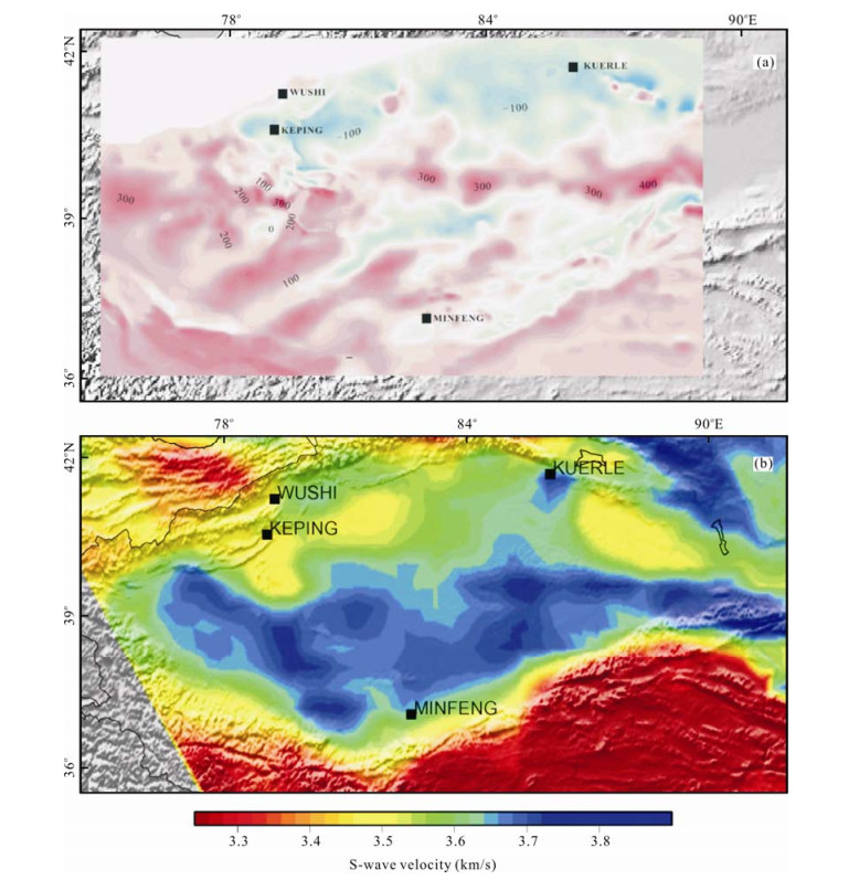
Li, H. Y., Li, S. T., Song, X. D., et al., 2012. Crustal and Uppermost Mantle Velocity Structure beneath Northwestern China from Seismic Ambient Noise Tomography. Geophysical Journal International, 188(1): 131–143, doi: 10.1111/j.1365-246X.2011.05205.x |
Li, M. J., Wang, T. G., Chen, J. F., et al., 2009. Paleo-Heat Flow Evolution of the Tabei Uplift in Tarim Basin, Northwest China. Journal of Asian Earth Sciences, 37(1): 52–66, doi: 10.1016/j.jseaes.2009.07.007 |
Li, Q. M., Cai, Z. Z., Tang, Z. J., et al., 2009. Significance of Hercynian Movement in Hydrocarbon Accumulation in Tarim Basin. Xinjiang Petroleum Geology, 30(2): 171–174 (in Chinese with English abstract) http://en.cnki.com.cn/Article_en/CJFDTOTAL-XJSD200902010.htm |
Lin, C. S., Li, S. T., Liu, J. Y., et al., 2011. Tectonic Framework and Paleogeographic Evolution of the Tarim Basin during the Paleozoic Major Evolutionary Stages. Acta Petrologica Sinica, 27(1): 210–218 (in Chinese with English Abstract) |
Lin, C. S., Yang, H. J., Liu, J. Y., et al., 2008. Paleohigh Geomorphology and Paleogeographic Framework and Their Controls on the Formation and Distribution of Stratigraphic Traps in the Tarim Basin. Oil and Gas Geology, 29(2): 189–197 (in Chinese with English Abstract) http://en.cnki.com.cn/Article_en/CJFDTOTAL-SYYT200802005.htm |
Liu, J. Y., Lin, C. S., Cai, Z. Z., et al., 2010. Palaeogeomorphology and Its Control on the Development of Sequence Stratigraphy and Depositional Systems of the Early Silurian in the Tarim Basin. Pet. Sci. , 7(3): 311–322, doi: 10.1007/s12182-010-0073-1 |
Lü, H. T., Zhang, Z. P., Shao, Z. B., et al., 2010. Structural Evolution and Exploration Significance of the Early Paleozoic Palaeo-Uplifts in Bachu-Maigaiti Area, the Tarim Basin. Oil & Gas Geology, 31(1): 76–83 (in Chinese with English Abstract) http://en.cnki.com.cn/Article_en/CJFDTOTAL-SYYT201001018.htm |
Markello, J. R., Koepnick, R. B., Waite, L. E., 2006. The Carbonate Analogs through Time (CATT) Hypothesis—A Systematic and Predictive Look at Phanerozoic Carbonate Reservoirs. 2005–2006 AAPG Distinguished Lecture, Search and Discovery Article #40221 (2006) Posted November 6, 2006 |
Pang, X. Q., Meng, Q. Y., Jiang, Z. X., et al., 2010. A Hydrocarbon Enrichment Model and Prediction of Favorable Accumulation Areas in Complicated Superimposed Basins in China. Pet. Sci. , 7: 10–19, doi: 10.1007/s12182-010-0002-3 |
Pang, X. Q., Zhou, X. Y., Jiang, Z. X., et al., 2012. Hydrocarbon Reservoirs Formation, Evolution, Prediction and Evaluation in the Superimposed Basins. Acta Geologica Sinica, 86(1): 1–103 (in Chinese with English Abstract) doi: 10.1111/j.1755-6724.2012.00606.x |
Qi, L. X., Yun, L., 2010. Development Characteristics and Main Controlling Factors of the Ordovician Carbonate Karst in Tahe Oilfield. Oil & Gas Geology, 31(1): 1–12 (in Chinese with English Abstract) http://www.researchgate.net/publication/285064925_Development_characteristics_and_main_controlling_factors_of_the_Ordovician_carbonate_karst_in_Tahe_oilfield |
Ren, J. Y., Zhang, J. X., Yang, H. Z., et al., 2011a. Analysis of Fault Systems in the Central Uplift, Tarim Basin. Acta Petrologica Sinica, 27(1): 219–248 (in Chinese with English Abstract) http://www.researchgate.net/publication/287538156_Analysis_of_fault_systems_in_the_Central_uplift_Tarim_Basin |
Ren, J. Y., Hu, D. S., Yang, H. Z., et al., 2011b. Fault System and Its Control of Carbonate Platform in Tazhong Uplift Area, Tairm Basin. Geology in China, 38(4): 935–944 (in Chinese with English Abstract) http://en.cnki.com.cn/Article_en/CJFDTOTAL-DIZI201104012.htm |
Wang, H. Z., Li, S. T., 2004. Tectonic Evolution of China and Its Control over Oil Basins. Journal of China University of Geosciences, 15(1): 1–8 |
Xiang, C. F., Pang, X. Q., Yang, W. J., et al., 2010. Hydrocarbon Migration and Accumulation along the Fault Intersection Zone—A Case Study on the Reef-Flat Systems of the No. 1 Slope Break Zone in the Tazhong Area, Tarim Basin. Pet. Sci. , 7: 211–225, doi: 10.1007/s12182-010-0021-0 |
Xiao, X. C., Liu, X., Gao, R., 2004. Geotransect of Tianshan-Tarim-Kunlunshan, Xinjiang, China. Geological Publishing House, Beijing (in Chinese) |
Xiao, X. C., Wang, J., Su, L., et al., 2005. An Early Aged Ophiolite in the Western Kunlun Mts., NW Tibet Plateau and Its Tectonic Implications. Acta Geologica Sinica, 79(6): 778–786 (in Chinese with English Abstract) doi: 10.1111/j.1755-6724.2005.tb00932.x |
Xu, Z. Q., Li, H. B., Yang, J. S., 2006. An Orogenic Plateau-The Orogenic Collage and Orogenic Types of the Qinghai-Tibet Plateau. Earth Science Frontiers, 13(4): 1–17 (in Chinese with English Abstract) http://www.researchgate.net/publication/284762628_An_orogenic_plateau_The_orogenic_collage_and_orogenic_types_of_the_Qinghai-Tibet_Plateau |
Xu, Z. Q., Li, S. T., Zhang, J. X., et al., 2011a. Paleo-Asia and Tethyan Tectonic Systems with Docking the Tarim Block. Acta Petrologica Sinica, 27(1): 1–22 (in Chinese with English Abstract) http://en.cnki.com.cn/Article_en/CJFDTOTAL-YSXB201101002.htm |
Xu, Z. Q., Yang, J. S., Li, H. B., et al., 2011b. On the Tectonics of the India-Asia Collision. Acta Geologica Sinica, 85(1): 1–33 (in Chinese with English Abstract) doi: 10.1111/j.1755-6724.2011.00375.x |
Yang, J. S., Xu, X. Z., Li, T. F., et al., 2011. U-Pb Ages of Zircons from Ophiolite and Related Rocks in the Kumishi Region at the Southern Margin of Middle Tianshan, Xinjiang: Evidence of Early Paleozoic Oceanic Basin. Acta Petrologica Sinica, 27(1): 77–95 (in Chinese with English Abstract) |
Yang, W. C., 2009. Tectonophysics of Paleo-Tethyan. Petroleum Industry Press, Beijing. 443 (in Chinese) |
Yu, X., Huang, T. Z., Tang, L. J., et al., 2011. Salt-Related Faults in the Tazhong Uplift, Tarim Basin. Acta Geologica Sinica, 85(2): 179–184 (in Chinese with English Abstract) http://en.cnki.com.cn/Article_en/ http://search.cnki.net/down/default.aspx?filename=DZXE201102004&dbcode=CJFD&year=2011&dflag=pdfdown |
Yuan, X. C., 1996. Geophysical Atlas of China. Geological Publishing House, Beijing (in Chinese) |
Yun, L., Zhai, X. X., 2008. Discussion on Characteristics of the Cambrian Reservoirs and Hydrocarbon Accumulation on Well Tashen-1, Tarim Basin. Oil & Gas Geology, 29(6): 726–732 (in Chinese with English Abstract) http://www.cnki.com.cn/Article/CJFDTotal-SYYT200806006.htm |
Zhai, X. X., Yun, L., 2008. Geology of Giant Tahe Oilfield and a Review of Exploration Thinking in the Tarim Basin. Oil & Gas Geology, 29(5): 565–573 (in Chinese with English Abstract) http://en.cnki.com.cn/Article_en/CJFDTOTAL-SYYT200805008.htm |
Zhang, G. Y., Zhao, W. Z., Wang, H. J., et al., 2007. Multicycle Tectonic Evolution and Composite Petroleum System in the Tarim Basin. Oil & Gas Geology, 28(5): 653–663 (in Chinese with English Abstract) http://www.cqvip.com/Main/Detail.aspx?id=25713974 |
Zhang, L. J., Li, Y., Zhou, C. G., et al., 2007. Lithofacies Paleogeographical Characteristics and Reef-Shoal Distribution during the Ordovician in the Tarim Basin. Oil & Gas Geology, 28(6): 731–737 (in Chinese with English Abstract) http://en.cnki.com.cn/Article_en/CJFDTOTAL-SYYT200706006.htm |
Zhang, S. C., Zhang, B. M., Li, B. L., et al., 2011. History of Hydrocarbon Accumulations Spanning Important Tectonic Phases in Marine Sedimentary Basins of China: Taking the Tarim Basin as an Example. Petroleum Exploration and Development, 38(1): 1–15 doi: 10.1016/S1876-3804(11)60010-4 |
Zhao, J. M., 2003. Lithospheric Structure and Dynamic Processes of the Tianshan Orogenic Belt and the Jungger Basin. Tectonophysics, 376: 199–239 doi: 10.1016/j.tecto.2003.07.001 |
Zhao, J. M., Moocy, W. D., Zhang, X. K., et al., 2006. Crustal Structure across the Altyn Tagh Range at the Northern Margin of the Tibetan Plateau and Tectonic Implications. Earth and Planetary Science Letters, 241(3–4): 804–814, doi: 10.1016/j.epsl.2005.11.003 |
Zhao, Z. J., Wu, X. N., Pan, W. Q., et al., 2009. Sequence Lithofacies Paleogeography of Ordovician in Tarim Basin. Acta Sedimentologica Sinica, 27(5): 939–955 (in Chinese with English Abstract) http://www.researchgate.net/publication/287492086_Sequence_lithofacies_paleogeography_of_Ordovician_in_Tarim_Basin |
Zhao, Z. Z., Du, J. H., Zou, C. N., et al., 2011. Geological Exploration Theory for Large Oil and Gas Provinces and Its Significance. Petroleum Exploration and Development, 38(5): 513–522 doi: 10.1016/S1876-3804(11)60051-7 |
Zhou, X. Y., Pang, X. Q., Li, Q. M., et al., 2010. Advances and Problems in Hydrocarbon Exploration in the Tazhong Area, Tarim Basin. Pet. Sci. , (7): 164–178, doi: 10.1007/s12182-010-0020-1 |