Advanced Search

Indexed by SCI、CA、РЖ、PA、CSA、ZR、etc .

2012 Vol. 23, No. 4

Display Method:
Research
Dynamic Processes of the Paleozoic Tarim Basin and Its Significance for Hydrocarbon Accumulation—A Review and Discussion
Sitian Li, Jianye Ren, Fengcun Xing, Zhanhong Liu, Hongyi Li, Qianglu Chen, Zhen Li
2012, 23(4): 381-394. doi: 10.1007/s12583-012-0262-5
Abstract:
The structural framework and evolution processes of the giant superimposed Tarim basin in Paleozoic Era are controlled by three main factors: (1) features and structures of the basin basement; (2) deep mantle dynamics process (such as the Sinian rifting and the Permian plume-related magmatic activities); (3) the powerful regional compressional or compresso-shear stress regime generated by the orogenic movement from surrounding regions. The latter of which occurring in multiple episodes is the most important factor for the Paleozoic Tarim basin evolution. Under the above tectonic background, the underlying lithosphere of the Tarim basin had been flexed, and then the upper crust was folded. The paleo-uplifts (e.g., Tabei (塔北) and Tazhong (塔中)) and depressions occurred in both of the flexural and folding processes, which are different with the models of foreland basin in stable and large cratons in the world. During the early evolution stage in Cambrian-Early Ordovician, low-relief paleo-uplifts, and open carbonate platforms formed in center area, while during the Late Ordovician compressional tectonic regime, the belted uplifts and restricted platforms formed in the contemporaneous folding processes. Denudated stages occurred during the strong tectonic events marked by the unconformities and karstified weathered crusts formed on platforms. All the discovered giant-middle oilfields are closely related to the paleo-uplift and karstified crust evolution. There are two main types of oil reservoir: paleo-karst type and reef-bank type on the carbonate platform in paleo-uplift areas. In Permian, plume-related massive magmatic activities led to geo-temperature increase and the regional uplifting in this basin, ending the marine deposit filling sequences and starting the formation of terrestrial deposits-dominated sequences. With abundant supply from giant hydrocarbon generation depressions, the most important oil fields formed in Tabei and Tazhong areas. To reveal the multi-stage evolution processes and the structural framework of the paleo-uplifts may be helpful for the prediction of new hydrocarbon domains. The integrated study on coupling relationship between the basin and surrounding orogens can provide an important approach for the superimposed basin dynamic research.
Major Unconformities, Tectonostratigraphic Frameword, and Evolution of the Superimposed Tarim Basin, Northwest China
Changsong Lin, Hao Li, Jingyan Liu
2012, 23(4): 395-407. doi: 10.1007/s12583-012-0263-4
Abstract:
The Tarim basin experienced a complex tectonic evolutionary history from Sinian to Cenozoic. Eight large-scale and more than 20 subordinate unconformities defining tectonosequences of different protobasins formed in various tectonic settings have been identified within the Phanerozoic in the Tarim basin, their distribution determining the general characteristics of sequence stratigraphic framework of the basin. Tectonostratigraphic unit Ⅰ (magasequence) consists mainly of the Sinian System, which formed in a rift or aulacogen setting and can been subdivided into two subordinate stratigraphic units (supersequences). Unconformity (Tg9) between Sinian and Cambrian with surface karstification is regarded as a post-rift unconformity. Tectonostratigraphic unit Ⅱ comprises the Cambrian and the Ordovician and can be divided into six subordinate tectonostratigraphic units, recording the tectonogeographic evolution of the prototype basins from Cambrian to Early Ordovician passive carbonate continental margin or cratonic depression and the Late Ordovician submarine to neritic retroarc foreland and cratonic depressions. The tectonic uplift related to the formation of the unconformity Tg5-2 resulted in the remarkable change in basin tectonic setting from a passive divergent to an active convergent, with the development of the Tazhong (塔中) uplift, the Tangguzibasi (塘古孜巴斯), and the northern depression at the end of the Middle to the early Late Ordovician. The widespread angular unconformity Tg5 formed by a relatively strong compressive deformation, which caused an abrupt tectonogeographic change of the basin from abyssal to a neritic setting in response to the collision and associated tectonic deformation of the North Kunlun (昆仑) orogenesis during the Late Ordovician to the Early Silurian. Tectonostratigraphic unit Ⅲ is composed of the Silurian and the Lower to Middle Devonian and characterized by the development of fluvial or deltaic and clastic littoral and neritic deposits. Large-scale terrigenous clastic depositional wedges progradated from the north to south in the southeastern slope of the basin indicate the continuously shallowing and uplifting along the northern basin margin. Tectonostratigraphic unit Ⅳ includes the Upper Devonian, Carboniferous, and Permian and can be classified into two subordinate tectonostratigraphic sequences. The angular unconformity (Tg3) at the base of the unit is the most widespread unconformity and the strong compression and uplift of the basin during this period has been suggested to be related to the collision of the Tianshan (天山) orogenesis and resulted in fundamental change in tectonic geomorphology with higher to the northeast and lower to the southwest. Tectonostratigraphic unit Ⅳ records another tectonic cycle from weak extension to compression in basin setting and is composed mainly of nearshore clastic deposits of embayment basin fills. From the Triassic, the Tarim basin evolved into a period characteristic of development of intracontinental depressions and marginal foreland basins and experienced several cycles from rapid subsidence to strong uplift and deformation, resulting in superimposition and reformation of differently orientated protobasins filled with a series of regional depositional cycles bounded by major unconformities and consisting of extremely thick alluvial and lacustrine deposits. The Kuqa foreland depression in the northwestern basin margin developed since the Triassic and deposited a clastic wedge of the Mesozoic to Cenozoic more than 100 000 m in thickness, which progradated and thin towards the southern Tabei (塔北) forebulge. The large-scale sedimentary cycles from alluvial, fluvial to lacustrine, and finally fluvial deposits are attributed to the results of foreland tectonisim from active to relatively quiet stages. The foreland tectonisim was active during the Triassic, relatively quiet during the Jurassic, and active again from the Late Jurassic to the Cretaceous. To the Eogene, the depression subsided again and the compression intermittently increased, resulting in a series of faulted and folded structural belts.
Paleoecology of the Ordovician Reef-Shoal Depositional System in the Yijianfang Outcrop of the Bachu Area, West Tarim Basin
Yangquan Jiao, Liqun Wu, Hui Rong, Yongbiao Wang, Rui Wang
2012, 23(4): 408-420. doi: 10.1007/s12583-012-0264-3
Abstract:
The reef-shoal depositional system of the Ordovician carbonate platform margin is well exposed in the Yijianfang (一间房) outcrop of the Bachu (巴楚) uplift region, which offers an advantageous condition to study their paleoecology. Using a detailed field geologic survey and illustrated profiles of typical depositional systems, three types of genetic facies associations can be recognized in the reef-shoal depositional system: an organic reef, an organic shoal, and an upper slope. The organic reef is composed of three types of genetic facies (a reef base, a reef core, and fore-reef breccias); the organic shoal is formed from five types of genetic facies (tide channels, fore-reef inner shoals, fore-reef outer shoals, back-reef inner shoals, and back-reef outer shoals). The studies of the paleontological assemblage in each genetic facies of the depositional system indicate that the fauna preserved in each genetic facies are varied. The calathium, archaeoscyphia, bryozoan, and calcareous alga are well preserved in the organic reefs. The organisms preserved in the organic shoals are generally fragmented, while well-preserved girvanella and nuia siberica with a content of about 15% in the back-reef outer shoals are the most characteristic and different from others. The sinoceras, trilobites, and gastropods are well preserved in the upper slope deposits. The studies will demonstrate that the reef-shoal complexes developed above the base of the fair-weather wave base and that the original hydrodynamic conditions for the reef core forming is the stronger and become more and more low-energy from the inner part to outer part of the organic shoals.
Seismic Reflection, Distribution, and Potential Trap of Permian Volcanic Rocks in the Tahe Field
Renhai Pu, Yunlong Zhang, Jinglan Luo
2012, 23(4): 421-430. doi: 10.1007/s12583-012-0265-2
Abstract:
Permian Kaipaileicike (开派雷兹克) volcanic rocks approximately 0–200 m thick are drilled in the Tahe (塔河) field. The distribution of volcanic rocks and their potential to form hydrocarbon reservoirs are discussed based on the integrated interpretation of log and 3D seismic data. The volcanic rocks, mainly consisting of dacites and basalts, are sandwiched between the Lower Triassic and Lower Carboniferous and bounded by top and bottom unconformities. The dacites accumulated in a mound shape around volcanic craters, whereas the basalts are deposited in tabular or trough-fill geometries. Permian volcanic craters mainly located at the northwest corner of the Tahe field are identified from volcanic rock thickening, occurrence of volcanic breccias, structural arch of the top Permian, seismic attribute anomalies, and fault (piercing conduit) reflections. Along the northwest wing of a Carboniferous salt dome, a stratigraphic trap is formed by a northeast updip pinch-out of Permian volcanic rock. Oil indications within the trap are found in numerous wells. The reservoir volcanic rocks are mainly of the fracture-pore pattern and covered by the caprock of a Lower Triassic mudstone. The hydrocarbon reservoir, which can potentially be a medium-sized oil pool, is connected to Cambrian-Ordovician source rocks through normal faults along the salt dome boundary.
Platform Edge Reef and Bank Structure and Depositional Model of Changxing Formation in Panlongdong Section, Xuanhan, Northeastern Sichuan
Mingyi Hu, Zhonggui Hu, Xiaosong Qiu, Enzhang Zhao, Dan Wang
2012, 23(4): 431-441. doi: 10.1007/s12583-012-0266-1
Abstract:
The Changxing (长兴) Formation has two sequences (sq1 and sq2) in the Panlongdong (盘龙洞) Section, Xuanhan (宣汉), northeastern Sichuan (四川). It belongs to the platform edge facies belt, rich in reefs and banks, which were developed in the highstand system tract (HST) of sq1 and sq2, respectively. During third-order relative sea level dropping, the platform edge reef bank were mainly developed in the overall progradation parasequence sets. The platform edge reefs were developed in three phases, while platform edge banks in two phases. Outcrop observation and microscopic identification for platform egde reefs and banks in the section show that the three-phase-reefs are all composed of reef base and reef core, with string of tube sponge as the major reef-building organisms and fiber sponge, hydrazoan and bryozoans as the minor, while the reef-attached organisms mainly being foraminifera, brachiopod, echinoderm and ostracod. The first-phase-reef rock type is baffling reefs, the second phase baffling reefs and framework reefs assembles, the third phase framework reefs. Typically, the second phase reefs were developed with the maximum sedimentary scale and thickness, with the most abundant reef-building organisms and reef-attached organisms, showing best physical properties for reservoirs. The platform edge banks mainly consists of gravel debris and ooide grains, mostly dolomized. The dolomitizition in the second phase was relatively intense, favoring good reservoirs.
Geochemical Characteristics and Petrogenesis of Permian Basaltic Rocks in Keping Area, Western Tarim Basin: A Record of Plume-Lithosphere Interaction
Junchuan Yu, Xuanxue Mo, Xuehui Yu, Guochen Dong, Qiang Fu, Fengcun Xing
2012, 23(4): 442-454. doi: 10.1007/s12583-012-0267-0
Abstract:
The two basalt flows in Kupukuziman (库普库兹满) Formation of Keping (柯坪) area are the typical products of Permian magmatism. Based on systematic field investigations, we carried out geochemical studies on representative Keping basalts. The results show that the SiO2 contents in basalts range from 44.69 wt.% to 51.68 wt.%, and the total alkalis range from 4.05 wt.% to 5.5 wt.%, belonging belonging to alkaline basalts. The Ti/Y=468.27–565.35 and TiO2=(2.88–3.82) wt.% compared to those of the high-Ti basalts in Emeishan (峨眉山) large igneous province (LIP) (TiO2=(3.58–5.21) wt.%, Ti/Y > 500, Xiao et al., 2004). The contents of MgO and compatible elements Cr (12.9–18.6 ppm), Ni (13.7–22.7 ppm), and Co (39.6–50.2 ppm) are low, which suggest that the samples have undergone varying grades of fractional crystallization. All the samples have uniform REE and other trace element characteristics, with enriched LREE and LILE relative to HREE and HFS, similar REE patterns without Eu anomaly. The basalts are also show slightly depleted of Ta and Nb. They have higher initial87Sr/86Sr ratios (0.707 211–0.708 300), lower ɛNd(t) values (−2.47 to −4.14), and a narrow range of (208Pb/204Pb)t=37.535 2–38.297 7, (207Pb/204Pb)t=15.435 7–15.517 0, and (206Pb/204Pb)t=17.206 5–17.874 7 ratios. The Ce/Y versus Zr/Nb diagram shows that the parent magmas were originated from low-degree partial melting of the garnet-lherzolite. The analysis results based on geochemical studies seem all point to the same conclusion that the Keping basalts have formed as a product of the interaction between the plume-derived melts and the lithosphere.
Detrital zircon U-Pb geochronology and its provenance implications on Silurian Tarim basin
Jingyan LIU, Changsong LIN, Sitian LI, Zhenzhong CAI, Shiqiang XIA, Chao FU, Yongquan LIU
2012, 23(4): 455-475. doi: 10.1007/s12583-012-0268-z
Abstract:
As one of the major exploration objects of marine deposit in Tarim basin, Silurian has been paid more attention from oil/gas exploration and geologists. However, due to the widely deposit and later erosion, it is difficult to restore the original basin. The surrounding tectonic activity and provenance systems of Silurian Tarim basin have a lot of controversy. Aid of detrital zircons U-Pb dating data obtained from well drilling of Tabei (塔北) and Tazhong (塔中) areas and Sishichang (四十场) and Xiangyangcun (向阳村) outcrop profiles, integrated with other geological and geophysical data, the tectothermal evolution and provenance nature of Silurian deposit have been revealed. Zircons U-Pb dating shows Tarim basin has experienced 5–6 significant tectothermal events: 3 500–3 000 Ma Paleo-Mesoarchean, around 2 500 and 1 800 Ma Paleoproterozoic, around 1 000 and 800 Ma Neoproterozoic, and 500–400 Ma Eopaleozoic tectothermal events. These tectothermal events reflected the evolution of Tarim microplates and Tarim basin, respectively, corresponded to the forming and spilitting process of Ur supercontinent, Kenorland, Columbia and Rodinia supercontinent. Difference between the samples of Tazhong and Tabei areas indicated that North and South Tarim microplates were different in Paleo-Mesoarchean, and later evolutions were more synchronous after Paleoproterozoic. Integrated with seismic data and outcrop interpretation, the U-Pb dating results also revealed that the surrounding tectonic activities were still very active during Silurian, and indicated different regions had different source systems. At Tadong (塔东) and Manjiaer (满加尔) depressions, major source systems came from Ordovician Altyn orogenic belts. At Tabei area and northwest of Tarim basin, major source systems came from recycling orogenic zone (the activity of South Tianshan (天山) Mountain) and Precambrian stable basement (local paleo-uplifts at north of Tabei). The Ordovician uplift and orogenic zone at the south of Tarim basin and Precambrian granite basement provided lots of source systems to Tazhong area.
Genesis and environment characteristics of dolomite-hosted quartz and its significance for hydrocarbon exploration, in Keping Area, Tarim Basin, China
Fengcun XING, Sitian LI
2012, 23(4): 476-489. doi: 10.1007/s12583-012-0269-y
Abstract:
A great amount of quartz was found filling vugs of the dolomite strata of Upper Cambrian-Lower Ordovician in Keping (柯坪) outcrop area of Tarim basin, China, which is widely distributed with obvious impact on dolomite reservoirs. The quartz's genesis and environment were studied based on careful field observation and indoor comprehensive analysis. The abnormal high temperature of the primary saline aqueous inclusions of quartz minerals might reach as high as 578 ℃, showing the characteristics of basin abnormal heat events. The quartz-rare earth element (REE) pattern is similar to those of the granite, diabase, and basalt of Permian in Tabei (塔北) area. According to the regional geological setting and quartz's distribution as well as its occurrence, the genesis of quartz is attributed to Permian magmatic activity-related hydrothermal liquid instead of the primary marine sedimentary genesis or regional metamorphic genesis. The δ13C values of CO2 in the quartz inclusions range from −1.4‰ to −4.6‰, which might derive from the mantle, while δ18O of SiO2 indicates a hot fluid genesis of meteoric precipitation, which consists of the meteoric precipitation diagenetic setting of C and O isotopes in the dolomite host rocks and the low-medium salinity freshwater condition in the inclusions. REEs must have experienced clear differentiation, since the values of LREE/HREE are all over 1, clearly indicating the characteristic of enrichment of LREE and decrement of HREE. Ce has no obvious anomaly and Eu has clear negative anomalies, which suggests a reducing environment when the quartz crystallized. After the comprehensive analysis, we believe that quartz is a product of siliceous hydrothermal liquids in combination with meteoric precipitation under a reducing environment. Additionally, the precipitation hydrothermal fluid mixture might have also mixed thoroughly with the formation water and exchanged material with the host dolomites. The significance of siliceous hydrothermal fluids for dolomite reservoirs as well as oil-gas exploration is finally discussed in this article.
Reef types and sedimentation characteristics of Changxing formation in Manyue-Honghua Section of Kaixian, Northeastern Sichuan Basin
Liqun WU, Yangquan JIAO, Hui RONG, Rui WANG, Rong LI
2012, 23(4): 490-505. doi: 10.1007/s12583-012-0270-5
Abstract:
In Changxing (长兴) stage,Manyue (满月)-Honghua (红花) Section of Kaixian (开县),northeastern Sichuan (四川) Province was located in the platform-margin slope,which was the advantage area of reef-shoal depositional system developing. The strata of Changxing Formation are continuously exposed on both Honghua Section and Manyue Section. Four and two depositional cycles can be identified in Honghua Section and Manyue Section,respectively. They are all platform-margin reef-shoal deposits. Their lithologic associations have obvious sequence,which is as follows: micrite bioclast limestone,bafflestone,bindstone,framestone,and bioclast limestone,in order from below. The paleontological assemblages are controlled by water depth and genetic facies. Six paleontological assemblages can be identified in Honghua Section and Manyue Section; they are coral-calcareous algae-calcareous sponge assemblage,calcareous sponge-calcareous algae assemblage,calcareous sponge-calcareous algae-coral-bryozoan assemblage,calcareous sponge-calcareous algae-hydra assemblage,calcareous sponge-calcareous algae-hydra-bryozoan assemblage,and calcareous sponge-calcareous algae-hydra-bryozoan-coral assemblage. The study of lithologic associations and paleontological assemblages indicates that the water body shallowed upward in both the growth cycle of a single reef and the higher-grade depositional cycle. According to the water depth types of reef (bioherm) developing,three different reef-shoal depositional systems can be identified in study area: deep-water-type bioherm,transitional-type reef (bioherm),and more shallow-water-type reef.
Features and controlling factors of epigenic karstification of the Ordovician carbonates in Akekule arch, Tarim Basin
Qianglu CHEN, Yongqiang ZHAO, Guorong LI, Chenglin CHU, Bin WANG
2012, 23(4): 506-515. doi: 10.1007/s12583-012-0271-4
Abstract:
Tabei (塔北) uplift is an area with the highest hydrocarbon enrichment in Tarim basin,and large oilfields have been found on Akekule (阿克库勒) arch at the middle section of Tabei uplift,with Ordovician carbonate reservoirs. Storage space of the Ordovician carbonate reservoirs in the Akekule arch are mainly caves,pores and fractures resulted from dissolution and/or karstification. The Ordovician carbonate reservoirs are affected and modified by the diagenetic process in penecontemporaneous,epigenetic and burial periods and the multi-stage karstification related with deep hydrothermal activities,among which the most significant effect is from the meteoric water karstification related to the tectonic uplift from the end of Middle Ordovician to the end of Late Ordovician (end of O2-end of O3) and at the end of Middle Devonian (end of D2). Varied palaeogeologic settings and tectonic features at different geologic periods lead to different fluid flowing patterns,karstification mechanisms and transformation features in different regions,which further influence the reservoir distribution. The paleo-uplifts at different periods,such as end of O2-end of O3 and end of D2,control the dominant development zones of karstification; the paleogeomorphology and faults resulted from tectonic uplift control the flowing depth of the karst fluid; and the lithology controls the position and extent of karst development.
Orbital cycles analysis and its genesis significance for the sequence hierarchy: A case study of Carboniferous Karashayi Formation, Central Tarim basin
Zhanhong LIU
2012, 23(4): 516-528. doi: 10.1007/s12583-012-0272-3
Abstract:
The Carboniferous Karashayi (卡拉沙依) Formation of Tarim basin formed in the epicontinental sea shelf environment where the evolution of basins is pediocratic. As an important reservoir-forming combination, the Carboniferous Karashayi Formation consist of clastic rocks, carbonate rocks and gypsum rocks, which show clear sedimentary cyclicity. According to paleontology research and stratigraphic correlation, Karashayi Formation corresponds to Visean and Serpukhovian in international stratigraphic chart with a time limit about ±27 Ma. The sequence stratigraphic study for the Karashayi Formation is rough because of the difficulty to identify the unconformity surfaces. The current study mostly divides it into three or four 3rd sequences. However, this partition cannot meet the geological crossing correlation. At the theory aspect of sequence stratigraphy, the genesis of the 3rd sequence is also a disputed problem. Cyclostratigraphy study of the Natural Gamma-Ray Log, Spontaneous Potential Log and other logging curves has been taken out by spectrum analysis and wavelet analysis, etc.. For Well Shun6 and Well Zhong1 in Tazhong (塔中) and neighbouring area, combined core observation and base level analysis, the Karashayi Formation was divided into 9 or 11 sequence stratigraphic units. Continuous constraints of each sequence is about ±2.40 Ma, corresponding to astronomical cycle formed by three parameters of Earth orbit. Accompanied by the historical division of 3rd sequences, the formation mechanism of 3rd sequences was possibly forced by the 2.4 Ma astro-nomical eccentricity cycles.
Fault system, deformation style and development mechanism of the Bachu uplift, Tarim basin
Dianjun TONG, Junxia ZHANG, Huaizhong YANG, Desheng HU, Jianye REN
2012, 23(4): 529-541. doi: 10.1007/s12583-012-0273-2
Abstract:
The Bachu (巴楚) uplift is one of the most active tectonic regions nowadays in the Tarim basin, which is also a faulted block uplift that was intensively active during the Cenozoic. This study was based primarily on the geological structure interpretation of seismic profiles, applying the theories and methods of basin dynamics, structural analysis and tectono-stratigraphic analysis, the geometry and kinematics features of the fault systems in the Bachu uplift were analyzed in detail. Our study shows that each fault belt is mainly characterized by compression and overthrusting, most of the faults initiated and activated during the Mid-Late Himalayan period, and that the general structural styles of the Bachu uplift were basement-involved pop-up thrust faulted block uplift, of which the southern margin was covered by the large-scale decollement fault system. The basement-involved structures widely developed in the higher position of the basement uplift, while decollement fault system developed mainly at the position with gypsum mudstone. The evolution process of Bachu uplift included back-bulge slope of the peripheral foreland basin in Mid-Late Caledonian, forebulge in Hercynian-Yanshanian and the latest compressional faulted block uplift in Mid-Late Himalayan. Meanwhile, the study also suggests that the formation, reconstruction and stabilization of the uplift were controlled by the development and evolution of fault systems clearly. In the early forebulge stage, it was mainly presented as flexural deformation without the developing of thrust faults in the Bachu area; to the late stage, under the influence of violent lateral compression deformation, the faulted block uplift formed finally.
Effects of Diagenesis on the Acoustic Velocity of the Triassic Oolitic Shoals in the Yudongzi Outcrop of Erlangmiao Area, Northwest Sichuan Basin
Hui Rong, Yangquan Jiao, Liqun Wu, Yuan Gu, Liya Zhang, Rong Li, Fanping Zeng
2012, 23(4): 542-558. doi: 10.1007/s12583-012-0274-1
Abstract:
The oolitic shoals of the Triassic carbonate platform margin in the Yudongzi (鱼洞子) outcrop of Erlangmiao (二郎庙) area in the northwestern Sichuan (四川) basin present a scarce opportunity to quantitatively describe their diagenesis and its effects on the acoustic velocity. Using a detailed field geologic survey,profiles illustration of typical depositional system,and systematic testing,five types of diagenesis have been identified in the oolitic shoals: micritization,cementation,compaction and pressolution,dissolution,and dolomitisation. The cementation is composed of four subtypes (micrite cements,fibrous calcite cements,granular calcite cements,and blocky calcite cements). The dissolution is formed from three subtypes (freshwater selective dissolution,burial non-selective dissolution,and burial selective dissolution). The dolomitisation is composed of three subtypes (fine-crystalline dolomites,microcrystalline dolomites,and medium-crystalline dolomites). In order to quantitatively describe the diagenetic fabric of oolitic shoals,the micritic grain content,calcite cement content,mean pore diameter,pore types,dolomite content,and dolomite types have been evaluated. Based on these data,the relationship between the acoustic velocity and diagenesis of oolitic shoals has been established. The results show that the diagenetic fabric is linearly related with the acoustic velocity,and the general trend observed is as expected a decrease of velocity as the micritic grain content,mean pore diameter and dolomite content increase,or the sparite cement content decreases. This study will demonstrate that the transformation of diagenetic facies will probably make the petrophysical properties of the oolitic shoals regularly changed. The reflection configuration of diagenetic facies in the oolitic shoals can be shown in the synthetic seismic model simulated according to the P-wave impedance and S-wave impedance.
Temporal and Spatial Evolution Analysis: The Early Paleozoic Paleo-Uplifts in the Tarim Basin
Hao Liu, Changsong Lin, Yingmin Wang, Dishuo Zhang
2012, 23(4): 559-581. doi: 10.1007/s12583-012-0275-0
Abstract:
Twenty unconformities,primarily superimposed types,were identified based on interpretation of a 46 000 km seismic profile combined with data from over 40 drilling wells. These respectively correspond to the main tectonic evolution stages and the boundaries between those stages. Reconstruction of the original depths of eroded strata was conducted for the Middle Caledonian,Early Hercynian,Late Hercynian,Indosinian,Early Yanshanian and Late Yanshanian unconformities using the virtual extrapolation of seismic reflection. Eroded strata thicknesses were also calculated for individual periods and intervals. Based on the reconstructed data,in combination with data from research on sedimentary facies,a paleogeomorphological profile was constructed for different tectonic evolution stages of the basin during the Early Paleozoic. The profile indicates the presence of obvious regularity in the temporal and spatial evolution of these unconformities. Based on the characteristics of paleo-uplift evolution and post-layering reconstruction,the paleo-uplifts were divided into inherited (e.g.,Tazhong (塔中)),residual (e.g.,North Tarim) and active (e.g.,Southwest Tarim and Bachu (巴楚)) types. The huge North Tarim uplift represents a typical form of residual paleo-uplift. The Paleozoic strata in the upper layers of the uplift is in poor condition for reservoir accumulation and preservation; however,the Upper Mesozoic-Cenozoic structural layer can form a secondary reservoir that is relatively rich in oil and gas. Furthermore,the flank slope area of the uplift is always a key source for oil and gas collection and the most advantageous position for the formation of the original reservoir. The Tazhong paleo-uplift has been stable since its formation in the Late Ordovician,where petroleum accumulation has been distributed not only in the uplift,but also in the deep and slope belts of the uplift. Important breakthroughs in petroleum exploration of the slope break in the North Tazhong area dating back to the Paleozoic have further confirmed the enrichment of oil and gas in this type of uplift. The Southwest Tarim paleo-uplift is a buried type,which has given it favorable properties for hydrocarbon migration over a long time. An open question is whether the large amount of oil and gas accumulated here was transported to the current Bachu uplift.
Discovery of Yanting-Tongnan Trough of Late Permian in Sichuan Basin and Its Significance
Qiufen Li, Zecheng Wang, Jun Li, Qingchun Jiang, Tongshan Wang, Jifeng Yin, Fen Xie, Shunde Miao
2012, 23(4): 582-596. doi: 10.1007/s12583-012-0276-z
Abstract:
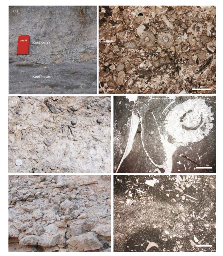
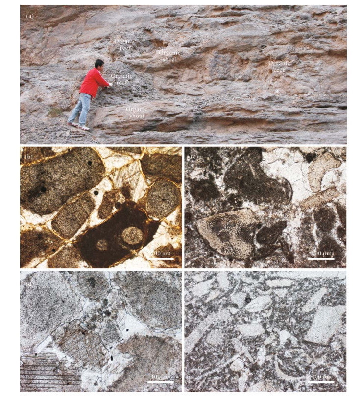
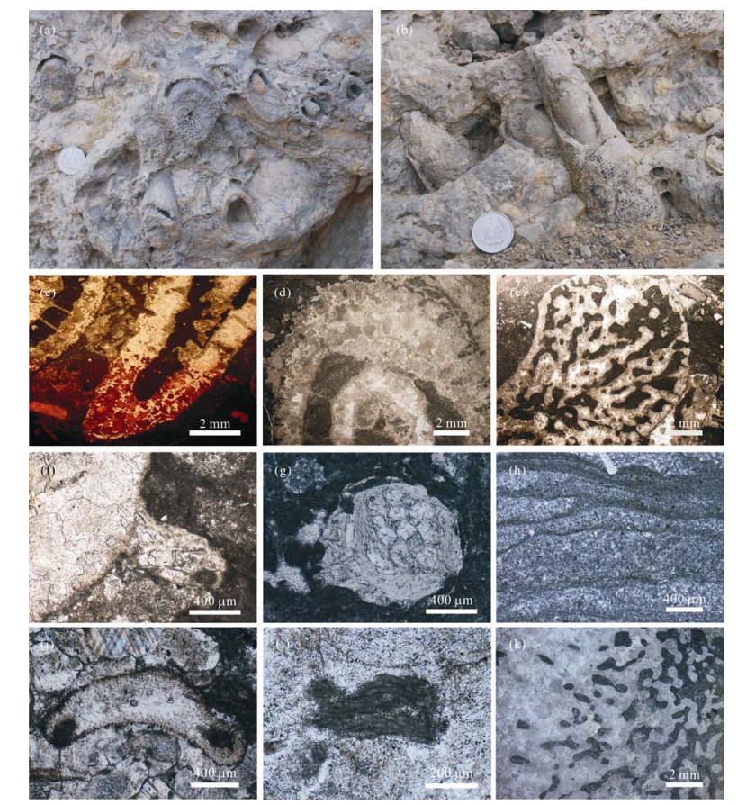
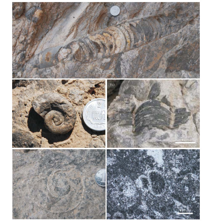
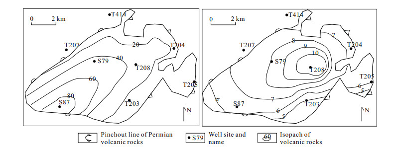
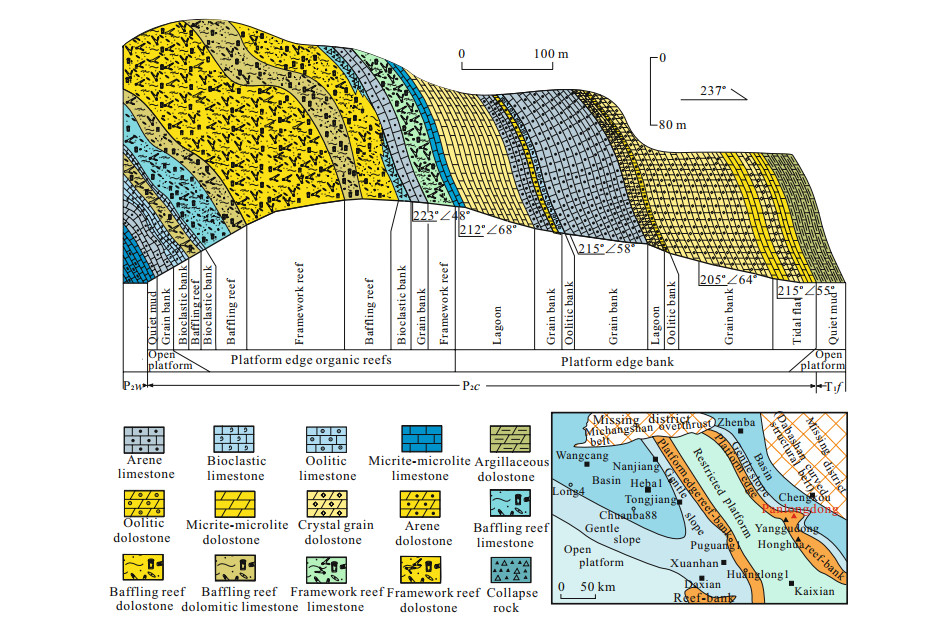
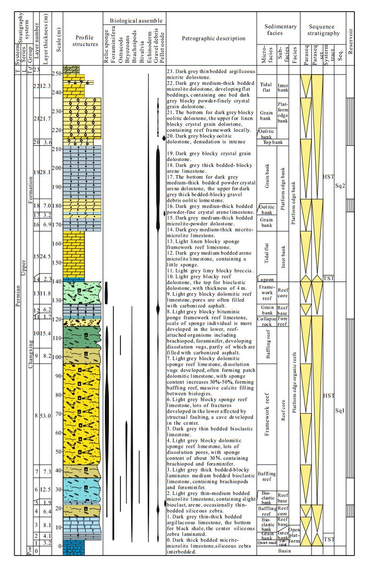
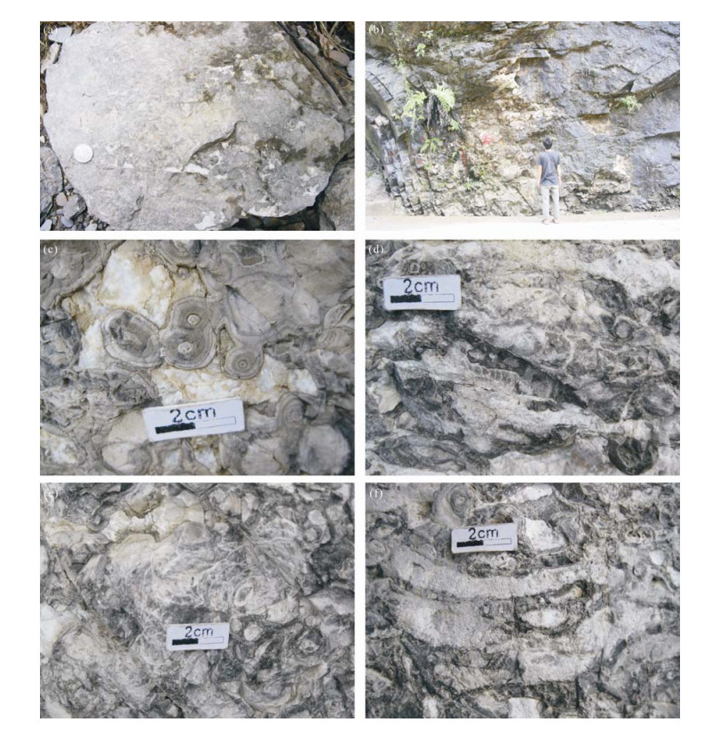
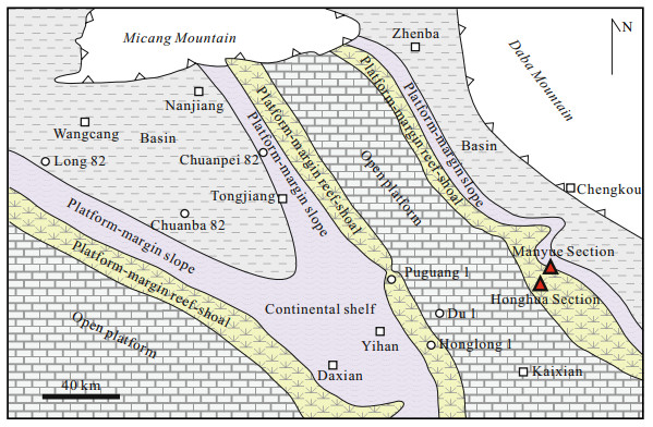
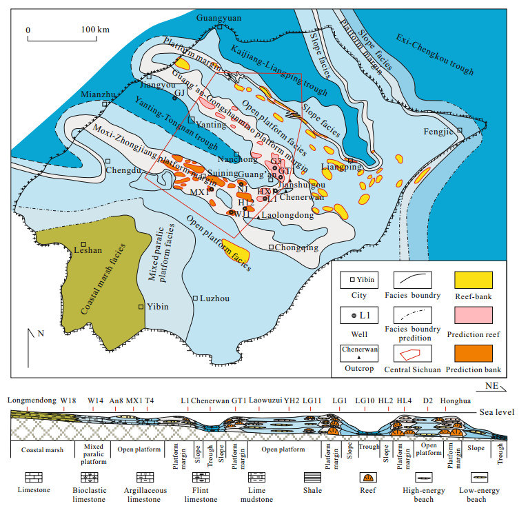
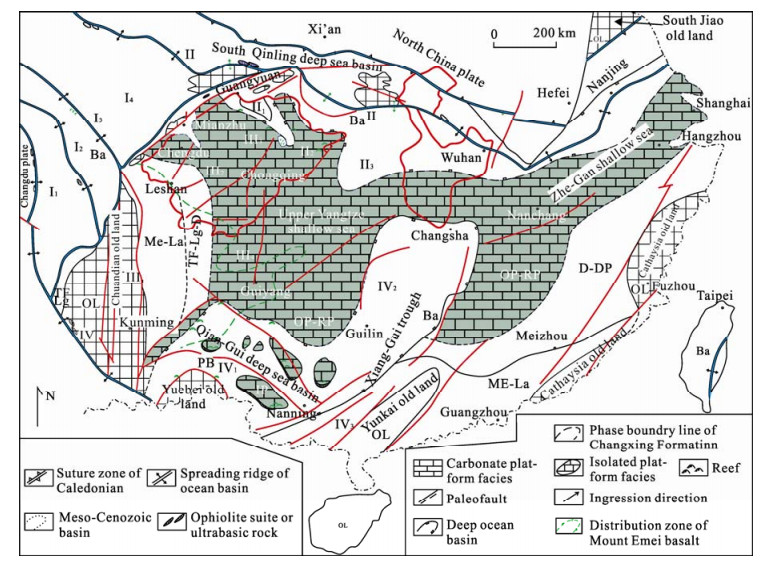
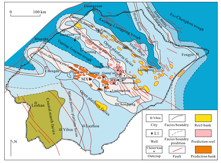
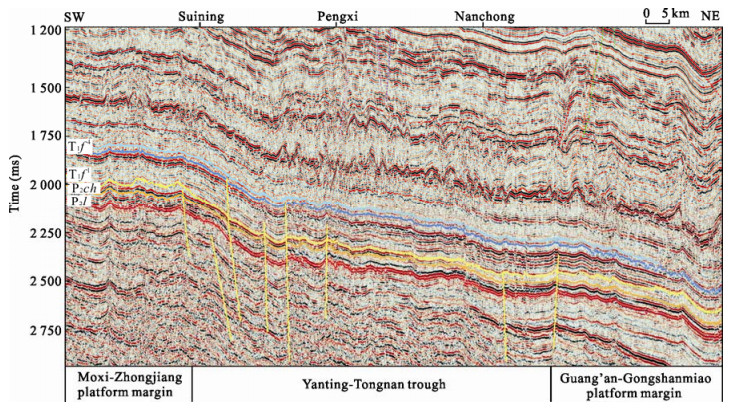
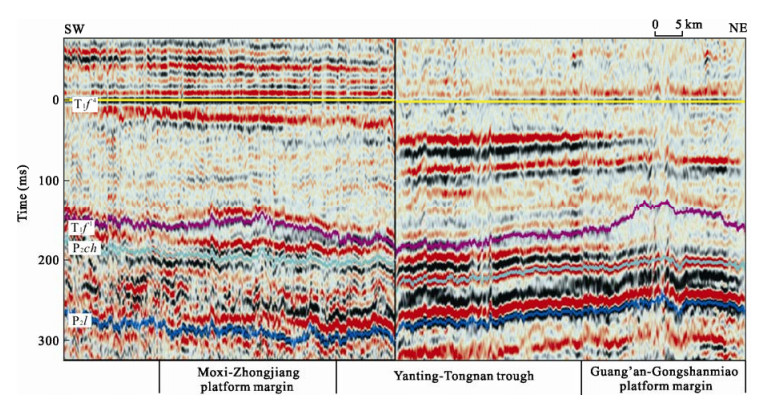
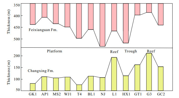
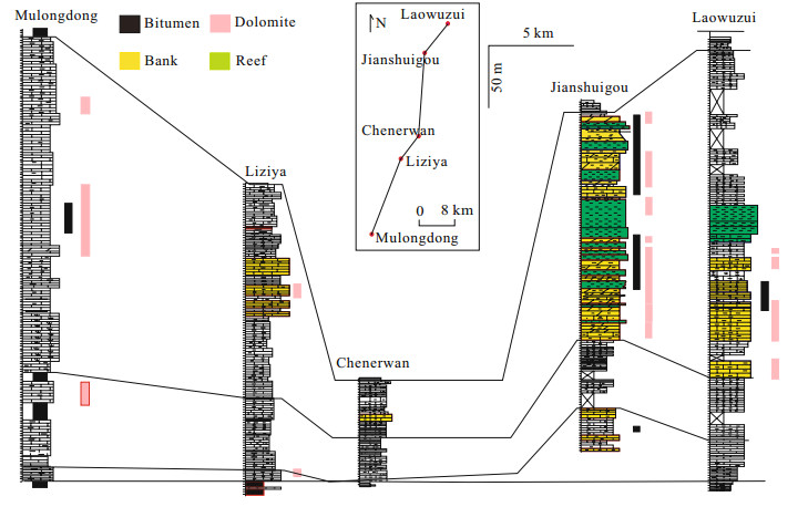
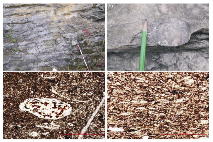
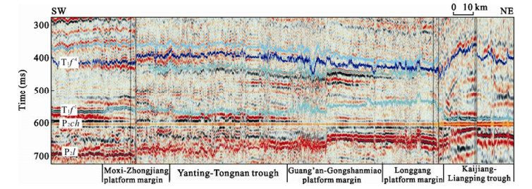
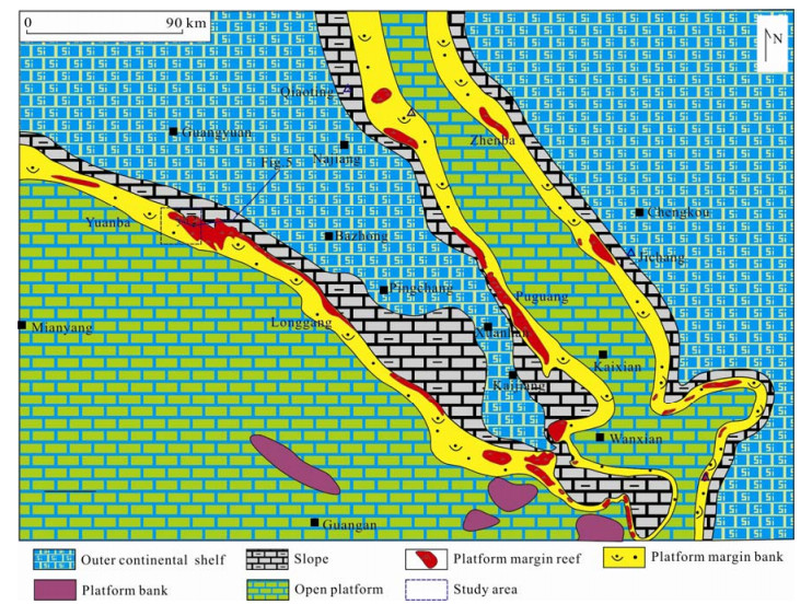
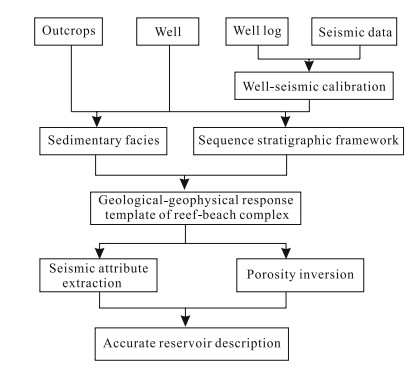
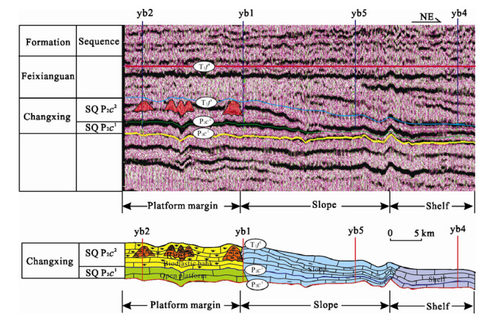
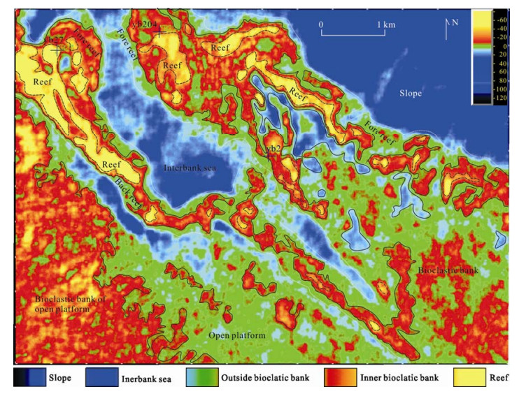
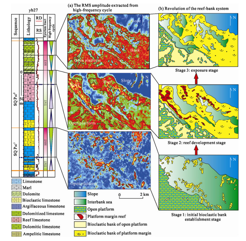
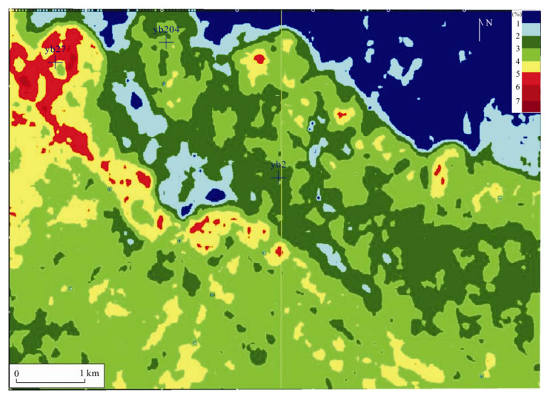
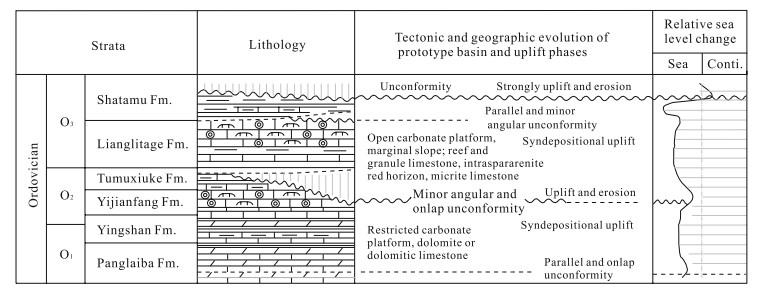
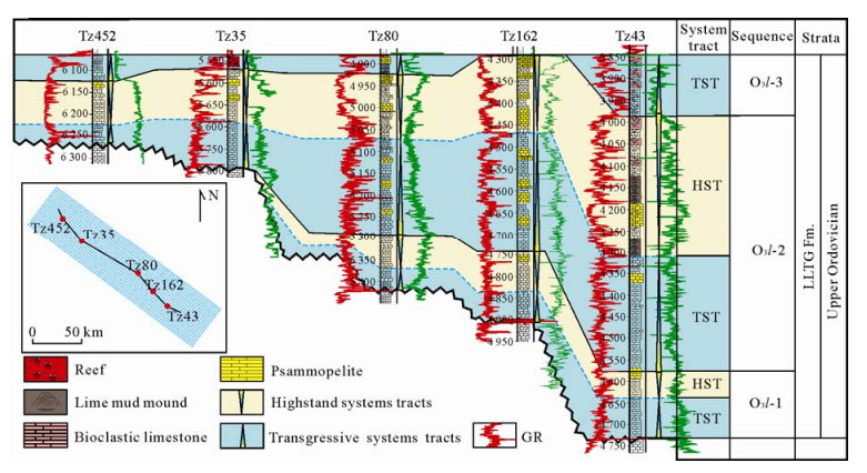
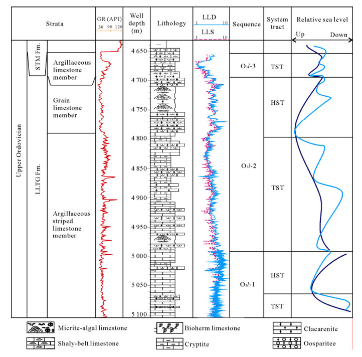
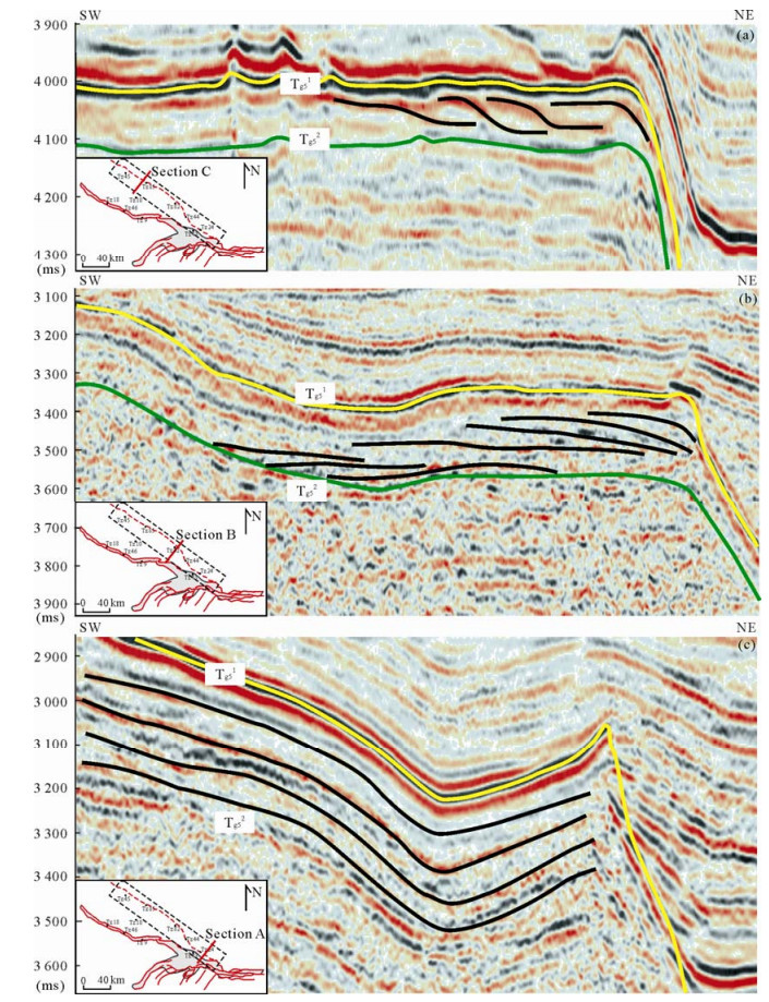
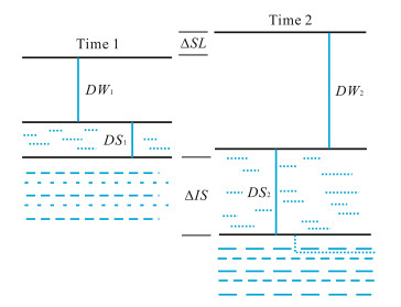
Reef-bank of Sichuan (四川) basin have been explored along the platform margin belt on both sides of the Kaijiang (开江)-Liangping (梁平) trough for a long time. Correspondingly,a series of major breakthroughs have been obtained and a number of large oil and gas fields have been found. After the breakthroughs of Kaijiang-Liangping trough,how reef-bank exploration will proceed? Is there another "Kaijiang-Liangping trough" in Sichuan basin? Previous research shows that Sichuan basin underwent intracratonic rift and basement fault activities in Late Permian,developing a paleogeography framework of "three uplifts and three depressions" under the background of the regional large ramp,including Exi (鄂西)-Chengkou (城口) trough,Kaijiang-Liangping trough and Yanting (盐亭)-Tongnan (潼南) trough. Based on sedimentology and tectonics dynamics analysis,data of drillings,outcrops and seismic,Yanting-Tongnan trough has been discovered in central Sichuan basin in our study which distributes from Mianzhu (绵竹),Jiangyou (江油) in western Sichuan basin through Nanchong (南充) to Guang'an (广安),as long as about 210 km,extending in NW-SE nearly paralleling to Kaijiang-Liangping trough,opening to the sea north-westward,and gradually pinchout to the east platform. Similar to Kaijiang-Liangping trough,another platform margin reef belt distributes along a U-shape belt around Yanting-Tongnan trough,which is expected to become another natural gas accumulation zone after the platform margin around Kaijiang-Liangping trough. The discovery of Yanting-Tongnan trough expands favorable reef exploration area from original 2×10⁴ km2 on both sides of Kaijiang-Liangping trough to more than 6×10⁴ km2 in Yanting-Tongnan trough platform margin belt and Kaijiang-Liangping platform margin belt,greatly enlarging the reef exploration field. But compared to Kaijiang-Liangping trough,Yanting-Tongnan trough is relatively shallower and smaller,and the scale and quality of reef-bank reservoirs in its margin belt is a little poor relatively. Therefore,much research should be done timely such as comparative study of two troughs,detailed research of formation and evolution of the trough,regularity of reef migration,meticulous depiction of reef-bank reservoir size and distribution in order to obtain major breakthroughs around the Yanting-Tongnan trough.
Seismic image prediction of Cenozoic reef-banks in the Northwestern South China Sea
Ping Chen, Yongchao Lu, Zhenfeng Wang, Lei Chen
2012, 23(4): 597-611. doi: 10.1007/s12583-012-0277-y
Abstract:
The Cenozoic reef-banks reservoir in Qiongdongnan (琼东南) basin is one of the most profitable targets worthy of prospecting in the deep water area of the northwestern South China Sea. In this study,the characteristics of organic reef-like reflectors in southern uplift area of Qiongdongnan basin are analyzed based on the latest 2D and 3D seismic data. It is found that reef-like reflectors in Qiongdongnan basin show high-amplitude moundy continuous reflection at the top and the bottom,chaotic reflection inside the reef-like reflector and there is obviously speed difference between reef-like reflector body and surrounding rock. Combining the geological setting of reef and comparative analysis,the reef-like reflectors are considered to be the reef-banks. Furthermore,the results show that there are three kinds of reef structures in the southern uplift area of Qiongdongnan basin: the fault controlling structure,the fault flexure structure and the carbonate ramp structure. Each structure has its own grow-units that can reveal the growth process of the reef in order. The distribution of reef-like reflectors in space shows an arc belt pattern. According to this,four reef arc belts are identified,and their spatial trends are thought to have a good relationship with the buried fault. The internal structure constitution and the growth state of reef-like reflectors are mainly controlled by the geomorphology and monsoon-ocean current. The result has an instructive significance to oil-gas exploration of organic reef not only in Qiongdongnan basin,but also even in deep water areas of the South China Sea.
Seismic Sedimentology Study in the High-Resolution Sequence Framework—A Case Study of Platform Margin Reef-Beach System of Changxing Formation, Upper Permian, Yuanba Area, Northeast Sichuan Basin, China
Lei Chen, Yongchao Lu, Tonglou Guo, Fengcun Xing, Yangquan Jiao
2012, 23(4): 612-626. doi: 10.1007/s12583-012-0278-x
Abstract:
The Yuanba (元坝) area is considered another potential large-scale reef-bank gas field following the Puguang (普光) field. However,there are lots of difficulties on the spatial and temporal distribution of reef-beach and the detailed prediction of the effective reservoir in the sequence stratigraphic framework. In this paper,based on the seismic data,well,log and core,we conduct a high-resolution sequence division and build an isochronal sequence stratigraphic framework for the Changxing (长兴) Formation by the methods of wavelet transformation,FMI,etc.. Then,the corresponding relationship among the lithologic facies,logging facies,seismic facies,seismic attribute facies and reservoir of Changxing Formation were established through well-seismic calibration and geological-geophysical modeling. Furthermore,detailed study on the spatial and temporal distribution of microfacies of the reef-beach was carried out by means of seismic attribute extraction. Meanwhile,combined with impedance inversion,the spatial distribution of porosity of reef-beach reservoir was predicted. The results show that the revolution of the reef-beach system contains three stages which are initial bioclastic bank establishment stage,reef development stage and exposure stage. Also,porosity inversion shows that the region with high value of porosity is located in the reef cap,fore reef and back reef.
Stratigraphic Architecture and Computer Modelling of Carbonate Platform Margin, Late Ordovician Lianglitage Formation, Central Tarim Basin
Hao Li, Changsong Lin, Yanmei Zhang, Rongxi Zhang, Zhifeng Rui, Lili Huang
2012, 23(4): 627-638. doi: 10.1007/s12583-012-0279-9
Abstract:
According to the different geometries and reflected characteristics in the seismic sections,the carbonate platform margin of the northern slope can be summarized as three basic depositional architectures in the Late Ordovician Lianglitage (良里塔格) Formation of the Tazhong (塔中) uplift. The type one mainly located in the west of the carbonate platform margin,and it showed obvious imbricate progradation from the interior to the margin of the platform. The type two was in the middle of the carbonate platform margin,which showed retrogradational stacking pattern in the same transgressive systems tract period,and the slope strata of the platform margin showed progradational sequence in the highstand systems tract period. The type three located in the east of the carbonate platform margin,and it showed the parallel aggradational architecture. The crossing well section along the northern slope of the Tazhong carbonate platform showed that the depositional thickness became thinner from the east to the west. The thickest belt located in the east of the platform margin,and became thinner rapidly towards the basin and the platform interior. These indicated that the paleogeomorphology of the Tazhong uplift was probably high in the west and low in the east during the period of the Late Ordovician Lianglitage Formation. According to the interpretation of seismic profiles and the computer modelling result,the depositional architectures of sequence O3 l-2 showed aggradation,retrogradation and progradation from the east to the west of the carbonate platform margin during the transgression period. This meant that the accommodation became smaller gradually from the east to the west along the northern carbonate platform margin of the Tazhong uplift. The difference of the accommodation was probably caused by the difference of tectonic subsidence. Also,computer-aided modelling can be used to deeply understand the importance of various control parameters on the carbonate platform depositional architectures and processes.