| Citation: | Ye Yuan, Timothy M. Kusky, Sankaran Rajendran. Tertiary and quaternary marine terraces and planation surfaces of northern Oman: Interaction of flexural bulge migration associated with the Arabian-Eurasian collision and eustatic sea level changes. Journal of Earth Science, 2016, 27(6): 955-970. doi: 10.1007/s12583-015-0656-2

|

| Abdeen, M. M., Allison, T. K., Abdelsalam, M. G., et al., 2001. Application of ASTER Band Ratio Images for Geological Mapping in Arid Regions: The Neoproterozoic Allaqi Suture, Egypt. Proceedings of Geological Society of America Annual Meeting, Boylston. 33(6): 123 http://www.researchgate.net/publication/286711692_Application_of_ASTER_band-ratio_images_for_geological_mapping_in_arid_regions_The_Neoproterozoic_Allaqi_Suture |
| Abrams, M. J., Rothery, D. A., Pontual, A., 1988. Mapping in the Oman Ophiolite Using Enhanced Landsat Thematic Mapper Images. Tectonophysics, 151(1-4): 387-401. doi: 10.1016/0040-1951(88)90254-5 |
| Al-Lazki, A., Seber, D., Sandvol, E., et al., 2002. A Crustal Transect across the Oman Mountains on the Eastern Margin of Arabia. Geoarabia, 7(1): 47-78 http://www.researchgate.net/publication/268176191_A_crustal_transect_across_the_Oman_Mountains_on_the_eastern_margin_of_Arabia |
| Alsdorf, D. E., Smith, L. C., 1999. Interferometric SAR Observations of Ice Topography and Velocity Changes Related to the 1996 Gjálp Subglacial Eruption, Iceland. International Journal of Remote Sensing, 20(15-16): 3031-3050. doi: 10.1080/014311699211606 |
| Amer, R., Kusky, T. M., Ghulam, A., 2010. Lithological Mapping in the Central Eastern Desert of Egypt Using ASTER Data. Journal of African Earth Sciences, 56 (2-3): 75-82. doi: 10.1016/j.jafrearsci.2009.06.004 |
| Boote, D. R. D., Mou, D., Waite, R. I., 1990. Structural Evolution of the Suneinah Foreland, Central Oman Mountains. Geological Society, London, Special Publications, 49(1): 397-418. doi: 10.1144/gsl.sp.1992.049.01.25 |
| Bradley, D. C., Kusky, T. M., 1986. Geologic Methods of Estimating Convergence Rates during Arc-Continent Collision. Journal of Geology, 94(5): 667-681. doi: 10.1086/629073 |
| Chappell, J., Omura, A., Esat, T., et al., 1996. Reconciliation of Late Quaternary Sea Levels Derived from Coral Terraces at Huon Peninsula with Deep Sea Oxygen Isotope Records. Earth and Planetary Science Letters, 141(1): 227-236. doi: 10.1016/0012-821x(96)00062-3 |
| Crósta, A. P., Filho, C. R. D. S., 2003. Searching for Gold with ASTER. Earth Observation Magazine, 12 (5): 38-41 http://www.researchgate.net/publication/285788643_Searching_for_gold_with_ASTER |
| Crósta, A. P., Moore, M. J., 1990. Enhancement of Landsat Thematic Mapper Imagery for Residual Soil Mapping in SW Minas Gerais State Brazil-A Prospecting Case History in Greenstone Belt Terrain. Proceedings of Thematic Conference on Remote Sensing for Exploration Geology- Methods, Integration, Solutions, 7th, Calgary. 1173-1187 |
| Deif, A., El-Hussain, I., Al-Jabri, K., et al., 2013. Deterministic Seismic Hazard Assessment for Sultanate of Oman. Arabian Journal of Geosciences, 6(12): 4947-4960 doi: 10.1007/s12517-012-0790-4 |
| DeMets, C., Gordon, R. G., Argus, D. F., 2010. Geologically Current Plate Motions. Geophysical Journal International, 181(1): 1-80. doi: 10.1111/j.1365-246x.2009.04491.x |
| Gabr, S., Ghulam, A., Kusky, T. M., 2010. Detecting Areas of High-Potential Gold Mineralization Using ASTER Data. Ore Geological Reviews, 38(1): 59-69. doi: 10.1016/j.oregeorev.2010.05.007 |
| Gardner, R. A. M., 1988. Aeolianites and Marine Deposits of the Wahiba Sands: Character and Paleoenvironments, Journal of Oman Studies, 3: 75-94 http://www.researchgate.net/publication/285816687_Aeolianites_and_marine_deposits_of_the_Wahiba_Sands_Character_and_palaeoenvironments |
| Gillespie, A. R., Kahle, A. B., Walker, R. E., 1986. Color Enhancement of Highly Correlated Images. I. Decorrelation and HSI Contrast Stretches. Remote Sensing of Environment, 20(3): 209-735 doi: 10.1016/0034-4257(86)90044-1 |
| Glennie K. W., Boeuf, M. G. A., Hughes-Clarke, M. W., et al., 1973. Late Cretaceous Nappesin Oman Mountains and Their Geologic Evolution. AAPG Bulletin, 57(1): 5-27. doi: 10.1306/819a4240-16c5-11d7-8645000102c1865d |
| Glennie, K. W., 2005. The Geology of the Oman Mountains: An Outline of Their Origin. Bucks: Scientific, Norwalk. 110 |
| Glennie, K. W., Boeuf, M. G. A., Hughes-Clarke, M. W. M., et al., 1990. Inter-Relationship of Makran-Oman Mountains Belts of Convergence. Geological Society Special Publications, 49(1): 773-786. doi: 10.1144/gsl.sp.1992.049.01.47 |
| Haghipour, N., Burg, J. P., 2014. Geomorphological Analysis of the Drainage System on the Growing Makran Accretionary Wedge. Geomorphology, 209: 111-132. doi: 10.1016/j.geomorph.2013.11.030 |
| Hanna, S. S., 1986. The Alpine (Late Cretaceous and Tertiary) Tectonic Evolution of the Oman Mountains: A Thrust Tectonic Approach. Symposium on the Hydrocarbon Potential of Intense Thrust Zone, OAPEC, Kuwait. 2: 125-174 |
| Hannss, C., Rahle, W., Kurschner, H., 1991. The Capital Area of North Oman: Basic Features of the Younger Caenozoic Relief Development on the Seaside of Central Oman. L. Reihert |
| Hecker, C. A., van der Meijde, M., van der Werff, H. M. A., et al., 2008. Assessing the Influence of Reference Spectra on Synthetic SAM Classification Results. IEEE Transactins on Geoscience and Remote Sensing, 46(12): 4162-4172. doi: 10.1109/tgrs.2008.2001035 |
| Khan, S. D., Glenn, N., 2006. New Strike Slip Faults and Litho-Units Mapped in Chitral (N. Pakistan) Using Field and ASTER Data Yield Regionally Significant Results. International Journal of Remote Sensing, 27(20): 4495-4512. doi: 10.1080/01431160600721830 |
| Khan, S. D., Mahmood, K., Casey, J. F., 2007. Mapping of Muslim Bagh Ophiolite (Pakistan) Using New Remote Sensing and Field Data. Journal of Asian Earth Sciences, 30(2): 333-343. doi: 10.1016/j.jseaes.2006.11.001 |
| Kruse, F. A., Boardman, J. W., Hunnington, J. F., 2003. Comparison of Airborne Hyperspectral Data and EO-1 Hyperion for Mineral Mapping. IEEE Transactins on Geoscience and Remote Sensing, 41(6): 1388-1400. doi: 10.1109/tgrs.2003.812908 |
| Kruse, F. A., Lefkoff, A. B., Boardman, J. W., et al., 1993. The Spectral Image Processing System (SIPS)-Interactive Visualization and Analysis of Imaging Spectrometer Data. Remote Sensing of Environment, 44(2): 145-163. doi: 10.1016/0034-4257(93)90013-n |
| Kusky, T. M., Ramadan, T., 2002. Structural Controls on Neoproterozoic Mineralization in the SE Desert, Egypt: An Integrated Field, Landsat TM, and SIR C/X SAR Approach. Journal of African Earth Sciences, 35(1): 107-121. doi: 10.1016/s0899-5362(02)00029-5 |
| Kusky, T. M., Robinson, C., El-Baz, F., 2005. Tertiary-Quaternary Faulting and Uplift in the Northern Oman Hajar Mountains. Journal of the Geological Society, London, 162(4): 871-888. doi: 10.1144/0016-764904-122 |
| Li, H., Huang, X. Y., Deng, Q. L., et al., 2012. Mapping of Planation Surfaces in the West Region of Hubei Province Using the DEM Painted Relief Model. In: Kusky, T. M., Xiang, W., eds., Bedrock Geology, Neotectonics, and Geological Hazards in the Three Gorges Area, China. Journal of Earth Science, 23(5): 719-730 |
| Li, Z. Z., Wang, D. M., Liu, D. C., et al., 2015. Hyperspectral Remote Sensing Technology and Its Progress in Resources Exploration. Earth Science-Journal of China University of Geosciences, 40(8): 1287-1294 doi: 10.3799/dqkx.2015.108 |
| Loughlin, W. P., 1991. Principal Component Analysis for Alteration Mapping. Photogrammetric Engineering and Remote Sensing, 57(9): 1163-1169 http://www.researchgate.net/publication/279543445_Principal_component_analysis_for_alteration_mapping |
| Magilligan, F. J. B., Gomez, L. A. K., Mertes, L. C., et al., 2002. Geomorphic Effectiveness, Sandur Development, and the Pattern of Landscape Response during Jokulhlaups: Skeiðarársandur, Southeastern Iceland. Geomorphology, 44(1-2): 95-113. doi: 10.1016/s0169-555x(01)00147-7 |
| Mann, A., Hanna, S. S., Nolan, S. C., 1990. The Post-Campanian Tectonic Evolution of the Central Oman Mountains: Tertiary Extension of the Eastern Arabian Margin. Geological Society, London, Special Publications, 49(1): 549-563. doi: 10.1144/gsl.sp.1992.049.01.33 |
| Matthews, J. P., Jones, A. S., 1992. Mapping the Xigaze (Tibet) Ophiolite Complex with Landsat Thematic Mapper Data. Journal of Himalayan Geology, 3: 97-101 http://www.researchgate.net/publication/281362339_Mapping_the_Xigaze_Tibet_ophiolite_complex_with_Landsat_Thematic_Mapper_data |
| Philip, G., Ravindran, K. V., Mathew, J., 2003. Mapping the Nidar Ophiolite Complex of the Indus Suture Zone, Northwestern-Trans Himalaya Using IRS-1C/1D Data. International Journal of Remote Sensing, 24(24): 4979-4994 doi: 10.1080/0143116021000023862 |
| Rajendran, S., Al-Khirbash, S., Pracejus, B., et al., 2012. ASTER Detection of Chromite Bearing Mineralized Zones in Samail Ophiolite Massifs of the Northern Oman Mountain: Exploration Strategy. Ore Geological Reviews, 44(2): 121-135 http://www.sciencedirect.com/science/article/pii/S016913681100117X |
| Rajendran, S., Hersi, O. S., Al-Harthy, A. R., et al., 2011. Capability of Advanced Spaceborne Thermal Emission and Reflection Radiometer (ASTER) on Discrimination of Carbonates and Associated Rocks and Mineral Identification of Eastern Mountain Region (Saih Hatat Window) of Sultanate of Oman. Carbonates Evaporites, 26(4): 351-364. doi: 10.1007/s13146-011-0071-4 |
| Rajendran, S., Nasir, S., 2013. ASTER Spectral Analysis of Ultramafic Lamprophyres (Carbonatites and Aillikites) within the Batain Nappe, Northeastern Margin of Oman-A Proposal Developed for Spectral Absorption. International Journal of Remote Sensing, 34(8): 2763-2795. doi: 10.1080/01431161.2012.748941 |
| Rajendran, S., Nasir, S., 2014. ASTER Spectral Sensitivity of Carbonate Rocks-Study in Sultanate of Oman. Advances in Space Research, 53(4): 656-673 doi: 10.1016/j.asr.2013.11.047 |
| Rajendran, S., Nasir, S., 2015. Mapping of High Pressure Metamorphics in the AsSifah Region, NE Oman Using ASTER Data. Advances in Space Research, 55(4): 1134-1157 doi: 10.1016/j.asr.2014.11.026 |
| Rajendran, S., Nasir, S., Kusky, T. M., et al., 2013. Detection of Hydrothermal Mineralized Zones Associated with Listwaenites Rocks in the Central Oman Using ASTER Data. Ore Geological Reviews, 53(8): 470-488. doi: 10.1016/j.oregeorev.2013.02.008 |
| Rajendran, S., Nasir, S., Kusky, T. M., et al., 2014. Remote Sensing Based Approach for Mapping of CO2 Sequestered Regions in Samail Ophiolite Massifs of the Sultanate of Oman. Earth-Science Reviews, 135(4): 122-140. doi: 10.1016/j.earscirev.2014.04.004 |
| Ravaut, P., Bayer, R., Hassani, R., et al., 1997. Structure and Evolution of the Northern Oman Margin: Gravity and Seismic Constraints over the Zagros-Makran-Oman Collision Zone. Tectonophysics, 279(1-4): 253-280. doi: 10.1016/s0040-1951(97)00125-x |
| Richards, J. A., 1993. Remote Sensing Digital Image Analysis: An Introduction. Springer-Verlag, Berlin. 340 |
| Richards, J. A., Jia, X. P., 1999. Remote Sensing Digital Image Analysis, Third Ed. Springer, Berlin. 363 |
| Robertson, A., 1987. The Transition from a Passive Margin to an Upper Cretaceous Foreland Basin Related to Ophiolite Emplacement in the Oman Mountains. Geological Society of America Bulletin, 99(5): 633-653 doi: 10.1130/0016-7606(1987)99<633:TTFAPM>2.0.CO;2 |
| Robinson, C. A., El-Baz, F., Kusky, T. M., et al., 2007. Role of Fluvial and Structural Processes in the Formation of the Wahiba Sands, Oman: A Remote Sensing Perspective. Journal of Arid Environments, 69(4): 676-694. doi: 10.1016/j.jaridenv.2006.11.015 |
| Rokos, D., Argialas, D., Mavrantza, R., et al., 2000. Structural Mapping and Analysis for a Preliminary Investigation of Possible Gold Mineralization by Using Remote Sensing and Geochemical Techniques in a GIS Environment: Island of Lesvos, Hellas. Natural Resources Research, 9(4): 277-293 doi: 10.1023/A:1011505326148 |
| Rollinson, H. R., Searle, M. P., Abbasi, I. A., et al., 2014. Tectonic Evolution of the Oman Mountains. Geological Society of London Special Publication, 392(1): 1-7 doi: 10.1144/SP392.1 |
| Rothery, D. A., 1984. The Role of Landsat Multispectral Scanner (MSS) Imagery in Mapping the Oman Ophiolite. Geological Society, London, Special Publications, 13(1): 405-413. doi: 10.1144/gsl.sp.1984.013.01.33 |
| Rowan, L. C., Mars, J. C., 2003. Lithologic Mapping in the Mountain Pass Area, California Using Advanced Spaceborne Thermal Emission and Reflection Radiometer (ASTER) Data. Remote Sensing of Environment, 84(3): 350-366 doi: 10.1016/S0034-4257(02)00127-X |
| Rowan, L., Hook, S. J., Abrams, M. J., et al., 2003. Mapping Hydrothermally Altered Rocks at Cuprite, Nevada, Using the Advanced Spaceborne Thermal Emission and Reflection Radiometer (ASTER), a New Satellite-Imaging System. Economic Geology, 98(5): 1019-1027 doi: 10.2113/gsecongeo.98.5.1019 |
| Siddall, M., Rohling, E. J., Almogi-Labin, A., et al., 2003. Sea-Level Fluctuations during the Last Glacial Cycle. Nature, 423(6942): 853-858 doi: 10.1038/nature01690 |
| Stollhofen, H., Stanistreet, I. G., von Hagke, C., et al., 2014. Pliocene-Pleistocene Climate Change, Sea Level and Uplift History Recorded by the Horingbaai Fan-Delta, NW Namibia. Sedimentary Geology, 309(6): 15-32 http://www.sciencedirect.com/science/article/pii/S0037073814000992 |
| Van den Berg, A., Segal, G., Yuen, D. A., 2015. SEPRAN: A Versatile Finite-Element Package for a Wide Variety of Problems in Geosciences. Journal of Earth Science, 26(1): 89-95 doi: 10.1007/s12583-015-0508-0 |
| Whitney, B. B., Hengesh, J. V., 2015. Geomorphological Evidence for Late Quaternary Tectonic Deformation of the Cape Region, Coastal West Central Australia. Geomorphology, 84: 160-174 http://www.sciencedirect.com/science/article/pii/S0169555X15002123 |
| Williams, R. S., Hall, D. K., Sigurdsson, O., et al., 1997. Comparison of Satellite-Derived with Ground-Based Measurements of the Fluctuations of the Margins of Vatnajokull, Iceland, 1973-1992. Annals of Glaciology, 20(3): 53-71 http://www.researchgate.net/publication/319962550_Comparison_of_satellite-derived_with_ground-based_measurements_of_the_fluctuations_of_the_margins_of_Vatnajokull_Iceland_1973-92 |
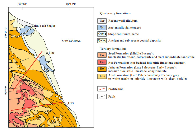
| Wyns, R., Bechennec, F., Le Metour, J., et al., 1992. Geological Map of Sur, Sheet NF 40-08, Scale 1 : 250 000. Directorate General of Minerals, Ministry of Petroleum and Minerals, Muscat |
| Zha, F. L., Ma, M., Chen, S. B., et al., 2015. Remote Sensing Lithologic Classification of Multispectral Data Based on the Vegetation Inhibition Method in the Vegetation Coverage Area. Earth Science-Journal of China University of Geosciences, 40(8): 1403-1408 doi: 10.3799/dqkx.2015.125 |
Figures(12) / Tables(1)
Copyright © 2013-2020 Journal of Earth Science 鄂ICP备15021562号-2
Tel: +86-27-67885075 Fax: +86-27-67885075 E-mail: xbb@cug.edu.cn
Address: Editorial Office of Journal, China University of Geosciences, Yujiashan, Wuhan, Hubei 430074, P. R. China
Supported by:
Beijing Renhe Information Technology Co. Ltd
E-mail:
info@rhhz.net


 DownLoad: