Advanced Search

Indexed by SCI、CA、РЖ、PA、CSA、ZR、etc .

2016 Vol. 27, No. 6

CONTENTS
2016, 27(6): .
Abstract:
Special Column on Tectonics of Turkey and Iran and Comparison with Other Tethyan Domains
The tauride ophiolites of Anatolia (Turkey): A review
Osman Parlak
2016, 27(6): 901-934. doi: 10.1007/s12583-016-0679-3
Abstract:
The Tauride ophiolites lie on the northern and southern flanks of an E-W-trending Tauride carbonate platform. They mainly consist of three tectonic units namely in ascending order, ophiolitic mélange, sub-ophiolitic metamorphic sole and oceanic lithospheric remnants. They were generated above intra-oceanic subduction zones and emplaced over the Tauride carbonate platform from different Neotethyan oceanic basins in the Late Cretaceous. Tauride ophiolites from west to east are described and reviewed. All are underlain by well-preserved dynamothermal metamorphic soles of varied structural thicknesses up to 500 m that have a constant structural position between ophiolitic mélange below and harzburgitic mantle tectonites above and display typical inverted metamorphic sequences from amphibolite facies above to greenschist facies below. The metamorphic soles are shown to have evolved during the initiation of subduction and emplacement processes. In the Pozantı- Karsantı area the contact between the metamorphic sole and the overlying serpentinized harzburgites is characterized by a 1.5–2-m-thick zone of sheared serpentinized harzburgitic mantle intercalated with amphibolites and cut by thick mafic dykes (7–8 m) which postdate intraoceanic metamorphism and high-temperature ductile deformation. This contact is interpreted as an intra-oceanic decoupling surface along which volcanics from the upper levels of the down-going plate were metamorphosed to amphibolite facies and accreted to the base of the hanging wall plate. The metamorphic soles and overlying ophiolitic rocks were intruded by numerous isolated post-metamorphic diabase dykes filled by island arc tholeiitic magma. Subduction initiation and roll-back processes best explain the structural and petrological relationships of Late Cretaceous ophiolite genesis, metamorphic sole formation and subsequent dyke emplacement of the Tauride ophiolites.
Petrology and geochemistry of diabasic dikes and andesitic-basaltic lavas in Noorabad-Harsin ophiolite, SE of Kermanshah, Iran
Zahra Tahmasbi, Masoud Kiani, Ahmad Ahmadi Khalaji
2016, 27(6): 935-944. doi: 10.1007/s12583-016-0686-4
Abstract:
The Noorabad-Harsin ophiolite is a part of the eastern Mediterranean-Zagros-Oman Tethyan ophiolites. This area is located in the south-southwest of the main Zagros thrust zone. This ophiolite consists of peridotites, serpentinites and pegmatite gabbros as mantle sequence whereas crustal sequence is composed of locally layered gabbros, isotropic gabbros, sheeted dike complex, basaltic to andesitic lavas and sedimentary rocks (radiolarites and Late Cretaceous pelagic limestones). The diabase dikes are enriched in LREE relative to HREE (La(n)/Yb(n)=1.7–3.3). Also, the andesites are enriched in LREE relative to HREE (La(n)/Yb(n)=3.1–5.37) and the pillow lavas are enriched in LILE (Th(n)/La(n)=2.1) while show a depletion in HFSE (Nb(n)/La(n)=0.07–0.2). The basaltic-andesitic lavas exhibiting mainly calc-alkaline, with minor island-arc tholeiitic affinities, are characterized by enrichment in LILE and LREE and depletion in HFSE. These geochemical characteristics compared with other Tethyan ophiolites along the Bitlis-Zagros suture zone reveal a suprasubduction zone environment for the genesis of the Noorabad-Harsin ophiolites.
Geomorphometric evidence of an active pop-up structure along the sabzpushan fault zone, Zagros mountains, SW Iran
Ali Faghih, Iman Nezamzadeh, Timothy M. Kusky
2016, 27(6): 945-954. doi: 10.1007/s12583-016-0663-y
Abstract:
Evaluation of active tectonism by means of geomorphic indices has provided crucial semi-quantitative data for evaluating seismic hazards in a fault zone in a semiarid area of the Zagros Mountains of Iran where tectonic rates are low-to-moderate and there are few Quaternary dates. Quaternary activity along the seismically active but poorly understood Sabzpushan fault zone (SFZ) has been investigated. The SFZ consists of two dextral strike-slip faults, the Zafarabad and Kafari faults. Geomorphic indices including mountain front sinuosity, valley asymmetry factor, hypsometric integral, valley floor width to valley height ratio and stream length gradient index were used to assess the effects of active reverse faults which control the topographic relief and Quaternary activity. Geomorphometric and field evidence reveal that the Quaternary activity and topographic relief of the study area are controlled by two reverse faults, the North and South Sabzpushan reverse faults, which have formed a pop-up structure in the contractional step-over area between the Zafarabad and Kafari dextral strikeslip faults as a consequence of oblique convergence between the Afro-Arabian and Iranian plates accommodated by the North and South Sabzpushan thrust faults.
Tertiary and quaternary marine terraces and planation surfaces of northern Oman: Interaction of flexural bulge migration associated with the Arabian-Eurasian collision and eustatic sea level changes
Ye Yuan, Timothy M. Kusky, Sankaran Rajendran
2016, 27(6): 955-970. doi: 10.1007/s12583-015-0656-2
Abstract:
The northeastern Arabian passive margin is being subducted beneath the Zagros and Makran of Iran. A flexural bulge related to the weight of the Makran has migrated at 4 cm/a through the previously uplifted Hajar Mountains of Oman as this active convergence and collision between Arabia and Eurasia progresses, adding approximately another 500 meters of relief, and forming a series of uplifted marine terraces, alluvial terraces, and planation surfaces that record the passage of the bulge. We use a combination of field studies, remote sensing and GIS to map and better-understand these terraces, and elucidate how the tectonics of bulge migration, down-to-trench normal faulting, and eustatic sea level changes have interacted to produce the extant geomorphic features on the inner slope of the flexural bulge as it sinks into the foredeep of the Gulf of Oman. We speculate those terraces that were uplifted on the outer slope of the forebulge as it initially migrated through the passive margin (affected by ophiolite obduction in the Cretaceous) 3.75–7.5 Ma ago are now sinking on the inner slope of the forebulge (corresponding to the outer trench slope in the foredeep), and have been partly covered by Quaternary marine terraces related to a Weichselian sea level high stand. Both the Tertiary and Quaternary terraces are cut by faults related to the active collision, confirming that there is a significant risk of moderate earthquakes in the region.
Evaluation of slip rate on Astara fault system, North Iran
Amir Barzegari, Rasoul Esmaeili, Mohammad Ebrahimi, Ali Faghih, Manucher Ghorashi, Hamid Nazari
2016, 27(6): 971-980. doi: 10.1007/s12583-016-0680-x
Abstract:
Due to its strategic location, the Astara fault system (AFS), which is located in Iran, has given rise to a number of earthquakes. In spite of its frequent seismic events, limited information is available for AFS. Slip rate is one of the important variables for future scrutiny of seismic risk of this fault system. The main objective of this research is to study slip rates at intermediate and short terms for this fault system using geological, geodetic observations and empirical method. Using the geological data, the intermediate-term horizontal and vertical slip rates for AFS have been determined to be 2.8±0.2 and 0.27±0.03 mm/year, respectively. In addition, the short-term slip rates of the fault, based on the geodetic method (using displacement values of two GPS stations: HASH and DAMO) and assuming attenuation of 60% (to fold the sediment of South Caspian Basin and shortening of Talesh Mountain range), determined to be 1.23±0.03 and 2.05±0.05 mm/year for the horizontal and vertical slips, respectively. Finally, evaluation of the slip rate using empirical relationship yields 10 mm/year for the entire fault system, which seems rather implausible.
Tectonic study of the Sub-Himalayas based on geophysical data in Azad Jammu and Kashmir and northern Pakistan
Muhammad Rustam Khan, Fahad Hameed, Muhammad Saleem Mughal, Muhammad Basharat, Sohail Mustafa
2016, 27(6): 981-988. doi: 10.1007/s12583-016-0681-9
Abstract:
The tectonic study based on geophysical data has been carried out in Sub-Himalayas in Azad Jammu and Kashmir and northern Pakistan. A series of thin skinned and thick skinned faults have been delineated in the investigated area on the basis of present study. In the study area compressional stresses caused by the collisional of Indian and Eurasian plates developed the northwestsoutheast trending faults which are Shaheed Gala thrust, Bagh basement fault, Kashmir boundary thrust and Kawai fault or Indus Kohistan seismic zone. The crustal thickness increases towards north due to the stacking of the thrust sheets along these faults. The Murree Formation thrusts over the Siwaliks molasse along the Shaheed Gala thrust. This fault dips at an angle of 43º northeast and joins the thick skinned Bagh basement fault in subsurface which are penetrated up to Moho depth. In the northeast of Bagh basement fault the northwest-southeast trending Kashmir boundary thrust has been delineated in the sedimentary-metasedimentary wedge which joins the Indus Kohistan seismic zone in the subsurface. The present study suggested that the Kawai fault which is running within Murree Formation cuts 16 km thick sedimentary-metasedimentary wedge and also joins the Indus Kohistan seismic zone in the subsurface.
Metamorphic temperature investigation of coexisting calcite and dolomite marble-examples from Nikani Ghar marble and Nowshera Formation, Peshawar Basin, Pakistan
Muhammad Fahad, Yaseen Iqbal, Mohammad Riaz, Rick Ubic, Simon A. T. Redfern
2016, 27(6): 989-997. doi: 10.1007/s12583-015-0643-7
Abstract:
Using marble samples from the Nikani Ghar marble and Nowshera Formation from Northern Pakistan the determination of the temperature of metamorphism was undertaken with the help of calcite-dolomite solvus geothermometer. Two types of marbles, that is, calcite-dolomite marble and quartz-bearing calcite-dolomite marble were selected. Petrographic and scanning electron microscope analysis of dolomite samples indicated different grain sizes. X-ray diffraction technique indicated the calcites MgCO3 content up to 7.93 mol.%. Nikani Ghar marble samples have shown lower contents of MgCO3 as compared to samples from Nowshera Formation. The calcite-dolomite-quartz marble has also showed relatively lower MgCO3 content and hence rather low temperature (~500 ℃). The temperature reached during peak metamorphism of the investigated marble occurrence, based on calcitedolomite solvus was 628 ℃. Metamorphic temperatures derived from the present study were shown as a linear graph and values were in good agreement with the published literature.
Structural development of northwest Saudi Arabia using aeromagnetic and seismological data
Mohamed Fnais, Elkhedr Ibrahim, Essam Abd El-Motaal, Kamal Abdelrahman, Abdelmaguid Al-Heniedi, Khaled Al-Kahtany
2016, 27(6): 998-1007. doi: 10.1007/s12583-016-0904-0
Abstract:
High resolution aeromagnetic and seismological data constrained by field-based structural investigations have been used to map and delineate the structural elements that affected and shaped the Midyan area in the northwest part of Saudi Arabia. The area was divided into four major domains defined by NNE, NNW, NW and ENE trending faults identified by trends, patterns and intensity of magnetic anomalies. The ENE trending left-lateral strike-slip faults intersected by NNE trending faults are the predominant tectonic features in the Gulf of Aqaba coastal area and stop at the boundary of a central domain characterized by complexity in the pattern and intensity of magnetic anomalies, that may be attributed to heterogeneity of basement rocks containing complex igneous rock suites including diorite, gabbro, ultramafic and alkali granitic rocks. This domain is characterized by the presence of narrow linear magnetic anomalies that extend for kilometers in an NNW direction, indicating dikes intruded through NNW trending faults. These dikes become WNW-oriented near their northern termination by transfer of movement to WNW-oriented faults marking the northern termination of the Red Sea rift. It is believed that this fault zone is still experiencing neotectonic activity, as evident from recorded seismicity. The aeromagnetic structural results coincide with fault plane solutions for the largest earthquakes, confirming aeromagnetic interpreted trends and illustrating mixed mechanisms between extensional and strike-slip faulting. Thus the study area displays different mechanisms associated with different tectonic trends which show clearly in the structural patterns of the area.
Two comparable earthquakes produced greatly different coseismic landslides: The 2015 Gorkha, Nepal and 2008 Wenchuan, China events
Chong Xu, Xiwei Xu, Yingying Tian, Lingling Shen, Qi Yao, Xueqiang Huang, Junxue Ma, Xi Chen, Siyuan Ma
2016, 27(6): 1008-1015. doi: 10.1007/s12583-016-0684-6
Abstract:
The 2015 Gorkha Earthquake in Nepal and the 2008 Wenchuan Earthquake in China occurred at the south and southeast margins of the Tibetan Plateau, respectively. Both earthquakes had similar magnitudes of Mw 7.8 and 7.9, caused catastrophic loss of life and damage to property, and generated tens of thousands of landslides. Comparisons of pre- and post-quake satellite images supported by field investigations show that the Gorkha Earthquake triggered at least 2 064 large landslides (defined as covering an area ≥10 000 m2) over a ~35 600 km2 region with a volume of (444–584)×106 (average 509×106) m3 and total area of 44.78×10⁶ m2. In contrast, the Wenchuan Earthquake triggered 25 580 large landslides over a region of ~44 000 km2 with a volume of (7 128–9 479)×106 (average 8 219×106) m3 and a total area of about 670.65×10⁶ m2. Several controlling factors including topographic relief, slope steepness, and regional peak ground acceleration (PGA) were investigated to try to explain the great differences between the number, volume and area of the coseismic landslides associated with the two similar earthquakes. We found that the differences primarily arose from an unexpected factor, the dip angle of the seismogenic fault. This discovery should aid understanding the failure mechanisms of quake-triggered landslides, and suggests that more factors should be taken into consideration in estimating coseismic landslide volumes from earthquake magnitudes.
Detailed inventory mapping and spatial analyses to landslides induced by the 2013 Ms 6.6 Minxian earthquake of China
Yingying Tian, Chong Xu, Xiwei Xu, Jian Chen
2016, 27(6): 1016-1026. doi: 10.1007/s12583-016-0905-z
Abstract:
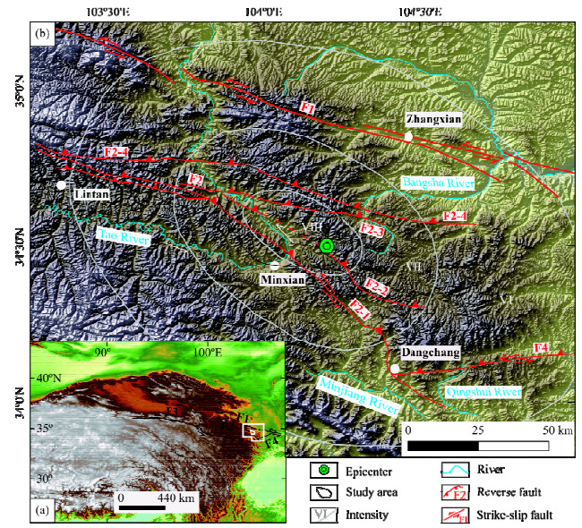
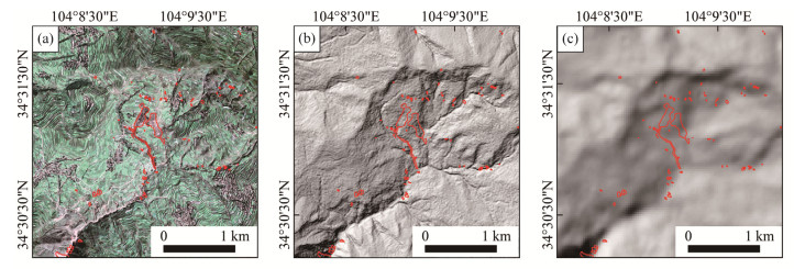
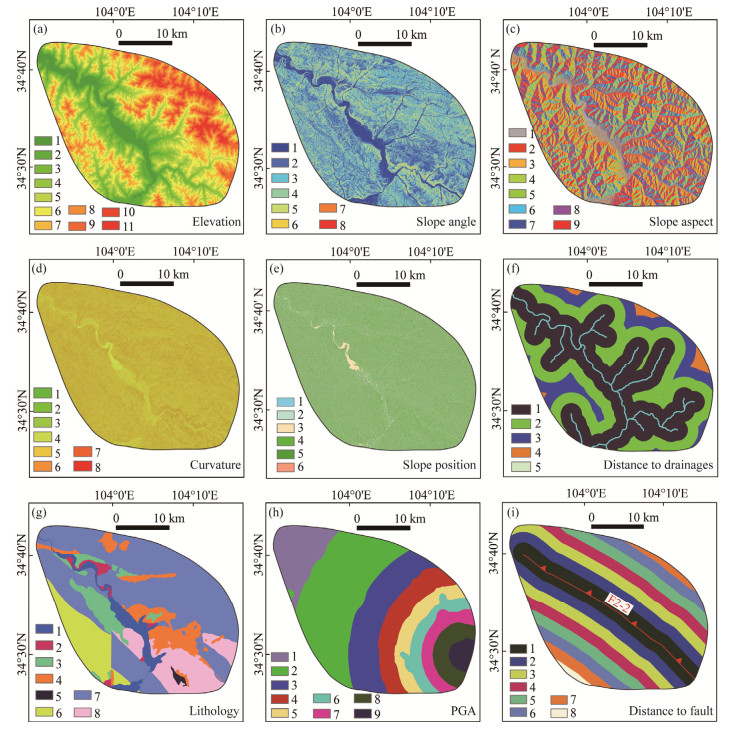
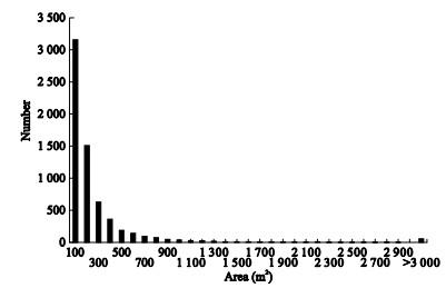
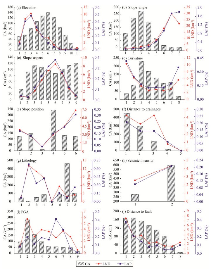
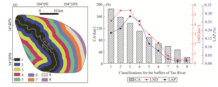
On July 22, 2013, an earthquake (Ms 6.6) occurred in Minxian, Gansu Province of China, causing a large number of landslides. Based on high resolution remote sensing images before and after this event, we made the visual interpretation to these coseismic landslides, and prepared a detailed inventory. The inventory registers totally 6 478 landslides in the study area. Of them, 3 322 landslides are larger than 100 m2. Based on 5 m resolution DEM, these landslides were used to perform spatial analyses using landslide number density (LND) and landslide area percentage (LAP). The results show that the highest LND and LAP values are in the elevation range of 2 300–2 500 m and steeper slopes. Slopes facing E, SE, S and SW directions, slopes with larger absolute curvature values, ridges, scopes of gravel beds of Late Pleistocene (Qp) and the Ⅷ-degree seismic intensity are more prone to sliding with high LND and LAP values. The largest LND and LAP values are in the scopes of 0.08 and 0.24 g, respectively. According to landslide distribution, we infer that F2-2 branch of Lintan-Dangchang fault is the seismogenic fault. With the increasing distances to this branch fault and drainages, LND and LAP values tend to decrease.
Principles of trap development and characteristics of hydrocarbon accumulation in a simple slope area of a lacustrine basin margin: An example from the northern section of the western slope of the Songliao Basin, China
Hongyu Wang, Tailiang Fan, Xuesong Fan
2016, 27(6): 1027-1037. doi: 10.1007/s12583-016-0683-7
Abstract:
The western slope of the Songliao Basin is a gently dipping monoclinal slope featured by stratum overlap, gradual change of stratum inclination and limited fault development, which formed during basin depression interrupted by a tectonic inversion stage. Structure, sedimentation and reservoir characteristics show that the development of the slope and its sand bodies' depositional genesis determined the types, distribution and evolution of traps. Up-dip wedge-out traps in distributary channels, lenticular traps in distal sand bars and sand sheets in the delta front are the main lithologic trap types and usually have thin reservoir beds, small areas, and are distributed in clusters and belts. The episode of tectonic inversion led to the formation of structural traps and combination traps. The combination traps are characterized by large numbers of thin oil-bearing beds occurring along fold belts. Matching axial directions of distributary channel sand bodies in delta fronts with channel morphology during the period between deposition of sand bodies and sealing by an unconformity above is the key to the search for large scale traps in a simple slope area.
Microscale chemical features of sediment-water interface in Hongfeng Lake
Jingfu Wang, Jing'an Chen, Zhihui Dai, Jian Li, Yang Xu, Jing Luo
2016, 27(6): 1038-1044. doi: 10.1007/s12583-015-0618-8
Abstract:
In situ microscale distributions of O2, H2S, pH and redox potential in sediments of Hongfeng Lake, SW China, were investigated using the powerful microsensor technique. Our results show that O2 was depleted within the top 3.9 mm in surface sediments, and H2S was subsequently detected at ~6.0 mm depth, and reached its maximum concentrations at ~25 mm. The degradation of organic matter and reduction of sulfate might be the major pathways of producing H2S in sediments. pH rapidly reduced in surface layers mainly due to H+ release in the oxidation of organic matter. Eh also decreased sharply in surface sediments, probabl indicating the coexistence of Fe and Mn oxides with O2 in aerobic region. Furthermore, the programme of PROFILE was applied to model the O2 gradient, and good fit was obtained between the simulative values and the factual values both in sediments and in the diffusive boundary layer (DBL). The results indicate that the depth-integrated O2 consumption rates within sediments were 0.083 and 0.134 nmol·m−3·s−1 in site S1 and site S2, respectively. In addition, there were distinct DBL in two sediment profiles, with 1.2 mm thickness in S1 and 0.9 mm thickness in S2. The diffusive fluxes of O2 within the DBL were 67.13 nmol·m−2·s−1 in S1 and 88.54 nmol·m−2·s−1 in S2.
Theoretical deficiencies of isostatic schemes in modeling the crustal thickness along the convergent continental tectonic plate boundaries
Robert Tenzer, Mohammad Bagherbandi
2016, 27(6): 1045-1053. doi: 10.1007/s12583-015-0608-x
Abstract:
The results of global and regional studies often show significant disagreement between the Moho depths determined using seismic and isostatic models. In this study, we estimate the differences between these two models in central Eurasia. The Vening Meinesz-Moritz (VMM) inverse problem of isostasy is utilized to determine the isostatic Moho depths. The estimated VMM Moho depths are then corrected for the sediment density contrast. The application of this correction improves the agreement between the isostatic and seismic Moho models. The existing discrepancies between the isostatic and seismic models are finally modeled by applying the non-isostatic correction, which accounts for the unmodelled mantle density heterogeneities and other geodynamic processes, which are not taken into account in classical isostatic models. Our results reveal that the non-isostatic correction still cannot fully describe mechanisms affecting the Moho geometry along the convergent continent-tocontinent tectonic plate boundaries occurring beneath Himalayas despite an overall good performance of the applied method.
Determining the source time function using the modified matrix method
Anastasiia Pavlova
2016, 27(6): 1054-1059. doi: 10.1007/s12583-015-0573-4
Abstract:
The modified matrix method of construction of wavefield on the free surface of an anisotropic medium is proposed. The earthquake source represented by a randomly oriented force or a seismic moment tensor is placed on an arbitrary boundary of a layered anisotropic medium. The theory of the matrix propagator in a homogeneous anisotropic medium by introducing a "wave propagator" is presented. It is shown that the matrix propagator can be represented by a "wave propagator" in each layer for anisotropic layered medium. The matrix propagator P(z, z0=0) acts on the free surface of the layered medium and generates stress-displacement vector at depth z. The displacement field on the free surface of an anisotropic medium is obtained from the received system of equations considering the radiation condition and that the free surface is stressless. The new method determining source time function in anisotropic medium for three different types of seismic source is validated.
Laboratory study of geotextiles performance on reinforced sandy soil
Brahim Abdelkader, Arab Ahmed, Belkhatir Mostéfa, Shahrour Isam
2016, 27(6): 1060-1070. doi: 10.1007/s12583-015-0621-0
Abstract:
This paper presents the results of triaxial tests conducted for the investigation of the influence of geotextiles on stress-strain and volumetric change behaviour of reinforced sandy soil. Tests were carried out on loose sandy soil. The experimental program includes drained compression tests on samples reinforced with different values of both geotextiles layers (Ng) and confining pressure (σ′c). Two methods of preparation were used: air pluviation (AP) and moist tamping (MT). Test results show that the geotextiles induce a quasi-linear increase in the stress deviator (q) and volume contraction in the reinforced sand. Method of preparation significantly affects the shear strength; samples prepared by the air pluviation method and mobilized deviator stresses are significantly higher than those prepared by moist tamping method. Geotextiles restrict the dilation of reinforced sandy soil and consequently the contraction increases. The mobilized friction angle increases with increasing number of layers and decreases with increasing initial confining pressure. Samples prepared by moist tamping present mobilized friction angles significantly lower than those prepared by air pluviation method. For samples prepared by the air pluviation method, the secant modulus at ε1=1% and 5% decreases with increasing geotextile layers; those prepared by the moist tamping method, secant modulus at ε1=1% and 5% increases with increasing number of geotextile layer sand confining pressure. From 10% axial strain, secant modulus increases with increasing inclusions of geotextile layers.