| Citation: | Siyuan Ma, Xiaoyi Shao, Chong Xu. Landslide Susceptibility Mapping in Terms of the Slope-Unit or Raster-Unit, Which is Better?. Journal of Earth Science, 2023, 34(2): 386-397. doi: 10.1007/s12583-021-1407-1

|
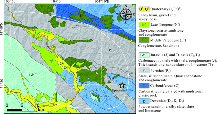
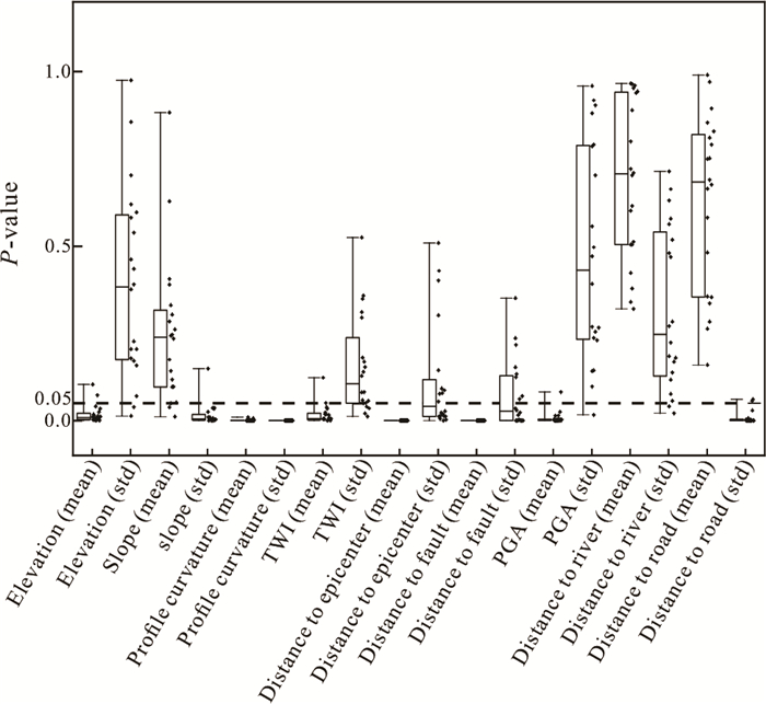
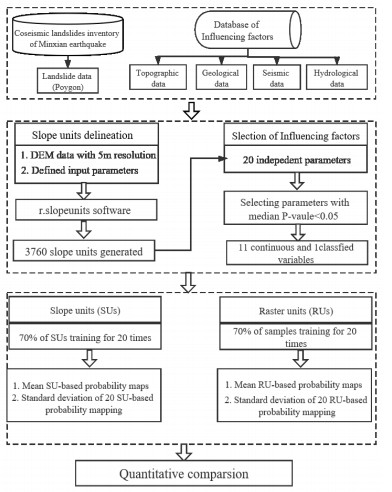
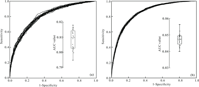
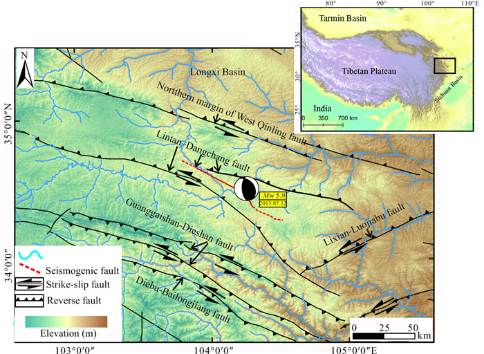
Choice of appropriate mapping units is important in landslide susceptibility mapping (LSM). There are various possible units for this choice, while it remains unclear which one is better in performance. The purpose of this study is to make a quantitative comparison of two commonly-used units: slope-unit (SU) and raster-unit (RU) based on the landslides triggered by the 2013 Minxian, Gansu, China

| Alvioli, M., Marchesini, I., Reichenbach, P., et al., 2016. Automatic Delineation of Geomorphological Slope Units with R. Slope Units V1.0 and Their Optimization for Landslide Susceptibility Modeling. Geoscientific Model Development, 9(11): 3975–3991. https://doi.org/10.5194/gmd-9-3975-2016 |
| Arnone, E., Francipane, A., Scarbaci, A., et al., 2016. Effect of Raster Resolution and Polygon-Conversion Algorithm on Landslide Susceptibility Mapping. Environmental Modelling & Software, 84: 467–481. https://doi.org/10.1016/j.envsoft.2016.07.016 |
| Bornaetxea, T., Rossi, M., Marchesini, I., et al., 2018. Effective Surveyed Area and Its Role in Statistical Landslide Susceptibility Assessments. Natural Hazards and Earth System Sciences, 18(9): 2455–2469. https://doi.org/10.5194/nhess-18-2455-2018 |
| Budimir, M. E. A., Atkinson, P. M., Lewis, H. G., 2015. A Systematic Review of Landslide Probability Mapping Using Logistic Regression. Landslides, 12(3): 419–436. https://doi.org/10.1007/s10346-014-0550-5 |
| Cama, M., Conoscenti, C., Lombardo, L., et al., 2016. Exploring Relationships between Grid Cell Size and Accuracy for Debris-Flow Susceptibility Models: A Test in the Giampilieri Catchment (Sicily, Italy). Environmental Earth Sciences, 75(3): 1–21. https://doi.org/10.1007/s12665-015-5047-6 |
| Cantarino, I., Carrion, M. A., Goerlich, F., et al., 2019. A ROC Analysis-Based Classification Method for Landslide Susceptibility Maps. Landslides, 16(2): 265–282. https://doi.org/10.1007/s10346-018-1063-4 |
| Conforti, M., Ietto, F., 2020. Influence of Tectonics and Morphometric Features on the Landslide Distribution: A Case Study from the Mesima Basin (Calabria, South Italy). Journal of Earth Science, 31(2): 393–409. https://doi.org/10.1007/s12583-019-1231-z |
| Dai, F. C., Lee, C. F., 2002. Landslide Characteristics and Slope Instability Modeling Using GIS, Lantau Island, Hong Kong. Geomorphology, 42(3/4): 213–228. https://doi.org/10.1016/s0169-555x(01)00087-3 |
| Dai, C., Li, W. L., Wang, D., et al., 2021. Active Landslide Detection Based on Sentinel-1 Data and InSAR Technology in Zhouqu County, Gansu Province, Northwest China. Journal of Earth Science, 32(5): 1092–1103. https://doi.org/10.1007/s12583-020-1380-0 |
| Deng, Q. D., 2007. Chinese Active Tectonic Map. Seismological Press, Beijing |
| Garcia, D., Mah, R. T., Johnson, K. L., et al., 2012. ShakeMap Atlas 2.0: An Improved Suite of Recent Historical Earthquake ShakeMaps for Global Hazard Analyses and Loss Model Calibration. The 15th World Conference on Earthquake Engineering: September 24–28, 2012, Lisbon |
| Guzzetti, F., Carrara, A., Cardinali, M., et al., 1999. Landslide Hazard Evaluation: A Review of Current Techniques and Their Application in a Multi-Scale Study, Central Italy. Geomorphology, 31(1/2/3/4): 181–216. https://doi.org/10.1016/s0169-555x(99)00078-1 |
| Guzzetti, F., Galli, M., Reichenbach, P., et al., 2006. Landslide Hazard Assessment in the Collazzone Area, Umbria, Central Italy. Natural Hazards and Earth System Sciences, 6(1): 115–131. https://doi.org/10.5194/nhess-6-115-2006 |
| He, X. L., Xu, C., Qi, W. W., et al., 2021. Landslides Triggered by the 2020 Qiaojia Mw 5.1 Earthquake, Yunnan, China: Distribution, Influence Factors and Tectonic Significance. Journal of Earth Science, 32(5): 1056–1068. https://doi.org/10.1007/s12583-021-1492-1 |
| Huang, Y. D., Xu, C., Zhang, X. L., et al., 2021. An Updated Database and Spatial Distribution of Landslides Triggered by the Milin, Tibet Mw 6.4 Earthquake of 18 November 2017. Journal of Earth Science, 32(5): 1069–1078. https://doi.org/10.1007/s12583-021-1433-z |
| Jacobs, L., Kervyn, M., Reichenbach, P., et al., 2020. Regional Susceptibility Assessments with Heterogeneous Landslide Information: Slope Unit- Vs. Pixel-Based Approach. Geomorphology, 356: 107084. https://doi.org/10.1016/j.geomorph.2020.107084 |
| Kargel, J. S., Leonard, G. J., Shugar, D. H., et al., 2016. Geomorphic and Geologic Controls of Geohazards Induced by Nepals 2015 Gorkha Earthquake. Science, 351(6269): aac8353. https://doi.org/10.1126/science.aac8353 |
| Kavzoglu, T., Kutlug Sahin, E., Colkesen, I., 2015. An Assessment of Multivariate and Bivariate Approaches in Landslide Susceptibility Mapping: A Case Study of Duzkoy District. Natural Hazards, 76(1): 471–496. https://doi.org/10.1007/s11069-014-1506-8 |
| Li, W. L., Huang, R. Q., Xu, Q., et al., 2013. Rapid Susceptibility Mapping of Co-Seismic Landslides Triggered by the 2013 Lushan Earthquake Using the Regression Model Developed for the 2008 Wenchuan Earthquake. Journal of Mountain Science, 10(5): 699–715. https://doi.org/10.1007/s11629-013-2786-2 |
| Ma, S. Y., Xu, C., 2019. Assessment of Co-Seismic Landslide Hazard Using the Newmark Model and Statistical Analyses: A Case Study of the 2013 Lushan, China, Mw 6.6 Earthquake. Natural Hazards, 96(1): 389–412. https://doi.org/10.1007/s11069-018-3548-9 |
| Ma, S. Y., Xu, C., Shao, X. Y., 2020. Spatial Prediction Strategy for Landslides Triggered by Large Earthquakes Oriented to Emergency Response, Mid-Term Resettlement and Later Reconstruction. International Journal of Disaster Risk Reduction, 43: 101362. https://doi.org/10.1016/j.ijdrr.2019.101362 |
| Massey, C., Townsend, D., Rathje, E., et al., 2018. Landslides Triggered by the 14 November 2016 Mw 7.8 Kaikōura Earthquake, New Zealand. Bulletin of the Seismological Society of America, 108(3B): 1630–1648. https://doi.org/10.1785/0120170305 |
| MATLAB, 2017. 9.7. 0.1190202 (R2017a). The MathWorks Inc, Natick |
| Molnar, P., Stock, J. M., 2009. Slowing of India's Convergence with Eurasia since 20 Ma and Its Implications for Tibetan Mantle Dynamics. Tectonics, 28(3): TC3001. https://doi.org/10.1029/2008tc002271 |
| Moore, I. D., Grayson, R. B., Ladson, A. R., 1991. Digital Terrain Modelling: A Review of Hydrological, Geomorphological, and Biological Applications. Hydrological Processes, 5(1): 3–30. https://doi.org/10.1002/hyp.3360050103 |
| Nowicki Jessee, M. A., Hamburger, M. W., Allstadt, K., et al., 2018. A Global Empirical Model for Near-Real-Time Assessment of Seismically Induced Landslides. Journal of Geophysical Research: Earth Surface, 123(8): 1835–1859. https://doi.org/10.1029/2017jf004494 |
| Reichenbach, P., Rossi, M., Malamud, B. D., et al., 2018. A Review of Statistically-Based Landslide Susceptibility Models. Earth-Science Reviews, 180: 60–91. https://doi.org/10.1016/j.earscirev.2018.03.001 |
| Roback, K., Clark, M. K., West, A. J., et al., 2018. The Size, Distribution, and Mobility of Landslides Caused by the 2015 Mw 7.8 Gorkha Earthquake, Nepal. Geomorphology, 301: 121–138. https://doi.org/10.1016/j.geomorph.2017.01.030 |
| Rossi, M., Guzzetti, F., Reichenbach, P., et al., 2010. Optimal Landslide Susceptibility Zonation Based on Multiple Forecasts. Geomorphology, 114(3): 129–142. https://doi.org/10.1016/j.geomorph.2009.06.020 |
| Rossi, M., Reichenbach, P., 2016. LAND-SE: A Software for Statistically Based Landslide Susceptibility Zonation, Version 1.0. Geoscientific Model Development, 9(10): 3533–3543. https://doi.org/10.5194/gmd-9-3533-2016 |
| Schlögel, R., Marchesini, I., Alvioli, M., et al., 2018. Optimizing Landslide Susceptibility Zonation: Effects of DEM Spatial Resolution and Slope Unit Delineation on Logistic Regression Models. Geomorphology, 301: 10–20. https://doi.org/10.1016/j.geomorph.2017.10.018 |
| Shao, X. Y., Ma, S. Y., Xu, C., et al., 2019. Planet Image-Based Inventorying and Machine Learning-Based Susceptibility Mapping for the Landslides Triggered by the 2018 Mw 6.6 Tomakomai, Japan Earthquake. Remote Sensing, 11(8): 978. https://doi.org/10.3390/rs11080978 |
| Shao, X. Y., Ma, S. Y., Xu, C., et al., 2020a. Effects of Raster Resolution on Real Probability of Landslides. Remote Sensing Applications: Society and Environment, 19: 100364. https://doi.org/10.1016/j.rsase.2020.100364 |
| Shao, X. Y., Ma, S. Y., Xu, C., et al., 2020b. Effects of Sampling Intensity and Non-Slide/Slide Sample Ratio on the Occurrence Probability of Coseismic Landslides. Geomorphology, 363: 107222. https://doi.org/10.1016/j.geomorph.2020.107222 |
| Shirzadi, A., Solaimani, K., Roshan, M. H., et al., 2019. Uncertainties of Prediction Accuracy in Shallow Landslide Modeling: Sample Size and Raster Resolution. Catena, 178: 172–188. https://doi.org/10.1016/j.catena.2019.03.017 |
| Sun, X. H., Chen, J. P., Han, X. D., et al., 2020. Application of a GIS-Based Slope Unit Method for Landslide Susceptibility Mapping along the Rapidly Uplifting Section of the Upper Jinsha River, South-Western China. Bulletin of Engineering Geology and the Environment, 79(1): 533–549. https://doi.org/10.1007/s10064-019-01572-5 |
| Swets, J. A., 1988. Measuring the Accuracy of Diagnostic Systems. Science, 240(4857): 1285–1293. https://doi.org/10.1126/science.3287615 |
| Tanyas, H., Rossi, M., Alvioli, M., et al., 2019. A Global Slope Unit-Based Method for the Near Real-Time Prediction of Earthquake-Induced Landslides. Geomorphology, 327: 126–146. https://doi.org/10.1016/j.geomorph.2018.10.022 |
| Tapponnier, P., 2001. Oblique Stepwise Rise and Growth of the Tibet Plateau. Science, 294(5547): 1671–1677. https://doi.org/10.1126/science.105978 |
| Tian, Y. Y., Xu, C., Hong, H. Y., et al., 2019. Mapping Earthquake-Triggered Landslide Susceptibility by Use of Artificial Neural Network (ANN) Models: An Example of the 2013 Minxian (China) Mw 5.9 Event. Geomatics, Natural Hazards and Risk, 10(1): 1–25. https://doi.org/10.1080/19475705.2018.1487471 |
| Tian, Y. Y., Xu, C., Ma, S. Y., et al., 2019. Inventory and Spatial Distribution of Landslides Triggered by the 8th August 2017 Mw 6.5 Jiuzhaigou Earthquake, China. Journal of Earth Science, 30(1): 206–217. https://doi.org/10.1007/s12583-018-0869-2 |
| Tian, Y. Y., Xu, C., Xu, X. W., et al., 2016. Detailed Inventory Mapping and Spatial Analyses to Landslides Induced by the 2013 Ms 6.6 Minxian Earthquake of China. Journal of Earth Science, 27(6): 1016–1026. https://doi.org/10.1007/s12583-016-0905-z |
| van den Eeckhaut, M., Reichenbach, P., Guzzetti, F., et al., 2009. Combined Landslide Inventory and Susceptibility Assessment Based on Different Mapping Units: An Example from the Flemish Ardennes, Belgium. Natural Hazards and Earth System Sciences, 9(2): 507–521. https://doi.org/10.5194/nhess-9-507-2009 |
| Xu, C., Xu, X. W., Dai, F. C., et al., 2013. Application of an Incomplete Landslide Inventory, Logistic Regression Model and Its Validation for Landslide Susceptibility Mapping Related to the May 12, 2008 Wenchuan Earthquake of China. Natural Hazards, 68(2): 883–900. https://doi.org/10.1007/s11069-013-0661-7 |
| Xu, C., Xu, X. W., Shyu, J. B. H., 2015. Database and Spatial Distribution of Landslides Triggered by the Lushan, China Mw 6.6 Earthquake of 20 April 2013. Geomorphology, 248: 77–92. https://doi.org/10.1016/j.geomorph.2015.07.002 |
| Xu, C., Xu, X. W., Shyu, J. B. H., et al., 2014. Landslides Triggered by the 22 July 2013 Minxian-Zhangxian, China, Mw 5.9 Earthquake: Inventory Compiling and Spatial Distribution Analysis. Journal of Asian Earth Sciences, 92: 125–142. https://doi.org/10.1016/j.jseaes.2014.06.014 |
| Xu, C., Xu, X. W., Tian, Y. Y., et al., 2016. Two Comparable Earthquakes Produced Greatly Different Coseismic Landslides: The 2015 Gorkha, Nepal and 2008 Wenchuan, China Events. Journal of Earth Science, 27(6): 1008–1015. https://doi.org/10.1007/s12583-016-0684-6 |
| Yin, Y. P., Wang, F. W., Sun, P., 2009. Landslide Hazards Triggered by the 2008 Wenchuan Earthquake, Sichuan, China. Landslides, 6(2): 139–152. https://doi.org/10.1007/s10346-009-0148-5 |
| Zheng, W. J., Yuan, D. Y., He, W. G., et al., 2013. Geometric Pattern and Active Tectonics in Southeastern Gansu Province: Discussion on Seismogenic Mechanism of the Minxian-Zhangxian Ms 6.6 Earthquake on July 22, 2013. Chinese Journal of Geophysics, 56(12): 4058–4071 (in Chinese with English Abstract) |
Figures(13)
Copyright © 2013-2020 Journal of Earth Science 鄂ICP备15021562号-2
Tel: +86-27-67885075 Fax: +86-27-67885075 E-mail: xbb@cug.edu.cn
Address: Editorial Office of Journal, China University of Geosciences, Yujiashan, Wuhan, Hubei 430074, P. R. China
Supported by:
Beijing Renhe Information Technology Co. Ltd
E-mail:
info@rhhz.net


 DownLoad: