Advanced Search

Indexed by SCI、CA、РЖ、PA、CSA、ZR、etc .

2023 Vol. 34, No. 2

Display Method:
COVER
2023, 34(2): .
Abstract:
CONTENTS
2023, 34(2): .
Abstract:
Special Column on Geo-Disasters
Guest Editors: Chong Xu, Xiwei Xu, and Yu Huang
Twin Earthquakes Devastate Southeast Türkiye and Syria: First Report from the Epicenters
Timothy M. Kusky, Erdin Bozkurt, Jiannan Meng, Lu Wang
2023, 34(2): 291-296. doi: 10.1007/s12583-023-1317-5
Abstract:
Early Report of the Source Characteristics, Ground Motions, and Casualty Estimates of the 2023 Mw 7.8 and 7.5 Turkey Earthquakes
Wenkai Chen, Gang Rao, Dengjie Kang, Zhifan Wan, Dun Wang
2023, 34(2): 297-303. doi: 10.1007/s12583-023-1316-6
Abstract:
Crown-Like Baffle System against Rock Avalanches: Energy Dissipation Mechanism and Numerical Verification
Yu Huang, Hao Shi, Bei Zhang
2023, 34(2): 304-315. doi: 10.1007/s12583-021-1571-3
Abstract:

In mountainous areas, rock avalanches swarm downslope leading to large impact forces on structures. Baffle systems are usually set up in torrent channels to dissipate the flow energy and reduce the destructive effects. In this paper, a crown-like baffle system is proposed to better dissipate the flow energy. The energy dissipation mechanism of this system was investigated based on DEM. The results reveal more than 90% of the kinetic energy of the granular flow was dissipated by particle-particle interaction. Two effects, the impedance effect and the deflection effect, were identified. The influence of these effects leads to the formation and growth of cushions behind the baffles, and these cushions enhance the particle-particle interaction. Two crown-like baffle systems were compared with a conventional baffle system based on the typical avalanche model. The results reveal the cumulative residual kinetic energy of the crown-like baffle system with square baffles decreased by 18.75% with the same concrete consumption as the conventional baffle system. For the crown-like baffle system with triangular baffles, the cumulative residual kinetic energy decreased by 6.22% with 83.94% of the concrete consumption of the conventional baffle system. Hence, the proposed baffle system is more cost-effective compared with the conventional baffle system.

A Comparative Study of Supervised Classification Methods for Investigating Landslide Evolution in the Mianyuan River Basin, China
Yujie Long, Weile Li, Runqiu Huang, Qiang Xu, Bin Yu, Gang Liu
2023, 34(2): 316-329. doi: 10.1007/s12583-021-1525-9
Abstract:

The Ms 8.0 Wenchuan earthquake of 2008 dramatically changed the terrain surface and caused long-term increases in the scale and frequency of landslides and debris flows. The changing trend of landslides in the earthquake-affected area over the decade since the earthquake remains largely unknown. In this study, we were able to address this issue using supervised classification methods and multitemporal remote sensing images to study landslide evolution in the worst-affected area(Mianyuan River Basin) over a period of ten years. Satellite images were processed using the maximum likelihood method and random forest algorithm to automatically map landslide occurrence from 2007 to 2018. The principal findings are as follows: (1) when compared with visual image analysis, the random forest algorithm had a good average accuracy rate of 87% for landslide identification; (2) postevent landslide occurrence has generally decreased with time, but heavy monsoonal seasons have caused temporary spikes in activity; and (3) the postearthquake landslide activity in the Mianyuan River Basin can be divided into a strong activity period (2008 to 2011), medium activity period (2012 to 2016), and weak activity period (post 2017). Landslide activity remains above the prequake level, with damaging events being rare but continuing to occur. Long-term remote sensing and on-site monitoring are required to understand the evolution of landslide activity after strong earthquakes.

Joint Effects and Spatiotemporal Characteristics of the Driving Factors of Landslides in Earthquake Areas
Jintao Yang, Chong Xu, Xu Jin
2023, 34(2): 330-338. doi: 10.1007/s12583-021-1465-4
Abstract:

Understanding the joint effects of earthquakes and driving factors on the spatial distribution of landslides is helpful for targeted disaster prevention and mitigation in earthquake-prone areas. By far, little work has been done on this issue. This study analyzed the co-seismic landslide of the Ms 8.0 Wenchuan earthquake in 2008 and 2014. The joint effects and spatiotemporal characteristics of the driving factors in seismic regions were revealed. Results show that (a) between 2008 and 2014, the dominant driving-factor for landslides has changed from earthquake to rock mass; (b) driving factors with weak driving force have a significant enhancement under the joint effects of other factors; (c) the joint effects of driving factors and earthquake decays with time. The study concluded that the strong vibration of the Wenchuan earthquake and the rock mass strength are the biggest contributors to the spatial distribution of landslides in 2008 and 2014, respectively. It means that the driving force of the earthquake is weaker than that of the rock mass after six years of the Wenchuan earthquake. Moreover, the landslide spatial distribution can be attributed to the joint effects of the Wenchuan earthquake and driving factors, and the earthquake has an enhanced effect on other factors.

Numerical Simulation of Liquefaction-Induced Settlement of Existing Structures
Wuwei Mao, Wei Li, Rouzbeh Rasouli, Naveed Ahmad, Hu Zheng, Yu Huang
2023, 34(2): 339-346. doi: 10.1007/s12583-021-1531-y
Abstract:

This study presents a numerical approach for assessment of the structure settlement problems in liquefied soils. The fluid dynamics theory was applied to model the liquefied soils and the rigid body dynamics theory was applied to compute the structure's translational and angular motions in six degrees of freedom. The dynamic mesh method was applied to modify the deformed mesh due to structure settlement. Shaking table tests were carried out to reproduce the structure's subsidence behavior and provide validation for the numerical simulations. Results show that the settlement of the structure occurred most rapidly at the very beginning of liquefaction, and then it decreased gradually. Main structure settlements occurred within 10 s after liquefaction. Regarding different structure weights, structure with larger weight yielded larger amount of settlement and higher peak settlement velocity. The results obtained in this study are beneficial for assessment of structure settlement problems in liquefaction prone areas.

Rate-Dependent Weakening of the Shear Force for the Submerged Granular Medium Based on the Experimental Study
Hu Zheng, Guowei Dai, Wuwei Mao, Yu Huang
2023, 34(2): 347-353. doi: 10.1007/s12583-021-1541-9
Abstract:

An experimental study is conducted to describe rate-dependent shear strength in a submerged granular medium to understand the mystery of submarine landslides with extremely small slide angles and long run-out distances. The experimental apparatus allows a long-span shear strain rate, $ \dot{\mathit{\gamma }} $, for five orders of magnitude from 10-4 to 101 s-1. It is observed that (a) submerged sand under higher shear tend to have bigger yield strength; this positive response of rate effect is significantly affected by the magnitudes of shear strain rates. (b) the residual strength of soil is clearly affected negatively by shear strain rate, decreasing as shear strain rate increases; even small variations under lower rate cause notable differences in residual strength, indicating a novel weaking rate-dependent. The yield strength and residual strength are corresponding to the shear state of soil. Hence, it is enough experimentally to explain that as long as the submarine mass flow speeds up, the slope sliding can be kept by only a small amount of force along the slide direction, which can be calculated as the gravity component even with a small slide angle.

Mechanical Behaviors of Anchorage Interfaces in Layered Rocks with Fractures under Axial Loads
Yan Wang, Changdong Li, Zhilan Cai, Guoqiang Zhu, Jiaqing Zhou, Wenmin Yao
2023, 34(2): 354-368. doi: 10.1007/s12583-022-1785-z
Abstract:

Rock bolts are widely employed as an effective and efficient reinforcement method in geotechnical engineering. Sandwich composite structures formed by hard rock and weak rock are often encountered in practical projects. Furthermore, the spatial structure of the rock mass has a direct influence on the effect of the anchorage support. To investigate the impact of rock mass structure on the mechanical characteristics of anchorage interfaces, pull-out tests on reinforced specimens with different mudstone thicknesses and fracture dip angles are conducted. The experimental results indicate that the percentage of mudstone content and fracture dip angle have a significant influence on the pullout load of the samples. A weaker surrounding rock results in a lower peak load and a longer critical anchorage length, and vice versa. The results also show that 70% mudstone content can be considered a critical condition for impacting the peak load. Specifically, the percentage of mudstone content has a limited influence on the variation in the peak load when it exceeds 70%. Optical fiber deformation results show that compared to the rock mass with fracture dip angles of 0° and 60°, the rock mass with a fracture dip angle of 30° has a more uniformly distributed force at the anchorage interface. When the fracture dip angle exceeds 60°, the dip angle is no longer a key indicator of peak load. The accuracy of the experimentally obtained load-displacement curves is further verified although numerical simulation using the discrete element method.

Qualitative Analyses of Correlations between Strong Ground Motions of the Three Large Earthquakes and Landslide Distributions
Yuzhu Bai, Chong Xu
2023, 34(2): 369-380. doi: 10.1007/s12583-021-1496-x
Abstract:

In this work, the correlations between spatial distributions of landslide point density (LPD) and strong ground motions of the three strong earthquakes are qualitatively investigated. Meanwhile the qualitative relationship between the distribution of LPD and the fault rupture process is also characterized. Three strong events are the Lushan, Wenchuan, and Jiuzhaigou earthquakes. In order to reconstruct the near filed strong ground motions and the fault processes of these earthquakes, the broadband ground simulation method of University of California Santa Barbara (UCSB) and the simplified crustal layer structures are applied. To show the rationality of the UCSB method, the fault slip distributions of the three earthquakes reconstructed by the kinematic rupture generator model in the UCSB method are compared with those by inversed. Furthermore, the validation of the UCSB method for the three earthquakes is also carried according to the validation exercise of the Southern California Earthquake Center (SCEC) Broadband Platform (BBP). Lastly, the fields of peak ground acceleration (PGA) and peak ground velocity (PGV) in three mutually perpendicular directions of the three earthquakes are achieved. Generally, the landslide distribution length of large LPD values along the fault strike is less than the fault strike length. Therefore, the slip modes of earthquake faults affect the distributions of landslides. For the strike slip earthquakes, the distributions of large LPD values relate well to PGA and PGV components of the parallel and normal to the fault strike. For the reverse slip earthquakes, distributions of LPD relate to ground motion components in all directions. Moreover, distributions of landslides in near fields of earthquakes are significantly affected by the focus parameters and fault scales.

Model Tests on the Effect of Dip Angles on Flow Behavior of Liquefied Sand
Wenyang Li, Yu Huang
2023, 34(2): 381-385. doi: 10.1007/s12583-021-1498-8
Abstract:

The flow behavior of liquefied sand is reported using a self-developed testing system that enables the flow processes of liquefied sand to be studied at different slopes of the soil layers. The test device is mainly composed of a vibrating table, a transparent model box and a high-speed video monitoring camera. The tests replicated the horizontal and sloping flows of saturated sand in the model box, which can be tilted to various angles to study the flow characteristics of liquefied sand. The high-speed video monitoring camera captured and recorded the processes within the flowing sand. With increasing downslope, the strain, strain rate, duration time, and sand flow distance increased. The results of our experiment indicate that when selecting sites for engineering structures, the surface downslopes should be taken into account if liquefiable soils are present. Finally, some suggestions regarding site assessment and structural design for sites prone to liquefaction were presented.

Landslide Susceptibility Mapping in Terms of the Slope-Unit or Raster-Unit, Which is Better?
Siyuan Ma, Xiaoyi Shao, Chong Xu
2023, 34(2): 386-397. doi: 10.1007/s12583-021-1407-1
Abstract:

Choice of appropriate mapping units is important in landslide susceptibility mapping (LSM). There are various possible units for this choice, while it remains unclear which one is better in performance. The purpose of this study is to make a quantitative comparison of two commonly-used units: slope-unit (SU) and raster-unit (RU) based on the landslides triggered by the 2013 Minxian, Gansu, China Mw 5.9 earthquake. Ten landslide influencing factors were considered in this analysis. For each type of mapping units, the 70% samples were randomly selected and trained 20 times on the LR model, yielding 20 susceptibility maps, and the remaining 30% samples were tested for the accuracy of the modeling outcome. Different metrics, including the mean probability, model uncertainty, and model prediction skills, were used to evaluate the quality of the susceptibility maps. The results show that the resultant probability maps using two mapping units can largely predict the distribution of actual landslides, on which the high susceptibility area corresponds to the landslide-prone area. The AUC (area under curve) values, ranging from 0.8 to 0.86, show that the prediction ability of two mapping units is roughly the same. While comparing with the RU, the use of SU can lower the model uncertainties caused by the variation of training sets. We converted the RU-based assessment results into SU-based scheme. The results show that two assessment results are well fitted with good linear relationship, which implies that it is feasible to convert the RU-based landslide susceptibility mapping into the SU-based scheme. This analysis indicates that compared with the RU, the SU cannot improve the performance and accuracy of seismic landslide susceptibility mapping.

A Diverse Microfossil Assemblage from the Ediacaran–Cambrian Deep-Water Chert of the Liuchapo Formation in Guizhou Province, South China
Yan Zhang, Shan Chang, Qinglai Feng, Shucan Zheng
2023, 34(2): 398-408. doi: 10.1007/s12583-021-1485-0
Abstract:

The Ediacaran to Cambrian transition witnessed great biological and environmental turnovers from the Precambrian to Phanerozoic. These changes are also reflected by the fossil records during that time. However, the fossil distribution was highly heterogenous. While diverse fossils were constantly found from the shallow shelf including restricted basins, reports from deep-water areas, which are characterized by chert-dominated formations straddling the Ediacaran-Cambrian boundary, were scarce. Among them was the Liuchapo Formation that has been considered barren. In this study, a fossiliferous assemblage was found from the Liuchapo Formation in east Guizhou Province, South China. This assemblage comprises Palaeopascichnus jiumenensis, Horodyskia minor, multicellular algae that possibly related with red algae, cyanobacteria, sponge spicules, small shelly fossils, membrane structures of uncertain affinity, and fossils with structures resemble the Ediacaran Megasphaera. Palaeopascichnus and Horodyskia have been widely reported and abundant in the Liuchapo Formation and equivalents, while the others have seldomly, or never, been found from this formation or, more widely, the deep-water chert of transitional interval. The discovery not only contributes to the rare paleontological records preserved in deep-water sediments, but also expanded the geographic distribution of the fossils, providing new materials of biological diversity during this critical interval.

Strain Localized Deformation Variation of a Small-Scale Ductile Shear Zone
Lefan Zhan, Shuyun Cao, Yanlong Dong, Wenyuan Li
2023, 34(2): 409-430. doi: 10.1007/s12583-022-1681-6
Abstract:

A continental-scale strike-slip shear zone frequently presents a long-lasting deformation and physical expression of strain localization in a middle to lower crustal level. However, the deformation evolution of strain localization at a small-scale remains unclear. This study investigated < 10 cm wide shear zones developing in undeformed granodiorites exposed at the boundary of the continental-scale Gaoligong strike-slip shear zone. The small-scale ductile shear zones exhibit a typical transition from protomylonite, mylonite to extremely deformed ultramylonite, and decreasing mineral size from coarse-grained aggregates to extremely fine-grained mixed phases. Shearing sense indicators such as hornblende and feldspar porphyroclasts in the shear zone are the more significantly low-strain zone of mylonite. The microstructure and EBSD results revealed that the small-scale shear zone experienced ductile deformation under medium-high temperature conditions. Quartz aggregates suggested a consistent temperature with an irregular feature, exhibiting a dominated high-temperature prism < a > slip system. Additionally, coarse-grained aggregates in the mylonite of the shear zone were deformed predominantly by dislocation creep, while ultra-plastic flow by viscous grain boundary sliding was an essential deformation process in the extremely fine-grained (~50 μm) mixed-phases in the ultramylonite. Microstructural-derived strain rates calculated from quartz paleopiezometry were on the order of 10-15 to 10-13 s-1 from low-strain mylonite to high strained ultramylonite. The localization and strain rate-limited process was fluid-assisted precipitation presenting transitions of compositions as hydrous retrogression of hornblende to mica during increasing deformation and exhumation. Furthermore, the potential occurrence of the small-scale shear zone was initiated at a middle-deep crust seated crustal condition dominated by the temperature-controlled formation and rheological weakening.

Petrogenesis and Tectonic Implications of the Late Silurian–Early Devonian Bimodal Intrusive Rocks in the Central Beishan Orogenic Belt, NW China: Constraints by Petrology, Geochemistry and Hf Isotope
Jian Tian, Hou-Tian Xin, Xue-Jian Teng, Min Li, Qun-An Liao, Yong Zhang, Bang-Fang Ren
2023, 34(2): 431-443. doi: 10.1007/s12583-020-1078-3
Abstract:

A large number of Late Silurian–Early Devonian intrusive rocks are distributed in the central Beishan orogenic belt (BOB). Tectonic setting of these intrusive rocks is of great significance to the study of the subduction and accretion of the Paleo-Asian Ocean. Previous studies show that most of the intrusive rocks in this region are S-type or A-type granitoids. In this study, we firstly reported the Late Silurian–Early Devoniandia bases, granodiorites on the southside of the Baiyunshan ophiolitic mélanges belt, as a part of Hongliuhe-Xichangjing ophiolitic mélanges belt (HXOMB). Zircon LA-ICP-MS U-Pb dating yields emplacement ages between 418 and 397 Ma, REE distribution patterns exhibit enriched LREE and flat HREE in the diabases, the discriminant diagrams show that the diabases have geochemical characteristics of intraplate basalt. The granodiorites in this paper present more like S- and A-type granitoids reported, showing the geochemical characteristics of syn/post-collision granites. Actually, the bimodal magmatic rocks are developed during Late Silurian–Early Devonian on both sides of the HXOMB, which are related to the tectonic background of the post orogeny extension. The diabases are tholeiitic with relative strong depleted εHf(t) (+8.1 to +13.0), which are mainly from relative depleted mantle. The granodiorites are calc-alkaline with relative slightly depleted εHf(t) (+0.7 to +5.6) and the lower Mg# and MgO contents (34.6–36.9, 0.50 wt.%–1.19 wt.% respectively), reflecting the source characteristics of meta-basalt. Therefore, the remelting of juvenile crust may be the main way of continental crust accretion during Late Silurian–Early Devonian in the central BOB.

Petrology, Zircon Chronology and Geochemistry of the Late Silurian Ophiolitic Mélanges and the Baiyunshan Forearc Complex in the Central Beishan Orogenic Belt, NE China
Hou-Tian Xin, Jian Tian, Xue-Jian Teng, Li-Xin Sun, Guo-Zhen Zhang, Yong Zhang, Bang-Fang Ren
2023, 34(2): 444-455. doi: 10.1007/s12583-020-1377-8
Abstract:

The WNW-ESE-trending Baiyunshan ophiolitic mélange is exposed in the central Beishan orogenic belt (BOB), between the Hongliuhe-Niujuanzi and Xichangjing ophiolitic mélanges in the west and east, respectively. Here we present new petrological, geochemical, and zircon U-Pb age data for the Baiyunshan ophiolitic mélange and metamorphosed lithic sandstones of "the Baiyunshan Formation". The Baiyunshan ophiolitic mélange is characterized by a block-in-matrix structure, and the blocks of ultramafic-mafic rocks are mainly pyroxenites, dunites, gabbros, and minor hornblendites. Zircon U-Pb dating yielded an emplacement age of 424.2 ± 3.7 Ma for the gabbros. The ultramaficmafic rocks have geochemical features of supra-subduction zone-type ophiolites, including low Ti contents (TiO2 = 0.01 wt.%–0.35 wt.%), negative Nb-Ta anomalies, and U-shaped rare earth element patterns with positive Eu anomalies (δEu = 0.99–3.25). "The Baiyunshan Formation" is exposed to the north of the ophiolitic mélange, and comprises mainly meta-cherts in its lower part and metasandstones and marbles in its upper part. Blocks of basalt are locally dispersed in the sand-slate matrix. The ages of detrital zircons in the metamorphosed lithic sandstones range from 521 to 464 Ma, with an age peak of 500 Ma, which is similar to those of the Gongpoquan arc in the north. The central Beishan orogenic belt experienced continuous subduction of the Hongliuhe-Xichangjing oceanic lithosphere in the Late Silurian, which produced the Baiyunshan forearc complex and supra-subduction zone-type ophiolite.

Precipitation of High Mg-Calcite and Protodolomite Using Dead Biomass of Aerobic Halophilic Bacteria
Qigao Fan, Deng Liu, Dominic Papineau, Xuan Qiu, Hongmei Wang, Zhenbing She, Linduo Zhao
2023, 34(2): 456-466. doi: 10.1007/s12583-020-1108-1
Abstract:

The microbial dolomite model has been used to interpret the origin of sedimentary dolomite. In this model, the formation of low-temperature protodolomite, an important precursor to sedimentary dolomite, can be facilitated either by actively metabolizing cells of anaerobic microbes and aerobic halophilic archaea or by their inactive biomass. Aerobic halophilic bacteria are widely distri-buted in (proto-)dolomite-depositing evaporitic environments and their biomass might serve as a template for the crystallization of protodolomite. To test this hypothesis, carbonation experiments were conducted using dead biomass of an aerobic halophilic bacterium (Exiguobacterium sp. strain JBHLT-3). Our results show that dead biomass of JBHLT-3 can accelerate Mg2+ uptake in carbonate mineral precipitates. In addition, the amount of Mg incorporated into Ca-Mg carbonates is proportional to the concentration of biomass. High Mg-calcite is produced with 0.25 or 0.5 g/L biomass, whereas protodolomite forms with 1 g/L biomass. This is confirmed by the main Raman peak of Ca-Mg carbonates, which shifts towards higher wavenumbers with increased Mg substitution. Microbial cells and their imprints are preserved on the surface of high Mg-calcite and protodolomite. Hence, this study furthers our understanding of the dolomitization within buried and dead microbial mats, which provides useful insights into the origin of ancient dolomite.

Origin of Qushenla Formation Volcanic Rocks in the Nawucuo Area, Northern Tibet, and Constraints on the Subduction Polarity of the Bangong-Nujiang Tethys Ocean
Chuanyang Lei, Liqiang Wang, Juxing Tang, Wei Li, Teng Gao, Huayun Yuan
2023, 34(2): 467-486. doi: 10.1007/s12583-020-1076-5
Abstract:

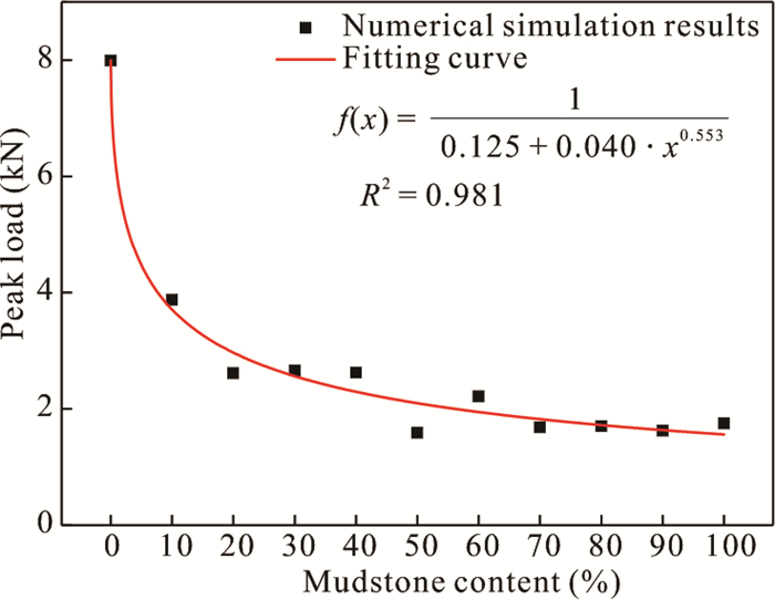
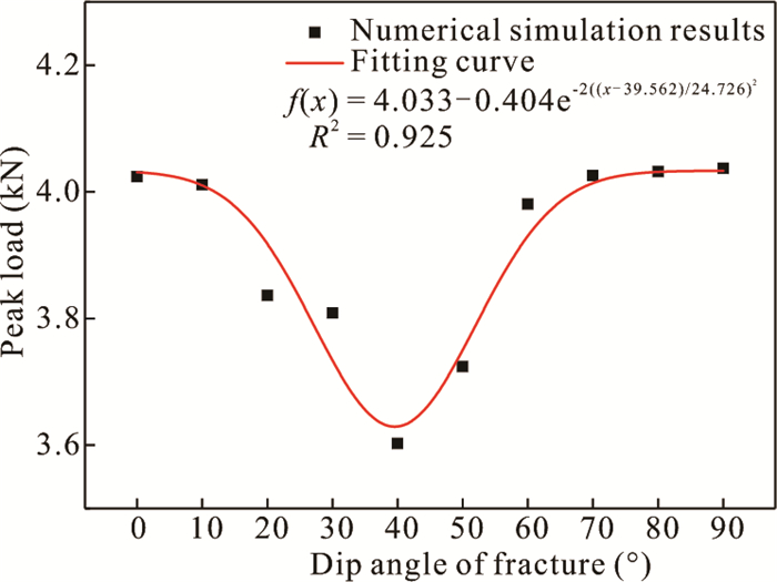
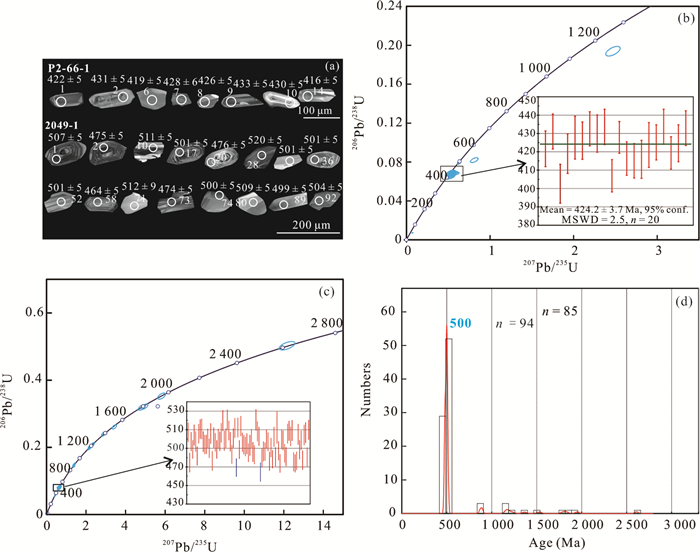
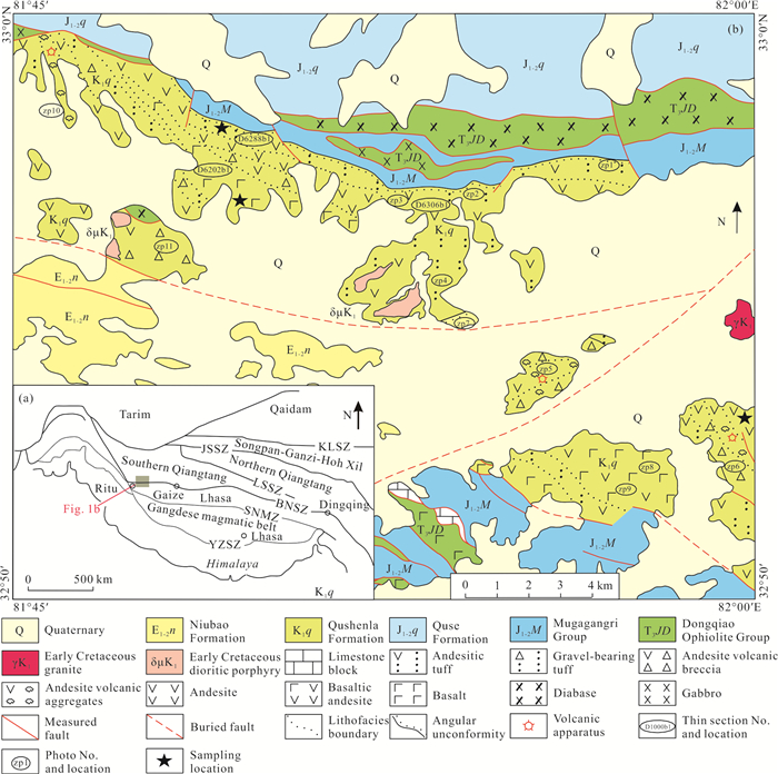
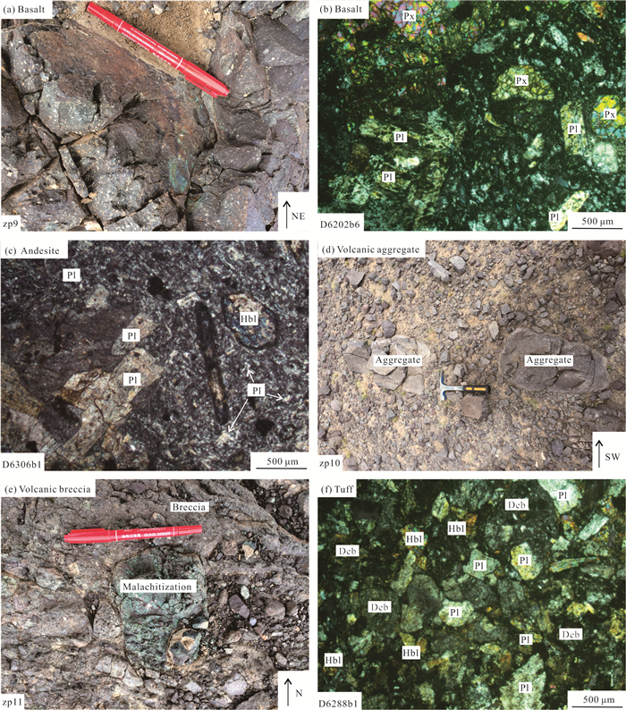
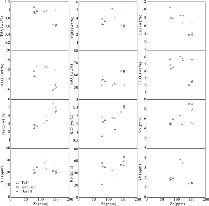
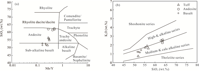
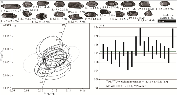
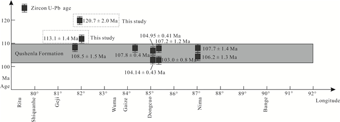
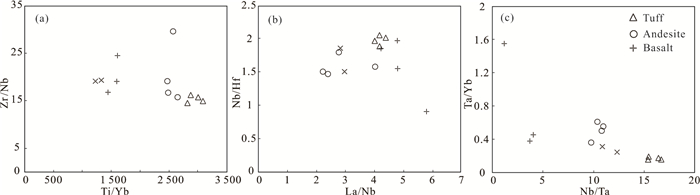
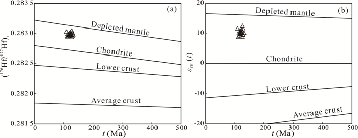
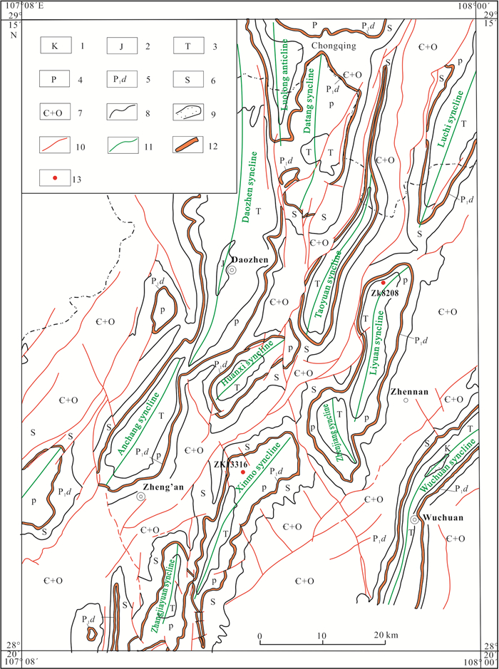
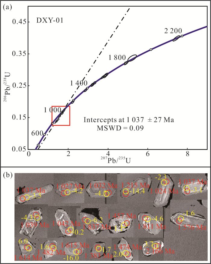
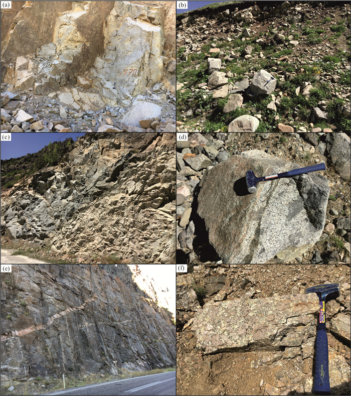
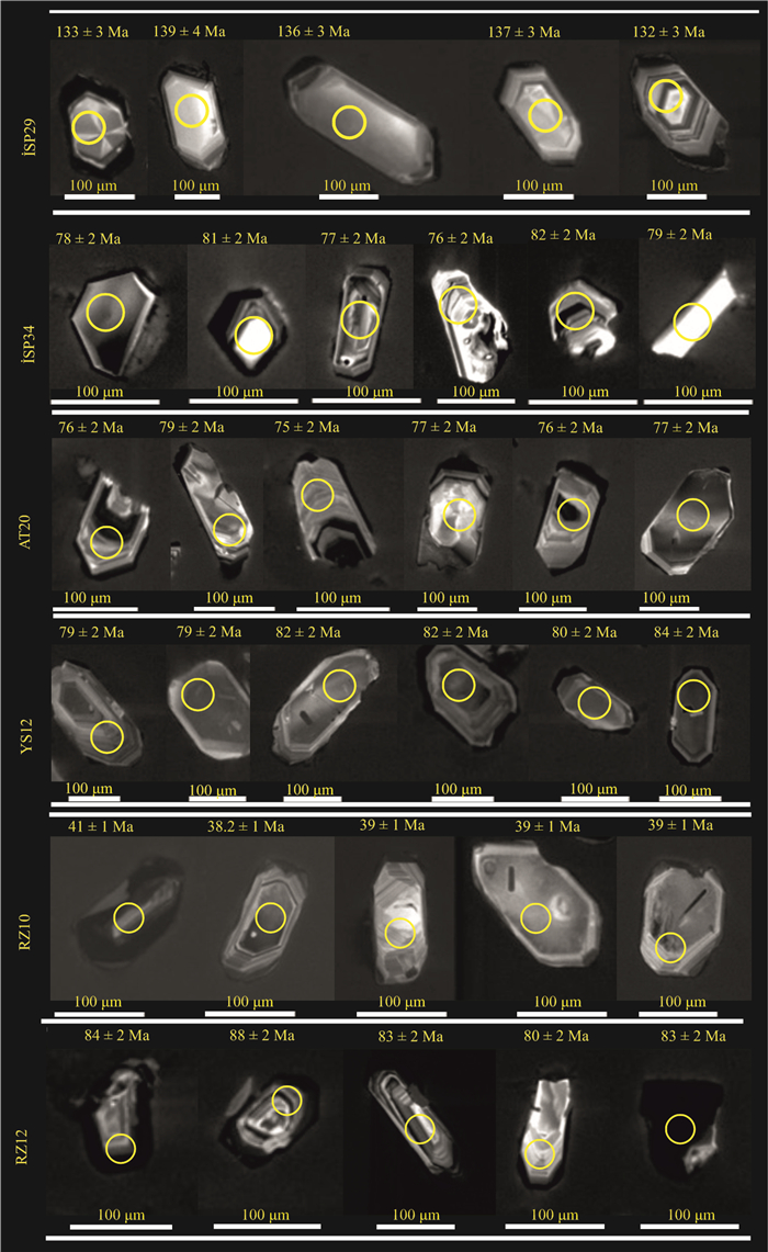
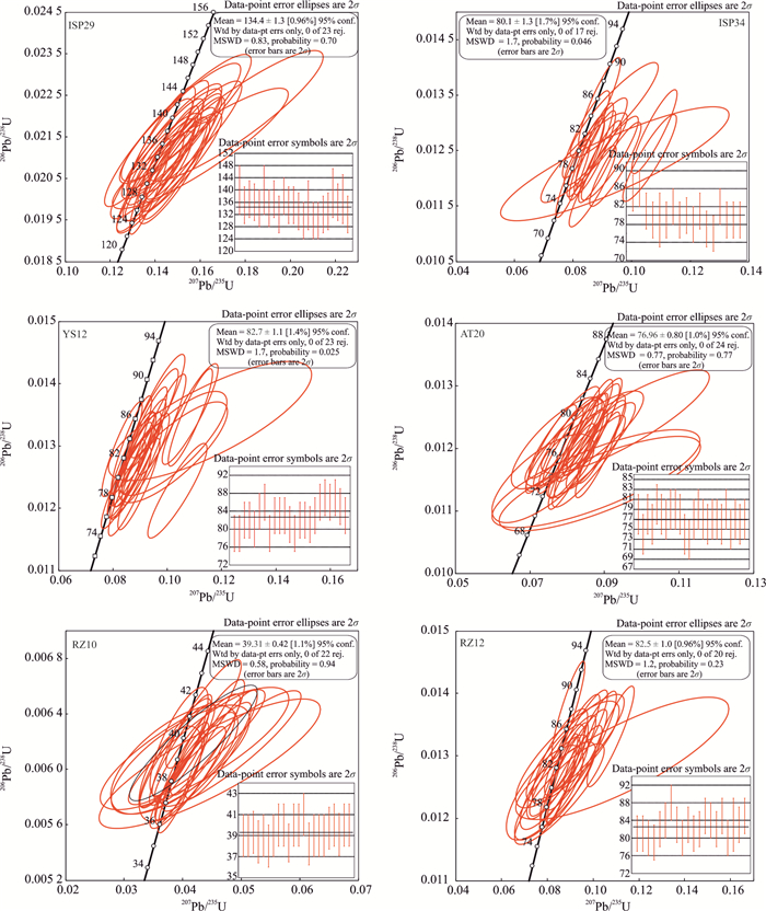
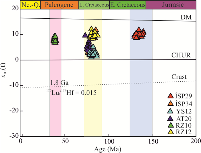
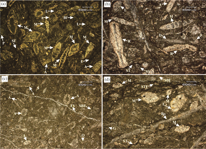
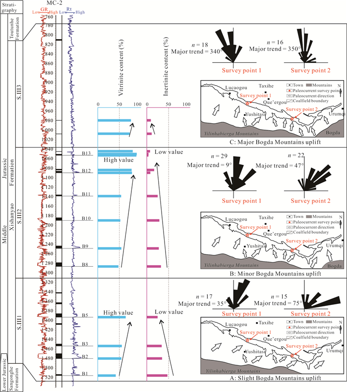
The Qushenla Formation volcanic rocks are widely exposed in the northern margin of the Bangong-Nujiang suture zone (BNSZ). Research on these rocks is of great significance for understanding the tectonic evolution of the Bangong-Nujiang Tethys Ocean (BNTO). In this study, a systematic geological survey was conducted on the Qushenla Formation volcanic rocks that are widely exposed in the Nawucuo area, in the northern margin of the western segment along the BNSZ. The whole-rock geochemistry, zircon U-Pb dating, and in situ zircon Lu-Hf isotopes were carried out in this study, aiming to constrain the formation age, rock genesis, magma source and tectonic setting of the volcanic rocks. The zircon U-Pb dating shows that the Qushenla Formation volcanic rocks in the western BNSZ erupted during the period of 120–108 Ma, i.e., Early Cretaceous. The Qushenla Formation volcanic rocks are a suite of intermediate-basic volcanic and pyroclastic rocks belonging to the medium-K calc-alkaline series. They are relatively enriched in light rare earth elements (LREEs) and incompatible elements such as Rb, K, La, Th, Sm, and Hf, whereas depleted in heavy REEs (HREEs) and high field strength elements (HFSEs) such as Nb, P, Zr, and Ti. The in situ zircon εHf(t) values of the volcanic rocks range from 8.95 to 12.57, with an average of 10.40. The Mg#, Th/La and Th/Ce values are between those of the mantle-derived magma and the continental crust. The formation of the Qushenla Formation volcanic rocks can be explained through the following process: (1) As the nospheric materials that upwelled during the rollback of the subducting Tethys Ocean slab induced the large-scale partial melting of the mantle wedge and the formation of the initial basaltic magma. (2) These mantle-derived magmas ascended and induced the partial melting of the lower crust to generate peraluminous melts. (3) The mixing of the peraluminous melts and mantle-derived melts generated the initial magma with homogeneous Sr-Nd isotope compositions. (4) Last, the eruption of the magma produced the widespread Qushenla Formation volcanic rocks at the surface. When combining this information with the regional geological background, it is believed that the Qushenla Formation volcanic rocks, the Meiriqicuo Formation volcanic rocks and the Late Jurassic–Early Cretaceous intrusive rocks together constitute the tectonic magmatic arc of the active continental margin on the southern margin of Qiangtang, which was formed in the tectonic setting of the northward subduction of the Bangong-Nujiang oceanic crust beneath the Qiangtang Block.

Geochemistry and Mineralization of the Permian Bauxites with Contrast Bedrocks in Northern Guizhou, South China
Zhiyuan Lei, Wenli Ling, Hui Wu, Yinghua Zhang, Yanan Zhang
2023, 34(2): 487-503. doi: 10.1007/s12583-021-1484-1
Abstract:

A succession of Permian bauxite deposits are concentrated in Wuchuan, Zheng'an and Daozhen counties of northern Guizhou, South China. These deposits overlie contrast bedrocks, which are discriminated from the other bauxites of karst type in South China. Horizons of these bauxites are typified by sandwiched constructure, the upper and the lower layers of bauxitic claystone interbedded by the ore layer, and by abundant pyrite occurring in the ore and the lower layers. A geochemical study was carried out on samples from two boreholes of bauxitic profiles with claystone and carbonate bedrocks, respectively. It shows that the diverse profiles illustrate contrast mobility of elements. The profile overlying clayey bedrock is depleted in most elements including REE but variously enriched in HFSE, Pb, Mo, and half mass of Al2O3 was leached out; the profile overlying carbonatic bedrock is highly enriched in REE and moderately in HFSE and Pb, its Al2O3 mass was basically preserved. Both horizons are extremely enriched in alkali of Li and variously in Ce. A new genetic model is suggested accordingly. Tropic climate, coastal plain and frequent transgression and regression during the Permian caused a transition of weathering profiles from laterization to bauxitization in northern Guizhou. Massive pyrite in the horizons formed under reducing environment during the transgression through combining of iron enriched in the laterite profile and sulfur from the soaking and penetrating seawater; during the regression, oxidation of pyrite caused strong acid medium and induced the bauxitization.

Zircon SHRIMP U-Pb Ages, Geochemistry and Nd-Hf Isotopes of ~1.0 Ga A-Type Felsic Rocks in the Southwestern Yangtze Block, South China: Petrogenesis and Tectonic Implications
Ji-Biao Zhang, Xiao-Zhong Ding, Yan-Xue Liu
2023, 34(2): 504-517. doi: 10.1007/s12583-020-1090-7
Abstract:

The petrogenesis and tectonic affinity of Late Mesoproterozoic igneous rocks in the Yangtze Block are important to understand its tectonic evolution within the context of the Rodinia supercontinent's reconstruction. Here, we report the SHRIMP zircon U-Pb ages, geochemistry, and Nd-Hf isotopic data for dacite from the Zegu Formation of the Dengxiangying Group in southwestern Yangtze Block. The crystallization age of the Zegu dacite is 1 037 Ma. These rocks have relatively high Ga, Zr, Hf, and HREE contents, as well as high (10 000 × Ga)/Al (2.7-2.9) and FeOt/MgO (3.8-10.5) ratios, showing a geochemical affinity of A-type granitoids. Moreover, they are characterized by negative εNd(t) (-3.6 to -7.5) and zircon εHf(t) values (-0.3 to -14.4), indicating that they likely generated via partial melting of an ancient continental crust source. The tectonic discriminant diagrams showed that the Zegu dacites have high Y and Nb contents (plotted in the 'within-plate' magmatic rocks field). In conclusion, the geochemistry and isotopic data indicated that the 1 037 Ma felsic volcanic rock in the Deng-xiangying Group generated during an intra-plate rift basin along a passive margin. Our work thus argues against a Grenvillian orogen's existence in the Yangtze Block. In view of the subsequent Neoproterozoic subduction-related magmatism in the region, we suggest that the Yangtze Block might have been along the periphery of the Rodinia.

Early Cretaceous to Middle Eocene Magmatic Evolution of Eastern Pontides: Zircon U-Pb Ages and Hf Isotopes, and Geochemical and Sr-Nd Isotopic Constraints from Multiphase Granitoids, NE Turkey
Abdullah Sar, Sevcan Kürüm, Ahmet Feyzi Bingöl
2023, 34(2): 518-535. doi: 10.1007/s12583-022-1640-2
Abstract:

The Eastern Pontides orogenic belt (EPOB) represents a significant segment of the Alpine-Himalayan orogenic belt that evolved from the Paleozoic to Cenozoic periods. Here we report new zircon U-Pb ages, together with Lu-Hf isotopes, and whole-rock geochemical and Sr-Nd isotopic analyses of plutonic rocks from EPOB, northeastern Turkey. Our aim is to interpret magmatic evolution in which the granitoids formed. Zircon U-Pb dating of six samples yielded crystallization ages of ~134, ~82, ~39 Ma, respectively. They show a wide range of 87Sr/86Sr(i) (0.703 9–0.710 9), and εNd(t) values varying from -9 to +4.6, yielding model ages (TDM) from 520 to 1 623 Ma, suggesting a heterogeneous magma source. Dated zircons show exlusively positive εHf(t) values (+12.4 to +1.4), yielding model ages (TDM) from 352 to 1 059 Ma, implying that they are most likely derived from a juvenile lower crust rather than the mature continental crust. In this study, we suggested that the northward subduction of the Neo-Tethyan oceanic slab began from the Early Cretaceous and resulted in the Late Cretaceous magmatism. Moreover, the Middle Eocene magmatism in the EPOB was related to the collision of the Anatolide Taurid Platform (ATP) with the Pontides.

Impact of Fractures and Diagenesis on Reservoir Potential of Inner Ramp Paleocene Carbonates Exposed in Western Part of the Lesser Himalayas of Pakistan
Waleed Tariq, Gohar Rehman, Syed Ahsan Hussain Gardezi, Nawaz Ikram
2023, 34(2): 536-555. doi: 10.1007/s12583-021-1559-z
Abstract:

The outcrop investigations provide a better comprehension to interrelate facies-diagenesis and fracture networks for the evaluation of reservoir potential of the carbonate rocks. In this paper, we targeted Kahi-Section (Nizampur Basin) and Peeran Tangai-Section (Kalachitta Range) to analyze structural-kinematics, Discrete Fracture Network Modelling, microfacies identification and diagenesis to interpret their impact on reservoir potential of Lockhart Limestone (Paleocene). The structural grain within the study area mostly represents the typical east-west trending tight to overturned folds and north-dipping thrust faults that mimic the north-south Indo-Eurasian collision. However, a second phase of deformation related to east-west compressions also identified which rotated the axes of pre- existing structures. Fracture analysis revealed that extensional fractures are oriented at high angle to bedding and are differentiated into three orthogonal sets trending northeast-southwest, northwest-southeast and east-west, whereas, the shear fractures formed two conjugate sets trending northeast-southwest. The Lockhart Limestone was deposited in the inner ramp setting and microfacies types are packstone, wackestone and wacke-packstone with seven sub-microfacies types. It has been identified that the Lockhart Limestone has the heterogeneous distribution of diagenetic and tectonic features throughout its extent. The observed diagenetic sequence is micritization, calcite cementation, dissolution, neomorphism, pyritization and compaction. The results highlight that open and partially filled fractures may provide an interconnected network to promote fluid mobility, leading to higher values of fracture permeability. The porosity values of the pore matrix were greater than fracture, resulting a significant impact on reservoir storage capacity. In contrast, a negative impact on reservoir potential has been shown by stylolites, veins and dissolution seams. However, based on the overall studies, the Lockhart Limestone revealed the prospect of a good reservoir unit in the study area.

Coal Seam Correlation in Terrestrial Basins by Sequence Stratigraphy and Its Implications for Paleoclimate and Paleoenvironment Evolution
Haihai Hou, Longyi Shao, Yue Tang, Yanan Li, Guodong Liang, Yilin Xin, Jiaqiang Zhang
2023, 34(2): 556-570. doi: 10.1007/s12583-020-1069-4
Abstract:

Coal correlation cannot only guide coal and coalbed methane exploitation, but may also provide valuable information for the evolution of the paleoclimate and paleoenvironment during coal-accumulation periods. It is difficult to undertake coal correlation in a terrestrial basin due to multiple superimposed coal seams and a lack of effective marker beds. In this study, based on the analyses of coal-bearing sedimentary environments and the observations of field outcrops and drilling cores, three key sequence surfaces of the Middle Jurassic Xishanyao Formation were identified in the middle part of the southern Junggar Basin. Three third-order sequences (S.Ⅲ1, S.Ⅲ2 and S.Ⅲ3) and ten fourth-order sequences were divided within the Xishanyao Formation. Regional coal correlation was finally identified, combined with the layered vertical pattern coal and its interval thickness, coal maceral, and coal quality data. In terms of the coal correlation within a specific sequence set, the interval of the B2–B3 coals was approximately three times thicker than that of the B3–B5 coals, which was the main marker for regional coal correlation in the Lower Xishanyao Formation. Furthermore, the phenomena of steadily developed B4 coal seam (2–3 m in thickness) across the Liuhuanggou coal mining area (eastern study region) and the large-small-large variation for intervals between the B8 and B9, B9 and B10, and B10 and B11 coal seams in the Manasi coal mining (western study region) were also an effective means for local coal correlation. Increasing vitrinite and sulphur content and decreasing inertinite content in a third-order sequence were found, which were likely to be closely related to lake level fluctuations. Based on the variation of coal macerals, the wildfire frequency gradually decreased from the bottom to the top of the Xishanyao Formation. The predicted O2 level of the S.Ⅲ1, S.Ⅲ2, and S.Ⅲ3 of the Xishanyao Formation was 26.36%, 24.22%, and 22.51%, respectively. Except for global paleoclimate effects, the provenance direction changes caused by the Bogda Mountains uplifts would result in a regular variation of coal maceral and coal quality across the study region.

Environmental Isotopes and Cl/Br Ratios Evidences for Delineating Arsenic Mobilization in Aquifer System of the Jianghan Plain, Central China
Yu Zhang, Qian Yu, Chongwen Shi, Ping Li, Hong Niu
2023, 34(2): 571-579. doi: 10.1007/s12583-020-1096-1
Abstract:

Environment isotopes (δ18O and δ2H) and Cl/Br ratios in surface water and groundwater are combined to investigate arsenic mobilization in aquifer system of the Jianghan Plain. The groundwater has relatively high arsenic concentrations, ranging from 3.6 to 1 055.3 μg/L with an average of 102.2 μg/L, which exceeds China's drinking water standard (10 μg/L). The arsenic content of surface water samples is quite low with the range of 6.0–14.3 μg/L, averaging 9.5 μg/L. δ18O and δ2H values for surface water and groundwater samples plot close to the local meteoric water line (LMWL), reflecting their meteoric origin; a subset of the samples (shallow wells, 10 m) shows a shift to LMWL, commensurate with mixing with surface water and evaporation. The correlations between δ18O values and Cl concentration and Cl/Br ratios as well as arsenic concentration demonstrated that surface water and groundwater interactions, including active exchange between river/pond water and groundwater and vertical infiltration from agricultural and aquacultural soils, were dominated processes affecting arsenic mobilization in shallow groundwater system and lateral recharge was the main process controlling arsenic behavior in deep groundwater system. The results of this study will be beneficial to understanding the causes of arsenic mobilization in Jianghan groundwaters at different depths.

Comparison Analysis of Longitudinal Electrical Conductivity Distribution and Seismic Tomography Velocity Models for the Central Tien Shan Region
Olga Zabinyakova, Elena Bataleva, Irina Medved
2023, 34(2): 580-587. doi: 10.1007/s12583-022-1621-5
Abstract:

The paper is dedicated to consider the approach of longitudinal electrical conductivity maps construction for Central Tien Shan region and to complete the comparison analysis of these maps with related seismic tomography data. The results of joint analysis of longitudinal electrical conductivity distribution and seismic tomography velocity models with respect to geological and geophysical senses allow to confirm the already known and to establish the new patterns of structure and geodynamics of the Tien Shan segment of Central Asia such as the manifestation of characteristic structural ensembles, reflection of the longitudinal and transverse segmentation of the Tien Shan, the existence within the framework of a "single" orogen of segments with different near-surface and deep structure and morphological expression. As well, the correlation between the velocity characteristics and geoelectric properties was found. This correlation allows to identify signs of reflection of fault structures in geophysical fields and to clarify the territorial and structural position of both visible and hidden faults. Additionally, in the paper, the geological interpretation of geophysical anomalies is considered.

Geological Controls and Prospectivity Mapping for Manganese Ore Deposits Using Predictive Modeling Comparison: An Integration of Outcrop and Remote Sensing Data, Sinai Microplate, Egypt
Sara Zamzam
2023, 34(2): 588-608. doi: 10.1007/s12583-021-1583-z
Abstract:

One of the most controversial minerals in their origin and occurrence around the world is manganese deposits. The Abu Zenima area is rated one of the most economically important places where manganese ore deposits (Mn ODs) are located in the southwest Sinai microplate, Egypt. These deposits are confined with the Um Bogma Formation (UBF) and the reserves of this region are relatively small. In this study, optical and radar data are used in a new challenge as an attempt to reach the closest controls and setting of Mn ODs. Moreover, Frequency Ratio (FR) and Logistic Regression (LogR) predictive models are applied to integrate different geospatial thematic maps, to predict new potential resource zones for increasing the ranges of mining quarries. Landsat8 OLI, Sentinel-2A MultiSpectral Instrument and Radar (Sentinel-1B) data are combined for mapping Mn ODs locations and their relationship with geological structures and the surrounding rocks. Band ratio, Principal and Independent Component Analysis techniques and four classification algorithms were implemented to the optical' VNIR and SWIR bands. Unusually, the interferometric processing steps for Sentinel-1 data were made for understanding the tectonic features in the area. The FR and LogR models are validated during fieldwork with known Mn ODs locations. Results indicate that processed images are capable of differentiation of UBF which broadly distributed in the central and southern parts of the area. Mn ODs possibly formed by thermal events that attributed to paleo-volcanic events before the rift stage. The high accuracy of Log R model (0.902) suggests that high Mn ODs potential zones are identified within the intersected fault zones near granitic units. This integration is recommended for discriminating hydrothermally Mn ODs in other arid geographic regions.