
Citation: | Zhicai Xiao, Shuai Wang, Shihua Qi, Jian Kuang, Min Zhang, Hailong Li. Crustal Thermo-Structure and Geothermal Implication of the Huangshadong Geothermal Field in Guangdong Province. Journal of Earth Science, 2023, 34(1): 194-204. doi: 10.1007/s12583-021-1486-z |
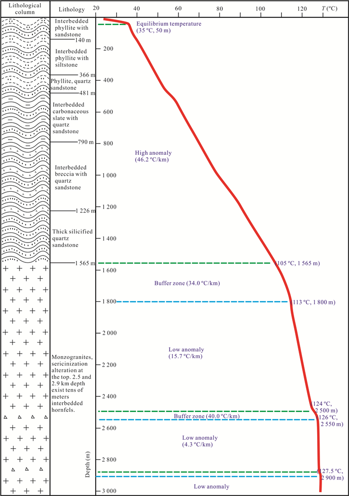
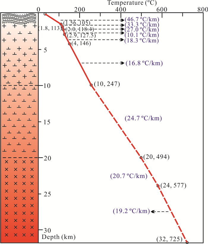
Dense distribution of granites and surrounding hot springs, the high anomalous heating rates of geothermal fluids and the high geothermal gradients in shallow crust in Southeast China are revealed by previous geothermal explorations. However, there have always been debates on the genesis of geothermal anomalies of Southeast China. It is imperative to look into the genesis mechanism of geothermal anomalies through selecting a typical geothermal field, and constructing fine crustal thermo-structure. In this study, in-depth excavation is implemented for the previous data of geophysical exploration and deep drilling exploration in the Huangshadong area. We synthetically analyze the results of radioactive heat productions (RHPs), thermophysical properties of rocks and audio-frequency magnetotellurics (AMT) sounding. This study concludes that the coefficient of radioactive heat generation (RHG) of crustal rocks and conduction heat of concealed granites is the main formation mechanism of geothermal anomalies of South China, where occurs a Great Granite Province. There is a regional indicating implication for the genesis of geothermal anomalies, taking the Huangshadong geothermal field as a typical example. It is also an important reference to guide the exploration, evaluation, development and utilization of geothermal resources in this region.
There is a tremendous amount of heat energy in the Earth interior. Volcanic eruptions, hot springs, and geothermal jets are all visible heat flow. Comparing with other clean energy sources such as solar energy, wind energy and hydro energy, geothermal energy is favored by many countries in the world due to its huge reserves, dense distribution, graded utilization and stable supply (Zhu et al., 2015). It is preliminarily estimated that geothermal reserves of the global upper crust within 10 km are about 1.3 × 1027 J (Lund et al., 2008). Assuming the global energy consumption rate is 6.5 × 10²⁰ J/year, the geothermal energy can supply the global consumption for 2.17 Ma (Hou et al., 2018; Lu, 2018). The hot dry rock energy of Chinese mainland at depths of 3–5 km is 2.5 × 1025 J, which is 2.6 × 10⁵ times of the total annual energy consumption of China (Lin et al., 2013). The utilizations of geothermal resource mainly include direct utilization and power generation (Moya et al., 2018; Zhang and Hu, 2018). High-temperature geothermal resources above 150 ℃ are mainly used for power generation (Lund and Boyd, 2015). Mid-temperature geothermal resources of 90–150 ℃ are mainly used in industry, planting, breeding, heating and refrigeration, tourism and recuperation, etc. (Wang et al., 2017). To fulfill the economic and technical feasibilities, high-temperature geothermal anomalies need to appear as shallow as possible (such as 3 km crustal depth).
Intuitionistic manifestation of geothermal anomalies is the distribution of natural hot springs or high anomalies of geothermal gradient, which is related to regional geological setting, groundwater activity, fracture and thermal conductivity of strata (Wang et al., 2016; Yuan et al., 2006). Natural hot springs are widely exposed at a connecting belt consist of Suichuan in Jiangxi to Zhanjiang in Guangdong, Hainan and Taiwan Island. The region is the most important concentrated area of hydrothermal geothermal resources in China, and there are about 500 natural hot springs above 40 ℃ in total, including 30 hot springs above 80 ℃ (Yao and Chen, 1990). Meanwhile, 315 natural hot springs are found in Guangdong Province, most of which are distributed near the large faults or at the ambient Mesozoic granite outcrops (Xiao et al., 2020; Xi et al., 2018). Logging results show high abnormal geothermal gradients of Southeast China, and it can reach 40 ℃/km in shallow groundwater (Lin et al., 2016), or even higher: the temperature gradients of Zhangzhou and Fuzhou geothermal fields are 85 and 73 ℃/km, respectively (Yuan et al., 2006). The crustal thickness of Zhangzhou is about 29 km, the depth of the Curie interface is 17–18 km, the geothermal gradient is 30–40 ℃/km, and the terrestrial heat flow is 85–113 mW/m2, which is considered to be a "cold-crust hot-mantle" type thermo-structure (Wang et al., 2015). The crustal thermo-structure of Leizhou Peninsula shows abnormally high geothermal temperatures, and the geothermal gradients of the overlying strata are above 40 ℃/km in the uplifted basement, while they are 30–37 ℃/km in the cupped basement (Chen et al., 1991). The borehole temperature of 591.5 m depth in Huangshadong geothermal field revealed by drilling ZK8 is 118.2 ℃, and the temperature gradient is as high as 76 ℃/km (Xiao et al., 2020).
On the whole, there is still a lack of systematic research on thermo-structure of the South China, and the achievement of lithospheric thermo-structure formed into previous studies needs to be consolidated and strengthened. In this study, the Huangshadong, a typical geothermal field in the Great Granite Province of South China, is selected to establish a more reasonable crustal geological structure by utilizing seismic wave velocities and geothermal drilling exploration, combining the geological inversion of AMT results of the study area. Through systematic testing and analysis, a model about rock RHP and thermal conductivity suitable for each crustal structure layer in the Huangshadong is constructed, and the crustal temperature curve is also simulated. Through precisely characterizing the crustal thermo-structure, to solve genesis mechanism of the geothermal anomalies, and effectively guide the evaluation, development and utilization of geothermal resources.
Huangshadong geothermal field is located in Hengli Town, Huicheng District, Huizhou City, Guangdong Province. Its geographical coordinate range is roughly 23°16'–23°17'N, 114°38'–114°39'E. The geological structure of Huangshadong area in the NE-SW trending Meixian-Huiyang sedimentary depression sandwiched between the NE-striking Heyuan deep fault (Tannock et al., 2020a, b) and Lianhuashan deep fault (Li J H et al., 2020), and it belongs to southern Cathaysia magma-basin ridge-continental margin tectonic belt. The tectonic sketch of Huangshadong geothermal field refers to Xiao et al. (2020). The Heyuan fault and Zijin-Boluo fault are the dominant geologic structures that control the tectonic pattern and geological evolution in this area. In the Late Huabei Period (23.5 Ma), the continental sedimentary basin was twisted by the Guangdong-Guangxi shear tectonics (Wan and Zhu, 2002). The Hengli uplift occurred large-scale thrust, and the uplifted crust has undergone weathering and denudation. Therefore, the Sinian–Carboniferous strata are mainly exposed, while there is stratigraphical break in the more recent geological time. The Jurassic–Cretaceous strata are only distributed at the edge of the uplift, and granites are exposed extensively (Fig. 1).
Field investigations show that the pre-Cretaceous strata are greatly remoulded by multi-stage tectonic movements which characterized by dense folds and faults, while the post-Cretaceous strata display relatively stable geological occurrence. Mesozoic granites are widely distributed over the Huangshadong area, such as Xiangtoushan pluton, Shirenzhang pluton, Haoyi pluton and Dadianding pluton. They mainly intruded into the pre-Cretaceous strata in Late Jurassic to Early Cretaceous (176–138 Ma) (Kuang et al., 2020; Tian et al., 2020; Xiao et al., 2020). The lithology of these Mesozoic granites consists of biotite monzogranite, a small amount of two-mica monzogranite and granodiorite. Most of the rock masses present as a batholith, stock, apophysis, or a few dyke. The latest stratum intruded by granites is the Lower Jurassic Jinji Formation, and there is a clear contact boundary.
According to the detailed investigation into geothermal geology, the Huangshadong geothermal field is located at the northeastern end of NE-striking Tonghu fault, which is the secondary fault of the Zijin-Boluo fault zone, and underground hot water is buried in the outer contact zone between Tonghu fault and concealed granite stock. Under the effect of regional tectonism, the contact zone between granitic pluton and Cambrian metamorphic sandstone, sandstone and hornstone forms fracture zone, is the main pathway for the rise of deep geothermal fluid. The NW-striking Liumingkeng fault develops in the northwest of the geothermal field extends from the Dadianding pluton to the southwest of the geothermal field and intersects with the Tonghu fault. It also belongs to the secondary fault of Zijin-Boluo fault zone, that is the main controlling-heat conducting-water structure of the geothermal field. The distribution of hot springs in Liumingkeng fault shows a beaded pattern or at the intersection of fracture zone, and most of them are exposed to low-lying lands around the granite body. Stable isotopic composition of the geothermal water is studied in this investigation, and atmospheric rainfall is the main source of geothermal hot water supply, followed by vadose zone water and surface water (in another article to be published). The groundwater recharge seeps down along faults and weathered interstices, absorbing heat during deep circulation, and rising to surface as natural hot springs or artificially exposed hot water at appropriate locations (Mao et al., 2021; Xiao et al., 2020).
Institute of Hydrogeology and Environmental Geology of the Chinese Academy of Geological Sciences (CAGS) drilled a 3-km depth scientific well of hot dry rock, "HR1", in the Huangshadong geothermal field from 2017 to 2019. The HR1 drilled into the concealed granite at 1 565 m. From shallow to deep, the lithologies of the overlying sedimentary cover are the interbedded phyllitic shale with fine sandstone, siltstone and quartz sandstone for the upper part, and interbedded carbonaceous killas with tectonic breccia and silicified quartz sandstone for the lower part. The strata show metamorphism from low grade to high grade, which indicates that thermal contact metamorphism, caused by emplacement of granitic magma, occurred in sedimentary cover. According to stratigraphic profile, Quaternary stratum is at the depth of 0–20 m, Cambrian stratum is at the depth of 20–1 109 m, Sinian stratum is at the depth of 1 109–1 565 m, and Yanshanian granites that mingled with Sinian thin layer hornstone occasionally is at the depth of 1 565–3 009 m (Fig. 2; Li T X et al., 2020).
AMT is a method to determine the resistivity of underground media by observing the plane electromagnetic wave signal caused by remote natural electromagnetism. The measurement frequency of AMT is relatively high, and the range is generally 100–104 Hz. Therefore, the resolution of shallow layer detection is relatively high. Using HR1 drilling to demarcate AMT-09 resistivity profile, it can be concluded that the Cambrian resistivities are 200–1 500 Ω·m, the Sinian resistivities are 1 500–2 100 Ω·m, and the concealed Yanshanian granite resistivities are higher than 2 100 Ω·m (Fig. 3). These resistivity isolines can be used to delineate the relief pattern of the buried depth of strata. The AMT-09 profile shows that the upper part of the left end of the blue solid line has a low resistivity characteristic, which is consistent with the weathering and loosened appearance of Triassic granite outcrop observed during field geological survey. It is speculated that the Triassic granitic pluton was broken by the intrusion of Cretaceous granite, and suffered from weathering and denuding as tectonic uplifting and compression in the later period.
Seismic reflection method is a geophysical exploration that intends to infer the properties and morphology of strata through analyzing the response of the earth to artificially induced seismic waves, which are differentiated according to the elasticity and density of underground medias. The seismic reflection profile HZ2017-01 (see appendix) shows that the sedimentary cover is characterized by obvious stratigraphic response, moderate lateral continuity of the in-phase axis, rapid change of stratigraphic dip angle, and abundant faults and folds. HR1 drilled into granitic pluton at 1 565 m, and the seismic facies of upper and lower strata at the interface are significantly different. The top surface of the concealed granite is mainly located at the depth of 1.4–2.2 km, and the bottom surface is at 3.6–4.8 km. Therefore, the average thickness of granitic pluton is about 2.4 km. Meanwhile, the U-Pb crystallization ages of Id-30 sample collected from the Liumingkeng pluton and Id-33 sample collected from the drilling ZK8 are 253 and 143 Ma, respectively (Xiao et al., 2020). Combined with the AMT-09 resistivity profile, the HZ2017-01 seismic phase, the geothermal drilling HR1 and geothermal geology, it is shown that a large area of Cretaceous concealed granite is distributed under the Triassic granite outcropping.
Seismic wave velocity detection reveals that the Moho depth of the Lianxian-Conghua-Huizhou-Gangkou profile is about 33–30 km (Deng et al., 2011; Xiong et al., 2009), and the wave velocity profile passes through the Huangshadong area from northwest to southeast. According to the P-wave velocity characteristics in Huangshadong area (Fig. 4a) and geothermal exploration, the crustal geological model of Huangshadong geothermal field (Fig. 4b) is established: the depth of the upper crust is 0–10 km, the wave velocity is 5.4–6.2 km/s, with the average velocity of 6.0 km/s. Among them, 0–1.1 km depth is Cambrian stratum; 1.1–1.6 km is Sinian stratum; 1.6–4 km depth is composed of granite and diorite; and 4–10 km depth is composed of granodiorite. The P-wave velocity of the middle crust is stable at 6.2 km/s and the corresponding depth is 10–20 km. It is composed of diorite rocks. The wave velocity of the lower crust is 6.2–6.8 km/s, the average velocity is 6.7 km/s, the corresponding depth is 20–32 km, and the average composition is equivalent to gabbro. The Moho interface is buried at a depth of 32 km, and the lithospheric mantle velocity below the Moho surface changed to 8.0 km/s (Xiong et al., 2009; He et al., 2008).
A reasonable thermo-structure is the key to accurately analyze the genetic mechanism of geothermal anomaly, and the anatomy of deep thermo-structure benefits from the comprehensive reflections of geothermal drilling, geophysical exploration, geothermal geology, petrogeochemistry and thermophysical properties. Analyzing the data sets of terrestrial heat flow, crustal thickness and vertical distribution of heat producing elements shows that there is no strictly linear relationship between the RHG and heat flux in a certain depth of strata. Even within a single geological unit, heat producing elements are spatially significantly heterogeneous. For a given crustal thickness, based on the calculation of terrestrial heat flow and crustal heat generation, the Moho temperature difference can be up to 300 ℃ (Xiong et al., 2009; He et al., 2008). In the relatively stable continental crust, the temperature of concealed pluton has cooled at thermal equilibrium state, and the radioactive heat generated by crustal rocks with great difference occupies a major part in the terrestrial heat flow. Therefore, a crustal thermo-structure must to be established through measuring heat flow and RHG, and the relationship between seismic wave velocity, crustal thickness, stratigraphy and heat flux, as well as the temperature distribution in the crust, need to be studied (Mareschal and Jaupart, 2013).
Terrestrial heat flow is usually used to measure the transfer of heat energy from Earth's interior to the surface, and the value is calculated by the following formula.
Q_{0} = λ·ΔT | (1) |
where Q0 is the terrestrial heat flow in mW/m2; λ is the thermal conductivity of rocks in W/(m·℃); ΔT is the geothermal gradient in ℃/km. In the measurement of terrestrial heat flow, the thermal conductivity of rocks was measured by selecting the representative rock samples in the region and using thermal conductivity instrument in the laboratory; and the geothermal gradient was obtained from drilling temperatures. The rocks of different strata or lithologies in Huangshadong area were systematically sampled, and the petrochemistry and thermophysical properties were tested. Detailed results were shown in appendix. Referring to the test results, the thermal conductivities of Cambrian and Sinian rocks are relatively uniform, approaching to 2.5 W/(m·℃). Therefore, it was selected as the average thermal conductivity value of the overlying strata.
For heat flow correction, three times of temperature logging were performed on HR1 at 24, 48, and 72 h after well completion, respectively. In the last temperature measurement, the equilibrium temperature of HR1 was stable at 118.4 ℃ at 2 000 m depth, and its average geothermal gradient was 42.8 ℃/km. When drilling into the granitic pluton, the geothermal gradient decreased. The geothermal gradient of 1 565–2 000 m depth was calculated separately, which was about 30.8 ℃/km. The temperature of the later deepened drilling was stable at 127.5 ℃ at 2 900 m depth, so the geothermal gradient in the range of 2 000–2 900 m was 10.1 ℃/km. There were two temperature abrupt transitions in the well sections of 2 400–2 500 m and 2 750–2 800 m, indicating the rapid convection of hot water in the aquifer.
Through in-depth study of temperature measurement of HR1 (Fig. 2), it displays that the whole-well geothermal gradient, which is characterized by nonlinear segmentation, generally decreases from top to bottom. Between two relatively stable geothermal gradients (linear) on the temperature measurement curve, there is a curve segment of unstable temperature gradient, which is called "geothermal gradient buffer" in the Fig. 2, and it tends to have a higher average geothermal gradient. For example, the average geothermal gradient in the sericitization monzogranite of 1 565–1 800 m depth was 34 ℃/km, and the Sinian hornfels of 2 500–2 550 m depth was 40 ℃/km. They are characterized by non-dense structure, fracture zone and weathered zone, and the corresponding rocks have high porosity, high moisture, and low thermal conductivity. The obvious difference is that the gradient values of the stable intervals of geothermal gradient were not uniform with depth. For instance, the stable geothermal gradient was 46.7 ℃/km in the Cambrian metasedimentary at a depth of 50–1 565 m, showing high anomaly. It was 15.7 ℃/km in the granitic pluton at 1 800–2 500 m, showing low anomaly. Moreover, an extremely low geothermal gradient, 4.3 ℃/km, for the granitic pluton at 2 550–2 900 m. It is mainly determined by the petrophysical properties of stratum rocks. The granitic pluton is often dense and massive, with significantly lower porosity, fissure degree and moisture than the sedimentary rocks and the metasedimentary rocks, which results in a lower geothermal gradient for the concealed granites.
Therefore, the stable geothermal gradient on the upper HR1 temperature curve (50–1 565 m), 46.7 ℃/km, was selected as the terrestrial heat flow calculation. The terrestrial heat flow of Huangshadong geothermal field was 115.5 mW/m2, which is higher than the average value of Huangshadong area obtained from previous studies, 73 mW/m2 (Lin et al., 2016). It is also significantly higher than the latest average heat flow of the continental China, 61.4 mW/m2 (Jiang et al., 2019). Deep drilling was carried out in Shiba Basin, 30 km to the north of Huangshadong area, and the drilling temperature measurement shows that the geothermal gradient was significantly lower than that in Huangshadong area (running project). According to Hu et al. (2001), "the heat flow measured in the geothermal anomaly area belongings to category D", the measured value of terrestrial heat flow in Huangshadong geothermal field in this paper is category D. Through the analysis of the formation mechanism of geothermal anomaly in the following sections, we will elaborate the formation of locally high geothermal anomaly.
The Meso-Cenozoic sedimentary layers in the Huangshadong geothermal field are too thin to consider its contribution of radiogenic heat, and the most superficial layers of the crust, which forms the shallow sedimentary cover of the geothermal field, are mainly Cambrian and Sinian metamorphic siltstone, slate, hornfels, phyllite, interbedded siliceous and schist. The RHPs were calculated by means of lithologic classification, and the corresponding results were shown in Table 1. According to the HR1 and geophysical exploration, 1.6 km is taken as average thickness of the sedimentary cover, that is, the buried depth of granitic pluton. The sedimentary cover is approximately composed of Cambrian and Sinian strata, which account for 11/16 and 5/16 of the total thickness, respectively. The RHP of Cambrian stratum is 2.43 μW/m3 in this study, the RHP of Sinian stratum employs Zhao et al. (1995) results, 2.13 μW/m3. It is calculated that average RHP of the sedimentary cover is 2.34 μW/m3, and the RHG contributes 3.7 mW/m2 to terrestrial heat flow (Fig. 5). Geophysical exploration shows that there is a concealed granitic pluton with an average thickness of 2.4 km below the sedimentary cover. Combined with regional geology, the depth range is set to consist of 80% Early Cretaceous granite and 20% diorite. The RHP of Early Cretaceous granite is 6.01 μW/m3, and the diorite is 1.89 μW/m3. Therefore, the average RHP of the concealed granite is 5.19 μW/m3, and its RHG contributes 12.5 mW/m2 to terrestrial heat flow (Fig. 5). The upper crust below the concealed granite is composed of granodiorite rocks (4–10 km), and the average RHP value of the granodiorite is 2.59 μW/m3. This layer contributes 15.5 mW/m2 to terrestrial heat flow. The above three layers constitute the upper crustal RHG structure of the Huangshadong geothermal field, and the RHG supplies a total of 31.7 mW/m2 heat flux (Fig. 5).
Lithology | ρ (g/cm3) |
λ (W/(m·ºC)) |
K (wt.%) |
Th (ppm) |
U (ppm) |
A (μW/m3) |
Zhao et al. (1995) | Rybach (1988) | Hasterok et al. (2018) |
Granite (T) | 2.57 | 2.4 | 3.44 | 11.90 | 12.61 | 4.18 | 4.2 |
2.5 |
2.7 |
Granite (J) | 2.59 | 2.0 | 4.01 | 36.86 | 13.13 | 6.05 | |||
Granite (K) | 2.59 | 2.1 | 4.25 | 42.11 | 11.50 | 6.01 | |||
Granodiorite | 2.57 | 2.2 | 2.27 | 19.23 | 4.58 | 2.59 | 3.5 | 1.50 | 1.5 |
Dacite | 2.62 | -- | 4.04 | 26.10 | 2.89 | 2.84 | 2.7 | 1.50 | 1.2 |
Diorite | 2.72 | 2.2 | 2.25 | 13.10 | 2.97 | 1.89 | 2.0 | 1.08 | 0.93 |
Tuff | 2.55 | 2.4 | 2.84 | 17.14 | 3.43 | 2.20 | 2.7 | -- | -- |
Quartz vein | 2.63 | 2.5 | 0.57 | 2.75 | 0.53 | 0.37 | -- | -- | -- |
Basalt | 2.68 | -- | 0.36 | 2.01 | 0.14 | 0.21 | 0.73 | 0.31 | 0.54 |
Dolerite | 2.76 | 2.5 | 2.41 | 7.54 | 1.44 | 1.14 | 0.71 | -- | 0.9 |
Quartz sandstone | 2.64 | 2.5 | 2.17 | 13.37 | 1.66 | 1.52 | 2.1 | 0.58 | -- |
Carbon mudstone | 2.75 | 2.5 | 3.30 | 16.43 | 3.54 | 2.40 | 2.0 | 1.80 | 1.7 |
Marble | 2.69 | 2.6 | 0.56 | 2.50 | 1.54 | 0.62 | 0.51 | -- | -- |
Limestone | 2.68 | -- | 0.00 | 0.07 | 0.34 | 0.09 | 0.59 | 0.62 | 0.56 |
Apogrite | 2.73 | 2.5 | 1.87 | 16.04 | 2.81 | 2.03 | 1.8 | 0.99 | 1.7 |
At present, geothermal drilling is not able to explore the middle-lower crust at a depth of 10 km, and the lithology of these layers is inferred based on existing regional geological achievement. Studies of the 5 km scientific deep drilling of the "Chinese Continental Scientific Drilling" (CCSD) in Donghai, Jiangsu, located in the Sulu ultrahigh-pressure metamorphic belt is an important reference for this study (Deng et al., 2011; He et al., 2009, 2006; Wu et al., 2005). According to the broad consensus of geology and geochemistry, the middle crust is mainly composed of intermediate diorite rocks, while the lower crust is composed of basic gabbro rocks. Referring to the deep magmatic activity products such as diorite and diabase, the average RHP of middle crust is selected from the diorite RHP in this study, 1.89 μW/m3, which supplies 18.9 mW/m2 heat flux. The average RHP of lower crust is 1.14 μW/m3, which contributes 13.7 mW/m2 heat flux (Fig. 5).
Crustal RHP structure and heat flux model of the Huangshadong geothermal field are established based on the above RHP parameters from shallow to deep layer by assigning values one by one, as shown in Fig. 5. It displays that heat flux derived from the RHG of crustal rocks is 64.3 mW/m2, while that derived from mantle is 51.2 mW/m2. The crust-derived heat flux accounts for 56% of terrestrial heat flow, which is called "hot crust and cold mantle" type thermo-structure. This is a unique crustal thermo-structure of the Great Granite Province of South China. Compared with the previous research on lithospheric thermo-structure of the coastal areas of Fujian and Guangdong, the higher contribution to crustal heat flow is attributed to the various types of crustal rocks with high RHP, which were successively migrated and enriched into the middle-upper crust through multi-period granitic magmatic activities in Mesozoic. The multi-period granitic magmatism continuously adjusts the lithospheric thermo-structure in the Great Granite Province, which is extremely conducive to the formation of "hot crust and cold mantle" type high heat flow region.
The temperature measurement of HR1 showed that the equilibrium temperature is about 35 ℃ at a depth of 50 m, the average geothermal gradient inside Cambrian stratum is 46.7 ℃/km. The temperature at a depth of 2.0 km is 118.4 ℃, and the 2.9 km depth is 127.5 ℃, and the 3.0 km depth is 127.7 ℃ (Li T X et al., 2020). The temperature gradients decrease after drilling into concealed granite. As can be seen from Fig. 5a, the average RHP of crustal rocks also presents a segmented decreasing trend. It is known that the Moho depth of the Huangshadong area is 32 km (Xiong et al., 2009), and the Moho temperature is about 700 ℃ (Jaupart et al., 2016). The Curie interface depth is 24 km, and the temperature Curie interface is about 585 ℃ (Xiong et al., 2016). Taking the above restrictive conditions and the crustal geological model of Huangshadong geothermal field as references, an empirical formula for one-dimensional steady-state model is used to estimate the crustal temperature (Lin et al., 2013; He et al., 2009).
T=T_0+Q_0 \cdot X / \lambda-A \cdot X^2 / 2 \lambda | (2) |
Where X is the calculating depth, T is the temperature at depth X, T0 is the shallow stable temperature, Q0 denotes the terrestrial heat flow, 115.5 mW/m2, λ represents the thermal conductivity, and A is the RHP. Since the thermophysical parameters of each layer of the crust do not change strictly regularly, it is necessary to calculate crustal temperatures one layer by one layer. In order to scientifically predict the crustal temperature structure, the stratification calculation was carried out according to the HR1 temperature curve. Therefore, Formula 2 is adjusted as follows.
T = T_{x} + Q_{x}·(X - x)/λ_{x} - A_{x}·(X - x)^{2}/2λ_{x} | (3) |
Where x denotes the top-surface depth of the corresponding layer, Tx is the top-surface temperature of the corresponding layer, Qx is the top-surface heat flux of the corresponding layer, λx is the mean thermal conductivity of the corresponding layer, and Ax is the mean RHP of the corresponding layer. All parameter values are shown in Fig. 5, and the layered calculation results are shown in Fig. 6.
When depth X = 1.56 km, the crustal temperature T1.56 = 35 + 115.5 × (1.56 - 0.5)/λ1.56 - 2.34 × (1.56 - 0.5)2/2λ1.56 = 35 +171.7/λ1.56 = 105 ℃. Therefore, the shallow crustal average thermal conductivity λ1.56 is 2.45 W/(m·℃) by calculation. This value is close to the 2.5 W/(m·℃) of the rock samples collected in the Huangshadong area measured at room temperature, which reflects the favourable applicability of the one-dimensional steady-state model in the Huangshadong geothermal field.
Similarly, when depth X = 1.8 km, T1.8 = 105 + (115.5 - 3.7) × (1.8 - 1.56)/λ1.8 - 5.19 × (1.8 - 1.56)2/2λ1.8 = 105 + 26.7/λ1.8 = 113 ℃. Therefore, the λ1.8 is 3.33 W/(m·℃) at 1.56–1.8 km depth, and the geothermal gradient is 33.3 ℃/km.
When depth X = 2.0 km, T2.0 = 113 + (111.8 - 5.19 × (1.8 - 1.56)) × (2.0 - 1.8)/λ2.0 - 5.19 × (2.0 - 1.8)2/2λ2.0 = 113 + 76.1/λ2.0= 118.4 ℃. The λ2.0 is 4.08 W/(m·℃) at 1.8–2.0 km depth, and the geothermal gradient is 27.0 ℃/km.
When depth X = 2.9 km, T2.9 = 118.4 + (111.8 - 5.19 × (2.0 - 1.56)) × (2.9 - 2.0)/λ2.9 - 5.19 × (2.9 - 2.0)2/2λ2.9 = 118.4 + 42.2/λ2.9 = 127.5 ℃. The λ2.9 is 10.6 W/(m·℃) at 2.0–2.9 km depth, and the geothermal gradient is 10.1 ℃/km.
The above calculation results display that the thermal conductivities of the 3 km depth crust have increasing trend as a whole. Combined with the HR1 lithology logging, the thermal conductivity of block-shaped concealed granite is obviously higher than that of the broken water-bearing loose-shaped rocks. All these characteristics reflect that within the depth range, the rock structure including density and moisture restrict the thermal conductivity.
Referring to crustal RHP model of the Huangshadong geothermal field and the thermal conductivity of stable geothermal gradient in the 1.56–2.9 km depth, 16.8 ℃/km is selected as the mean geothermal gradient of 2.9–10 km stratum. It can be inferred that when depth X = 4.0 km, T4.0 = 127.5 + 16.8 × (4.0 - 2.9) = 146 ℃; When depth X = 10 km, T10 = 146 + 16.8 × (10 - 4)= 247 ℃.
When depth X = 4.0 km, T4.0 = 127.5 + (111.8 - 5.19 × (2.9 - 1.56)) × (4 - 2.9)/λ4.0 - 5.19 × (4 - 2.9)2/2λ4.0 = 127.5 + 112.2/λ4.0 = 146 ℃. The λ4.0 is 6.1 W/(m·℃) at 2.9–4.0 km depth.
When depth X = 10 km, T10 = 146 + (111.8 - 5.19 × (4 - 1.56)) × (10 - 4)/λ2.9 - 2.59 × (10 - 4)2/2λ10 = 146 + 548.2/λ10 = 247 ℃. The λ10 is 5.4 W/(m·℃) at 4.0–10 km depth.
Thermophysical properties tested for high-temperature rocks have proven that the thermal conductivity of different lithologies decreases with increasing temperature, and the difference of thermal conductivity decreases accordingly, and tends to a stable value after sufficiently high temperature (Jaupart et al., 2016). Using the boundary condition of Curie interface temperature at 24 km depth in the Huangshadong area, 580 ℃, and the mean thermal conductivity of middle-lower crust is selected to be 3 W/(m·℃).
When depth X = 20 km, T20 = 247 + 83.6 × (20 - 10)/3 - 1.89 × (20 - 10)2/6 = 494 ℃. The geothermal gradient is 24.7 ℃/km at 10–20 km depth.
When depth X = 24 km, T24 = 494 + 64.7 × (24 - 20)/3 - 1.14 × (24 - 20)2/6 = 577 ℃. The geothermal gradient is 20.7 ℃/km at 20–24 km depth.
When depth X = 32 km, T32 = 494 + 64.7 × (32 - 20)/3 - 1.14 × (32 - 20)2/6 = 725 ℃. The geothermal gradient is 19.2 ℃/km at 20–32 km depth.
Crustal temperature structure of the Huangshadong geothermal field simulated by the one-dimensional steady-state model modified by drilling and geophysical explorations is shown in Fig. 6. It displays that the geothermal gradient has a tendency to decrease with increasing depth on the whole, and it is restricted the mean thermal conductivity, the RHP and the heat flux of strata. In the shallow upper crust (above 1.56 km depth), due to the high moisture, porosity and fracture degree of stratum rock, and the mean thermal conductivity is relatively small. It is easy to infer that the geothermal gradient within this depth range will be significantly high according to the calculation formula of heat flow. However, the concealed granite pluton within 1.56–4 km depth shows a dense block structure, extremely low moisture, high density, and low porosity and fracture degree. As a result, the rock thermal conductivity is extremely high, making the geothermal gradient inside the pluton (16.8 ℃/km) much smaller than that of the upper water-bearing strata (46.7 ℃/km). In 10–32 km depth range of the middle-lower crust, the geothermal gradient decreases slowly, 24.7→20.7→19.2 ℃/km, and the geothermal gradient is mainly related to heat flux of the corresponding layer.
It is well known that there are three main modes of thermal transmission: heat conduction, heat convection and heat radiation. The massive heat energy stored in the Earth continuously dissipates into atmosphere through these modes. In the stable continental lithosphere, heat conduction between stratum rocks is the most important mode of thermal transmission. There are different viewpoints for the genesis of geothermal anomalies in the geothermal fields of South China, due to utilize different geothermal exploration means and methods. One standpoint holds that large-scale modern volcanic activities took place in the Southeast China, local high-conductivity and low-resistance layers exist in the deep crust, and molten magma chamber provide higher heat to the upper crust through upwelling mantle channels (Wu et al., 2019, 2018). Another view deems that granites in South China have a high RHP, and the densely distributed granites provide sufficient heat energy for shallow crust, resulting in geothermal anomalies (Tannock et al., 2019). In addition, some experts believe that there may be concealed Cenozoic acidic pluton in the upper crust and residual heat from magma crystallization (Lin et al., 2016). The geothermal genesis complex of active strike-slip faults, heat release of upwelling mantle and RHG effect is also under discussion (Morgan, 1984). In this study, the genetic mechanism of geothermal anomalies in the Great Granite Province of South China is discussed based on the contribution to crustal rock RHG and the heat conduction effect of concealed granitic pluton.
The heat released by radioactive decay of the elements U, Th and K in rocks is an important heat source in the Earth, and granitoids hold the highest RHP, which has attracted much attention. In the region with stable thermal state, terrestrial heat flow is composed of crust-derived heat flow (Qc) and Mohosurface heat flow (or mantle-derived heat flow, Qm) (Morgan, 1984). The Qm variation is small in crustal stable area, and the magnitude of terrestrial heat flow directly reflects the Qc. Studying on the Qc of crustal basements (2.7–0.4 Ga) shows that high heat flow is not specific to a particular geological period. In the case of obvious difference in crustal thickness (32–43 km), the terrestrial heat flow varies in the range of 44–92 mW/m2. Here, Qm varies in a limited range from 15 to 18 mW/m2, while Qc varies in a wide range from 29 to 77 mW/m2 (Jaupart et al., 2016; Mareschal and Jaupart, 2013).
The mean RHPs of Mesozoic granites of different geological periods in Huangshadong area (Table 1) show that the mean RHP of Indosinian (253 Ma) granites is 4.18 μW/m3, that of Early Yanshanian granites (175–155 Ma) is 6.05 μW/m3, and that of Late Yanshanian granites (140 Ma) is 6.01 μW/m3. Among them, the most large-scale granitic intrusion occurred at 158 Ma in the South China, and the granites hold extremely high RHPs, up to 9 μW/m3 (Zhou et al., 2020, 2016). It is speculated that multi-period granitic magmatism in the South China continuously promotes promoted the enrichment of RHG elements in granites. In addition, the larger the granitic magma scale is, the longer the cooling crystallization time is, the more favorable for the high-intensitive crystal fractionation to form high RHP granites.
According to this test and the results of Zhao et al. (1995) for the RHPs of various lithology in the Southeast China, the crust-derived rocks of Southeast China show significantly higher RHPs compared with the global mean values (Table 1). We hold the opinion that frequent tectono-magmatic activities promoted granitic pluton to outcrop the surface, underwent long-term weathering and denudation, and became an important material source for sedimentation, leading to significantly high RHPs of stratum rocks. At the same time, intense crust-mantle differentiation resulted in abnormally low RHP of Huangshadong basalts.
The RHPs of each layer in Huangshadong were estimated by the crustal geological model (Fig. 5), showing that the heat flow derived from crustal RHG is 64.3 mW/m2, which accounts for 56% of the terrestrial heat flow. The heat flow generated by the upper crust rocks (above 10 km depth) contributes up to 31.7 mW/m2, which accounts for 49% of the crust-derived heat flow. In contrast, the crust thickness of Zhangzhou geothermal field is 29 km, the buried depth of Curie interface is 17–18 km, and the terrestrial heat flow is 90–115 mW/m2. The intrusive period of Zhangzhou granites is relatively single, and the granites have a mean RHP of 3.7 μW/m3. The heat flows derived from crust and mantle are 37–45 mW/m2, 45–75 mW/m2, respectively (Wang et al., 2015). Therefore, mantle-derived heat flow is the most important contributor in the Zhangzhou terrestrial heat flow. There are obvious differences in the Huangshadong geothermal field, and the multi-period granitic magmatism plays a more critical role in the adjustment of crustal thermo-structure. The latest researches also show that the distribution of hot springs in the South China continent is closely related to the size of the granite intrusive bodies with high RHP, and there is no modern magma chamber containing huge residual heat in the middle-upper crust (Zhou et al., 2020). Therefore, we deem that multi-period acidic magmatic activities promoted the concentration of RHG elements in the middle-upper crust of the Great Granite Province of South China, and the RHGs of crustal rocks contribute more than mantle-derived heat flux, which is an important heat source condition for the formation of typical geothermal fields and a key genetic mechanism for the geothermal anomalies.
Combined with the AMT-09 resistivity profile, HR1 temperature curve and crustal temperature structure, a geothermal model of 5.0 km depth shallow crust in the Huangshadong geothermal field is established in Fig. 7. The isotherm distribution is simulated, reflecting that the concealed Yanshanian granite has excellent thermal conductivity as a block-shaped hot dry rock system, longitudinally attracting heat from deep crust rapidly, resulting in high temperatures and geothermal gradient anomalies in the upper strata (Mao et al., 2018), as shown in Fig. 6, the isotherms are densely distributed in a certain depth range above the concealed granite. Differently, the geothermal gradients in the concealed granite is lower, which is reflected by the wider isotherm spacing than the upper strata.
From the horizontal comparison, the concealed granite conducts more heat energy than the surrounding rocks due to its significantly high thermal conductivity, and the temperatures of concealed granites at a certain depth are higher, which also leads to the high geothermal gradient anomalies above the concealed granites. The abnormally high heat energy generated in the above geological processes can be absorbed by fault zone water, pore water and fissure water, thus forming shallow geothermal displays, such as underground hot water and hot springs. Due to different fault depths and mixing ratios of leaching water, the geothermal well investigations of the Huangshadong area show that the underground hot water temperatures at a certain depth are inconsonant.
(1) Terrestrial heat flow of the Huangshadong geothermal field is 115.5 mW/m2, and the crustal RHG contributes 64.3 mW/m2 heat flow, accounting for 56% of the terrestrial heat flow. It is a "hot crust and cold mantle" type thermo-structure.
(2) Under the joint control of the mean thermal conductivity, RHP, and the heat flux at a certain depth, the geothermal gradient of Huangshadong tends to decrease as the depth increases in the same stratum. In the shallow upper crust, due to the high moisture, porosity and fracture degree of stratum rock, the mean thermal conductivity is relatively small, and the corresponding geothermal gradient is significantly high. However, the concealed granite pluton has extremely low moisture, high density, and low porosity and fracture degree, the rock thermal conductivity is significantly high, and the geothermal gradient inside the pluton much smaller than that of the upper water-bearing strata.
(3) Taking Huangshadong geothermal field as a typical area, the geothermal anomaly mechanism of the Great Granite Province of South China is restricted by the double aspects of the crustal rocks with highly abnormal RHP and the concealed granites with abnormally high thermal conductivity. The multi-period granitic magmatism promotes the upward migration and enrichment of RHG elements, adjusts the thermal structure, and brings the high RHP crustal rocks into being. In addition, the high temperatures and geothermal gradient anomalies occur in the upper strata due to the high thermal conductivity of the concealed granites.
ACKNOWLEDGMENTS: This study was financially supported by the China Geological Survey (No. 1212011220014). Thanks go to Xiaoxiong Chen from Jianghan Branch, SINOPEC Petroleum Engineering Geophysics Co. LTD and Haonan Gan from Institute of Hydrogeology and Environmental Geology, Chinese Academy of Geological Sciences for providing supporting materials for this study. We would like to thank the anonymous reviewers for their constructive comments and suggestions which greatly improved the manuscript. The final publication is available at Springer via https://doi.org/10.1007/s12583-021-1486-z.Chen, M. X., Xia, S. G., Yang, S. Z., 1991. Local Geothermal Anomalies and Their Formation Mechanisms on Leizhou Peninsula, South China. Chinese Journal of Geology, 26(4): 369–383 (in Chinese with English Abstract) |
Deng, Y. F., Li, S. L., Fan, W. M., et al., 2011. Crustal Structure beneath South China Revealed by Deep Seismic Soundings and Its Dynamics Implications. Chinese Journal of Geophysics, 54(10): 2560–2574 (in Chinese with English Abstract) doi: 10.3969/j.issn.0001-5733.2011.10.013 |
Hasterok, D., Gard, M., Webb, J., 2018. On the Radiogenic Heat Production of Metamorphic, Igneous, and Sedimentary Rocks. Geoscience Frontiers, 9(6): 1777–1794. https://doi.org/10.1016/j.gsf.2017.10.012 |
He, L. J., Hu, S. B., Huang, S. P., et al., 2008. Heat Flow Study at the Chinese Continental Scientific Drilling Site: Borehole Temperature, Thermal Conductivity, and Radiogenic Heat Production. Journal of Geophysical Research, 113(B2): B02404. https://doi.org/10.1029/2007jb004958 |
He, L. J., Hu, S. B., Yang, W. C., et al., 2006. Heating Generation Model for the Continental Crust Based on the Main Hole of the Chinese Continental Scientific Drilling Project. Acta Petrologica Sinica, 22(11): 2808–2814 (in Chinese with English Abstract) |
He, L. J., Hu, S. B., Yang, W. C., et al., 2009. Radiogenic Heat Production in the Lithosphere of Sulu Ultrahigh-Pressure Metamorphic Belt. Earth and Planetary Science Letters, 277(3/4): 525–538. https://doi.org/10.1016/j.epsl.2008.11.022 |
Hou, J. C., Cao, M. C., Liu, P. K., 2018. Development and Utilization of Geothermal Energy in China: Current Practices and Future Strategies. Renewable Energy, 125: 401–412. https://doi.org/10.1016/j.renene.2018.02.115 |
Hu, S. B., He, L. J., Wang, J. Y., 2001. Compilation of Heat Flow Data in the China Continental Area (3rd Edition). Chinese Journal of Geophysics, 44(5): 611–626 (in Chinese with English Abstract) doi: 10.3321/j.issn:0001-5733.2001.05.005 |
Jaupart, C., Mareschal, J. C., Iarotsky, L., 2016. Radiogenic Heat Production in the Continental Crust. Lithos, 262: 398–427. https://doi.org/10.1016/j.lithos.2016.07.017 |
Jiang, G. Z., Hu, S. B., Shi, Y. Z., et al., 2019. Terrestrial Heat Flow of Continental China: Updated Dataset and Tectonic Implications. Tectonophysics, 753: 36–48. https://doi.org/10.1016/j.tecto.2019.01.006 |
Kuang, J., Qi, S. H., Wang, S., et al., 2020. Granite Intrusion in Huizhou, Guangdong Province and Its Geothermal Implications. Earth Science, 45(4): 1466–1480 (in Chinese with English Abstract) |
Li, J. H., Cawood, P. A., Ratschbacher, L., et al., 2020. Building Southeast China in the Late Mesozoic: Insights from Alternating Episodes of Shortening and Extension along the Lianhuashan Fault Zone. Earth-Science Reviews, 201: 103056. https://doi.org/10.1016/j.earscirev.2019.103056 |
Li, T. X., Lin, W. J., Gan, H. N., et al., 2020. Research on the Genetic Model and Exploration Progress of Hot Dry Rock Resources on the Southeast Coast of China. Journal of Geomechanics, 26(2): 187–200 (in Chinese with English Abstract) |
Lin, W. J., Gan, H. N., Wang, G. L., et al., 2016. Occurrence Prospect of HDR and Target Site Selection Study in Southeastern Coast of China. Acta Geologica Sinica, 90(8): 2043–2058 (in Chinese with English Abstract) doi: 10.3969/j.issn.0001-5717.2016.08.031 |
Lin, W. J., Liu, Z. M., Wang, W. L., et al., 2013. The Assessment of Geothermal Resources Potential of China. Geology in China, 40(1): 312–321 (in Chinese with English Abstract). doi: 10.3969/j.issn.1000-3657.2013.01.021 |
Lu, S. M., 2018. A Global Review of Enhanced Geothermal System (EGS). Renewable and Sustainable Energy Reviews, 81: 2902–2921. https://doi.org/10.1016/j.rser.2017.06.097 |
Lund, J. W., Bjelm, L., Bloomquist, G., et al., 2008. Characteristics, Development and Utilization of Geothermal Resources―A Nordic Perspective. Episodes, 31(1): 140–147. https://doi.org/10.18814/epiiugs/2008/v31i1/019 |
Lund, J. W., Boyd, T. L., 2015. Direct Utilization of Geothermal Energy 2015 Worldwide Review. In Proceedings of World Geothermal Congress 2015, Melbourne, Australia |
Mao, X. M., Zhu, D. B., Ndikubwimana, I., et al., 2021. The Mechanism of High-Salinity Thermal Groundwater in Xinzhou Geothermal Field, South China: Insight from Water Chemistry and Stable Isotopes. Journal of Hydrology, 593: 125889. https://doi.org/10.1016/j.jhydrol.2020.125889 |
Mao, X. P., Wang, X. W., Li, K. W., et al., 2018. Sources of Heat and Control Factors in Geothermal Field. Earth Science, 43(11): 4256–4266 (in Chinese with English Abstract) |
Mareschal, J. C., Jaupart, C., 2013. Radiogenic Heat Production, Thermal Regime and Evolution of Continental Crust. Tectonophysics, 609: 524–534. https://doi.org/10.1016/j.tecto.2012.12.001 |
Morgan, P., 1984. The Thermal Structure and Thermal Evolution of the Continental Lithosphere. Physics and Chemistry of the Earth, 15: 107–193. https://doi.org/10.1016/0079-1946(84)90006-5 |
Moya, D., Aldás, C., Kaparaju, P., 2018. Geothermal Energy: Power Plant Technology and Direct Heat Applications. Renewable and Sustainable Energy Reviews, 94: 889–901. https://doi.org/10.1016/j.rser.2018.06.047 |
Rybach, L., 1988. Determination of Heat Production Rate. In: Haenel, R., Rybach, L., Stegena, L., eds., Handbook of Terrestrial Heat Flow Density. Kluwer Academic Publishers, Holland. 125–142 |
Tannock, L., Herwegh, M., Berger, A., et al., 2020a. The Effects of a Tectonic Stress Regime Change on Crustal-Scale Fluid Flow at the Heyuan Geothermal Fault System, South China. Tectonophysics, 781: 228399. https://doi.org/10.1016/j.tecto.2020.228399 |
Tannock, L., Herwegh, M., Berger, A., et al., 2020b. Microstructural Analyses of a Giant Quartz Reef in South China Reveal Episodic Brittle-Ductile Fluid Transfer. Journal of Structural Geology, 130: 103911. https://doi.org/10.1016/j.jsg.2019.103911 |
Tannock, L., Wang, Y., Li, J. F., et al., 2019. A Preliminary Study on the Mechanics and Tectonic Relationship to the Geothermal Field of the Heyuan Fault Zone in Guangdong Province. Journal of Geomechanics, 25(3): 400–411 (in Chinese with English Abstract) |
Tian, F., Qi, S. H., Wang, S., et al., 2020. Characteristics of Radioactive Heat Production Rate of Rocks in Shiba-Huangshadong Area, Huizhou, Guangdong Province. Chinese Journal of Geology (Scientia Geologica Sinica), 55(4): 1277–1289 (in Chinese with English Abstract) |
Wan, T. F., Zhu, H., 2002. Tectonics and Environment Change of Meso-Cenozoic China Continent and Its Adjacent Areas. Geoscience, 16(2): 107–120 (in Chinese with English Abstract) |
Wang, A. D., Sun, Z. X., Liu, J. H., et al., 2015. Radiogenic Heat Production of Rocks from Zhangzhou, Southeast China and Its Implications for Thermal Regime of Lithosphere. Science & Technology Review, 33(24): 41–45 (in Chinese with English Abstract) |
Wang, A. D., Sun, Z. X., Liu, J. H., et al., 2016. Thermal Conductivity and Radioactive Heat-Producing Element Content Determinations for Rocks from Zhangzhou Region, SE China, and Their Constraints on Lithospheric Thermal Regime. Environmental Earth Sciences, 75(17): 1213. https://doi.org/10.1007/s12665-016-6020-8 |
Wang, G. L., Zhang, W., Liang, J. Y., et al., 2017. Evaluation of Geothermal Resources Potential in China. Acta Geoscientica Sinica, 38(4): 448–459 (in Chinese with English Abstract) |
Wu, C. F., Hu, X. Y., Wang, G. L., et al., 2018. Magnetotelluric Imaging of the Zhangzhou Basin Geothermal Zone, Southeastern China. Energies, 11(8): 1–15. https://doi.org/10.3390/en11082170 |
Wu, C. F., Hu, X. Y., Wang, G. L., 2019. Magnetotelluric Studies in the Zhangzhou Basin Geothermal Zone, Southeastern China. Acta Geologica Sinica, 93: 277–277 (in Chinese with English Abstract) doi: 10.1111/1755-6724.14088 |
Wu, Y., Jin, Z. M., Ou, X. G., et al., 2005. Lithospheric Thermal Structure Beneath of the Area of the Chinese Continental Scientific Drilling Site (CCSD). Acta Petrologica Sinica, 21(2): 439–450 (in Chinese with English Abstract) |
Xi, Y. F., Zhao, Y. B., David, A. Y., et al., 2018. Geothermal Structure Revealed by Curie Isothermal Surface under Guangdong Province, China. Journal of Groundwater Science and Engineering, 9(2): 114–120. https://doi.org/10.19637/j.cnki.2305-7068.2021.02.003 |
Xiao, Z. C., Wang, S., Qi, S. H., et al., 2020. Petrogenesis, Tectonic Evolution and Geothermal Implications of Mesozoic Granites in the Huangshadong Geothermal Field, South China. Journal of Earth Science, 31(1): 141–158. https://doi.org/10.1007/s12583-019-1242-9 |
Xiong, S. Q., Yang, H., Ding, Y. Y., et al., 2016. Characteristics of Chinese Continent Curie Point Isotherm. Chinese Journal of Geophysics, 59(10): 3604–3617 (in Chinese with English Abstract) |
Xiong, X. S., Gao, R., Li, Q. S., et al., 2009. The Moho Depth of South China Revealed by Seismic Probing. Acta Geoscientica Sinica, 30(6): 774–786 (in Chinese with English Abstract) |
Yao, Z. J., Chen, Z. Y., 1990. Geological Evaluation of Geothermal Potential for Regional Development in Southeast Coast of China. Bulletin of Institute of Hydrogeology and Engineering Geology, Chinese Academy of Geological Sciences, 6: 43–76 (in Chinese with English Abstract) |
Yuan, Y. S., Ma, Y. S., Hu, S. B., 2006. Present-Day Geothermal Characteristics in South China. Chinese Journal of Geophysics, 49: 1118–1126 (in Chinese with English Abstract) |
Zhang, X. B., Hu, Q. H., 2018. Development of Geothermal Resources in China: A Review. Journal of Earth Science, 29(2): 452–467. https://doi.org/10.1007/s12583-018-0838-9 |
Zhao, P., Wang, J. Y., Wang, J. A., et al., 1995. Characteristics of Heat Production Distribution in SE China. Acta Petrologica Sinica, 11(3): 292–305 (in Chinese with English Abstract) |
Zhou, Z. M., Ma, C. Q., Qi, S. H., et al., 2020. Late Mesozoic High-Heat-Producing (HHP) and High-Temperature Geothermal Reservoir Granitoids: The most Significant Geothermal Mechanism in South China. Lithos, 366/367: 105568. https://doi.org/10.1016/j.lithos.2020.105568 |
Zhou, Z. M., Ma, C. Q., Xie, C. F., et al., 2016. Genesis of Highly Fractionated I-Type Granites from Fengshun Complex: Implications to Tectonic Evolutions of South China. Journal of Earth Science, 27(3): 444–460. https://doi.org/10.1007/s12583-016-0677-3 |
Zhu, J. L., Hu, K. Y., Lu, X. L., et al., 2015. A Review of Geothermal Energy Resources, Development, and Applications in China: Current Status and Prospects. Energy, 93: 466–483. https://doi.org/10.1016/j.energy.2015.08.098 |
[1] | Jie Zhao, Qinghai Guo. Geothermal energy extraction via EGS simulated using a thermal-hydraulic-mechanical coupling approach[J]. Journal of Earth Science. doi: 10.1007/s12583-025-0245-y |
[2] | Jiangxia Wang, Panpan Xu, Hui Qian, Yongqi Zang, Qiming Wang, Zhiyuan Ma. Genesis of geothermal water in the hinterland of Guanzhong Basin, China: Insight from hydrochemical and isotopic analysis[J]. Journal of Earth Science. doi: 10.1007/s12583-025-0202-9 |
[3] | Zhicai Xiao, Shuai Wang, Shihua Qi, Jian Kuang, Min Zhang, Feng Tian, Yongjie Han. Petrogenesis, Tectonic Evolution and Geothermal Implications of Mesozoic Granites in the Huangshadong Geothermal Field, South China[J]. Journal of Earth Science, 2020, 31(1): 141-158. doi: 10.1007/s12583-019-1242-9 |
[4] | Xiuhua Zheng, Chenyang Duan, Bairu Xia, Yong Jiang, Jian Wen. Hydrogeochemical Modeling of the Shallow Thermal Water Evolution in Yangbajing Geothermal Field, Tibet[J]. Journal of Earth Science, 2019, 30(4): 870-878. doi: 10.1007/s12583-016-0918-7 |
[5] | Xiaobo Zhang, Qinhong Hu. Development of Geothermal Resources in China: A Review[J]. Journal of Earth Science, 2018, 29(2): 452-467. doi: 10.1007/s12583-018-0838-9 |
[6] | Yucang Wang, Shimin Wang, Sheng Xue, Deepak Adhikary. Numerical Modeling of Porous Flow in Fractured Rock and Its Applications in Geothermal Energy Extraction[J]. Journal of Earth Science, 2015, 26(1): 20-27. doi: 10.1007/s12583-015-0507-1 |
[7] | Klaus Regenauer-Lieb, David A. Yuen, Shihua Qi, Yanxin Wang, Chisheng Liang. Foreword: Toward a Quantitative Understanding of the Frontier in Geothermal Energy[J]. Journal of Earth Science, 2015, 26(1): 1-1. doi: 10.1007/s12583-015-0601-4 |
[8] | Steve Quenette, Yufei Xi, John Mansour, Louis Moresi, David Abramson. Underworld-GT Applied to Guangdong, a Tool to Explore the Geothermal Potential of the Crust[J]. Journal of Earth Science, 2015, 26(1): 78-88. doi: 10.1007/s12583-015-0517-z |
[9] | Ali Karrech, Oussama Beltaief, Ruyan Vincec, Thomas Poulet, Klaus Regenauer-Lieb. Coupling of Thermal-Hydraulic-Mechanical Processes for Geothermal Reservoir Modelling[J]. Journal of Earth Science, 2015, 26(1): 47-52. doi: 10.1007/s12583-015-0518-y |
[10] | Klaus Regenauer-Lieb, Andrew Bunger, Hui Tong Chua, Arcady Dyskin, Florian Fusseis, Oliver Gaede, Rob Jeffrey, Ali Karrech, Thomas Kohl, Jie Liu, Vladimir Lyakhovsky, Elena Pasternak, Robert Podgorney, Thomas Poulet, Sheik Rahman, Christoph Schrank, Mike Trefry, Manolis Veveakis, Bisheng Wu, David A. Yuen, Florian Wellmann, Xi Zhang. Deep Geothermal: The ‘Moon Landing’ Mission in the Unconventional Energy and Minerals Space[J]. Journal of Earth Science, 2015, 26(1): 2-10. doi: 10.1007/s12583-015-0515-1 |
[11] | Huilin Xing, Yan Liu, Jinfang Gao, Shaojie Chen. Recent Development in Numerical Simulation of Enhanced Geothermal Reservoirs[J]. Journal of Earth Science, 2015, 26(1): 28-36. doi: 10.1007/s12583-015-0506-2 |
[12] | Fuzong Zhou, Xiuhua Zheng. Heat Transfer in Tubing-Casing Annulus during Production Process of Geothermal Systems[J]. Journal of Earth Science, 2015, 26(1): 116-123. doi: 10.1007/s12583-015-0511-5 |
[13] | Yinhui Zuo, Nansheng Qiu, Xiongqi Pang, Jian Chang, Qingqing Hao, Xia Gao. Geothermal Evidence of the Mesozoic and Cenozoic Lithospheric Thinning in the Liaohe Depression[J]. Journal of Earth Science, 2013, 24(4): 529-540. doi: 10.1007/s12583-013-0347-9 |
[14] | Shilun Guo, Wanming Yuan, Baoliu Chen, Weiwen Huang, Shunsheng Liu. Track Fading and Its Applications in Archaeology, Tectonics and Geothermal Chronology in China[J]. Journal of Earth Science, 2013, 24(4): 645-651. doi: 10.1007/s12583-013-0356-8 |
[15] | Shufang Wang, Zhonghe Pang, Jiurong Liu, Pei Lin, Sida Liu, Ming Yin. Origin and Evolution Characteristics of Geothermal Water in the Niutuozhen Geothermal Field, North China Plain[J]. Journal of Earth Science, 2013, 24(6): 891-902. doi: 10.1007/s12583-013-0390-6 |
[16] | Shufang Wang; Zhonghe Pang; Jiurong Liu; Pei Lin; Sida Liu; Ming Yin. Origin and Evolution Characteristics of Geothermal Water in the Niutuozhen Geothermal Field, North China Plain[J]. Journal of Earth Science, 2013, 24(6). doi: 10.1007/s12583-013-0390-6 |
[17] | Guiju Wu, Xiangyun Hu, Guangpu Huo, Xiaochen Zhou. Geophysical Exploration for Geothermal Resources: An Application of MT and CSAMT in Jiangxia, Wuhan, China[J]. Journal of Earth Science, 2012, 23(5): 757-767. doi: 10.1007/s12583-012-0282-1 |
[18] | Dongyan Liu, Yunju Luo, Xinrong Liu. Mathematical Model of the Geothermal Water Resources in the South Hot Spring System in Chongqing[J]. Journal of Earth Science, 2005, 16(3): 262-267. |
[19] | Jiaren Ye, Honghan Chen, Xianghua Yang. Fluid Dynamic Field in Bozhong Depression, Bohai Bay Basin[J]. Journal of Earth Science, 2001, 12(1): 84-89. |
[20] | Yang Wang, Jiyang Wang, Jinfu Deng. Geothermal Characteristics and Geological Implications of Major Tectonic Units in China[J]. Journal of Earth Science, 2000, 11(3): 346-351. |
1. | Song Han, Liuyang Xu, Xipeng Shan, et al. Lithospheric electrical structure of Zhenghe-Dapu fault in South China determined by multi-geophysical observations: Implications for geothermal mechanism. Tectonophysics, 2025. doi:10.1016/j.tecto.2025.230723 | |
2. | Rahmat Nawi Siregar, Mochamad Nukman, Kurnia Setiawan Widana, et al. Radiogenic geothermal systems of Bangka Island, Indonesia: Implications of high heat production and tectonic framework. Energy Geoscience, 2024, 5(4): 100306. doi:10.1016/j.engeos.2024.100306 | |
3. | Shuai Wang, Xuelian Huang, Sijia Wang, et al. High mantle helium flux unveils active mantle melting beneath the cathaysia block, south China. Applied Geochemistry, 2024, 173: 106102. doi:10.1016/j.apgeochem.2024.106102 | |
4. | Min ZHANG, Zheng’an WEI, Shaopeng HUANG, et al. Characteristics of karstic reservoir and mechanism of geothermal system in Longmen area of Guangdong Province, China. Journal of Shenzhen University Science and Engineering, 2024, 41(1): 10. doi:10.3724/SP.J.1249.2024.01010 | |
5. | Lu Liu, Guiling Wang, Yalu Li, et al. Hydrogeochemistry of geothermal water in Huangshadong and adjacent areas of Guangdong province: Implications for water-rock interaction. Geothermics, 2024, 122: 103084. doi:10.1016/j.geothermics.2024.103084 | |
6. | Sijia Wang, Min Zhang, Xuelian Huang, et al. 广东省龙门岩溶热储温度计算及流体演化特征. Earth Science-Journal of China University of Geosciences, 2024, 49(3): 992. doi:10.3799/dqkx.2022.430 |
Lithology | ρ (g/cm3) |
λ (W/(m·ºC)) |
K (wt.%) |
Th (ppm) |
U (ppm) |
A (μW/m3) |
Zhao et al. (1995) | Rybach (1988) | Hasterok et al. (2018) |
Granite (T) | 2.57 | 2.4 | 3.44 | 11.90 | 12.61 | 4.18 | 4.2 |
2.5 |
2.7 |
Granite (J) | 2.59 | 2.0 | 4.01 | 36.86 | 13.13 | 6.05 | |||
Granite (K) | 2.59 | 2.1 | 4.25 | 42.11 | 11.50 | 6.01 | |||
Granodiorite | 2.57 | 2.2 | 2.27 | 19.23 | 4.58 | 2.59 | 3.5 | 1.50 | 1.5 |
Dacite | 2.62 | -- | 4.04 | 26.10 | 2.89 | 2.84 | 2.7 | 1.50 | 1.2 |
Diorite | 2.72 | 2.2 | 2.25 | 13.10 | 2.97 | 1.89 | 2.0 | 1.08 | 0.93 |
Tuff | 2.55 | 2.4 | 2.84 | 17.14 | 3.43 | 2.20 | 2.7 | -- | -- |
Quartz vein | 2.63 | 2.5 | 0.57 | 2.75 | 0.53 | 0.37 | -- | -- | -- |
Basalt | 2.68 | -- | 0.36 | 2.01 | 0.14 | 0.21 | 0.73 | 0.31 | 0.54 |
Dolerite | 2.76 | 2.5 | 2.41 | 7.54 | 1.44 | 1.14 | 0.71 | -- | 0.9 |
Quartz sandstone | 2.64 | 2.5 | 2.17 | 13.37 | 1.66 | 1.52 | 2.1 | 0.58 | -- |
Carbon mudstone | 2.75 | 2.5 | 3.30 | 16.43 | 3.54 | 2.40 | 2.0 | 1.80 | 1.7 |
Marble | 2.69 | 2.6 | 0.56 | 2.50 | 1.54 | 0.62 | 0.51 | -- | -- |
Limestone | 2.68 | -- | 0.00 | 0.07 | 0.34 | 0.09 | 0.59 | 0.62 | 0.56 |
Apogrite | 2.73 | 2.5 | 1.87 | 16.04 | 2.81 | 2.03 | 1.8 | 0.99 | 1.7 |