Advanced Search

Indexed by SCI、CA、РЖ、PA、CSA、ZR、etc .

2023 Vol. 34, No. 1

COVER
2023, 34(1)
Abstract:
CONTENTS
2023, 34(1)
Abstract:
Structural Geology
Source of Ore-Forming Fluid and Material in the Baiyun Gold Deposit, Liaoning Province, NE China: Constraints from H-O-S-Pb Isotopes and in-situ Analyses of Au-Bearing Pyrites
Chenggui Lin, Xiaofeng Yao, Jingwen Mao, Tingjie Yan, Zhizhong Cheng, Kuifeng Mi, Hongxiang Jia, Lujun Lin
2023, 34(1): 1-19. doi: 10.1007/s12583-021-1420-4
Abstract:

The Baiyun deposit is a large gold deposit at the western end of the Liaoji rift zone in Liaoning Province, which has produced both auriferous quartz-vein type and altered-rock type mineralization. The ore bodies are mainly hosted in schist from the Gaixian Formation of the Liaohe Group. A detailed field geological survey showed that the quartz-vein type gold ore bodies are distributed in the near EW-trending and occur in the extensional tectonic space of schist in the Gaixian Formation, and the altered-rock type gold ore bodies are distributed in the near EW-trending structural belt and occur near in the Gaixian Formation of biotite schist, biotite granulite, marble and the upper footwall of dike. To further elucidate the source of ore-forming fluid and material in the Baiyun gold deposit, the H-O isotopes for quartz, S and Pb isotopes, in-situ trace elements for sulfides from quartz-vein and altered-rock type mineralization were studied. The H-O isotopic δDV-SMOW and δ18OH2O values of the auriferous quartz range were from -88.8‰ to -82.2‰ and -1.95‰ to 4.85‰, respectively, suggests that the ore-forming fluids were mainly magmatic water with minor meteoric water. The distribution ranges of in-situ S isotopic compositions of Au-bearing pyrite in the quartz-vein type and altered-rock type ores were -8.38‰– -10.47‰ (with average values of -7.89‰) and 11.38‰–17.52‰ (with average values of 11.55‰), respectively, indicating that the S isotopic compositions of the two ore types were clearly different. The in-situ Pb isotopic ratios changed almost uniformly, which showed that they had the same lead isotopic source. Based on the analysis of S and Pb isotopic compositions, the metallogenic materials in the Baiyun gold deposit were primarily from deep magma, and some wall rock materials may have been mixed in the metallogenic process. Co/Ni diagram shows that most Au-bearing pyrites have magmatic-hydrothermal or sedimentary alteration properties, and Au/As ratios were between 0.001 and 0.828 (the average value was 0.07), indicating that the ore-forming fluid in the Baiyun gold deposit may have been deep magma. Combining the geological, trace element, and isotopic data, as well as data from previous studies, we propose that the Baiyun gold deposit is a magmatic-hydrothermal ore deposit.

Petrogenesis and Tectonic Implications of the Jabal Hadb Ad Dayheen Granitic Complex, Central Arabian Shield
Qinlong Tong, Ziying Li, Honghai Fan, Naser Jahdali, Mubarak M. Al-Nahdi
2023, 34(1): 20-36. doi: 10.1007/s12583-020-1355-1
Abstract:

The Jabal Hadb Ad Dayheen granitic complex in central Saudi Arabia is an alkaline granitic ring complex associated with a collapsed caldera. It mainly consists of monzogranite in the center, biotite-hornblende porphyritic granite, and biotite-aegirine-riebeckite granite, intruded by some felsic and mafic dikes. The petrological and geochemical characteristics show that the granitic suites consist of metalminous-peralkaline A-type granites. The secondary ion mass spectrometry (SIMS) zircon U-Pb analysis yielded 206Pb/238U ages of 613.3 ± 8.1–603.8 ± 3.8, 602.4 ± 3.8, 596 ± 5.6 Ma for biotite-hornblende porphyritic granite, microgranite, and biotite-aegirine-riebeckite granite, respectively. The trace element characteristics and positive εHf(t) values (3.2–12.2) indicate that the granitic rocks of the Dayheen Ring Complex are mainly derived from the juvenile crust with the involvement of mantle-derived materials. Combined with the regional tectonic evolution, the formation of the Dayheen Ring Complex mainly covered four periods: (1) subduction initiation and formation of arc terranes (870–620 Ma)—volcanic craters formed during this period provided the channel for alkaline complex intrusion; (2) collision between East and West Gondwana continents and formation of the north East African Orogen (640–613 Ma)—monzogranite stock at the center of the ring complex emplaced during this period; (3) post-collision extension and collapse (613–602 Ma)—red metaluminous biotite-hornblende porphyritic granite and microgranite sheets in the rim of the Dayheen Ring Complex emplaced during this period; (4) within-plate extension (602–545 Ma)—white peralkaline biotite-aegirine-riebeckite granite and plenty of felsic and mafic dikes in the rim mainly formed during this period. The granitic rocks of the Dayheen Ring Complex mainly formed during the transitional stage of post-collison to within-plate extension after the collision between East and West Gondwana continents, and part of them formed during the early stage of the within-plate extension. U, Th, Zr, Nb, and rare earth element mineralization mainly formed during the early stage of the last period, having a close relationship with the intrusion of white peralkaline biotite-aegirine-riebeckite granite.

Mesozoic Tectonothermal Evolution of the Southern Central Asian Orogenic Belt: Evidence from Apatite Fission-Track Thermochronology in Shalazha Mountain, Inner Mongolia
Heng Peng, Jianqiang Wang, Chiyang Liu, Shaohua Zhang, Yazhuo Niu, Tianbing Zhang, Bo Song, Wei Han
2023, 34(1): 37-53. doi: 10.1007/s12583-020-1053-z
Abstract:

Mesozoic intracontinental orogeny and deformation were widespread within the southern Central Asian Orogenic Belt (CAOB). Chronological constraints remain unclear when assessing the Mesozoic evolution of the central segment of this region. The tectonic belt of Shalazha Mountain located in the center of this region is an ideal place to decode the deformation process. Apatite fission-track (AFT) thermochronology in Shalazha Mountain is applied to constrain the Mesozoic tectonothermal evolution of the central segment of southern CAOB. The bedrock AFT ages range from 161.8 ± 6.9 to 137.0 ± 7.3 Ma, and the first reported detrital AFT obtained from Lower Cretaceous strata shows three age peaks: P1 (ca. 178 Ma), P2 (ca. 149 Ma) and P3 (ca. 105.6 Ma). Bedrock thermal history modeling indicates that Shalazha Mountain have experienced three stages of differential cooling: Late Triassic–Early Jurassic (~230–174 Ma), Late Jurassic–Earliest Cretaceous (~174–135 Ma) and later (~135 Ma). The first two cooling stages are well preserved by the detrital AFT thermochronological result (P1, P2) from the adjacent Lower Cretaceous strata, while P3 (ca. 105.6 Ma) records coeval volcanic activity. Furthermore, our data uncover that hanging wall samples cooled faster between the Late Triassic and the Early Cretaceous than those from the footwall of Shalazha thrust fault, which synchronizes with the cooling of the Shalazha Mountain and implies significant two-stage thrust fault activation between ca. 230 and 135 Ma. These new low-temperature thermochronological results from the Shalazha Mountain region and nearby reveal three main phases of differential tectonothermal events representing the Mesozoic reactivation of the central segment of the southern CAOB. In our interpretations, the initial rapid uplift in the Late Triassic was possibly associated with intracontinental orogenesis of the CAOB. Subsequent Middle Jurassic–Earliest Cretaceous cooling is highly consistent with the Mesozoic intense intraplate compression that occurred in the southern CAOB, and is interpreted as a record of closure of the Mongol-Okhotsk Ocean. Then widespread Cretaceous denudation and burial in the adjacent fault basin could be linked with the oblique subduction of the Izanagi Plate along the eastern Eurasian Plate, creating a northeast-trending normal fault and synchronous extension. However, our AFT thermochronometry detects no intense Cenozoic reactivation information of Shalazha Mountain region.

Roles of Multisourced Fluids in the Formation of Sandstone-Hosted Uranium Deposits in the SW Songliao Basin, NE China
Zhibing Feng, Fengjun Nie, Li Jiang, Fei Xia, Jianfang Cai, Bocheng Zhang, Yayun Lu, Liangliang Zhang
2023, 34(1): 54-69. doi: 10.1007/s12583-022-1705-2
Abstract:

The sandstone-hosted uranium deposits in the SW Songliao Basin differ from typical sandstone-hosted uranium deposits in terms of the geological features of the ore-deposits, including the geometry of the orebodies, mineral assemblage and petrography. Detailed drill core and microscopic observations, scanning electron microscopy (SEM), electron microprobe analysis (EMPA), heavy mineral concentrates, and fluid inclusion studies of the Upper Cretaceous Yaojia Formation, i.e., the uranium-bearing layer, were integrated to investigate the roles of hydrothermal fluids in the formation of these uranium deposits. We found that the kaolinite alteration is developed in the mineralized zones, but it is less common in the peripheral areas. The fluid inclusions are hydrothermal fluids with a medium-low temperature (67 to 179 ℃) and a high salinity (5.9 wt.% to 20.1 wt.%). According to the analyses, three kinds of hydrothermal fluids, i.e., the acid fluid, the groundwater heated by the mafic magma, and the alkaline fluid rich in Ca2+ and CO32–, were identified. The fluids might have low U content, but they have participated in the formation of the uranium deposits successively. Kaolinite formed by the acid-hydrothermal fluid absorbed large amounts of uranium. Subsequently, the thermal energy from the hydrothermal fluids changed the intrastratal redox environment and increased the solubility of the uranium minerals in the fluid. The alkaline-hydrothermal fluid rich in Ca2+ and CO32– facilitated the formation of stable Ca-U(VI)-CO3 complex, which led to the enrichment of soluble uranium in solution, and final precipitation as pitchblende, brannerite and Ti-bearing uranium minerals in the uranium ores.

Geochemistry and in-situ U-Th/Pb Geochronology of the Jambil Meta-Carbonatites, Northern Pakistan: Implications on Petrogenesis and Tectonic Evolution
Asad Khan, Shah Faisal, Kyle P. Larson, Delores M. Robinson, Huan Li, Zaheen Ullah, Mark Button, Javed Nawab, Muhammad Farhan, Liaqat Ali, Muhammad Ali
2023, 34(1): 70-85. doi: 10.1007/s12583-021-1482-3
Abstract:

The putative Jambil meta-carbonatites of Swat, northern Pakistan, occur as discrete intrusions into the Proterozoic Manglaur Formation, which are difficult to be distinguished from nearby calc-silicate marble because both rock types experienced regional metamorphism during Himalayan orogenesis that resulted in similar mosaic textures and mineral assemblages. Carbonatites are often significant repositories of economic mineral resources and, therefore, are important to be distinguished from calc-silicate marble. We present new geochemical and geochronology data to distinguish between the two rock types and interpret the petrogenesis and tectonic evolution of the Jambil meta-carbonatites. Whole rock chemical data from the Jambil meta-carbonatites show characteristically high rare earth element (REE), Sr contents and lack of negative Eu anomaly, consistent with average calcio-carbonatite values worldwide and an igneous origin. More than 0.5 wt.% SrO in the meta-carbonatites and SrO > 0.15 wt.% in constituent rock forming calcite are discriminating signatures of the Jambil meta-carbonatites. Chemically, the Jambil meta-carbonatites are relatively depleted in Rb, Nb, Ta, Ti, Zr and Hf, relatively enriched in Ba, Th, Sr, and have a high LREE/HREE ratio when normalized to primitive mantle. Their carbon and oxygen isotope compositions vary from -3.5‰ to -4.3‰ and from 9.7‰ to 12.3‰, respectively. These geochemical characteristics indicate generation of the carbonatites through small degree of partial melting from a carbonated eclogitic source. In-situ, U/Pb analysis of titanite indicates that the Jambil meta-carbonatites were emplacement at 438 ± 3 Ma. When combined with regional geological observations, we interpret the emplacement of the Jambil meta-carbonatites to have taken place during the Silurian back arc extension within greater Gondwana and mark a transition from a compressional tectonic regime, brought about by collision of micro-continental blocks along the northern margin of Gondwana, to post-orogenic extension in the waning stages of the pre-Himalayan Ordovician orogeny. Finally, in-situ 208Pb/232Th monazite dates (40.3–27.6 Ma) extracted from the meta-carbonatites are consistent with the Cenozoic metamorphism of the area.

Petrogenesis and Tectonic Implications of the Tertiary Choke Shield Basalt and Continental Flood Basalt from the Central Ethiopian Plateau
Junaid Khan, Huazhou Yao, Junhong Zhao, Qiwei Li, Wenshuai Xiang, Junsheng Jiang, Asma Tahir
2023, 34(1): 86-100. doi: 10.1007/s12583-022-1729-7
Abstract:

The voluminous Choke Shield basalts and flood basalts are distributed in the central Ethiopian Plateau. They are tholeiitic in composition and have OIB-like geochemical features. The ca. 23 Ma Choke Shield basalts have SiO2 (47.1 wt.%-59.6 wt.%), MgO (1.01 wt.%-7.8 wt.%), Na2O + K2O (2.7 wt.%-8.4 wt.%), and display right inclined REE patterns ((La/Yb)N = 21.4-24.2) with enrichment of Nb, Ta, Zr, Hf and Pb in the primitive mantle-normalized trace element diagrams. They show low initial 87Sr/86Sr ratios (0.703 47-0.703 77) and high εNd(t) values (+4.4 to +5.0). In comparison, the 24 Ma high-Ti (HT1) flood basalts have SiO2 (38.9 wt.%-50.8 wt.%), MgO (3.9 wt.%-11.4 wt.%), Na2O + K2O (1.6 wt.%-5.8 wt.%), and display right inclined REE patterns ((La/Yb)N= 24-130.3) with enrichment of Nb, Ta, Zr, Hf, and Pb. They also show low initial 87Sr/86Sr ratios (0.703 30-0.704 44) and high εNd(t) values (+2.2 to +5.3). Both types of basalts were contaminated by minor crustal materials and underwent fractional crystallization of clinopyroxene, plagioclase, olivine, and minor Fe-Ti oxide. The Choke Shield basalts were generated by 1%-5% melting of garnet-spinel to phlogopite-bearing spinel lherzolite in a shallow zone of the mantle plume, while the flood basalts were formed by < 20% melting of amphibole-bearing garnet to garnet-spinel lherzolite in a deeper zone of the same mantle plume. The mantle source beneath the central Ethiopian Plateau was significantly heterogeneous during the Tertiary. It was characterized by EMI and EMII end-members that were formed by the metasomatism of the different components.

Analysis and Characterization of Pore System and Grain Sizes of Carbonate Rocks from Southern Lebanon
Mohamed K. Salah, Hammad Tariq Janjuhah, Josep Sanjuan
2023, 34(1): 101-121. doi: 10.1007/s12583-020-1057-8
Abstract:

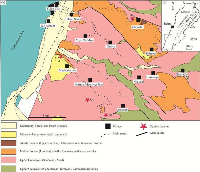
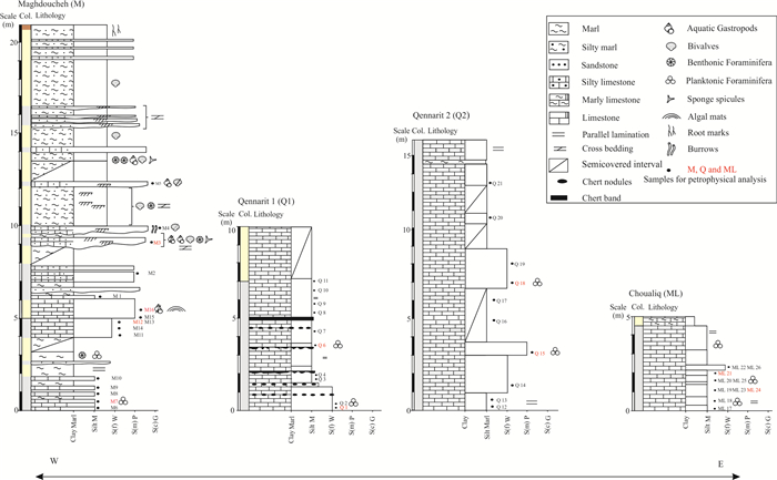
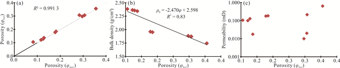
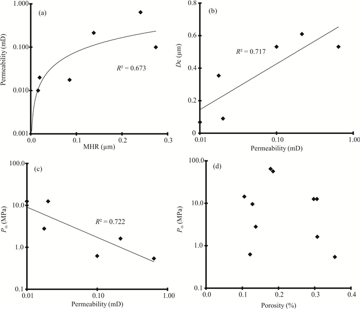
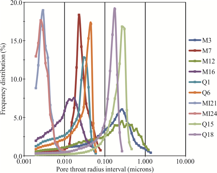
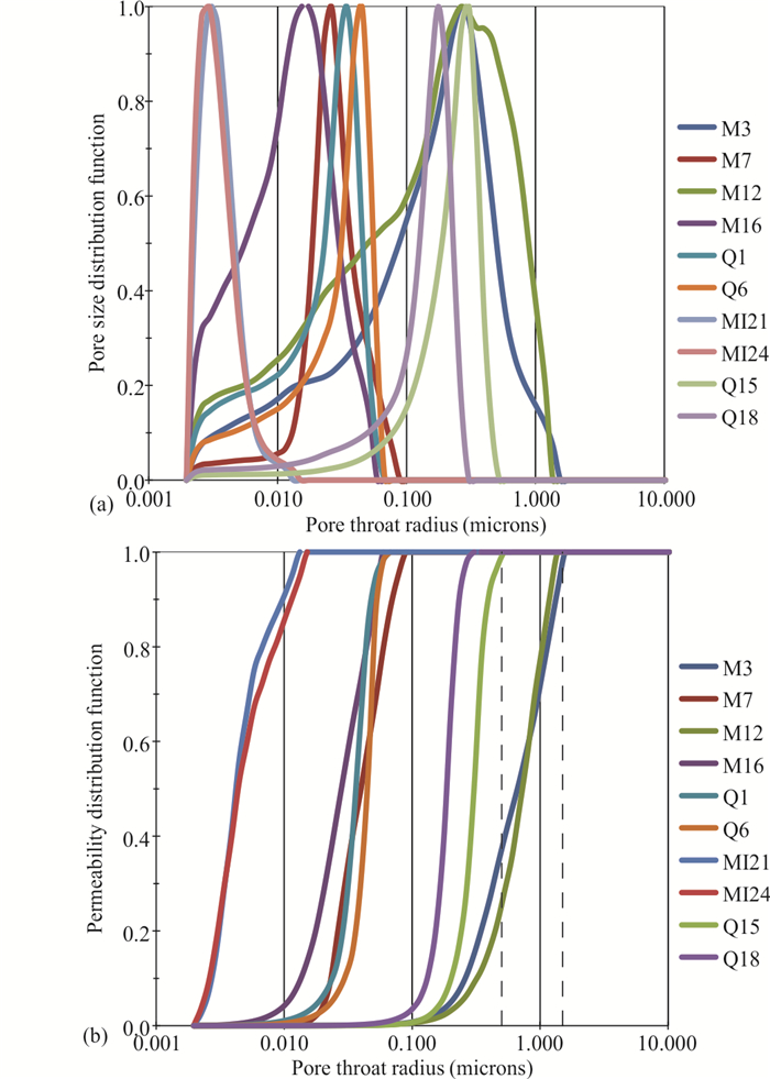
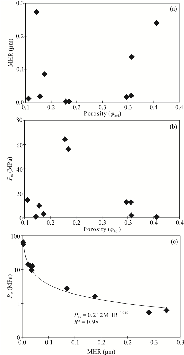
Carbonate rocks are common in many parts of the world, including the Eastern Mediterranean, where they host significant groundwater supplies and are widely used as building and ornamental stones. The porosity of carbonate rocks plays a critical role in fluid storage and retrieval. The pore structure connectivity, in particular, controls many properties of geological formations, as well as the relationships between the properties of individual minerals and the bulk properties of the rock. To study the relationships between porosity, rock properties, pore structure, pore size, and their impact on reservoir characteristics, 46 carbonate rock samples were collected from four stratigraphic sections exposed near Sidon, South Lebanon. The studied carbonate rocks are related to marine deposits of different ages (e.g., Upper Cretaceous, Eocene, and Upper Miocene). In order to understand the pore connectivity, the MICP (mercury injection capillary pressure) technique was conducted on ten representative samples. Results from the SEM analysis indicate the dominance of very fine and fine pore sizes, with various categories ranging in diameter from 0.1 to 10 μm. The MICP data revealed that the pore throat radii vary widely from 0.001 to 1.4 μm, and that all samples are dominated by micropore throats. The grain size analysis indicated that the studied rocks have significant amounts of silt- and clay-size grains with respect to the coarser 'sand-size' particles, suggesting a high proportion of microporosity. Obtained results, such as the poorly-sorted nature of grains, high microporosity, and the high percentage of micropore throats, justify the observed low mean hydraulic radius, the high entry pressure, and the very low permeability of the studied samples. These results suggest that the carbonate rocks near Sidon (south of Lebanon) are possibly classified as non-reservoir facies.

Origin and Evolution of Ultramafic Rocks along the Sagaing Fault, Myanmar
Tomoaki Morishita, Hnin Min Soe, Hla Htay, Than Htut Lwin, Juan Miguel Guotana, Akihiro Tamura, Tomoyuki Mizukami, Khin Zaw
2023, 34(1): 122-132. doi: 10.1007/s12583-021-1435-x
Abstract:

The active Sagaing fault in Myanmar defines the boundary between the Indian Plate and the Eurasian Plate and causes seismic damage in the major cities of Myanmar. Small bodies of serpentinite occur along the fault. We for the first time investigated the highly sheared serpentinite bodies in the Sheinmagar area and Yega Inn area along the Sagaing fault. Extensively sheared/brecciated serpentinites and related rocks, such as talc and/or chlorite-bearing rocks contains small rock fragments of serpentinites. Serpentine texture and mineral chemistry indicate that the protolith of these serpentinites were mainly harzburgite with minor amounts of dunite, some of which are cut by gabbroic veins. No shape-preferred orientation of the antigorite is present, indicating that the serpentinization was occurred under relatively static conditions. Protolith and serpentine minerals are similar to those of the jadeitite-bearing serpentinites in the north of the Sagaing fault (the Jade Mine belt). Chemical variations of spinels in the studied area are within the compositional range of forearc peridotites and those in the mantle section of nearby ophiolites. After the formation of antigorite serpentinite under static conditions, these serpentinites were subsequently, but locally deformed, probably due to the activity of the Sagaing fault, resulting in the formation of serpentinite schist/brecciated rock. The presence of the less-deformed antigorite serpentinite in the sheared/brecciated zone indicates the strain localization mainly along the surrounding serpentine-talc (±chlorite) schistose rocks, which is probably formed by the reaction between serpentinite and country rocks. Further studies are needed to better understand whether the distribution of serpentinized peridotites cause variations in the activity of the Sagaing fault.

Biogeology and Environmental Geology
Composition and Function of Bacterial Communities of Bryophytes and Their Underlying Sediments in the Dajiuhu Peatland, Central China
Xing Xiang, Hongmei Wang, Wen Tian, Ruicheng Wang, Linfeng Gong, Ying Xu, Baiying Man
2023, 34(1): 133-144. doi: 10.1007/s12583-020-1391-x
Abstract:

Symbiotic microbiomes of Sphagnum have been confirmed to play a fundamental role in carbon and nitrogen cycles, however, little is known about microbiomes associated with other bryophytes in subtropical peatland ecosystems. To explore the differences in community structure, metabolic potential and interaction relationship of bacterial microbiomes associated with different bryophytes species, the gametophytes of three bryophyte species (Sphagnum palustre, Aulacomnium androgynum, and Polytrichum commune) and their underlying peat sediments were collected from the subtropical Dajiuhu Peatland and subjected to Illumina high-throughout sequencing of 16S rRNA gene. Results showed that bacterial diversity was lowest in S. palustre, the dominant moss species, among the three moss species investigated in Dajiuhu Peatland. Bacterial communities from bryophytes clearly separated with those from sediments as indicated by both phylogenetic and taxonomical approaches. Linear discriminant analysis effect size (LEfSe) identified 30 and 36 indicator taxa in mosses and peat sediments. Bacteroidetes, Verrucomicrobia and Thermoleophilia significantly enriched in S. palustre, A. androgynum and P. commune, Chloroflexi, Proteobacteria and Acidobacteria subgroup 6 was indicator taxa for corresponding underlying sediments, respectively. Despite of these differences in compositions, bacterial functional structures were similar among all bryophytes, such as abundant aerobic heterotrophs, rare nitrifiers and denitrifiers. This phenomenon was also observed among the underlying sediments. Network analysis indicated that Proteobacteria and Acidobacteria located in the center of network and exerted strong interactions to other taxa. The sub-network of bacterial communities in sediments was more connected and microbial groups were more competitive than those in bryophytes sub-network. Our results offer new insight into the community structure, ecological function and interaction pattern of bacterial microbiomes in the Dajiuhu Peatland across different habitats.

Influence of CO2/HCO3- on Microbial Communities in Two Karst Caves with High CO2
Jiyu Chen, Qiang Li, Qiufang He, Heinz C. Schröder, Zujun Lu, Daoxian Yuan
2023, 34(1): 145-155. doi: 10.1007/s12583-020-1368-9
Abstract:

There is limited knowledge about microbial communities and their ecological functions in karst caves with high CO2 concentrations. Here, we studied the microbial community compositions and functions in Shuiming Cave ("SMC", CO2 concentration 3 303 ppm) and Xueyu Cave ("XYC", CO2 concentration 8 753 ppm) using Illumina MiSeq high-throughput sequencing in combination with BIOLOG test. The results showed that Proteobacteria, Actinobacteria and Bacteroidetes were dominant phyla in these two caves, and Thaumarchaeota was the most abundant in the rock wall samples of SMC. The microbial diversity in the water samples decreased with increasing HCO3- concentration, and it was higher in XYC than that in SMC. The microbial community structures in the sediment and rock wall samples were quite different between the two caves. High concentrations of CO2 can reduce the microbial diversity on the rock walls in karst caves, probably through changing microbial preference for different types of carbon sources and decreasing the microbial utilization rate of carbon sources. These results expanded our understanding of microbial community and its response to environments in karst caves with high CO2.

Composition and Construction of High- and Low-Energy Ooid Shoals and Their Relationships with Environmental Changes: A Case Study from the Cambrian Zhangxia Formation in the Ordos Basin, North China
Zhen Wang, Yiming Gong
2023, 34(1): 156-172. doi: 10.1007/s12583-020-1097-0
Abstract:

On the basis of systematic study of sedimentary facies, microfacies and geochemistry of measured strata sections and wells, the ooid shoals of the Cambrian Miaolingian Zhangxia Formation in the southern Ordos Basin are composed of both high- and low-energy ooid shoals. The characteristics of the high-energy shoals are sparry cementation, with moderate to well sorting, large grain size, high ooid content and low micrite, weak micritization, and well-preserved internal textures of the ooids. Macroscopically, the high-energy ooid shoals display a thick-bedded aggradational stacking pattern in upward coarsening and thickening sequences. The low-energy ooid shoals are mainly made up of micritic cementation, with moderate to poor sorting, relatively small grain size, lower ooid content and higher micrite, strong micritization, and poorly-preserved internal textures of the ooids. Macroscopically, the low-energy ooid shoals show a thin-bedded, interbedded stacking pattern in upward fining and thinning sequences. The sedimentological evidence and carbon isotope data show that the differences of internal fabric and sedimentary evolution of both high- and low-energy ooid shoals are closely related to the sea-level change.

Orbital and Millennial-Scale Climate Variability over the Past 76 ka in the Western Tarim Basin, Northwest China
Rui Zhang, Qiuzhen Yin, Weihua Nai, Zhixiang Wang, Hao Lu, Chunju Huang, Yansheng Gu, Lin Li, Yusong Wang, Linjing Liu
2023, 34(1): 173-180. doi: 10.1007/s12583-020-1115-2
Abstract:

Paleoclimate changes during the last glacial in the arid central Asia are not as well understood as the monsoon-dominated areas of Asia. Here we report a 75-m-long sediment core over past 120 kyr based on astronomical tuning combined with the optically stimulated luminescence (OSL) dating in the Kashi depression of the western Tarim Basin, Northwest China. Analysis of grain size and high-resolution gamma ray (GR) logs from the KT11 borehole across the last glacial period yields a climate history for the Tarim Basin which reflects the variations of its temperature and the hydrological cycles. Comparison of these records with north hemisphere summer insolation, the Greenland ice core temperature, stalagmites and the loess from the nearby region indicates that the deposits in the fluvio-lacustrine system of the Kashi depression responded to climate change at the Younger Dryas (YD), six Heinrich cooling events and the Dansgaard-Oeschger cycles. Our work indicates that the alternations between warm-humid and cold-dry climates were prevalent in the western Tarim Basin during the last glacial period, showing an in-phase pattern with the climate variations of the East Asian Monsoon, controlled ultimately by precession and North Atlantic Ocean climate variability on orbital-millennial time scales.

Springs Emerging along the Elevation Gradient Indicate Intensive Groundwater-Surface Water Exchange in an Alpine Headwater Catchment, Northwestern China
Yalu Hu, Ziyong Sun, Rui Ma
2023, 34(1): 181-193. doi: 10.1007/s12583-021-1548-2
Abstract:

Groundwater plays an important role in sustaining the streamflow in cold alpine area, but is poorly understood due to a lack of direct access. About 98 groups of springs are observed at the upper reaches of Heihe River Basin, which provide an opportunity to explore the main aquifers. Springs are clustered in three groups according to locations: (1) springs on the moraine and talus deposits; (2) springs at the end of alluvial plain in lower topography; (3) springs along the river bank. The hydrometric, geochemical and isotopic data of springs in a representative catchment were integrated and used to elucidate the groundwater flow paths. Results indicate the Quaternary porous aquifers in the alpine catchment have a profound influence on the regional groundwater flow paths and the groundwater and surface water (GW-SW) interactions. The aquifer consisting of alluvial-pluvial deposits has a great capacity of groundwater storage and plays a vital role in regulating discharge by attenuating the seasonal variation and maintaining the main stream in cold seasons. This is different from the fast recharge and discharge mode of the moraine and talus deposits. Our work highlights the importance of loose deposits in controlling the GW-SW interactions in the cold alpine area.

Crustal Thermo-Structure and Geothermal Implication of the Huangshadong Geothermal Field in Guangdong Province
Zhicai Xiao, Shuai Wang, Shihua Qi, Jian Kuang, Min Zhang, Hailong Li
2023, 34(1): 194-204. doi: 10.1007/s12583-021-1486-z
Abstract:

Dense distribution of granites and surrounding hot springs, the high anomalous heating rates of geothermal fluids and the high geothermal gradients in shallow crust in Southeast China are revealed by previous geothermal explorations. However, there have always been debates on the genesis of geothermal anomalies of Southeast China. It is imperative to look into the genesis mechanism of geothermal anomalies through selecting a typical geothermal field, and constructing fine crustal thermo-structure. In this study, in-depth excavation is implemented for the previous data of geophysical exploration and deep drilling exploration in the Huangshadong area. We synthetically analyze the results of radioactive heat productions (RHPs), thermophysical properties of rocks and audio-frequency magnetotellurics (AMT) sounding. This study concludes that the coefficient of radioactive heat generation (RHG) of crustal rocks and conduction heat of concealed granites is the main formation mechanism of geothermal anomalies of South China, where occurs a Great Granite Province. There is a regional indicating implication for the genesis of geothermal anomalies, taking the Huangshadong geothermal field as a typical example. It is also an important reference to guide the exploration, evaluation, development and utilization of geothermal resources in this region.

Analysis of the Hydraulic and Heat Transfer Evolution Mechanism of a Single Rock Fracture
Biao Shu, Fan Zeng, John Kemeny, Runjun Zhu, Keping Chen, Jingqiang Tan
2023, 34(1): 205-213. doi: 10.1007/s12583-022-1648-7
Abstract:

Mineral dissolution and mechanical deformation of granite are two main mechanisms that affect permeability evolution of rock fracture. In this study, two water flow-through experiments with large granite fractures were conducted at 200 ℃ with a constant flow rate for 24 h, under confining pressures of 5 and 10 MPa, respectively. Water pressure and temperature were measured, fracture aperture and permeability were calculated, and chemical element concentrations in effluent water were tested for mechanism analysis. The permeability fluctuates up and down between 2.62 × 10⁻¹² and 3.16 × 10⁻¹² m2 at confining pressure of 5 MPa; while it decreased monotonously by 24% from 1.92 × 10⁻¹² to 1.45 × 10⁻¹² m2 at a confining pressure of 10 MPa. The heat transfer rates at both experiments stay stable at about 0.25 J/s. The mass concentration of Ca, Na, K, and Si in effluent water are between 5 to 23 mg/L, indicating slight dissolution of Ca-plagioclase, Na-plagioclase, and K-feldspar, as well as possible precipitation of minor amount of kaolinite or quartz. The total amount of free-face dissolution and pressure dissolution are similar at 5 and 10 MPa. The geochemical reaction counts for only small part of the aperture change, while the mechanical deformation counts the major part of the aperture change.

Anthropogenic Pseudokarstic Depressions on Mount Bocskor (Bakony Region, Hungary)
Márton Veress, Zoltán Unger, Szilárd Vetési-Foith
2023, 34(1): 214-231. doi: 10.1007/s12583-021-1506-z
Abstract:

Surface forms above the mine (Ármin mine) of Mount Bocskor (Southern Bakony, Hungary) were examined. We made contour maps, plan maps, morphological maps and atectonic grike (cave) maps of some of the forms and their surroundings. We examined the distribution of the depth, length, elongation ratio in case of some depressions, the relation between the depth and the diameter of some depressions, the relationship between depression group directions and mine cut directions, the standard deviation of the direction differences of depression groups and of their depressions. The forms of the mountain related to surface mining can be separated to open and closed. The former are trenches and stairs, the latter are circular, elongated, and complex depressions. The formation of these forms can be related to the balancing movements of the vault over the mountain's mine. At thin vault, stairs develop by collapses, while at the atectonic fissures of thicker vault, trenches and depressions are formed at the surface. In areas bordered by sinking (subsidence through) and downwardly cohesive faults, depression groups of diverse features are arranged in the marginal bands. Elongated depressions are formed at atectonic blocks bounded by dispersing faults in non-banded distribution. Where there is a superficial deposit, atectonic fissures can also be inherited directly by collapse to the surface and form depressions. They can also form indirectly over atectonic fissures by compaction, subsequent collapse and/or suffosion of the superficial deposit. The results of the study make it possible to analyse the material loss due to mining on the vault if the atectonic structures of the vault are partly or completely covered by superficial deposit.

Petroleum and Stratigraphy
Recognition and Prediction of Source Rocks of the Madingo Formation in the Lower Congo Basin
Youran Yang, Xianghua Yang, Wanzhong Shi, Hongtao Zhu, Wei Wang, Hongquan Kang, Linan Pang
2023, 34(1): 232-241. doi: 10.1007/s12583-020-1354-2
Abstract:

We investigated the petrological and seismic properties of Madingo Formation, the high-quality source rocks in the Madingo Formation in the Lower Congo Basin are highly heterogeneous. Due to little drilling and oil-based mud pollution, samples that are able to be used to measure the TOC (total organic carbon) content of source rock in the Madingo Formation are few and unevenly distributed; hence, it is difficult to carry out their quantitative evaluation. We investigated the petrological and seismic properties of Madingo Formation between TOC and well logging parameters including density, natural gamma, and acoustic time difference via multiple regression analysis. The TOC data volume is calculated using a neural network model between the predicted TOC content and seismic attributes of the sidetrack. The results of TOC three-dimensional quantitative prediction in the study area show that the source rocks in the Madingo Formation have a strong heterogeneity in the vertical direction, and the plane distribution is low in the northeast and high in the southwest. This study provides suitable tools to predict the complex heterogeneous distribution of source rocks and has great significance for oil exploration in the Lower Congo Basin.

Facies Associations and Sequence Stratigraphy of the Toarcian Marrat Formation (Saudi Arabia) and Their Equivalents in Some Gondwanaland Regions
Mohamed Tawfik, Abelbaset S. El-Sorogy, Khaled Al-Kahtany
2023, 34(1): 242-259. doi: 10.1007/s12583-020-1379-6
Abstract:

The Toarcian Marrat Formation is exposed in outcrops in central Saudi Arabia and displays a variety of clastic and carbonate facies associated with well-preserved depositional geometries. It is unconformably overlies the Triassic Minjur Formation and it in turn is overlaid by the Middle Jurassic Dhruma Formation. Thirteen lithofacies types can be identified that permit the recognition of five lithofacies associations in a mixed clastic/carbonate platform. These lithofacies range from low-energy peritidal, intertidal, and back-shoal to moderate- and high-energy shoal and foreshoal lithofacies associations. The Marrat Formation exhibits three depositional sequences, each sequence is grouped into a transgressive systems tract (TST) and a highstand systems tract (HST) and then bounded by sequence boundary surfaces (SBSs). The TSTs are generally identified in clastic tidal-flat beds and back-shoal wackestones, while the HST is generally recorded in the carbonate tidal-flat and shoal. The vertical succession of facies associations from peritidal to foreshoal depositional environments is indicative of a deepening upward and retrogradational systems tract, from Lower to Upper Toarcian. The correlation between the studied sections reveals a general shallowing towards the south and the similarities between the studied sequences and others in the Arabian Gulf, the northern Neo-Tethys Plate, and Gondwanaland countries.

Applied Geophysics
Possible South-Dipping Mesozoic Subduction at Southern Tethys Ocean-Constrained from Global Tectonic Reconstructions and Seismic Tomography
Peilong Yan, Nan Zhang, Huaiyu Yuan, Liang Qi, Xiaoxu Liu
2023, 34(1): 260-279. doi: 10.1007/s12583-021-1466-3
Abstract:

The evolution of the Tethys Ocean involved several episodes of ocean opening (including the Paleo-Tethys and Neo-Tethys) along its southern margin as terranes rifting away from eastern Gondwana. These oceans were terminated by well observed north-dipping subduction as the same terranes accreted to southern Eurasia. However, the presence of south-dipping subduction, though geologically proposed by numerous studies, have generally been omitted in the reconstruction of Tethyan evolution. Here, we synthesize the Mesozoic south-dipping subduction evolutions in the global reconstruction and focus on two potential events located along the northern edges of Southwest Borneo Block and the Woyla Arc. We next evaluate their slab volumes after thermal diffusion in the current mantle. Fast velocity anomalies in the mantle beneath the same region are then converted to cold anomalies and their volumes are further estimated and compared to the volumes evaluated from these two Mesozoic south-dipping subduction. We further identify seismic fast velocity anomalies likely relevant to slab remnants of south-dipping Tethyan subduction in the present-day mantle beneath the Indian ocean and West Australia, and link them to arc systems in plate reconstructions. In addition, one more tectonic scenario relevant to the north-dipping subduction in our study region is also examined. We speculate the relationship and evolution between such south-dipping subduction and north-dipping subduction in the south of Tethys Oceans. The attempt to reconstruct intermittent south-dipping subduction systems in southern Tethys region represents an effort on assessing rifting mechanisms in the opening of the Tethys Ocean and break-up of eastern Gondwana.

Upper-Mantle Velocity Heterogeneity of Eastern Tibetan Plateau from Teleseismic P-Wave Tomography and Its Tectonic Implications
Shahpara Sheikh Dola, Junmeng Zhao, Heng Zhang, Shunping Pei
2023, 34(1): 280-290. doi: 10.1007/s12583-021-1478-z
Abstract:

An attempt has been made to reveal the upper mantle velocity structure of the eastern Tibetan Plateau using 628 teleseismic events recorded from 2003 to 2009 at 95 stations. A total of 8 532 P-wave arrival time residuals were inverted by using the FMTOMO (fast marching tomography) software package. Tomographic results show upper mantle velocity heterogeneity in many aspects. In the southern part visible high velocity anomaly is denoted as the Indian lithosphere. This part seems to be affected by slab tearing at 94°E longitude as it is located on the eastern Himalayan syntaxis (EHS). The high velocity zone down to 500 km depth in the northern part could be the Asian lithosphere. At the central part some high velocity anomalies can be identified as detached patches of the lithosphere, surrounded by low velocity anomalies. These anomalies are the potential to create thermal convection and trigger plateau uplift or plateau growth. Sudden velocity change occurs on both sides of patches where low velocity anomaly is visible in between patches and Bangong-Nujiang suture even in between Songpan-Ganzi terrain and Asian Plate. In both cases intense low velocity zone spread down to 500 km. The depth range of low velocity anomalies in between two plates observed from 200 to ~500 km. Hence the low velocity anomalies detected in our results may reflect either the hot asthenosphere upwelling or the mantle wedge due to the presence of the cold lithosphere.