| Citation: | Yujie Long, Weile Li, Runqiu Huang, Qiang Xu, Bin Yu, Gang Liu. A Comparative Study of Supervised Classification Methods for Investigating Landslide Evolution in the Mianyuan River Basin, China. Journal of Earth Science, 2023, 34(2): 316-329. doi: 10.1007/s12583-021-1525-9

|
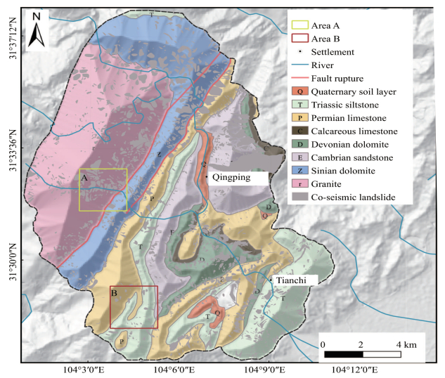
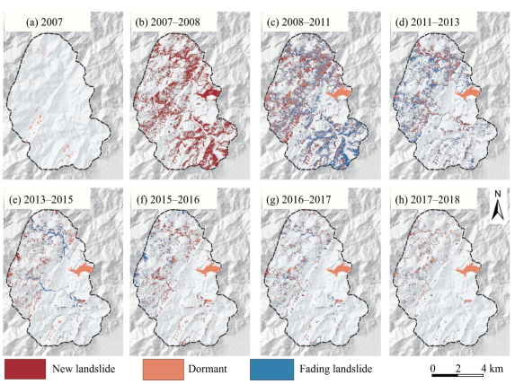
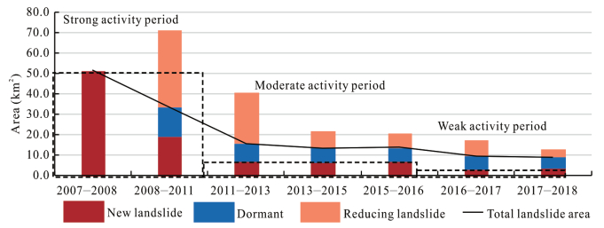
The

| Blaschke, T., 2010. Object Based Image Analysis for Remote Sensing. ISPRS Journal of Photogrammetry and Remote Sensing, 65(1): 2–16. https://doi.org/10.1016/j.isprsjprs.2009.06.004 |
| Breiman, L., 2001. Random Forests. Machine Learning, 45(1): 5–32. https://doi.org/10.1023/a:1010933404324 |
| Chen, H., Hawkins, A. B., 2009. Relationship between Earthquake Disturbance, Tropical Rainstorms and Debris Movement: An Overview from Taiwan. Bulletin of Engineering Geology and the Environment, 68(2): 161–186. https://doi.org/10.1007/s10064-009-0209-y |
| Chen, W. T., Li, X. J., Wang, Y. X., et al., 2014. Forested Landslide Detection Using LiDAR Data and the Random Forest Algorithm: A Case Study of the Three Gorges, China. Remote Sensing of Environment, 152: 291–301. https://doi.org/10.1016/j.rse.2014.07.004 |
| Chen, X., Cui, P., Li, Y., et al., 2010. Mountain Hazard Induced by Wenchuan Earthquake and Its Long-term Development Trends of Ganxi Gully, Beichuan. Journal of Sichuan University (Engineering Science Edition), 42 (S1): 22–32 (in Chinese with English Abstract) |
| Chen, Z., Zhang, Y. F., Ouyang, C., et al., 2018. Automated Landslides Detection for Mountain Cities Using Multi-Temporal Remote Sensing Imagery. Sensors, 18(3): 821. https://doi.org/10.3390/s18030821 |
|
China Earthquake Administration, 2008. Intensity Distribution Map of Wenchuan Ms 8.0 Earthquake [2008-9-1]. |
| Cui, P., Zhuang, J. Q., Chen, X. C., et al., 2010. Characteristics and Countermeasures of Debris Flow in Wenchuan Area after the Earthquake. Journal of Sichuan University (Engineering Science Edition), 42(5): 10–19 (in Chinese with English Abstract) |
| Dai, F. C., Xu, C., Yao, X., et al., 2011. Spatial Distribution of Landslides Triggered by the 2008 Ms 8.0 Wenchuan Earthquake, China. Journal of Asian Earth Sciences, 40(4): 883–895. https://doi.org/10.1016/j.jseaes. 2010.04.010 doi: 10.1016/j.jseaes.2010.04.010 |
| Dou, J., Chang, K. T., Chen, S. S., et al., 2015. Automatic Case-Based Reasoning Approach for Landslide Detection: Integration of Object-Oriented Image Analysis and a Genetic Algorithm. Remote Sensing, 7(4): 4318–4342. https://doi.org/10.3390/rs70404318 |
| Dou, J., Yunus, A. P., Tien Bui, D., et al., 2019. Evaluating GIS-Based Multiple Statistical Models and Data Mining for Earthquake and Rainfall-Induced Landslide Susceptibility Using the LiDAR DEM. Remote Sensing, 11(6): 638. https://doi.org/10.3390/rs11060638 |
| Fan, X. M., Scaringi, G., Korup, O., et al., 2019. Earthquake-Induced Chains of Geologic Hazards: Patterns, Mechanisms, and Impacts. Reviews of Geophysics, 57(2): 421–503. https://doi.org/10.1029/2018r g000626 doi: 10.1029/2018rg000626 |
| Ghorbanzadeh, O., Blaschke, T., Gholamnia, K., et al., 2019. Evaluation of Different Machine Learning Methods and Deep-Learning Convolutional Neural Networks for Landslide Detection. Remote Sensing, 11(2): 196. https://doi.org/10.3390/rs11020196 |
| Gorum, T., Fan, X. M., van Westen, C. J., et al., 2011. Distribution Pattern of Earthquake-Induced Landslides Triggered by the 12 May 2008 Wenchuan Earthquake. Geomorphology, 133(3/4): 152–167. https://doi.org/10.1016/j.geomorph.2010.12.030 |
| Guo, X. J., Cui, P., Li, Y., et al., 2016a. Intensity-Duration Threshold of Rainfall-Triggered Debris Flows in the Wenchuan Earthquake Affected Area, China. Geomorphology, 253(13): 208–216. https://doi.org/10.1016/j.geomorph.2015.10.009 |
| Guo, X. J., Cui, P., Li, Y., et al., 2016b. Spatial Features of Debris Flows and Their Rainfall Thresholds in the Wenchuan Earthquake-Affected Area. Landslides, 13(5): 1215–1229. https://doi.org/10.1007/s10346-015-060 8-z doi: 10.1007/s10346-015-0608-z |
| Guzzetti, F., Mondini, A. C., Cardinali, M., et al., 2012. Landslide Inventory Maps: New Tools for an Old Problem. Earth-Science Reviews, 112(1/2): 42–66. https://doi.org/10.1016/j.earscirev.2012.02.001 |
| Hong, H. Y., Pourghasemi, H. R., Pourtaghi, Z. S., 2016. Landslide Susceptibility Assessment in Lianhua County (China): A Comparison between a Random Forest Data Mining Technique and Bivariate and Multivariate Statistical Models. Geomorphology, 259(15): 105–118. https://doi.org/10.1016/j.geomorph.2016.02.012 |
| He, X. L., Xu, C., Qi, W. W., et al., 2021. Landslides Triggered by the 2020 Qiaojia Mw 5.1 Earthquake, Yunnan, China: Distribution, Influence Factors and Tectonic Significance. Journal of Earth Science, 32(5): 1056–1068. https://doi.org/10.1007/s12583-021-1492-1 |
| Huang, R. Q., Li, W. L., 2009. Analysis of the Geo-Hazards Triggered by the 12 May 2008 Wenchuan Earthquake, China. Bulletin of Engineering Geology and the Environment, 68(3): 363–371. https://doi.org/10.1007/s10064-009-0207-0 |
| Huang, R. Q., Li, W. L., 2014. Post-Earthquake Landsliding and Long-Term Impacts in the Wenchuan Earthquake Area, China. Engineering Geology, 182: 111–120. https://doi.org/10.1016/j.enggeo.2014.07.008 |
| Huang, Y. D., Xu, C., Zhang, X. L., et al., 2021. An Updated Database and Spatial Distribution of Landslides Triggered by the Milin, Tibet Mw 6.4 Earthquake of 18 November 2017. Journal of Earth Science, 32(5): 1069–1078. https://doi.org/10.1007/s12583-021-1433-z |
| Ji, S. P., Yu, D. W., Shen, C. Y., et al., 2020. Landslide Detection from an Open Satellite Imagery and Digital Elevation Model Dataset Using Attention Boosted Convolutional Neural Networks. Landslides, 17(6): 1337–1352. https://doi.org/10.1007/s10346-020-01353-2 |
| Jin, W., Zhang, G., Zou, Q., et al., 2019. A New Understanding of the Activity Behavior of Post-Earthquake Debris Flow—Taking the "8· 20" Event in Wenchuan, Sichuan, China as an Example. Mountain Research, 37 (5): 787–796 (in Chinese with English Abstract) |
| Lacroix, P., Zavala, B., Berthier, E., et al., 2013. Supervised Method of Landslide Inventory Using Panchromatic SPOT5 Images and Application to the Earthquake-Triggered Landslides of Pisco (Peru, 2007, Mw 8.0). Remote Sensing, 5(6): 2590–2616. https://doi.org/10.33 90/rs5062590 doi: 10.3390/rs5062590 |
| Lee, S., Lee, M. J., 2006. Detecting Landslide Location Using KOMPSAT 1 and Its Application to Landslide-Susceptibility Mapping at the Gangneung Area, Korea. Advances in Space Research, 38(10): 2261–2271. https://doi.org/10.1016/j.asr.2006.03.036 |
| Li, G., West, A. J., Densmore, A. L., et al., 2014. Seismic Mountain Building: Landslides Associated with the 2008 Wenchuan Earthquake in the Context of a Generalized Model for Earthquake Volume Balance. Geochemistry, Geophysics, Geosystems, 15(4): 833–844. https://doi.org/10.1002/2013gc005067 |
| Li, L. J., Yao, X., Zhang, Y. S., et al., 2014. RS-Based Extraction and Distribution Characteristics of Geo-Hazards Trggered by Wenchuan Earthquake in Mianyuan River Basin. Journal of Engineering Geology, 22(1): 46–55 (in Chinese with English Abstract) |
| Li, W. L., Huang, R. Q., Tang, C., et al., 2011. Landslide Triggered by "5·12" Wenchuan Earthquake in the Mianyuan River Basin, China. Journal of Mountain Science, 29(4): 483–492 (in Chinese with English Abstract) |
| Li, Z. H., Zhang, C. L., Chen, B., et al., 2022. A Technical Framework of Landslide Prevention Based on Multi-Source Remote Sensing and Its Engineering Application. Earth Science, 47(6): 1901–1916 (in Chinese with English Abstract) |
| Lin, Q. G., Zou, Z. H., Zhu, Y. Q., et al., 2017. Object-Oriented Detection of Landslides Based on the Spectral, Spatial and Morphometric Properties of Landslides. Remote Sensing Technology and Application, 32(5): 931–937 (in Chinese with English Abstract) |
| Liu, P. Y., Chang, M., Wu, B. B., et al., 2022. Route Selection of Landslide Prone Area in Wenchuan Section of Chengdu-Wenchuan Expressway Based on SBAS-InSAR. Earth Science, 47(6): 2048–2057 (in Chinese with English Abstract) |
| Lu, P., Stumpf, A., Kerle, N., et al., 2011. Object-Oriented Change Detection for Landslide Rapid Mapping. IEEE Geoscience and Remote Sensing Letters, 8(4): 701–705. https://doi.org/10.1109/lgrs.201 0.2101045 doi: 10.1109/lgrs.2010.2101045 |
| Nakamura, H., Tsuchiya, S. K. I., 2000. Sabo Against Earthquakes. Tokyo, Kokon Shoin |
| Ni, Z., Yang, Z., Li, Y., et al., 2019. Decreasing Trend of Geohazards Induced by the 2008 Wenchuan Earthquake Inferred from Time Series NDVI Data. Remote Sensing, 11(19): 2192. https://doi.org/10.3390/rs11192192 |
| Nichol, J., Wong, M. S., 2005. Detection and Interpretation of Landslides Using Satellite Images. Land Degradation & Development, 16(3): 243–255. https://doi.org/10.1002/ldr.648 |
| Parker, R. N., Densmore, A. L., Rosser, N. J., et al., 2011. Mass Wasting Triggered by the 2008 Wenchuan Earthquake is Greater than Orogenic Growth. Nature Geoscience, 4(7): 449–452. https://doi.org/10.1038/ng eo1154 doi: 10.1038/ngeo1154 |
| Prakash, N., Manconi, A., Loew, S., 2020. Mapping Landslides on EO Data: Performance of Deep Learning Models vs. Traditional Machine Learning Models. Remote Sensing, 12(3): 346. https://doi.org/10.3390/rs12030346 |
| Qi, S. W., Xu, Q., Lan, H. X., et al., 2010. Spatial Distribution Analysis of Landslides Triggered by 2008.5.12 Wenchuan Earthquake, China. Engineering Geology, 116(1/2): 95–108. https://doi.org/10.1016/j.engg eo.2010.07.011 doi: 10.1016/j.enggeo.2010.07.011 |
| Sansar, M. R., Ghorbanzadeh, O., Westen, C. J., et al., 2021. Rapid Mapping of Landslides in the Western Ghats (India) Triggered by 2018 Extreme Monsoon Rainfall Using a Deep Learning Approach. Landslides, 18(5): 1937–1950. https://doi.org/10.1007/s10346-020-016 02-4 doi: 10.1007/s10346-020-01602-4 |
| Stumpf, A., Kerle, N., 2011. Object-Oriented Mapping of Landslides Using Random Forests. Remote Sensing of Environment, 115(10): 2564–2577. https://doi.org/10.1016/j.rse.2011.05.013 |
| Su, F. H., Liu, H. J., Han, Y. S., 2008. The Extraction of Mountain Hazard Induced by Wenchuan Earthquake and Analysis of Its Distributing Characteristic. Journal of Remote Sensing, 12(6): 956–963 (in Chinese with English Abstract) |
| Tang, C., 2010. Activity Tendency Prediction of Rainfall Induced Landslides and Debris Flows in the Wenchuan Earthquake Areas. Journal of Mountain Science, 28(3): 341–349 (in Chinese with English Abstract) |
| Tang, C. X., van Westen, C. J., Tanyas, H., et al., 2016. Analysing Post-Earthquake Landslide Activity Using Multi-Temporal Landslide Inventories near the Epicentral Area of the 2008 Wenchuan Earthquake. Natural Hazards and Earth System Sciences, 16(12): 2641–2655. https://doi.org/10.5194/nhess-16-2641-2016 |
| Tang, C., Liang, J. T., 2008. Characteristics of Debris Flows in Beichuan Epicenter of the Wenchuan Earthquake Triggered by Rainstorm on September 24, 2008. Journal of Engineering Geology, 16(6): 751–758 (in Chinese with English Abstract) |
| van der Linden, S., Rabe, A., Held, M., et al., 2015. The EnMAP-Box—A Toolbox and Application Programming Interface for EnMAP Data Processing. Remote Sensing, 7(9): 11249–11266. https://doi.org/10.33 90/rs70911249 doi: 10.3390/rs70911249 |
| Watts, J. D., Lawrence, R. L., Miller, P. R., et al., 2009. Monitoring of Cropland Practices for Carbon Sequestration Purposes in North Central Montana by Landsat Remote Sensing. Remote Sensing of Environment, 113(9): 1843–1852. https://doi.org/10.1016/j.rse.2009.04.015 |
| Wei, X. L., Chen, N. S., Cheng, Q. G., et al., 2014. Long-Term Activity of Earthquake-Induced Landslides: A Case Study from Qionghai Lake Basin, Southwest of China. Journal of Mountain Science, 11(3): 607–624. https://doi.org/10.1007/s11629-013-2970-4 |
| Xu, C., 2013. Automatic Extraction of Earthquake-Triggered Landslides Based on Maximum Likelihood Method and Its Validation. The Chinese Journal of Geological Hazard and Control, 24(3): 19–25 (in Chinese with English Abstract) |
| Xu, C., Xu, X. W., Yao, X., et al., 2014. Three (Nearly) Complete Inventories of Landslides Triggered by the May 12, 2008 Wenchuan Mw 7.9 Earthquake of China and Their Spatial Distribution Statistical Analysis. Landslides, 11(3): 441–461. https://doi.org/10.1007/s10346-013-0404-6 |
| Xu, Q., Zhang, S., Li, W. L., et al., 2012. The 13 August 2010 Catastrophic Debris Flows after the 2008 Wenchuan Earthquake, China. Natural Hazards and Earth System Sciences, 12(1): 201–216. https://doi.org/10.5194/nhess-12-201-2012 |
| Yu, B., Chen, F., Xu, C., 2020. Landslide Detection Based on Contour-Based Deep Learning Framework in Case of National Scale of Nepal in 2015. Computers & Geosciences, 135: 104388. https://doi.org/10.10 16/j.cageo.2019.104388 doi: 10.1016/j.cageo.2019.104388 |
| Yunus, A. P., Fan, X. M., Tang, X. L., et al., 2020. Decadal Vegetation Succession from MODIS Reveals the Spatio-Temporal Evolution of Post-Seismic Landsliding after the 2008 Wenchuan Earthquake. Remote Sensing of Environment, 236: 111476. https://doi.org/10.1016/j.rse.2019.111476 |
| Zhang, L. M., Zhang, S., Huang, R. Q., 2014. Multi-Hazard Scenarios and Consequences in Beichuan, China: The First Five Years after the 2008 Wenchuan Earthquake. Engineering Geology, 180: 4–20. https://doi.org/10.1016/j.enggeo.2014.03.020 |
| Zhu, J., Tang, C., Chang, M., et al., 2015. Field Observations of the Disastrous 11 July 2013 Debris Flows in Qipan Gully, Wenchuan Area, Southwestern China. Engineering Geology for Society and Territory, 2: 531–535. https://doi.org/10.1007/978-3-319-09057-3_88 |

Figures(10) / Tables(3)
Copyright © 2013-2020 Journal of Earth Science 鄂ICP备15021562号-2
Tel: +86-27-67885075 Fax: +86-27-67885075 E-mail: xbb@cug.edu.cn
Address: Editorial Office of Journal, China University of Geosciences, Yujiashan, Wuhan, Hubei 430074, P. R. China
Supported by:
Beijing Renhe Information Technology Co. Ltd
E-mail:
info@rhhz.net


 DownLoad: