
Citation: | Yalu Hu, Ziyong Sun, Rui Ma. Springs Emerging along the Elevation Gradient Indicate Intensive Groundwater-Surface Water Exchange in an Alpine Headwater Catchment, Northwestern China. Journal of Earth Science, 2023, 34(1): 181-193. doi: 10.1007/s12583-021-1548-2 |
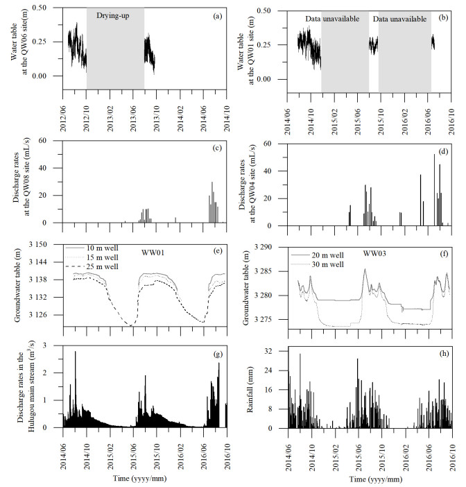
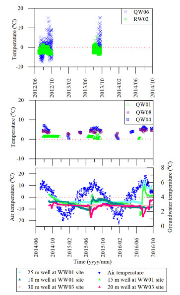
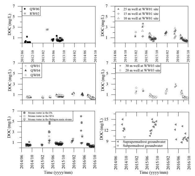
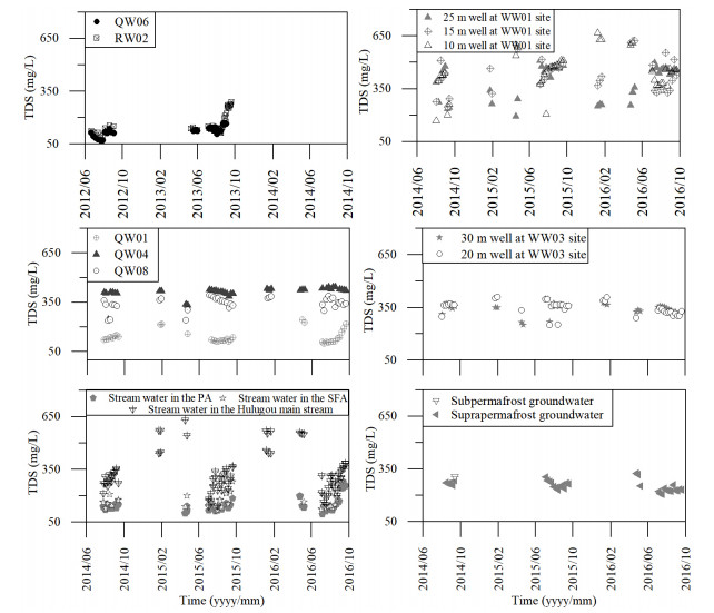
Groundwater plays an important role in sustaining the streamflow in cold alpine area, but is poorly understood due to a lack of direct access. About 98 groups of springs are observed at the upper reaches of Heihe River Basin, which provide an opportunity to explore the main aquifers. Springs are clustered in three groups according to locations: (1) springs on the moraine and talus deposits; (2) springs at the end of alluvial plain in lower topography; (3) springs along the river bank. The hydrometric, geochemical and isotopic data of springs in a representative catchment were integrated and used to elucidate the groundwater flow paths. Results indicate the Quaternary porous aquifers in the alpine catchment have a profound influence on the regional groundwater flow paths and the groundwater and surface water (GW-SW) interactions. The aquifer consisting of alluvial-pluvial deposits has a great capacity of groundwater storage and plays a vital role in regulating discharge by attenuating the seasonal variation and maintaining the main stream in cold seasons. This is different from the fast recharge and discharge mode of the moraine and talus deposits. Our work highlights the importance of loose deposits in controlling the GW-SW interactions in the cold alpine area.
The important sources of many major rivers in the world, alpine headwater area produces almost 30% of the global discharge (Penna et al., 2016; Meybeck et al., 2001), such as the Amazon River sourcing from the Andes Mountains, the Yellow and Yangtze rivers originating from the Qinghai-Tibet plateau, and the Mississippi River flowing from the Rocky Mountains. In the arid and semi-arid areas, the percentage of water from alpine headwater area can increase to 50%–90% (Viviroli et al., 2011; Viviroli and Weingartner, 2004), and the water feeds millions of people and maintains the ecosystems in the downstream reaches (Jones et al., 2018; Viviroli et al., 2011). Understanding the hydrological processes of alpine headwater catchments is essential for the scientific water resource management in the arid and semi-arid areas. Surficial deposits in the alpine headwater catchments are characterized by the coarse-grained nature and locating on steep slopes (Muir et al., 2011; McClymont et al., 2010). These features lead to the common assumptions that the deposits have little water-storage capacity and water moves rapidly through the subsurface and shallow sediments, and deep drainage is restricted by the extensive bedrock and permafrost layer (Woo, 2013).
Recent hydrological studies have demonstrated that the contribution of groundwater to alpine stream can be as large as, if not larger than, that from the surface runoff (Chang et al., 2018; Harrington et al., 2018; Hood and Hayashi, 2015; Andermann et al., 2012; Hood et al., 2006). Chang et al. (2018) had reported that the baseflow contributions to stream in the Hulugou catchment was as high as 55% during warm seasons in a year. In a study of Himalayan region, Andermann et al. (2012) claimed that deep groundwater accounts for 20% of stream flow. In a Canadian alpine watershed, the percentage of groundwater contributions to the total outflow for the 2004 and 2005 field seasons was at least 30%–67% and 35%–74%, respectively, according to Hood et al. (2006). Groundwater is even more important in semi-arid and arid cold alpine catchments, considering that groundwater sustains river base flow during long-lasting dry periods (Barberá et al., 2018; Andermann et al., 2012).
Recent research ascribed this high groundwater contribution to the coarse deposits composed of moraines, rock glaciers, and talus in alpine regions (Winkler et al., 2016; Hood and Hayashi, 2015; Kobierska et al., 2015; Clow et al., 2003; ). Clow et al. (2003) indicated that talus slopes are the primary groundwater reservoir, with a maximum storage capacity being equal to, or greater than, total annual discharge from the basin; and groundwater from talus could account for over 75% of streamflow during storms and the winter baseflow period in an alpine catchment in the Front Range of the Colorado Rocky Mountains. Hood and Hayashi (2015) demonstrated that the groundwater in proglacial moraine is critical in sustaining the aquatic ecosystem in an alpine watershed in the Canadian Rockies. Winkler et al. (2016) suggested that the relict rock glaciers with high storage capacity have an impact on water resource management in an alpine catchment in the Schöneben Rock Glacier.
Despite the intensive attentions on the groundwater in the alpine area, most studies to date have focused on the extensive proglacial moraine deposits and talus, which mainly consist of cobbles and boulders deposited by the glacier and rockfall. Relatively, few studies have examined the hydrological functioning of alluvial-pluvial deposits commonly located between the stream channel and the glacier deposits/talus, in the piedmont plain and the riparian zone. The alluvial-pluvial deposits are often characterized by poorly sorted, subangular, mud-bearing pebble gravels with moderate-large pores, and act as a hydrological buffer (Ma et al., 2017; Penna et al., 2016; McClymont et al., 2010), which have different hydrological behaviors with moraine and talus deposits. On the other hand, water from hillslopes must pass through the riparian corridor before coming to streamflow (McGlynn and McDonnell, 2003). This means the dynamic of groundwater in the deposits will more efficiently influence the temperature, geochemistry and hydrometric dynamics of streamflow (Ge et al., 2018; Roy et al., 2011). It is important to characterize how the moraine deposits-talus-alluvial-pluvial deposits complexes regulate groundwater discharge in alpine catchments (Laudon et al., 2004; Liu et al., 2004).
Springs emerge out at the local groundwater discharge zone and act as the headwater streams in the catchment (Lauber et al., 2014; Fetter, 2001). The perennial and intermittent springs provide opportunities for understanding the characterization of groundwater flow components and the groundwater responses to hydrological events (Barberá et al., 2018; Pauritsch et al., 2017; Manga, 1999). The springs also can act as an indicator of groundwater and surface water (GW-SW) interactions, especially in remote areas without hydrometric data of groundwater. Knowledge about the formation of springs and the hydrological function of porous deposits would be helpful for the accurate estimation of hydrological runoff in alpine headwater catchments.
The Heihe River is the second largest inland river in China and is generally recharged by the groundwater from the Qilian Mountains at the northeastern Qinghai-Tibet Plateau (Wei et al., 2018; Duan et al., 2017; Cheng and Jin, 2013). About 98 groups of springs are observed at the upper reaches of Heihe River Basin (Fig. 1a), which provide a good opportunity to explore groundwater flow paths. These springs are grouped into three categories depending on geographic locations: (1) springs on the moraine and talus deposits; (2) springs at the end of alluvial plain in lower topography; (3) springs along the river bank. These springs generally emerge out from the Quaternary aquifers, indicating the importance of the aquifers in controlling groundwater flow paths. In order to reveal the internal structures of the aquifers, the hydrometric data, isotopic and geochemical data of springs along the elevation gradient in a typical catchment in the headwater of the Heihe River were delineated. The ultimate objective is to develop a conceptual model of porous aquifers hydrogeology and improve the understanding of hydrological functions of porous aquifers and the ubiquitous landforms on the Qinghai-Tibet Plateau.
The Hulugou catchment (38°12'14"–38°16'23"N, 99°50'37"–99°53'54"E) is a typical alpine headwater catchment in the Heihe River with a drainage area of 23.1 km2 at an elevation of 2 960–4 820 m above sea level (a.s.l.). The catchment has a continental semiarid climate, characterized by warm, rainy summers and cold, and dry winters. The annual precipitation ranges from 400 to 600 mm, and 70% of precipitation occurs from July to September with only one discharge peak every year. The annual potential evaporation is approximately 1 100 mm. The annual mean air temperature ranges from -25.2 to 25.8 ℃ and peaks in August (Chen et al., 2014).
This catchment is a topographically closed basin and is featured with funnel like shape. High mountains occur on the south side, and the east and west sides are surrounded by steep hillslopes, and a slightly sloping alluvial plain occurs in the middle and extents to the north gorge (Ma et al., 2017). Bedrock in the southern mountains is mainly composed by lower Ordovician interbedded metasandstone and slate (Xu et al., 1989). The bedrock on the north and middle slopes are mainly made up of Permian–Cretaceous complexes, including shales with limestone and sandstone (Xu et al., 1989). Geologic faults occur at the foot of mountains and result in the bedrock outcrops (Fig. 1b).
The thickness of overlying sediments on the bedrock ranges from a few meters to tens of meters, which have been described in detail by Chang et al. (2018) and Ma et al. (2017). Briefly, coarse sediments in U-shaped valleys, and cirques in the periglacial zone primarily consist of Late Quaternary moraine deposits, which have good connectivity and poor water storage capacity. The sediments on the planation surfaces at the top of hills, generally distributed at the upper reaches of the east tributary, are composed of poorly sorted, subangular, mud-bearing gravels. The permafrost area (PA) is generally located in the southern mountains with the elevation above 3 400 m a.s.l. (Ma et al., 2017). The thickness of perennial frozen layer extends from 2 to 20 m below ground surface. The western dry channel located at the headwater area of the west tributary, is covered by thick and overburden moraine and talus deposits, extending to the top of the alluvial plain, which is featured with high hydraulic conductivity (Ma et al., 2017). The sediments on the alluvial plain and in the riparian zone along the north gorge in the seasonally frozen area (SFA) is primarily composed of poorly sorted, sub-angular and mud-bearing pebbles and gravels with middle-large pores. This layer is supposed to be favorable of water storing and flow regulation.
East and west tributaries are the two main streams in the catchment, and originate from the southern mountains and converge at the base of the alluvial plain and flow into the Hulugou main stream in the north gorge. Both of these two tributaries are recharged by glacier-snow meltwater and become dry in the cold seasons. Four groups of springs occur in the Hulugou catchment. The spring at the QW06 site represents the group of springs that emerges out in the periglacial zone from the coarse moraine deposits (Figs. 1b and S1a). This spring is interment and drains only in the warm seasons. The spring at the QW01 site is perennial and located in west tributary, and emerges out from moraine and talus deposits (Figs. 1b and S1b). At the base of alluvial plain, a cluster of springs (at the QW08 site) emerge out along the outcrop of bedrock and recharge to the main stream (Figs. 1b and S1c) and persist throughout the year. Another group of perennial springs (QW02, QW03, QW04 and QW05) issue out from the alluvial deposits along the Heihe River bank at the catchment outlet, which are located 20, 40, 80 and 150 m away from the catchment outlet, respectively (Figs. 1b and S1d).
Because of the poor infrastructure construction and harsh field environment, the monitoring and sampling work at different sites was conducted in different years. The field work in the periglacial zone was carried out from 2012 June to 2013 September, and the field work in the other part of the catchment was conducted from 2014 June to 2016 September. The comparison of data from different years is on the assumption that the inter-annual variations in physical and geochemical parameters for the same site are minor.
The nested wells were drilled at three sites in 2014 summer. The WW01 and WW03 sites are situated in the alluvial plain in the SFA. There are three wells at the WW01 site with the screen depth of 25, 15 and 10 m and two wells at the WW03 site with the screen depth of 30 and 20 m. The WW04 site is located in the PA and has two wells with the screen depth of 24.3 and 1.5 m (Fig. 1b).
Groundwater table at the WW01 and WW03 sites, water table of springs and streamflow, and water temperature of groundwater and stream water were measured using electronic pressure and temperature sensors (HOBO U20-001-02 water level logger; Onset, Bourne, MA, USA) at the 30-min interval. To calculate the water table depth with different pressure between water and atmospheric pressure, atmospheric pressure was measured simultaneously using a barometric pressure sensor (S-BPB-CM50; Onset, Bourne, MA, USA). The stream discharge was measured by constructing the water stage-discharge rating curve of a gauging station at the catchment outlet. The discharge rates of springs at the QW02–QW05 and QW08 sties were estimated by the product of flow rate and the area of flow cross section, and the flow rate was manually obtained by measuring the movement of a float per second. The water temperature of spring water at the QW02–QW05 and QW08 sties was manually measured. The discharge rates of springs at the QW01 and QW06 sites were hard to quantify due to lack of gauging station and the water table at the spring outlet was applied to represent the discharge rates.
The precipitation and air temperature data were collected at 30-min interval using a TRwS 500 (MPS, Slovakia) in the weather station in the alluvial plain (38°14'54"N and 99°52'36"E) and the daily precipitation was calculated (Chen et al., 2014).
Well groundwater, spring water, stream water, snow meltwater and glacier-snow meltwater were sampled for major ions and δ2H, δ18O and 3H isotope analysis. Stream water at the RW02 site, spring water at the QW06 site and glacier-snow meltwater, were collected during 2012 and 2013 summer every week (Fig. 1b). As the stream water at the RW02 site was mainly recharged by spring water emerging out from the moraine deposits, the features of the stream water were supposed to be comparable with that of spring water at the QW06 site. Weekly rainfall samples were collected at the rainfall sampling sites (Fig. 1b) with elevations from 2 962 to 3 552 m a.s.l. during the warm seasons (from June to September) between 2014 and 2016. The snow meltwater was sampled two times in January 2015 at the rainfall sampling sites (Fig. 1b). Stream water samples were primarily collected in the east tributary and in the Hulugou main stream, including three sites in the PA, and four sites in the SFA (Fig. 1b). Stream water, spring water and groundwater at the WW01, WW03 and WW04 sites were collected 3–4 times in January and 3–4 times in April, and were sampled weekly in the warm seasons from 2014 to 2016.
Temperature, electrical conductivity (EC) and pH values of water sample were measured by the portable meter (Hach HQ40d). Prior to sampling work, the wells were pumped continuously for 15 mins until the EC readings stabilized. Aliquots for major ions analysis and 3H isotope analysis were collected in polyethylene vials without headspace. The samples for hydrogen and oxygen isotope measurements were preserved in glass vials and the samples for dissolved organic carbon (DOC) concentrations were preserved in pre-combusted glass bottles, respectively, sealed with airtight caps. Bottles were thrice rinsed with sample water before collecting. Samples for major ions and isotope analysis were filtered through 0.22 μm polycarbonate filters and aliquots for DOC concentrations were filtered through 0.45 μm pre-combusted glass filters shortly after collection. Samples used for major cations analysis were acidified to a pH ≤ 2 with ultrapure HNO3. All samples were preserved below 4 ℃ until analysis.
Alkalinity measurements were performed using the Gran titration method with unfiltered samples in 24 h. The analysis of water samples was conducted within two months after sampling at the Laboratory of Basin Hydrology and Wetland Eco-restoration, China University of Geosciences, Wuhan, China. Major anions (Cl-, SO42- and NO3-) analysis was performed using a Dionex ICS 1100 ion chromatograph. Major cation analysis was performed using inductively coupled plasma-atomic emission spectroscopy (IRIS INTRE II XSP). Values of 18O and 2H stable isotopes were determined using a Picarro L2130-i analyzer, and compositions were expressed based on the δ (per mil) ratio with respect to the Vienna standard mean ocean water (V-SMOW). The analytical precisions of δ18O and δ2H were 0.025‰ and 0.1‰, respectively. The dissolved organic matter (DOC) concentrations were analyzed by TOC analyzer (Aurora 1030W TOC, OI, the United States) with the analytical precisions 2 ppb C. The measurement uncertainty was determined using repeating analysis of samples and standards, and analysis precision was controlled within 2%. A total of 13 well groundwater and spring water samples were analyzed for 3H concentrations. The radioactive isotope data used in this study had been described elsewhere by Ma et al. (2017) and was used here only to help provide an explanation about the groundwater transit time.
The stable isotope measurements may be used for estimating the mean elevation of the recharge area of springs (Poage and Chamberlain, 2001; Siegenthaler and Oeschger, 1980).
H=Hr+(δ−δr)/gradδ |
(1) |
Hr and δr are the elevation and δ18O values of reference rainfall samples near the sampling sites. H and δ are the recharge elevation and isotope values of spring samples, respectively. The δ18O value at a specific site is the means over whole period of observation. The gradδ is the corresponding δ18O gradient that decreases with elevation, which is about -0.3‰/100 m for precipitaiton in the Hulugou catchment according to previous sampling work (Chang et al., 2018; Ma et al., 2017).
Results show that the proglacial spring at the QW06 site dried up in the cold seasons and the lowering of water table was observed from August to October (Fig. 2). The spring at the QW01 site persisted throughout the year and the water table of outflow decreased from summer to winter (Fig. 2). According to previous work, the springs at the QW02–QW05 sites showed similar discharge and hydrogeochemical features (Hu et al., 2019; Ma et al., 2017); therefore, in the following description, only the features of spring at the QW04 site were shown to represent the group of springs located at the catchment outlet. The manually measured discharge rates of spring at the QW04 and QW08 sites were relatively steady, and a slight increase in summer occurred. The stream discharge at the catchment outlet showed seasonal variations with the highest value in summer, and demonstrated a fast response to the rainfall events. There was a long lag of falling limbs of stream discharge after the warm seasons, and the stream discharge reached the lowest value in April and May.
The groundwater table in the SFA showed strong seasonal variations. It was low in winter and spring seasons, and could be 6 m lower than that in the summer season. The groundwater table at the WW03 site displayed a more variable trend than that at the WW01 site, and showed a response to the rainfall events.
The air temperature that was measured in the middle of alluvial plain varied from -22.9 to 18.3 ℃ during the study period. The lowest air temperature occurred in January and the highest was observed in July every year (Fig. 3). The temperature of spring water at the QW04 site ranged from 0 to 9.5 ℃ with appreciable seasonal variation. The temperature of spring water at the QW08 site ranged from 1.5 to 5.2 ℃ and was relatively stable throughout the year. Spring water at the QW06 site showed a large temperature variation from -7.5 to 15.3 ℃ with significant diurnal variations. While the stream water at RW02 site mainly fed by spring water at the QW06 site showed a more stable temperature with the mean value about 1.0 ℃. The stable trend was observed in the spring at the QW01 site at the headwaters of the west tributary, with mean temperature of 1.1 ℃. The groundwater temperature in the SFA displayed a dampened response to air temperature and with an annual ranged from 1.2 to 6.4 ℃ and an annual average of about 3.1 ℃.
The local meteoric water line (LMWL) in the study area is fitted to the equation δ2H = 8.5δ18O + 22.6 (Fig. S2), defined by Ma et al. (2017). Most water samples fell on the LMWL except the suprapermafrost and subpermafrost groundwater. The rainfall and snow meltwater covered distinct variation ranges of δ18O and δ2H values. The depleted snow meltwater ranged from -23.3‰ to -4.2‰ for δ18O, and from -178.0‰ to -25.8‰ for δ2H, while the rainfall had rich stable isotopes varying from -18.2‰ to 0.19‰ for δ18O, and from -131.3‰ to 26.0‰ for δ2H. That of glacier-snow meltwater samples were located between that of rainfall and snow meltwater, which were close with those of spring water, stream water and groundwater in the SFA.
Stream water in the PA has more variability in isotope values than that of stream water in the SFA. The stream water in the Hulugou main stream displayed narrow isotope variation range. Stream water at the RW02 site and spring water at the QW06 site both showed a close relationship with the isotopic values of glacier-snow meltwater. Spring water at the QW01 site showed a close isotopic variation range with spring at the QW06 site, with δ18O from -10.5‰ to -8.2‰ and with δ2H from -64.5‰ to -45.3‰. Spring water at the QW04 and QW08 sites showed a narrow range, with δ18O ranging from -9.5‰ to -8.0‰ and with δ2H ranging from -53.5‰ to -46.0‰. The difference of isotope values between the spring water at the QW08 site and springs at the catchment outlet (QW04) was negligible.
Groundwater in the SFA ranged from -10.4‰ to -7.5 ‰ for δ18O, and from -63.5‰ to -43.1‰ for δ2H, and displayed distinctly different isotopic characteristics from groundwater in the PA. The significantly enriched suprapermafrost groundwater was distributed below the LMWL. The stable isotopes of subpermafrost groundwater were rich, and were closer to the LMWL compared with those of supraperamfrost groundwater.
The δ18O signatures in the tributaries generally were depleted in winter and spring seasons, and started shifting towards rich values in summer (Fig. 4). Seasonal variability of δ18O of stream water was most pronounced in the tributaries with values from -12.3‰ to -9.4‰ in spring and from -11.9‰ to -8.1‰ in summer. δ18O values of stream water in the Hulugou main stream varied little, with a slight decrease during the summer.
The large seasonal fluctuation of δ18O values in stream water could hardly be detected in the groundwater. Spring water at the QW04 and QW08 sites exhibited an extremely dampened isotope signal. The δ18O values of spring water at the QW01 site were relatively more variable than those of springs in the SFA during summer. The spring water (QW06) and stream water (RW02) in the preglacial zone showed a close seasonal variation trend. The δ18O values of suprapermafrost groundwater were rich and stable, with the exception of samples taken in the spring season, which were more depleted than samples taken in the summer season.
According to the relationship between δ18O and rainfall recharge elevation, the springs located in the SFA were generally recharged by rainfall from the southern mountains with elevations over 4 000 m a.s.l. (Table S1). The 3H of the spring water and well groundwater were less than 20 TU, indicating a modern origin of the groundwater except the subpermafrost groundwater (Table S2).
The DOC concentrations of spring water (QW06) and stream water (RW02) in the periglacial zone were low with mean value 0.6 mg/L, and didn't show significant variation. The exception was the increase of DOC concentrations of stream water at the RW02 site in March 2013, which might be related with the snowmelt recharge in the spring season. Spring water at the QW04, QW08 and QW01 sites remained extremely stable and low in DOC concentrations, from 0.2 to 1.3 mg/L. Stream water had strong seasonal variations in DOC concentrations (Fig. 5). Generally, the maximum DOC concentrations occurred in the spring season and decreased to the minimum in the summer. The increase of DOC concentrations was most pronounced in stream water in the PA from 0.2 mg/L in the summer to 6.0 mg/L in the spring season. The ranges of DOC concentrations of stream water in the SFA and in the main stream were less than 2 mg/L. DOC concentrations of groundwater in the SFA varied from 0.3 to 3.8 mg/L. The highest DOC concentration occurred in the suprapermafrost groundwater with a range from 8.8 to 15.0 mg/L. The subpermafrost groundwater had a DOC concentration about 10.2 mg/L and was close with that of the suprapermafrost groundwater (Fig. 5).
The median and quartile of TDS concentrations were plotted along with the flow path in Fig. S3. It is obviously that there was an increase trend of TDS concentrations from upper reaches to lower reaches for spring water, groundwater and stream water, respectively. Spring water and groundwater exhibited larger TDS concentrations than stream water. Spring water at the QW01 and QW06 sites showed narrow TDS concentrations range, and had lower TDS concentrations than other water samples.
The time series of TDS concentrations are delineated in Fig. 6. The variations of TDS concentrations of spring water at the QW04 and QW08 sites were relatively flat throughout the year. Spring water at the QW01 site displayed an increase of TDS concentrations at the end of summer. The well groundwater demonstrated a large variation of TDS concentrations. The seasonal variation of TDS concentration was most pronounced in the Hulugou main stream. According to the mean value in different seasons, the TDS concentrations increased from 284.9 mg/L in summer to 508.5 mg/L in winter and reached the peak value 554.9 mg/L in spring. The TDS concentrations were relatively stable in the tributaries stream water.
The aim of this section is to propose a conceptual model for the recharge, flow paths and discharge of four main springs in the Hulugou catchment.
The spring at the QW06 site is located right on the moraine and talus deposits, and there are a few other springs situated at the intersection of moraine and bedrock, which are close to the QW06 site (Fig. 1b). Most of the springs flow into the stream at the RW02 site. The moraine and talus deposits are composed of poorly sorted, subangular, mud-bearing gravels. These deposits cover an area of about 1 km2 and have a thickness of a few meters.
The δ2H and δ18O compositions of glacier-snow meltwater were more depleted than that of rainfall, and richer than that of snow meltwater. The overlap of spring water at the QW06 site and glacier-snow meltwater in δ2H vs. δ18O isotope plot suggested that the glacier-snow meltwater is the main source of spring water at the QW06 site. The proglacial spring water (QW06) and stream water (RW02) showed a similar seasonal variation trend. The water table at the QW06 site increased in summer and was dry in winter (Fig. 2), which also indicated that the glacier-snow melting process greatly influenced the recharge of the spring water at the QW06 site and the decreased water table due to the winter freeze-up. The water temperature of the spring water at the QW06 site was close to 0 ℃, suggesting the shallow flow path and short residence time of the spring at the QW06 site. The low TDS concentrations and DOC concentrations of spring water at the QW06 site suggested that the spring water primarily flows through the mineral sediments with short flow path and less contact with shallow soil layers before discharge. The highly permeable, coarse deposits of moraine deposits and the steep proglacial slopes lead to a good percolation condition and the high hydraulic conductivity. Glacier-snow meltwater rapidly infiltrates into the deposits and is quickly transmitted through slopes.
The rugged topography on the mountain top and thin moraine deposits lead to the exposure of bedrock, and the bedrock may form a local barrier to groundwater movement and force water to discharge as springs at the moraine-bedrock interface (Fig. 7a). Consequently, the springs from the moraine deposits emerges out as the source of east tributary.
Spring at the QW01 site emerges out from the moraine and talus deposits in the western dry channel. The sediments extend from the periglacial zone to the top of the alluvial plain, and is characterized by an area about 0.2 km2 and the thickness of tens of meters (Fig. 1b). The spring at the QW01 site is formed at the intersection of moraine deposits and bedrock.
The spring at the QW01 site is featured with the perennial water supply and the flow rate decreases from the summer to the winter, and to the lowest in the spring season. The temperature of spring water was stable at a little higher than 0 in summer. These features may be related with the stable groundwater recharge. The isotopic features of spring at the QW01 site showed a close relationship with glacier-snow meltwater (Fig. S2), which should be attributed to the dominant recharge from the glacier-snow meltwater. The variable isotopic features and the slight decrease of TDS concentrations in the summer (Figs. 4 and 6) should be related with rainfall recharges. The western dry channel with the thick moraine and talus deposits facilitates the recharge of glacier-snow meltwater and rainfall from the southern mountains. The TDS concentrations of spring water at the QW01 site were low (Figs. 5 and 6), which suggests the low degree of water-rock interactions and the short transit time of groundwater.
The spring water at the QW01 site persists throughout a year suggest that a fair amount of deep groundwater sustains the spring discharge. The outcropping rocks at the foot of mountains leads to the discontinuous distribution of loose deposits. Groundwater drains out as the spring at the QW01 site due to the bedrock blockage. The spring at the QW01 site serves as the source of west tributary (Fig. 7b).
The spring water at the QW08 site is located at the base of alluvial plain, and is close to the north gorge. The alluvial plain is composed of thick alluvial deposits with an area about 2.5 km2 and a wide thickness range from a few meters to more than 30 m. The spring at the QW08 site emerges out from the thinning alluvial deposits with bedrock outcrops.
The stable isotope values and geochemical characters and water temperature of spring water at the QW08 site were extremely stable throughout the year, and showed a similar variation trend with those of well groundwater in the alluvial plain (WW01 and WW03). This indicates that the groundwater recharges to spring water at the QW08 site may share the same stable source with groundwater in the alluvial plain. The range of stable isotopes of the spring water was close with the glacier-snow meltwater and rainfall (Fig. 3 and Fig. S2). Besides, the temperature of well groundwater in the alluvial plain and the spring water at the QW08 stie were a few degrees Celsius higher than 0. It means that other recharge sources such as rainfall should be considered except glacier-snow meltwater. The variable groundwater table at the WW03 site during the summer provides the evidence of the lateral recharge of rainfall from the southern mountain (Fig. 2). In addition, the low DOC concentrations of well groundwater and spring water at the QW08 site suggest the rainfall direct recharge from rainfall infiltration in the alluvial plain can be excluded (Fig. 5). The estimation of rainfall recharge elevation (Table S2) also suggests that the spring at the QW08 site is partly recharged by rainfall from the southern mountains. The mixing recharge of glacier-snow meltwater and rainfall has been explained in detail by previous research (Ma et al., 2017; Chang et al., 2018). In addition, Ma et al. (2017) points out the subpermafrost and suprapermafrost groundwater is another important recharge of groundwater in the alluvial plain.
As shown in Figs. 1c and 7c, the alluvial plain narrows down at the base and the thickness of aquifer decreases from more than 30 m in the middle to only few meters in the north gorge. The cross-section of groundwater flow narrows dramatically in the north gorge, definitely limiting the groundwater flow path and leading to rising groundwater table (Ma et al., 2017). As a result, the groundwater emerges out near bedrock outcrops as springs, such as the spring at the QW08 site (Fig. 7c). The relatively steady groundwater table in summer at the WW01 site (Fig. 2) and the occurrence of spring at the QW08 site both indicate the base of alluvial plain at the discharge area of groundwater.
The springs at QW02–QW05 sites are located at the outlet of the catchment and emerge out from the alluvial deposit at the bottom of the north gorge. The sediments within the north gorge are with an area of 0.2 km2 and with the thickness about a few meters. This type of springs widely spread out along the Heihe River banks.
The geochemistry and stable isotope of springs at the QW02–QW05 sites demonstrate a close variation trend and range with those of the spring at the QW08 site, indicating a same recharge source. The glacier-snow meltwater and the rainfall from the southern mountains mixing with groundwater from the permafrost area should be the main source, which flows along the thin loose sediment in the north gorge towards the riparian zone. The long flow path and transit time of groundwater can be confirmed by the high TDS concentrations (Fig. S3) of springs at the QW02–QW05 sites in response to enhanced contact time with mineral exchange sites.
Because the Heihe riverbed deep incises the riparian zone and the groundwater table in the riparian zone is higher than the riverbed elevation, groundwater emerges out along the river bank (Fig. 7d).
The groundwater and surface water interacts widely in the Hulugou catchment at the upper to lower reaches, as indicated by the occurrence of springs. In the southern mountains, the glacier-snow meltwater and rainfall infiltrate into the moraine deposit aquifers, flow rapidly through a relatively thin saturated layer at the sediment-bedrock interface (McClymont et al., 2010), and provide a lateral recharge to streams. Groundwater discharges at the intersection of loose sediment and bedrock as springs, and recharges to the east tributary. The close isotopic and geochemical relationship of spring water at the QW06 site with stream water at the RW02 site confirms the significant contribution of spring water to streamflow in the east tributary. On the other hand, the groundwater in the moraine and talus deposit aquifer issues out at the top of the alluvial plain, where the topography is greatly altered by complex geological structure (QW01). These two groups of springs in the mountains generally acts as the source of tributaries (Fig. 1b). The groundwater flows through the porous aquifers on the planation surfaces at the top of higher hills, and laterally recharges to the piedmont alluvial plain and mixes with lateral recharge of rainfall from the fractured bedrock. At the base of the alluvial plain, groundwater eventually joins the Hulugou main stream directly or emerges out as spring, such as the spring at the QW08 site, which is an important contribution of main stream, especially during the cold seasons. The recharge of groundwater to stream results in a more stable isotopic values and DOC concentrations in the main stream than that in the tributaries (Figs. 4 and 5). The springs at the outlet of the catchment discharge directly into the Heihe River channel. This group of springs are widely observed along the river bank (Fig. 1a), and is an important pattern of groundwater discharge to the Heihe River.
According to the drilling work, the Quaternary porous sediment is the dominant groundwater reservoir, and the uneven distribution of loose sediment leads to the frequent exchange between groundwater and surface waters, which has been documented in other alpine catchments (McClymont et al., 2011; Roy and Hayashi, 2008). Roy and Hayashi (2009) point out that unconsolidated sediments with different features could possess multiple, and possibly disconnected, groundwater flow paths with unique hydrological and geochemical characters. As reported by Chang et al. (2022, 2018), three different types of Quaternary deposits can be grouped in the Hulugou catchment, which influence the regional hydrological cycle. (1) The thin morainic deposits consisting of unsorted, angular gravels and boulders, result in aquifers of high hydraulic conductivity but little water-storage capacity (Muir et al., 2011). This aquifer mainly functions as a fast flow channel, responding to hydrological inputs rapidly. In the cold seasons, the aquifer is drained because of the freeze-up of glacier and snow. (2) The aquifer in the western dry channel is characterized by poorly sorted and angular gravels and boulders as well. The thicker and overburden deposits are characteristic of both high hydraulic conductivity and good water storage capacity (McClymont et al., 2012). Glacier-snow meltwater and precipitation percolate into the porous deposits and are stored temporarily as groundwater, and sustain the QW01 spring discharge throughout the year. (3) The thick alluvial deposits in the SFA demonstrate greater capacity of groundwater reservoir compared with that of deposits in the mountains, with the area extending from the piedmont plain to the riparian zone and with depth from tens of meters to few meters. Additionally, the aquifer consists of poorly sorted, subangular, mud-bearing pebble gravels with moderate-large pores (millimeters to centimeters), favorable of groundwater storage. The aquifer is recharged by the seepage of streams at the top of the piedmont plain and the lateral inflows from high mountains and hills, which would introduce fluctuating physical and chemical signals to groundwater system in response to heavy rainfall events and stream discharge pulses, as shown at the WW03 site. The thick and flat aquifer in the alluvial plain provide a good reservoir for mixing process and acts as a hydrological buffer between water from hillslopes and the streamflow (McGlynn and McDonnell, 2003), leading to a stable water table dynamic in the discharge area, as shown at the WW01 and QW08 sites. Tetzlaff et al. (2014) showed that the wetlands with high water content in riparian peat soils acts as an 'isostat' that mixes and damps inputs from more isotopically heterogeneous hillslope flow paths. The dominant recharge process in the alluvial plain occurs during the warm seasons, resulting in the significant rise of groundwater table. The hydraulic gradient between recharge and discharge areas remains high during the warm seasons, leading to a large seepage flux from aquifer to stream. In the early cold seasons when the recharge process starts to slow down, the hydraulic gradient between recharge and discharge areas decreases, which would lead to groundwater release. The decreasing hydraulic gradient would, in turn, slow the release of groundwater and the decline of hydraulic gradient, which would prevent the aquifer from being drained out during the cold seasons. With this feedback mechanism, the aquifer in the piedmont plain has the ability to switch in hydrological function from the rapid transfer of groundwater (water conduction) during the warm seasons to the slow release of groundwater (baseflow maintenance) during the cold seasons. The groundwater delayed release is an important mechanism for sustaining the baseflow of the alpine stream, especially in the arid area, and this phenomenon has been highlighted in most recent work (Lauber et al., 2014; Magnusson et al., 2014).
Above all, the Quaternary loose sediment has the potential to store significant amount of groundwater that sustains the mountain stream, and can damp the seasonal recharge signals from different sources, and leads to intensive groundwater and surface water interactions in the alpine catchment. Distinct deposit characteristics is strongly invoked as the dominant factor controlling the hydrologic functions of the aquifer.
Alpine headwater catchments are the dominant runoff-producing zone of many rivers, especially in the arid and semi-arid area. Few is known about the groundwater flow paths in the alpine catchment with moraine deposits-talus-alluvial deposits complexes. Springs act as a proxy of groundwater and are good indicators of frequent groundwater and surface water interactions in the alpine area. In this research, the hydrometric measurements, geochemical and isotopic tracers of both surface water and groundwater along the elevation gradient are applied to dissect the formation four typical groups of springs, the groundwater and surface interactions and the hydrological function of porous aquifers in the Hulugou catchment located in the Qilian Mountains.
Four groups of springs occur in the Hulugou catchment: (1) Proglacial springs show a response to glacier-snow melt process, and groundwater emerges out due to the moraine deposits diminishing at the intersection of loose deposits and bedrock. (2) Springs are situated at the front of alluvial plain. Groundwater issues out from moraine and talus deposits with a moderate groundwater storage capacity at the intersection of moraine deposits and bedrock. (3) Springs are located at the end of alluvial plain in lower topography. The narrow of flow cross section at the base of alluvial plain also cause the groundwater from the thick aquifer in the alluvial plain discharging as springs. (4) Springs along the Heihe River bank are the consequences of deep cut of the riparian zone. Generally, springs provide the evidences of intensive groundwater and surface water interactions in the catchment, which is attributed to the uneven distribution of Quaternary porous sediments.
Porous aquifers with distinct features demonstrate different hydrologic functions. The moraine deposits are characterized by high hydraulic conductivity and poor water storage, leading to the fast groundwater response to glacier-snow melt process. The thick and overburden moraine and talus deposits in the dry channel in the southern mountains are highly conductive, and facilitate both fast water transport and water storage. The alluvial deposits in the piedmont plain and in the riparian zone play an important role in regulating groundwater flow in the catchment. The thick aquifer provides a good reservoir for groundwater storage, subdues the seasonal variation of groundwater, and maintains the stream by the delayed release of groundwater in the cold season. Our work suggests that the porous aquifers in the alpine catchment, especially the aquifer consisting of alluvial deposits between the hillslopes and the main stream, have a profound influence on the regional groundwater flow paths and the groundwater and surface water interactions.
The springs with relatively stable physical and geochemical features provide the available means for obtaining information about the regional scale subsurface hydrology changes. If the undergoing climate warming persists, the buffering function of porous aquifer cannot be ignored in estimating the possible response of watershed hydrological variation to climate change.
ACKNOWLEDGMENTS: This research was financially supported by the National Natural Science Foundation of China (Nos. 41772270, 91325101 and 41521001), the Strategic Priority Research Program of Chinese Academy of Sciences (No. XDA20100103), and National Key research and development program (No. 2017YFC0406105). The final publication is available at Springer via https://doi.org/10.1007/s12583-021-1548-2.Andermann, C., Longuevergne, L., Bonnet, S., et al., 2012. Impact of Transient Groundwater Storage on the Discharge of Himalayan Rivers. Nature Geoscience, 5(2): 127–132. https://doi.org/10.1038/ngeo1356 |
Barberá, J. A., Jódar, J., Custodio, E., et al., 2018. Groundwater Dynamics in a Hydrologically-Modified Alpine Watershed from an Ancient Managed Recharge System (Sierra Nevada National Park, Southern Spain): Insights from Hydrogeochemical and Isotopic Information. Science of the Total Environment, 640/641: 874–893. https://doi.org/10.1016/j.scitotenv.2018.05.305 |
Chang, Q. X., Ma, R., Sun, Z. Y., et al., 2018. Using Isotopic and Geochemical Tracers to Determine the Contribution of Glacier-Snow Meltwater to Streamflow in a Partly Glacierized Alpine-Gorge Catchment in Northeastern Qinghai-Tibet Plateau. Journal of Geophysical Research Atmospheres, 123(62): 10037–10056. https://doi.org/10.1029/2018JD028683 |
Chang, Q. X., Sun, Z. Y., Pan, Z., et al., 2022. Stream Runoff Formation and Hydrological Regulation Mechanism in Mountainous Alpine Regions: A Review. Earth Science. https://kns.cnki.net/kcms/detail/42.1874.p.20220407.1648.008.html (in Chinese with English Abstract) |
Chen, R. S., Song, Y. X., Kang, E. S., et al., 2014. A Cryosphere-Hydrology Observation System in a Small Alpine Watershed in the Qilian Mountains of China and Its Meteorological Gradient. Arctic, Antarctic, and Alpine Research, 46(2): 505–523. https://doi.org/10.1657/1938-4246-46.2.505 |
Cheng, G. D., Jin, H. J., 2013. Permafrost and Groundwater on the Qinghai-Tibet Plateau and in Northeast China. Hydrogeology Journal, 21(1): 5–23. https://doi.org/10.1007/s10040-012-0927-2 |
Clow, D. W., Schrott, L., Webb, R., et al., 2003. Ground Water Occurrence and Contributions to Streamflow in an Alpine Catchment, Colorado Front Range. Ground Water, 41(7): 937–950. https://doi.org/10.1111/j.1745-6584.2003.tb02436.x |
Duan, L. L., Man, X. L., Kurylyk, B. L., et al., 2017. Increasing Winter Baseflow in Response to Permafrost Thaw and Precipitation Regime Shifts in Northeastern China. Water (Switzerland), 9(1): 25. https://doi.org/10.3390/w9010025 |
Fetter, C. W., 2001. Applied Hydrogeology, Fourth Edition. Prentice-Hall, New Jersey. 284 |
Ge, M., Ma, R., Sun, Z. Y., et al., 2018. Using Heat Tracer to Estimate River Water and Groundwater Interactions in Alpine and Cold Regions: A Case Study of Hulugou Watershed in Upper Reach of Heihe River. Earth Science, 43(11): 4246–4255. https://doi.org/10.3799/dqkx.2018.203 (in Chinese with English Abstract) |
Harrington, J. S., Mozil, A., Hayashi, M., et al., 2018. Groundwater Flow and Storage Processes in an Inactive Rock Glacier. Hydrological Processes, 32(20): 1–9. http://doi.org./10.1002/hyp.13248 |
Hood, J. L., Hayashi, M., 2015. Characterization of Snowmelt Flux and Groundwater Storage in an Alpine Headwater Basin. Journal of Hydrology, 521: 482–497. https://doi.org/10.1016/j.jhydrol.2014.12.041 |
Hood, J. L., Roy, J. W., Hayashi, M., 2006. Importance of Groundwater in the Water Balance of an Alpine Headwater Lake. Geophysical Research Letters, 33(13): L13405. https://doi.org/10.1029/2006gl026611 |
Hu, Y. L., Ma, R., Wang, Y. X., et al., 2019. Using Hydrogeochemical Data to Trace Groundwater Flow Paths in a Cold Alpine Catchment. Hydrological Processes, 33(14): 1942–1960. https://doi.org/10.1002/hyp.13440 |
Jones, D. B., Harrison, S., Anderson, K., et al., 2018. Mountain Rock Glaciers Contain Globally Significant Water Stores. Scientific Reports, 8: 2834. https://doi.org/10.1038/s41598-018-21244-w |
Kobierska, F., Jonas, T., Kirchner, J. W., et al., 2015. Linking Baseflow Separation and Groundwater Storage Dynamics in an Alpine Basin (Dammagletscher, Switzerland). Hydrology and Earth System Sciences, 19(8): 3681–3693. https://doi.org/10.5194/hess-19-3681-2015 |
Lauber, U., Kotyla, P., Morche, D., et al., 2014. Hydrogeology of an Alpine Rockfall Aquifer System and Its Role in Flood Attenuation and Maintaining Baseflow. Hydrology and Earth System Sciences, 18(11): 4437–4452. https://doi.org/10.5194/hess-18-4437-2014 |
Laudon, H., Seibert, J., Köhler, S., et al., 2004. Hydrological Flow Paths during Snowmelt: Congruence between Hydrometric Measurements and Oxygen 18 in Meltwater, Soil Water, and Runoff. Water Resources Research, 40(3): W03102. https://doi.org/10.1029/2003wr002455 |
Liu, F. J., Williams, M. W., Caine, N., 2004. Source Waters and Flow Paths in an Alpine Catchment, Colorado Front Range, United States. Water Resources Research, 40(9): W09401. https://doi.org/10.1029/2004WR003076 |
Ma, R., Sun, Z. Y., Hu, Y. L., et al., 2017. Hydrological Connectivity from Glaciers to Rivers in the Qinghai-Tibet Plateau: Roles of Suprapermafrost and Subpermafrost Groundwater. Hydrology and Earth System Sciences, 21(9): 4803–4823. https://doi.org/10.5194/hess-21-4803-2017 |
Magnusson, J., Kobierska, F., Huxol, S., et al., 2014. Melt Water Driven Stream and Groundwater Stage Fluctuations on a Glacier Forefield (Dammagletscher, Switzerland). Hydrological Processes, 28(3): 823–836. https://doi.org/10.1002/hyp.9633 |
Manga, M., 1999. On the Timescales Characterizing Groundwater Discharge at Springs. Journal of Hydrology, 219(1/2): 56–69. https://doi.org/10.1016/S0022-1694(99)00044-X |
McClymont, A. F., Hayashi, M., Bentley, L. R., et al., 2010. Groundwater Flow and Storage within an Alpine Meadow-Talus Complex. Hydrology and Earth System Sciences, 14(6): 859–872. https://doi.org/10.5194/hess-14-859-2010 |
McClymont, A. F., Hayashi, M., Bentley, L. R., et al., 2012. Locating and Characterising Groundwater Storage Areas within an Alpine Watershed Using Time-Lapse Gravity, GPR and Seismic Refraction Methods. Hydrological Processes, 26(12): 1792–1804. https://doi.org/10.1002/hyp.9316 |
McClymont, A. F., Roy, J. W., Hayashi, M., et al., 2011. Investigating Groundwater Flow Paths within Proglacial Moraine Using Multiple Geophysical Methods. Journal of Hydrology, 399(1/2): 57–69. https://doi.org/10.1016/j.jhydrol.2010.12.036 |
McGlynn, B. L., McDonnell, J. J., 2003. Quantifying the Relative Contributions of Riparian and Hillslope Zones to Catchment Runoff. Water Resources Research, 39(11): 1310. https://doi.org/10.1029/2003WR002091 |
Meybeck, M., Green, P., Vörösmarty, C., 2001. A New Typology for Mountains and Other Relief Classes. Mountain Research and Development, 21(1): 34–45. https://doi.org/10.1659/0276-4741(2001)021[0034:antfma]2.0.co;2 |
Muir, D. L., Hayashi, M., McClymont, A. F., 2011. Hydrological Storage and Transmission Characteristics of an Alpine Talus. Hydrological Processes, 25(19): 2954–2966. https://doi.org/10.1002/hyp.8060 |
Pauritsch, M., Wagner, T., Winkler, G., et al., 2017. Investigating Groundwater Flow Components in an Alpine Relict Rock Glacier (Austria) Using a Numerical Model. Hydrogeology Journal, 25(2): 371–383. https://doi.org/10.1007/s10040-016-1484-x |
Penna, D., van Meerveld, H. J., Zuecco, G., et al., 2016. Hydrological Response of an Alpine Catchment to Rainfall and Snowmelt Events. Journal of Hydrology, 537: 382–397. https://doi.org/10.1016/j.jhydrol.2016.03.040 |
Poage, M. A., Chamberlain, C. P., 2001. Empirical Relationships between Elevation and the Stable Isotope Composition of Precipitation and Surface Waters: Considerations for Studies of Paleoelevation Change. American Journal of Science, 301(1): 1–15. https://doi.org/10.2475/ajs.301.1.1 |
Roy, J. W., Hayashi, M., 2008. Groundwater Exchange with Two Small Alpine Lakes in the Canadian Rockies. Hydrological Processes, 22(15): 2838–2846. https://doi.org/10.1002/hyp.6995 |
Roy, J. W., Hayashi, M., 2009. Multiple, Distinct Groundwater Flow Systems of a Single Moraine-Talus Feature in an Alpine Watershed. Journal of Hydrology, 373(1/2): 139–150. https://doi.org/10.1016/j.jhydrol.2009.04.018 |
Roy, J. W., Zaitlin, B., Hayashi, M., et al., 2011. Influence of Groundwater Spring Discharge on Small-Scale Spatial Variation of an Alpine Stream Ecosystem. Ecohydrology, 4(5): 661–670. https://doi.org/10.1002/eco.156 |
Siegenthaler, U., Oeschger, H., 1980. Correlation of 18O in Precipitation with Temperature and Altitude. Nature, 285(5763): 314–317. https://doi.org/10.1038/285314a0 |
Tetzlaff, D., Birkel, C., Dick, J., et al., 2014. Storage Dynamics in Hydropedological Units Control Hillslope Connectivity, Runoff Generation, and the Evolution of Catchment Transit Time Distributions. Water Resources Research, 50(2): 969–985. https://doi.org/10.1002/2013WR014147 |
Viviroli, D., Archer, D. R., Buytaert, W., et al., 2011. Climate Change and Mountain Water Resources: Overview and Recommendations for Research, Management and Policy. Hydrology and Earth System Sciences, 15(2): 471–504. https://doi.org/10.5194/hess-15-471-2011 |
Viviroli, D., Weingartner, R., 2004. The Hydrological Significance of Mountains: From Regional to Global Scale. Hydrology and Earth System Sciences, 8(6): 1017–1030. https://doi.org/10.5194/hess-8-1017-2004 |
Wei, W. H., Ma, R., Sun, Z. Y., et al., 2018. Effects of Mining Activities on the Release of Heavy Metals (HMs) in a Typical Mountain Headwater Region, the Qinghai-Tibet Plateau in China. International Journal of Environmental Research and Public Health, 15(9): 1987. https://doi.org/10.3390/ijerph15091987 |
Winkler, G., Wagner, T., Pauritsch, M., et al., 2016. Identification and Assessment of Groundwater Flow and Storage Components of the Relict Schöneben Rock Glacier, Niedere Tauern Range, Eastern Alps (Austria). Hydrogeology Journal, 24(4): 937–953. https://doi.org/10.1007/s10040-015-1348-9 |
Woo, M. K., 2013. Permafrost Hydrology. Springer, Berlin. 73 |
Xu, Z., Liu, S., Chen, Y., 1989. The Report of Geological Survey in the Dalangnongsi Brigade (J-47-68-B) and Qilian County (J-47-69-A) (1 : 50 000). Retrieved from the 5th Unit of No. 2 Geological Team of Qinghai Province, Xining |
1. | Hilal Ahmad, Zhang Yinghua, Majid Khan, et al. Morphometric assessment and soil erosion susceptibility maping using ensemble extreme gradient boosting (XGBoost) algorithm: a study for Hunza-Nagar catchment, Northern Pakistan. Environmental Earth Sciences, 2024, 83(21) doi:10.1007/s12665-024-11909-3 | |
2. | Anguang Zhang, Ying Liang, Rui Ma. 地表水-地下水相互作用下NH4-N的吸附/解吸行为及其对N迁移转化的影响. Earth Science-Journal of China University of Geosciences, 2024, 49(10): 3761. doi:10.3799/dqkx.2023.188 | |
3. | Ying Liang, Rui Ma, Henning Prommer, et al. Unravelling Coupled Hydrological and Geochemical Controls on Long-Term Nitrogen Enrichment in a Large River Basin. Environmental Science & Technology, 2024, 58(48): 21315. doi:10.1021/acs.est.4c05015 | |
4. | Moran Xu, Yongming Chen, Dongmei Liu, et al. Characteristics of Runoff Changes during the Freeze–Thaw Period and the Response to Environmental Changes in a High-Latitude Water Tower. Water, 2024, 16(19): 2735. doi:10.3390/w16192735 | |
5. | Ran An, Shu Wang, Zongjun Gao, et al. Groundwater Quality and Vulnerability Assessment in a Semiarid Karst Region of Northern China. Journal of Earth Science, 2024, 35(1): 313. doi:10.1007/s12583-021-1538-4 |