| Citation: | Sara Zamzam. Geological Controls and Prospectivity Mapping for Manganese Ore Deposits Using Predictive Modeling Comparison: An Integration of Outcrop and Remote Sensing Data, Sinai Microplate, Egypt. Journal of Earth Science, 2023, 34(2): 588-608. doi: 10.1007/s12583-021-1583-z

|
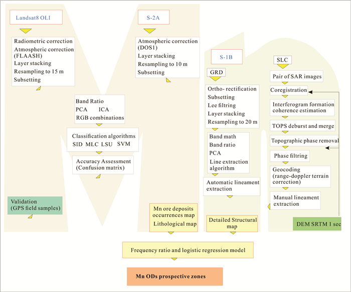
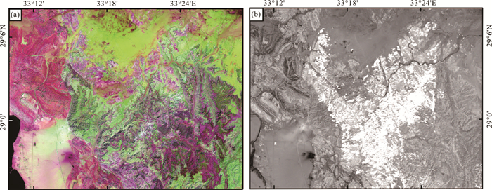
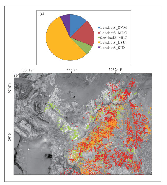
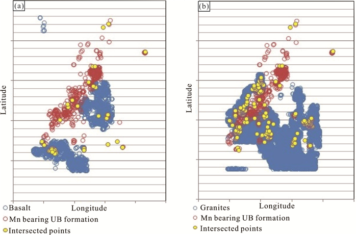
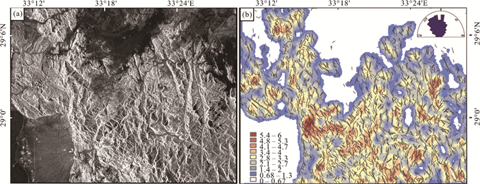
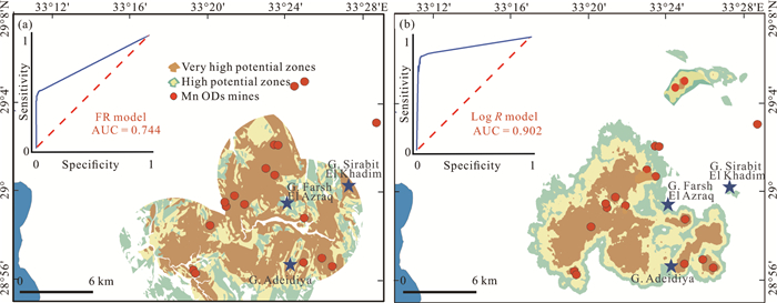
One of the most controversial minerals in their origin and occurrence around the world is manganese deposits. The Abu Zenima area is rated one of the most economically important places where manganese ore deposits (Mn ODs) are located in the southwest Sinai microplate, Egypt. These deposits are confined with the Um Bogma Formation (UBF) and the reserves of this region are relatively small. In this study, optical and radar data are used in a new challenge as an attempt to reach the closest controls and setting of Mn ODs. Moreover, Frequency Ratio (FR) and Logistic Regression (LogR) predictive models are applied to integrate different geospatial thematic maps, to predict new potential resource zones for increasing the ranges of mining quarries. Landsat8 OLI, Sentinel-2A MultiSpectral Instrument and Radar (Sentinel-1B) data are combined for mapping Mn ODs locations and their relationship with geological structures and the surrounding rocks. Band ratio, Principal and Independent Component Analysis techniques and four classification algorithms were implemented to the optical' VNIR and SWIR bands. Unusually, the interferometric processing steps for Sentinel-1 data were made for understanding the tectonic features in the area. The FR and LogR models are validated during fieldwork with known Mn ODs locations. Results indicate that processed images are capable of differentiation of UBF which broadly distributed in the central and southern parts of the area. Mn ODs possibly formed by thermal events that attributed to paleo-volcanic events before the rift stage. The high accuracy of Log

| Abdel-Karim, A., Puskás, Z., Jánosi, M., 2002. Origin and Tectonic History of Some Metamorphic Rocks from Southwest Sinai, Egypt. Acta Mineralogica-Petrographica, 43: 27–38 |
| Abou El Maaty, M. A., Ali-Bik, M. W., Sadek, M. F., 2011. Petrogenesis and Age Dating of Continental Mesozoic Basalts, Um Bogma Area, Sinai, Egypt. Neues Jahrbuch Für Mineralogie-Abhandlungen, 188(2): 199–210. https://doi.org/10.1127/0077-7757/2011/0197 |
| Aboud, E., Qaddah, A., Harbi, H., et al., 2021. Geothermal Resources Database in Saudi Arabia (GRDiSA): GIS Model and Geothermal Favorability Map. Arabian Journal of Geosciences, 14(2): 1–10. https://doi.org/10.1007/s12517-020-06426-z |
| Abouzeid, A. Z. M., Khalid, A. A. M., 2011. Mineral Industry in Egypt-Part I: Metallic Mineral Commodities. Natural Resources, 2(1): 35–53. https://doi.org/10.4236/nr.2011.21006 |
| Ali, B. H., Wilde, S. A., Gabr, M. M. A., 2009. Granitoid Evolution in Sinai, Egypt, Based on Precise SHRIMP U-Pb Zircon Geochronology. Gondwana Research, 15(1): 38–48. https://doi.org/10.1016/j.gr.2008.06.009 |
| AL-Shammari, M. M. A., AL-Shamma'a, A. M., Maliki, A., et al., 2021. Integrated Water Harvesting and Aquifer Recharge Evaluation Methodology Based on Remote Sensing and Geographical Information System: Case Study in Iraq. Natural Resources Research, 30(3): 2119–2143. https://doi.org/10.1007/s11053-021-09835-3 |
| Ayalew, L., Yamagishi, H., 2005. The Application of GIS-Based Logistic Regression for Landslide Susceptibility Mapping in the Kakuda-Yahiko Mountains, Central Japan. Geomorphology, 65(1/2): 15–31. https://doi.org/10.1016/j.geomorph.2004.06.010 |
| Bayer, B., Simoni, A., Mulas, M., et al., 2018. Deformation Responses of Slow Moving Landslides to Seasonal Rainfall in the Northern Apennines, Measured by InSAR. Geomorphology, 308: 293–306. https://doi.org/10.1016/j.geomorph.2018.02.020 |
| Beygi, S., Talovina, I. V., Tadayon, M., et al., 2021. Alteration and Structural Features Mapping in Kacho-Mesqal Zone, Central Iran Using ASTER Remote Sensing Data for Porphyry Copper Exploration. International Journal of Image and Data Fusion, 12(2): 155–175. https://doi.org/10.1080/19479832.2020.1838628 |
| Bishr, A. H., Nas, M. M., Gabr, M. A., 2018. Investigation of the Uranium Source and Its Effect on Contamination of Groundwater in El Rakaiz-El Sahu Area, Southwestern Sinai, Egypt. Nuclear Sciences Scientific Journal, 7(1): 57–71. https://doi.org/10.21608/nssj.2018.30728 |
| Bishta, A. Z., Sonbul, A. R., Kashghari, W., 2014. Utilization of Supervised Classification in Structural and Lithological Mapping of Wadi Al-Marwah Area, NW Arabian Shield, Saudi Arabia. Arabian Journal of Geosciences, 7(9): 3855–3869. https://doi.org/10.1007/s12517-013-1044-9 |
| Bojar, A. V., Fritz, H., Kargl, S., Unzog, W., 2002. Phanerozoic Tectonothermal History of the Arabian-Nubian Shield in the Eastern Desert of Egypt: Evidence from Fission Track and Paleostress Data. Journal of African Earth Sciences, 34(3/4): 191–202. https://doi.org/10.1016/s0899-5362(02)00018-0 |
| Carranza, E. J. M., 2008. Geochemical Anomaly and Mineral Prospectivity Mapping in GIS. In: Handbook of Exploration and Environmental Geochemistry, Vol. 11. Elsevier, Amsterdam |
| Chattoraj, S. L., Prasad, G., Sharma, R. U., et al., 2020. Integration of Remote Sensing, Gravity and Geochemical Data for Exploration of Cu-Mineralization in Alwar Basin, Rajasthan, India. International Journal of Applied Earth Observation and Geoinformation, 91: 102162. https://doi.org/10.1016/j.jag.2020.102162 |
|
Congedo, L., 2013. Semi-Automatic Classification Plugin Documentation. |
| Conoco, C., 1987. Geological Map of Egypt, Scale 1 : 500 000, Bernice Sheet NF 36 NE, The Egyptian General Petroleum Corporation (EGPC), Cairo |
|
Cooley, T., Anderson, G. P., Felde, G. W., et al., 2002. FLAASH, a MODTRAN4-Based Atmospheric Correction Algorithm, Its Application and Validation. IEEE International Geoscience and Remote Sensing Symposium. Toronto, ON, Canada. IEEE, 1414–1418. |
| DiPietro, J. A., 2018. Crystalline-Cored Mid-Continent Anticlines and Domes. Geology and Landscape Evolution, 261–307. https://doi.org/10.1016/b978-0-12-811191-8.00014-2 |
| E1-Gammal, R. M. H., 1984. Geological Studies on the Stratigraphic Succession of Umm Bogma District, West Central Sinai, Egypt: [Dissertation]. Cairo University, Cairo |
| El Agami, N. L., 1996. Geology and Radioactivity Studies on the Paleozoic Rock Units in the Sinai Peninsula, Egypt: [Dissertation]. Mansoura University, Mansoura |
| El-Anwar, E. A. A., 2014. Composition and Origin of the Dolostones of Um Bogma Formation, Lower Carboniferous, West Central Sinai, Egypt. Carbonates Evaporites, 29: 239–250. https://doi.org/10.1007/s13146-014-0188-3 |
| El Khrepy, S., Koulakov, I., Al-Arifi, N., 2016. Crustal and Uppermost Mantle Structure beneath the Continental Rifting Area of the Gulf of Suez from Earthquake Tomography. Tectonophysics, 668/669: 92–104. https://doi.org/10.1016/j.tecto.2015.11.027 |
| El-Rakaib, M. L., El-Aassy, I. E., 1989. Structural Interpretation of Paleozoic–Mesozoic Rocks, Southwestern Sinai, Egypt. Annals Geological Survey, Egypt |
|
Elfadaly, A., Abate, N., Masini, N., et al., 2020. Correction: Elfadaly, A., Abate, N., Masini, N., Lasaponara, R., SAR Sentinel 1 Imaging and Detection of Palaeo-Landscape Features in the Mediterranean Area. Remote Sens. 2020, 12, 2611. Remote Sensing, 12(18): 2878. |
| ESA. Sentinel-1, 2012. ESA's Radar Observatory Mission for GMES Operational Services; ESA SP-1322/1; European Space Agency, Paris |
| Fahim, M. S., El Faramawy, H., Ahmed, A. M., et al., 2013. Characterization of Egyptian Manganese Ores for Production of High Carbon Ferromanganese. Journal of Minerals and Materials Characterization and Engineering, 1(2): 68–74. https://doi.org/10.4236/jmmce.2013.12013 |
| Fathy, K., Zahran, Kh., Radwan, A. H., et al., 2013. Gravity Observations at Sinai Peninsula and Its Geophysical and Geodetic Applications. NRIAG Journal of Astronomy and Geophysics, 2(2): 223–233. https://doi.org/10.1016/j.nrjag.2013.12.003 |
| Feizi, F.; Ramezanali, A. A. K.; Farhadi S., 2021. Application of Multivariate Regression on Magnetic Data to Determine Further Drilling Site for Iron Exploration. Open Geosciences, 13(1): 138–147. https://doi.org/10.1515/geo-2020-0165 |
| Ferretti, A., Monti-Guarnieri, A., Prati, C., et al., 2007. InSAR Principles: Guidelines for SAR Interferometry Processing and Interpretation. ESA Publications TM-19, ESA Publications, Noordwijk |
| Franceschetti, G., Lanari, R., 1999. Synthetic Aperture Radar Processing; Electronic Engineering Systems Series; CRC Press, Boca Raton |
| Gobashy, M. M., Eldougdoug, A., Abdelazeem, M., et al., 2021. Future Development of Gold Mineralization Utilizing Integrated Geology and Aeromagnetic Techniques: A Case Study in the Barramiya Mining District, Central Eastern Desert of Egypt. Natural Resources Research, 30(3): 2007–2028. https://doi.org/10.1007/s11053-021-09824-6 |
| Hosmer, D. W., Lemeshow, S., 2000. Applied Logistic Regression, 2nd Edn. Wiley, New York |
| Hussein, A. A. A., et al., 1982. A Proposed New Classification of the Granites of Egypt. Journal of Volcanology and Geothermal Research, 14(1/2): 187–198. https://doi.org/10.1016/0377-0273(82)90048-8 |
| Ibrahim, A., Ibrahim, S. M. E., Abd El Monsef, M., 2010. Mineralogy, Geochemistry, and Origin of Hydrothermal Manganese Veins at Wadi Maliek, Southern Eastern Desert, Egypt. Arabian Journal of Geosciences, 5: 385–406. https://doi.org/10.1007/s12517-010-0195-1 |
| Issawi, B., Jux, U., 1982. Contribution of the Stratigraphy of the Paleozoic Rocks in Egypt. Annals Geological Survey, Egypt, 12: 1–24 |
| Javhar, A., Chen, X., Bao, A. M., et al., 2019. Comparison of Multi-Resolution Optical Landsat-8, Sentinel-2 and Radar Sentinel-1 Data for Automatic Lineament Extraction: A Case Study of Alichur Area, SE Pamir. Remote Sensing, 11(7): 778. https://doi.org/10.3390/rs11070778 |
| Jensen, J. R., 1996. Introductory Image Processing: A Remote Sensing Perspective; Prentice Hall, New York |
| Khalifa, I. H., Seif, R. A., 2014. Geochemistry of Manganese-Iron Ores at Um Bogma Area, West Central Sinai, Egypt. International Journal of Advanced Scientific and Technical Research, 6: 258–283 |
| Kora, M., 1984. The Paleozoic Outcrops of Um Bogma Area: [Dissertation]. Mansoura University, Mansoura |
| Kora, M., El Shahat, A., Abu Shabana, M., 1994. Lithostratigraphy of the Manganese Bearing Um Bogma Formation, West Central Sinai, Egypt. Journal of African Earth Sciences, 18(2): 151–162. https://doi.org/10.1016/0899-5362(94)90027-2 |
| Korup, O., Stolle, A., 2014. Landslide Prediction from Machine Learning. Geology Today, 30(1): 26–33. https://doi.org/10.1111/gto.12034 |
| Kostandi, A. B., 1959. Facies Maps for the Study of the Paleozoic and Mesozoic Sedimentary Basins of the Egyptian Region. First Arab Petroleum Congress, 2: 54–62 |
| Kumar, C., Chatterjee, S., Oommen, T., et al., 2020. Automated Lithological Mapping by Integrating Spectral Enhancement Techniques and Machine Learning Algorithms Using AVIRIS-NG Hyperspectral Data in Gold-Bearing Granite-Greenstone Rocks in Hutti, India. International Journal of Applied Earth Observation and Geoinformation, 86: 102006. https://doi.org/10.1016/j.jag.2019.102006 |
| Lee, C., Oh, H. J., Cho, S. J., et al., 2019. Three-Dimensional Prospectivity Mapping of Skarn-Type Mineralization in the Southern Taebaek Area, Korea. Geosciences Journal, 23(2): 327–339. https://doi.org/10.1007/s12303-018-0035-y |
|
Lee, S., Oh, H. J., Park, N. W., 2006. Mineral Potential Assessment of Sedimentary Deposit Using Frequency Ratio and Logistic Regression of Gangreung Area, Korea. 2006 IEEE International Symposium on Geoscience and Remote Sensing. Denver, CO, USA. IEEE, 1576–1579. |
| Magaritz, M., Brenner, I. B., 1979. The Geochemistry of a Lenticular Manganese-Ore Deposit (Um Bogma, Southern Sinai). Mineralium Deposita, 14(1): 1–13. https://doi.org/10.1007/bf00201863 |
| Marghany, M., Hashim, M., 2010. Lineament Mapping Using Multispectral Remote Sensing Satellite Data. Research Journal of Applied Sciences, 5(2): 126–130. https://doi.org/10.3923/rjasci.2010.126.130 |
| Mart, J., Sass, E., 1972. Geology and Origin of the Manganese Ore of Um Bogma, Sinai. Economic Geology, 67(2): 145–155. https://doi.org/10.2113/gsecongeo.67.2.145 |
|
Maynard, J. B., 2017. The Origin and Formation of Manganese Rocks and Ores. In: Barry Maynard, J., ed., Isotope Geochemistry. Elsevier, Amsterdam. |
| McClusky, S., Reilinger, R., Mahmoud, S., et al., 2003. GPS Constraints on Africa (Nubia) and Arabia Plate Motions. Geophysical Journal International, 155(1): 126–138. https://doi.org/10.1046/j.1365-246x.2003.02023.x |
| Mondini, A., Santangelo, M., Rocchetti, M., et al., 2019. Sentinel-1 SAR Amplitude Imagery for Rapid Landslide Detection. Remote Sensing, 11(7): 760. https://doi.org/10.3390/rs11070760 |
| Moustafa, A. R., 2004. Geologic Maps of the Eastern Side of the Suez Rift (Western Sinai Peninsula), Egypt. AAPG/Datapages, Inc. GIS Series (Geologic Maps and cross Sections in Digital Format on CD) |
| Oh, H. J., Lee, S., 2008. Regional Probabilistic and Statistical Mineral Potential Mapping of Gold-Silver Deposits Using GIS in the Gangreung Area, Korea. Resource Geology, 58(2): 171–187. https://doi.org/10.1111/j.1751-3928.2008.00050.x |
| Oh, H. J., Lee, S., 2010. Application of Artificial Neural Network for Gold-Silver Deposits Potential Mapping: A Case Study of Korea. Natural Resources Research, 19(2): 103–124. https://doi.org/10.1007/s11053-010-9112-2 |
| Parsa, M., 2021. A Data Augmentation Approach to XGboost-Based Mineral Potential Mapping: An Example of Carbonate-Hosted ZNPB Mineral Systems of Western Iran. Journal of Geochemical Exploration, 228: 106811. https://doi.org/10.1016/j.gexplo.2021.106811 |
| Parsa, M., Pour, A. B., 2021. A Simulation-Based Framework for Modulating the Effects of Subjectivity in Greenfield Mineral Prospectivity Mapping with Geochemical and Geological Data. Journal of Geochemical Exploration, 229: 106838. https://doi.org/10.1016/j.gexplo.2021.106838 |
| Pour, A. B., Park, Y., Park, T. Y. S., et al., 2018. Regional Geology Mapping Using Satellite-Based Remote Sensing Approach in Northern Victoria Land, Antarctica. Polar Science, 16: 23–46. https://doi.org/10.1016/j.polar.2018.02.004 |
| Rabeh, T., 2016. Tracing the Manganese Ore Accumulations in Sinai Peninsula, Egypt, Using Magnetic Method. Environmental Earth Sciences, 75(3): 1–12. https://doi.org/10.1007/s12665-015-4966-6 |
| Rabeh, T., 2010. Evaluation the Tectonics of Sinai Peninsula, Egypt. Tectonics, 93–100 |
| Ragab, A. I., El-Kalioub, B. A., 1992. Geodynamic of the Gulf of Suez-Red Sea Rifting and Origin of within Plate Magmatism. Journal of African Earth Sciences (and the Middle East), 14(3): 351–360. https://doi.org/10.1016/0899-5362(92)90038-e |
| Rahman, M. A., Rusteberg, B., Uddin, M. S., et al., 2013. An Integrated Study of Spatial Multicriteria Analysis and Mathematical Modelling for Managed Aquifer Recharge Site Suitability Mapping and Site Ranking at Northern Gaza Coastal Aquifer. Journal of Environmental Management, 124: 25–39. https://doi.org/10.1016/j.jenvman.2013.03.023 |
| Rajendran, S., Nasir, S., 2013. Mapping of Manganese Potential Areas Using ASTER Satellite Data in Parts of Sultanate of Oman. International Journal of Geosciences and Geomatics, 1/2: 92–101 |
| Saad, N. A., Zidan, B. I., Khalil, K. I., 1994. Geochemistry and Origin of the Manganese Deposits in the Umm Bogma Region, West Central Sinai, Egypt. Journal of African Earth Sciences, 19(1/2): 109–116. https://doi.org/10.1016/0899-5362(94)90043-4 |
| Said, R., 1962. The Geology of Egypt. Elsevier, Amsterdam, 377 |
| Simmonds, V., Ghasemi, F., 2007. Investigation of Manganese Mineralization in Idahlu and Jokandy, Southwest of Hashtrood, NW Iran. BHM Berg-Und Hüttenmännische Monatshefte, 152(8): 263–267. https://doi.org/10.1007/s00501-007-0308-7 |
| Solaimani, K., Mousavi, S. Z., Kavian, A., 2013. Landslide Susceptibility Mapping Based on Frequency Ratio and Logistic Regression Models. Arabian Journal of Geosciences, 6(7): 2557–2569. https://doi.org/10.1007/s12517-012-0526-5 |
| Tende, A. W., Aminu, M. D., Gajere, J. N., 2021. A Spatial Analysis for Geothermal Energy Exploration Using Bivariate Predictive Modelling. Scientific Reports, 11: 19755. https://doi.org/10.1038/s41598-021-99244-6 |
| Thomas, A., 2021. Mapping of Surface Deformation Associated with the 5.2 Magnitude Stilfontein Earthquake of 3 April 2017 Using Radar Interferometry. The Egyptian Journal of Remote Sensing and Space Science, 24(1): 85–108. https://doi.org/10.1016/j.ejrs.2020.01.005 |
| Torsvik, T. H., Cocks, L. R. M., 2012. The Palaeozoic Palaeogeography of Central Gondwana. Geological Society, London, Special Publications, 357(1): 137–166. https://doi.org/10.1144/sp357.8 |
| Traore, M., Wambo, J. D. T., Ndepete, C. P., et al., 2020. Lithological and Alteration Mineral Mapping for Alluvial Gold Exploration in the South East of Birao Area, Central African Republic Using Landsat-8 Operational Land Imager (OLI) Data. Journal of African Earth Sciences, 170: 103933. https://doi.org/10.1016/j.jafrearsci.2020.103933 |
| Tzouvaras, M., Danezis, C., Hadjimitsis, D. G., 2020. Small Scale Landslide Detection Using Sentinel-1 Interferometric SAR Coherence. Remote Sensing, 12(10): 1560. https://doi.org/10.3390/rs12101560 |
| Xu, R. D., Liu, J., Xu, J. H., 2018. Extraction of High-Precision Urban Impervious Surfaces from Sentinel-2 Multispectral Imagery via Modified Linear Spectral Mixture Analysis. Sensors (Basel, Switzerland), 18(9): 2873. https://doi.org/10.3390/s18092873 |
| Zaky, K. S., 2017. Paleostress Analysis of the Brittle Deformations on the Northwestern Margin of the Red Sea and the Southern Gulf of Suez, Egypt. Geotectonics, 51(6): 625–652. https://doi.org/10.1134/s0016852117060097 |
| Zhang, H. K., Roy, D. P., Yan, L., et al., 2018. Characterization of Sentinel-2A and Landsat-8 Top of Atmosphere, Surface, and Nadir BRDF Adjusted Reflectance and NDVI Differences. Remote Sensing of Environment, 215: 482–494. https://doi.org/10.1016/j.rse.2018.04.031 |
| Zoheir, B., Emam, A., Abdel-Wahed, M., et al., 2019. Multispectral and Radar Data for the Setting of Gold Mineralization in the South Eastern Desert, Egypt. Remote Sensing, 11(12): 1450. https://10.3390/rs1112145040 doi: 10.3390/rs1112145040 |
Figures(15) / Tables(7)
Copyright © 2013-2020 Journal of Earth Science 鄂ICP备15021562号-2
Tel: +86-27-67885075 Fax: +86-27-67885075 E-mail: xbb@cug.edu.cn
Address: Editorial Office of Journal, China University of Geosciences, Yujiashan, Wuhan, Hubei 430074, P. R. China
Supported by:
Beijing Renhe Information Technology Co. Ltd
E-mail:
info@rhhz.net


 DownLoad: