| Citation: | Zhongmin Mao, Yuyong Jiao, Fei Tan, Qi Xin, Zeng Cong. Susceptibility Mapping of Ground Collapse Caused by Anthropogenic Activities. Journal of Earth Science, 2025, 36(3): 1168-1180. doi: 10.1007/s12583-022-1644-y

|
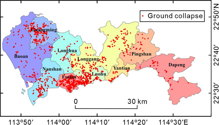
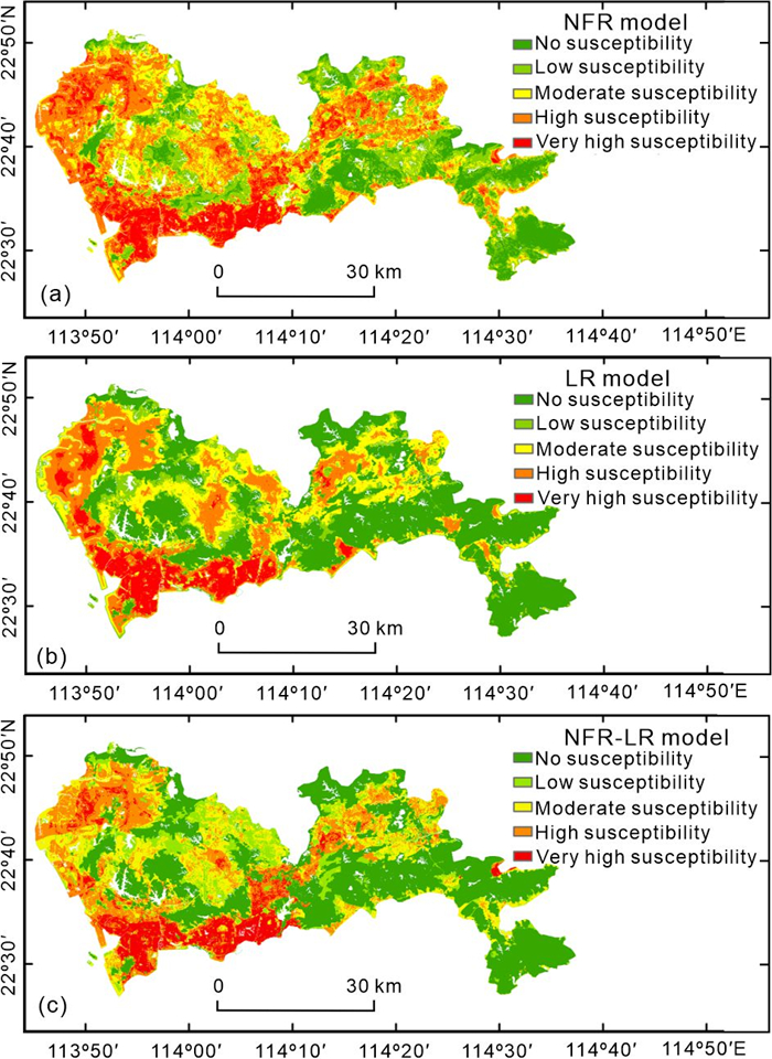
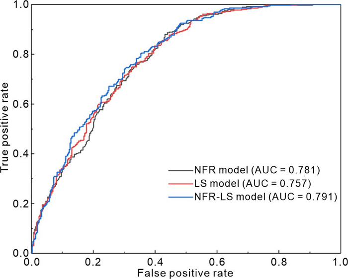
With the rapid urbanization process, ground collapses caused by anthropogenic activities occur frequently. Accurate susceptibility mapping is of great significance for disaster prevention and control. In this study, 1 198 ground collapse cases in Shenzhen from 2017 to 2020 were collected. Eight effective factors (elevation, relief, clay proportion, average annual precipitation, distance from water, land use type, building density, and road density) were selected to construct the evaluation index system. Ground collapse susceptibility was analyzed and mapped using the normalized frequency ratio (NFR), logistic regression (LR), and NFR-LR coupling models. Finally, the result rationality and performance of the three models were compared through frequency ratio (FR) and ROC curve. The results indicate that all three models can effectively evaluate the ground collapse susceptibility (AUC > 0.7), and the NFR-LR model result is more rational and has the best performance (AUC = 0.791). The very high and high susceptibility zones cover a total area of 545.68 km2 and involve Nanshan, Luohu, and Futian District, as well as some areas of Baoan, Guangming, and Longgang District. The ground collapses in Shenzhen mainly occurred in the built-up areas, and the greater intensity of anthropogenic activities, the more susceptible to the disaster.

| Akgun, A., Dag, S., Bulut, F., 2008. Landslide Susceptibility Mapping for a Landslide-Prone Area (Findikli, NE of Turkey) by Likelihood-Frequency Ratio and Weighted Linear Combination Models. Environmental Geology, 54(6): 1127–1143. https://doi.org/10.1007/s00254-007-0882-8 |
|
Banks, V. J., Reeves, H. J., Ward, E. K., et al., 2015. Media, Sinkholes and the UK National Karst Database. In: 14th Sinkhole Conference. 223–229. |
| Bradley, A. P., 1997. The Use of the Area under the ROC Curve in the Evaluation of Machine Learning Algorithms. Pattern Recognition, 30(7): 1145–1159. https://doi.org/10.1016/s0031-3203(96)00142-2 |
| Bragagnolo, L., da Silva, R. V., Grzybowski, J. M. V., 2020. Artificial Neural Network Ensembles Applied to the Mapping of Landslide Susceptibility. CATENA, 184: 104240. https://doi.org/10.1016/j.catena.2019.104240 |
| Brandolini, P., Cappadonia, C., Luberti, G. M., et al., 2020. Geomorphology of the Anthropocene in Mediterranean Urban Areas. Progress in Physical Geography: Earth and Environment, 44(4): 461–494. https://doi.org/10.1177/0309133319881108 |
| Brown, A. G., Tooth, S., Bullard, J. E., et al., 2017. The Geomorphology of the Anthropocene: Emergence, Status and Implications. Earth Surface Processes and Landforms, 42(1): 71–90. https://doi.org/10.1002/esp.3943 |
| Budimir, M. E. A., Atkinson, P. M., Lewis, H. G., 2015. A Systematic Review of Landslide Probability Mapping Using Logistic Regression. Landslides, 12(3): 419–436. https://doi.org/10.1007/s10346-014-0550-5 |
| Butchibabu, B., Khan, P. K., Jha, P. C., 2019. Foundation Evaluation of Underground Metro Rail Station Using Geophysical and Geotechnical Investigations. Engineering Geology, 248: 140–154. https://doi.org/10.1016/j.enggeo.2018.12.001 |
| Choi, J., Oh, H. J., Lee, H. J., et al., 2012. Combining Landslide Susceptibility Maps Obtained from Frequency Ratio, Logistic Regression, and Artificial Neural Network Models Using ASTER Images and GIS. Engineering Geology, 124: 12–23. https://doi.org/10.1016/j.enggeo.2011.09.011 |
| Coombs, A., 2014. Defining the Anthropocene. Frontiers in Ecology and the Environment, 12(4): 208 |
| Costache, R., 2019. Flash-Flood Potential Assessment in the Upper and Middle Sector of Prahova River Catchment (Romania): A Comparative Approach between Four Hybrid Models. Science of the Total Environment, 659: 1115–1134. https://doi.org/10.1016/j.scitotenv.2018.12.397 |
| Crutzen, P. J., 2002. The Effects of Industrial and Agricultural Practices on Atmospheric Chemistry and Climate during the Anthropocene. Journal of Environmental Science and Health, Part A, 37(4): 423–424. https://doi.org/10.1081/ese-120003224 |
| Dai, F. C., Lee, C. F., Ngai, Y. Y., 2002. Landslide Risk Assessment and Management: An Overview. Engineering Geology, 64(1): 65–87. https://doi.org/10.1016/s0013-7952(01)00093-x |
| de Queiroz Salles, L., Galvão, P., Leal, L. R. B., et al., 2018. Evaluation of Susceptibility for Terrain Collapse and Subsidence in Karst Areas, Municipality of Iraquara, Chapada Diamantina (BA), Brazil. Environmental Earth Sciences, 77(16): 593. https://doi.org/10.1007/s12665-018-7769-8 |
| Deng, A. S., Ju, J. H., 1994. Land Subsidence, Sinkhole Collapse and Earth Fissure Occurrence and Control in China. Hydrological Sciences Journal, 39(3): 245–256. https://doi.org/10.1080/02626669409492741 |
| Dixon, S. J., Viles, H. A., Garrett, B. L., 2018. Ozymandias in the Anthropocene: The City as an Emerging Landform. Area, 50(1): 117–125. https://doi.org/10.1111/area.12358 |
| Erener, A., Mutlu, A., Düzgün, H. S., 2016. A Comparative Study for Landslide Susceptibility Mapping Using GIS-Based Multi-Criteria Decision Analysis (MCDA), Logistic Regression (LR) and Association Rule Mining (ARM). Engineering Geology, 203: 45–55. https://doi.org/10.1016/j.enggeo.2015.09.007 |
| Feizizadeh, B., Blaschke, T., 2013. GIS-Multicriteria Decision Analysis for Landslide Susceptibility Mapping: Comparing Three Methods for the Urmia Lake Basin, Iran. Natural Hazards, 65(3): 2105–2128. https://doi.org/10.1007/s11069-012-0463-3 |
|
Galloway, D. L., Jones, D. R., Ingebritsen, S. E., 1999. Land Subsidence in the United States. U. S. Geological Survey Circular. USGS Circ. 1182. |
| Gill, J. C., Malamud, B. D., 2017. Anthropogenic Processes, Natural Hazards, and Interactions in a Multi-Hazard Framework. Earth-Science Reviews, 166: 246–269. https://doi.org/10.1016/j.earscirev.2017.01.002 |
| Guarino, P. M., Nisio, S., 2012. Anthropogenic Sinkholes in the Territory of the City of Naples (Southern Italy). Physics and Chemistry of the Earth, Parts A/B/C, 49: 92–102. https://doi.org/10.1016/j.pce.2011.10.023 |
| Guo, C. B., Montgomery, D. R., Zhang, Y. S., et al., 2015. Quantitative Assessment of Landslide Susceptibility along the Xianshuihe Fault Zone, Tibetan Plateau, China. Geomorphology, 248: 93–110. https://doi.org/10.1016/j.geomorph.2015.07.012 |
| Guo, Z. Z., Yin, K. L., Huang, F. M., et al., 2019. Evaluation of Landslide Susceptibility Based on Landslide Classification and Weighted Frequency Ratio Model. Chinese Journal of Rock Mechanics and Engineering, 38(2): 287–300. https://doi.org/10.13722/j.cnki.jrme.2018.0838 (in Chinese with English Abstract) |
| Hanley, J. A., McNeil, B. J., 1982. The Meaning and Use of the Area under a Receiver Operating Characteristic (ROC) Curve. Radiology, 143(1): 29–36. https://doi.org/10.1148/radiology.143.1.7063747 |
| Hermosilla, R. G., 2012. The Guatemala City Sinkhole Collapses. Carbonates and Evaporites, 27(2): 103–107. https://doi.org/10.1007/s13146-011-0074-1 |
| Hosmer, D. W. Jr., Lemeshow, S., 2001. Applied Logistic Regression. John Wiley & Sons Inc |
| Hou, Y. J., Fang, Q., Zhang, D. L., et al., 2015. Excavation Failure Due to Pipeline Damage during Shallow Tunnelling in Soft Ground. Tunnelling and Underground Space Technology, 46: 76–84. https://doi.org/10.1016/j.tust.2014.11.004 |
| Huang, D., Liu, X. H., Jiang, S. Z., et al., 2018. Current State and Future Perspectives of Sewer Networks in Urban China. Frontiers of Environmental Science & Engineering, 12(3): 2. https://doi.org/10.1007/s11783-018-1023-1 |
| Huang, F. M., Wang, Y., Dong, Z. L., et al., 2019. Regional Landslide Susceptibility Mapping Based on Grey Relational Degree Model. Earth Science, 44(2): 664–676. https://doi.org/10.3799/dqkx.2018.175 (in Chinese with English Abstract) |
| Huang, F. M., Ye, Z., Yao, C., et al., 2020. Uncertainties of Landslide Susceptibility Prediction: Different Attribute Interval Divisions of Environmental Factors and Different Data-Based Models. Earth Science, 45(12): 4535–4549. https://doi.org/10.3799/dqkx.2020.247 (in Chinese with English Abstract) |
| Huang, F. M., Chen, J. W., Fan, X. M., et al., 2022. Logistic Regression Fitting of Rainfall-Induced Landslide Occurrence Probability and Continuous Landslide Hazard Prediction Modelling. Earth Science, 47(12): 4609–4628. https://doi.org/10.3799/dqkx.2021.164 (in Chinese with English Abstract) |
| Huang, Y., Zhao, L., 2018. Review on Landslide Susceptibility Mapping Using Support Vector Machines. CATENA, 165: 520–529. https://doi.org/10.1016/j.catena.2018.03.003 |
| Intarawichian, N., Dasananda, S., 2011. Frequency Ratio Model Based Landslide Susceptibility Mapping in Lower Mae Chaem Watershed, Northern Thailand. Environmental Earth Sciences, 64(8): 2271–2285. https://doi.org/10.1007/s12665-011-1055-3 |
| Jeong, S. W., Yum, B. W., Ryu, D. W., et al., 2019. The Influence of Clay Content on Cave-Ins in Tank Model Tests and Monitoring Indicators of Sinkhole Formation. Applied Sciences, 9(11): 2346. https://doi.org/10.3390/app9112346 |
| Jia, X. B., 2016a. Analyzing the Distribution Characteristics of the Ground Collapse Hazard in Shenzhen. Journal of Catastrophology, 31(4): 116–121. https://doi.org/10.3969/j.issn.1000-811x.2016.04.020 (in Chinese with English Abstract) |
| Jia, X. B., 2016b. Analyzing the Reason of Ground Collapse Disaster in Shenzhen. Journal of Catastrophology, 31(3): 114–118. https://doi.org/10.3969/j.issn.1000-811x.2016.03.019 (in Chinese with English Abstract) |
| Jiang, F. W., 2020. Criteria of Sinkhole Formation in Soils from Physical Models. Bulletin of Engineering Geology and the Environment, 79(7): 3833–3841. https://doi.org/10.1007/s10064-020-01768-0 |
| Jiao, Y. Y., Ye, W. T., Shen, L. Y., et al., 2023. How Does the New Generation of Information Technology Support the Urban Transparent Geology? Journal of Earth Science, 34(4): 1312. https://doi.org/10.1007/s12583-023-1885-4 |
| Jo, Y. S., Cho, S. H., Jang, Y. S., 2016. Field Investigation and Analysis of Ground Sinking Development in a Metropolitan City, Seoul, Korea. Environmental Earth Sciences, 75(20): 1353. https://doi.org/10.1007/s12665-016-6141-0 |
| Kang, I. S., 2014. Sinkhole are here to Stay. Korea Joong-Ang Daily, 2014-8-27 |
| Kayastha, P., 2015. Landslide Susceptibility Mapping and Factor Effect Analysis Using Frequency Ratio in a Catchment Scale: A Case Study from Garuwa Sub-Basin, East Nepal. Arabian Journal of Geosciences, 8(10): 8601–8613. https://doi.org/10.1007/s12517-015-1831-6 |
| Keys, P. W., Galaz, V., Dyer, M., et al., 2019. Anthropocene Risk. Nature Sustainability, 2(8): 667–673. https://doi.org/10.1038/s41893-019-0327-x |
| Komac, M., 2006. A Landslide Susceptibility Model Using the Analytical Hierarchy Process Method and Multivariate Statistics in Perialpine Slovenia. Geomorphology, 74(1/2/3/4): 17–28. https://doi.org/10.1016/j.geomorph.2005.07.005 |
| Kong, S., Kim, D., Lee, D., et al., 2018. Field and Laboratory Assessment of Ground Subsidence Induced by Underground Cavity under the Sewer Pipe. Geomechanics and Engineering, 16(3): 285–293. https://doi.org/10.12989/gae.2018.16.3.285 |
| Lan, H. X., Zhou, C. H., Wang, L. J., et al., 2004. Landslide Hazard Spatial Analysis and Prediction Using GIS in the Xiaojiang Watershed, Yunnan, China. Engineering Geology, 76(1/2): 109–128. https://doi.org/10.1016/j.enggeo.2004.06.009 |
| Lee, M. J., Choi, J. W., Oh, H. J., et al., 2012. Ensemble-Based Landslide Susceptibility Maps in Jinbu Area, Korea. Environmental Earth Sciences, 67(1): 23–37. https://doi.org/10.1007/s12665-011-1477-y |
| Lee, S., Pradhan, B., 2007. Landslide Hazard Mapping at Selangor, Malaysia Using Frequency Ratio and Logistic Regression Models. Landslides, 4(1): 33–41. https://doi.org/10.1007/s10346-006-0047-y |
| Li, Q., Yu, Y., Jiang, X. Q., et al., 2019. Multifactor-Based Environmental Risk Assessment for Sustainable Land-Use Planning in Shenzhen, China. Science of the Total Environment, 657: 1051–1063. https://doi.org/10.1016/j.scitotenv.2018.12.118 |
| Li, X. N., Yan, D. H., Wang, K., et al., 2019. Flood Risk Assessment of Global Watersheds Based on Multiple Machine Learning Models. Water, 11(8): 1654. https://doi.org/10.3390/w11081654 |
| Li, Y. W., Xu, L. R., Shang, Y. H., et al., 2024. Debris Flow Susceptibility Evaluation in Meizoseismal Region: A Case Study in Jiuzhaigou, China. Journal of Earth Science, 35(1): 263–279. https://doi.org/10.1007/s12583-022-1803-1 |
|
Liu, M. X., Chen, X., Yang, S. N., 2014. Collapse Landslide and Mudslides Hazard Zonation. Landslide Science for a Safer Geoenvironment. Springer, Cham, 457–462. |
| Liu, Y. F., Fang, J. L., Chen, X. H., et al., 2014. Evaluation of Landslide Susceptibility in Zigui County Based on Certainty Factor Method. Journal of Natural Disasters, 23(6): 209–217. https://doi.org/10.13577/j.jnd.2014.0626 (in Chinese with English Abstract) |
| Lizardi-Jiménez, M. A., Leal-Bautista, R. M., Ordaz, A., et al., 2015. Airlift Bioreactors for Hydrocarbon Water Pollution Remediation in a Tourism Development Pole. Desalination and Water Treatment, 54(1): 44–49. https://doi.org/10.1080/19443994.2013.876670 |
| Luo, H. B., Huang, G., Wu, X. M., et al., 2009. Ecological Engineering Analysis and Eco-Hydrodynamic Simulation of Tidal Rivers in Shenzhen City of China. Ecological Engineering, 35(8): 1129–1137. https://doi.org/10.1016/j.ecoleng.2008.12.015 |
| Marjanović, M., Kovačević, M., Bajat, B., et al., 2011. Landslide Susceptibility Assessment Using SVM Machine Learning Algorithm. Engineering Geology, 123(3): 225–234. https://doi.org/10.1016/j.enggeo.2011.09.006 |
| Ma, S. Y., Shao, X. Y., Xu, C., 2023. Landslide Susceptibility Mapping in Terms of the Slope-Unit or Raster-Unit, which is Better? Journal of Earth Science, 34(2): 386–397. https://doi.org/10.1007/s12583-021-1407-1 |
| Oh, H. J., Lee, S., 2010. Assessment of Ground Subsidence Using GIS and the Weights-of-Evidence Model. Engineering Geology, 115(1/2): 36–48. https://doi.org/10.1016/j.enggeo.2010.06.015 |
| Pandey, A. K., Gogoi, J., Pandey, P., 2019. Mapping Shallow Subsurface to Identify Sinkhole Formation in Urban Areas Using Ground Penetration Radar: A Case Study from Hyderabad, India. Current Science, 117(10): 1710–1715. https://doi.org/10.18520/cs/v117/i10/1710-1715 |
| Papadopoulou-Vrynioti, K., Bathrellos, G. D., Skilodimou, H. D., et al., 2013. Karst Collapse Susceptibility Mapping Considering Peak Ground Acceleration in a Rapidly Growing Urban Area. Engineering Geology, 158: 77–88. https://doi.org/10.1016/j.enggeo.2013.02.009 |
|
Parise, M., 2022. Sinkholes, Subsidence and Related Mass Movements. In: Shroder, J. F., ed., Treatise on Geomorphology (Second Edition). Academic Press. 5: 200–220. |
| Pellicani, R., Spilotro, G., Gutiérrez, F., 2017. Susceptibility Mapping of Instability Related to Shallow Mining Cavities in a Built-up Environment. Engineering Geology, 217: 81–88. https://doi.org/10.1016/j.enggeo.2016.12.011 |
| Perez, A. L., Nam, B. H., Alrowaimi, M., et al., 2017. Experimental Study on Sinkholes: Soil-Groundwater Behaviors under Varied Hydrogeological Conditions. Journal of Testing and Evaluation, 45(1): 208–219. https://doi.org/10.1520/jte20160166 |
| Perrin, J., Cartannaz, C., Noury, G., et al., 2015. A Multicriteria Approach to Karst Subsidence Hazard Mapping Supported by Weights-of-Evidence Analysis. Engineering Geology, 197: 296–305. https://doi.org/10.1016/j.enggeo.2015.09.001 |
|
Pradhan, B., Seeni, M. I., Kalantar, B., 2017. Performance Evaluation and Sensitivity Analysis of Expert-Based, Statistical, Machine Learning, and Hybrid Models for Producing Landslide Susceptibility Maps. Laser Scanning Applications in Landslide Assessment. Springer International Publishing, Cham. 193–232. |
| Price, S. J., Ford, J. R., Cooper, A. H., et al., 2011. Humans as Major Geological and Geomorphological Agents in the Anthropocene: The Significance of Artificial Ground in Great Britain. Philosophical Transactions Series A, Mathematical, Physical, and Engineering Sciences, 369(1938): 1056–1084. https://doi.org/10.1098/rsta.2010.0296 |
| Quan, H. C., Lee, B. G., 2012. GIS-Based Landslide Susceptibility Mapping Using Analytic Hierarchy Process and Artificial Neural Network in Jeju (Korea). KSCE Journal of Civil Engineering, 16(7): 1258–1266. https://doi.org/10.1007/s12205-012-1242-0 |
| Sato, K., Akiba, S., Kanou, Y., et al., 2015. Estimation Method of Cavity below the Road Surface Considering Soundness of Pavement for the Heavy Traffic Road. Journal of Japan Society of Civil Engineers, Ser E1 (Pavement Engineering), 71(3): 135–143. https://doi.org/10.2208/jscejpe.71.i_135 |
| Scotto di Santolo, A., Forte, G., Santo, A., 2018. Analysis of Sinkhole Triggering Mechanisms in the Hinterland of Naples (Southern Italy). Engineering Geology, 237: 42–52. https://doi.org/10.1016/j.enggeo.2018.02.014 |
|
Shenzhen Statistics Bureau, 2020. Shenzhen Statistical Yearbook. (2020-12-31). |
| Shi, X. Y., Wang, Y., Jiao, J. J., et al., 2018. Assessing Major Factors Affecting Shallow Groundwater Geochemical Evolution in a Highly Urbanized Coastal Area of Shenzhen City, China. Journal of Geochemical Exploration, 184: 17–27. https://doi.org/10.1016/j.gexplo.2017.10.003 |
| Subramanian, M., 2019. Anthropocene Now: Influential Panel Votes to Recognize Earth's New Epoch. Nature. https://doi.org/10.1038/d41586-019-01641-5 |
| Tan, Y., Long, Y. Y., 2021. Review of Cave-in Failures of Urban Roadways in China: A Database. Journal of Performance of Constructed Facilities, 35(6): 04021080. https://doi.org/10.1061/(asce)cf.1943-5509.0001658 |
| Tang, X. W., Gan, P. L., Liu, W., et al., 2017. Surface Settlements Induced by Tunneling in Permeable Strata: A Case History of Shenzhen Metro. Journal of Zhejiang University: Science A, 18(10): 757–775. https://doi.org/10.1631/jzus.A1600522 |
| Tang, Y., Chan, D. H., Zhu, D. Z., 2017. A Coupled Discrete Element Model for the Simulation of Soil and Water Flow through an Orifice. International Journal for Numerical and Analytical Methods in Geomechanics, 41(14): 1477–1493. https://doi.org/10.1002/nag.2677 |
| Tarolli, P., Sofia, G., 2016. Human Topographic Signatures and Derived Geomorphic Processes across Landscapes. Geomorphology, 255: 140–161. https://doi.org/10.1016/j.geomorph.2015.12.007 |
| Tooth, S., Rodnight, H., McCarthy, T. S., et al., 2009. Late Quaternary Dynamics of a South African Floodplain Wetland and the Implications for Assessing Recent Human Impacts. Geomorphology, 106(3/4): 278–291. https://doi.org/10.1016/j.geomorph.2008.11.009 |
| United Nations, 2015. World Urbanization Prospects: The 2014 Revision. Highlights Department of Economic and Social Affairs, Population Division, New York |
| Vakhshoori, V., Zare, M., 2016. Landslide Susceptibility Mapping by Comparing Weight of Evidence, Fuzzy Logic, and Frequency Ratio Methods. Geomatics, Natural Hazards and Risk, 7(5): 1731–1752. https://doi.org/10.1080/19475705.2016.1144655 |
| Wang, Y., Cao, Y., Xu, F. D., et al., 2024. Reservoir Landslide Susceptibility Prediction Considering Non-Landslide Sampling and Ensemble Machine Learning Methods. Earth Science, 49(5): 1619–1635. https://doi.org/10.3799/dqkx.2022.407 (in Chinese with English Abstract) |
| Xia, P., Hu, X. L., Wu, S. S., et al., 2020. Slope Stability Analysis Based on Group Decision Theory and Fuzzy Comprehensive Evaluation. Journal of Earth Science, 31(6): 1121–1132. https://doi.org/10.1007/s12583-020-1101-8 |
| Xu, C., Xu, X. W., Dai, F. C., et al., 2012. Landslide Hazard Mapping Using GIS and Weight of Evidence Model in Qingshui River Watershed of 2008 Wenchuan Earthquake Struck Region. Journal of Earth Science, 23(1): 97–120. https://doi.org/10.1007/s12583-012-0236-7 |
| Xu, L. H., Xu, H. F., Wang, T. Y., et al., 2019. Measuring Urban Spatial Activity Structures: A Comparative Analysis. Sustainability, 11(24): 7085. https://doi.org/10.3390/su11247085 |
| Xu, X., 2017. Kilometer Grid Data Set of China's Population Spatial Distribution. Data Registration and Publishing System, China Resource and Environment Science and Data Center, Beijing (in Chinese) |
| Yan, F., Zhang, Q. W., Ye, S., et al., 2019. A Novel Hybrid Approach for Landslide Susceptibility Mapping Integrating Analytical Hierarchy Process and Normalized Frequency Ratio Methods with the Cloud Model. Geomorphology, 327: 170–187. https://doi.org/10.1016/j.geomorph.2018.10.024 |
| Yeon, Y. K., Han, J. G., Ryu, K. H., 2010. Landslide Susceptibility Mapping in Injae, Korea, Using a Decision Tree. Engineering Geology, 116(3/4): 274–283. https://doi.org/10.1016/j.enggeo.2010.09.009 |
| Zhao, Y., Wang, R., Jiang, Y. J., et al., 2019. GIS-Based Logistic Regression for Rainfall-Induced Landslide Susceptibility Mapping under Different Grid Sizes in Yueqing, Southeastern China. Engineering Geology, 259: 105147. https://doi.org/10.1016/j.enggeo.2019.105147 |
| Zhou, S. H., Chen, G. Q., Fang, L. G., et al., 2016. GIS-Based Integration of Subjective and Objective Weighting Methods for Regional Landslides Susceptibility Mapping. Sustainability, 8(4): 334. https://doi.org/10.3390/su8040334 |
Figures(5) / Tables(5)
Copyright © 2013-2020 Journal of Earth Science 鄂ICP备15021562号-2
Tel: +86-27-67885075 Fax: +86-27-67885075 E-mail: xbb@cug.edu.cn
Address: Editorial Office of Journal, China University of Geosciences, Yujiashan, Wuhan, Hubei 430074, P. R. China
Supported by:
Beijing Renhe Information Technology Co. Ltd
E-mail:
info@rhhz.net


 DownLoad: