Advanced Search

Indexed by SCI、CA、РЖ、PA、CSA、ZR、etc .

Current Issue

COVER
2025, 36(3): .
Abstract:
CONTENTS
2025, 36(3): .
Abstract:
Structural Geology
Provenance and Paleogeographic Evolution of the Upper Paleozoic–Lower Mesozoic Strata in Northern Laos
Jingjie Jin, Xin Qian, Vongpaseuth Senebouttalath, Yuzhi Zhang, Yuejun Wang
2025, 36(3): 861-879. doi: 10.1007/s12583-024-0011-6
Abstract:

The Late Paleozoic–Early Mesozoic sedimentary system of the Luang Prabang Paleotethyan back-arc basin in northern Laos is important for investigating sedimentary provenance, paleogeographic patterns, and the tectonic evolution of the eastern Paleotethyan Ocean. This study presents systematic stratigraphy, petrology, geochemistry, and detrital zircon U-Pb-Hf isotopic analyses for the Late Carboniferous–Jurassic sedimentary strata on both sides of the Luang Prabang Basin. Based on distinct stratigraphic ages and provenance characteristics, the clastic rock samples can be divided into four groups. The Group 1 Late Carboniferous–Early Permian samples from the western part of the basin yield detrital zircon age-peaks of ~348 and ~1 425 Ma, with corresponding εHf(t) values ranging from -2.0 to +15.5 and +1.5 to +14, respectively. The age spectrum of Group 2 Late Carboniferous–Early Permian samples from the eastern part of the basin shows major age-peaks of ~287 and ~1 860 Ma, with εHf(t) values of -5.9– -0.9 and -3.6– +4.2, respectively. Group 3 Late Permian–Triassic samples exhibit age-peaks of ~242 and ~1 853 Ma, along with εHf(t) values of -0.7– +14.4 and -5.4– -1.8, respectively. Group 4 Middle–Late Jurassic samples yield age-peaks of ~237, ~431, ~813, ~1 833, and ~2 460 Ma, lacking Late Devonian (413–345 Ma) detrital zircons. All these data collectively suggest that the Group 1 sample primarily originated from the Sukhothai arc in western Indochina, Group 2 was from the Kontum and Truong Son in eastern Indochina, and Group 3 has a combined provenance of the Sukhothai, Kontum, and Truong Son. Regional comparisons suggest that the Jurassic provenance was mainly derived from South China, which was imported through the northern river system. Our data, combined with the regional angular unconformities between the Jurassic continental strata and pre-Jurassic marine strata, suggest that the Luang Prabang Basin transformed into a superimposed collisional retroforeland basin during the Jurassic, and the closure of the Luang Prabang BAB occurred before the Late Triassic.

Oligocene High-Silica Felsic Magmatism in Juvenile Intra-Oceanic Arc Crust, North Sulawesi Arc, Indonesia
Xianghong Lu, Chengshi Gan, Peter A. Cawood, Xin Qian, Yuejun Wang
2025, 36(3): 880-893. doi: 10.1007/s12583-024-0038-8
Abstract:

The North Sulawesi arc (NSUA) constitutes the northern arm of Sulawesi Island and is characterized by complex Cenozoic records of magmatism and tectonics. Zircon U-Pb geochronological and Hf-O isotopic data, whole-rock major oxides, trace elemental, and Sr-Nd-Pb isotopic data of the high-silica granites from the NSUA document their petrogenesis and tectonic setting. Zircon elemental analysis of the granitic samples shows a juvenile oceanic crust origin and the U-Pb geochronology indicates their Oligocene ages between 30.4 and 27.3 Ma. The samples have high SiO2 (75.05 wt.%–79.38 wt.%) and Na2O (4.48 wt.%–5.67 wt.%), low K2O (0.15 wt.%–1.34 wt.%) and MgO (0.07 wt.%–0.91 wt.%) contents, belonging to calc-alkaline I-type high-silica granites. They have enriched LREE and LILE, and depleted HREE and HFSE, showing significant Eu, Sr, Nb, and Ta negative anomalies. These high-silica granites have low (87Sr/86Sr)i ratios (0.704 412–0.704 592), positive εNd(t) values (from +5.1 to +6.6), positive zircon εHf(t) values (from +10.1 to +18.8), low zircon δ18O values (4.20‰–5.02‰), and similar Pb isotope compositions to the Indian Ocean MORB. Such signatures suggest that these high-silica granites were derived by partial melting process of the juvenile arc crust in an intra-oceanic setting. The felsic magmatism in the NSUA was likely driven by mantle upwelling and decompression melting during the Oligocene, in response to slab roll-back linked with the convergence of the East Sulawesi ophiolitic crust or the microcontinental fragments.

Detrital Zircon U-Pb Dating and Hf Isotopes of the Crocker Fan Sandstones in Sabah, North Borneo: Constraints on Their Provenance and the Tectonic Evolution of Borneo
Aimei Zhang, Liyan Ma, Haidong Li, Junaidi Asis, Xudong Fang, Qi Fang, Min Chen, Min Ren, Xiaoying Dong
2025, 36(3): 894-909. doi: 10.1007/s12583-023-1940-z
Abstract:

The tectonic evolution of Borneo and the affiliation between Southern and Northern Borneo remains unclear. The Rajang and Crocker Fan sediments, as one of the largest ancient submarine fans in Southeast Asia have witnessed the tectonic evolution of Borneo since at least the late Mesozoic. In this study, we present laser ablation inductively coupled plasma mass spectrometer (LA-ICP-MS) U-Pb dating and Hf isotopic results of detrital zircons from the Trusmadi and Crocker formations within the Crocker Fan of Sabah, Northern Borneo. Our results, coupled with previous data, show that the Crocker Fan sediments in Sabah of Northern Borneo display similar age spectra to the Rajang Fan sediments in Sarawak of Central Borneo, with two major age clusters at 130–80 and 280–200 Ma. Further provenance analysis based on mineral shape with a prismatic characteristic and similar detrital zircon Hf isotopes of the two formations illustrates that the Jurassic–Cretaceous and partly Triassic detrital zircons of the Crocker and Rajang Fan sediments were derived from the erosion of contemporaneous magmatic rocks; part of Permian–Triassic ones could be the recycling of the Jurassic deposits in SW Borneo. The initial provenance of these Permian–Triassic detritus could be synchronous magmatic rocks in the Tin belt of the Malay Peninsula. Combining with previous data, we propose that the entire Borneo continent, including both Southern and Northern Borneo, developed a common Mesozoic continental magmatic arc. Moreover, we postulate that the Rajang and Crocker fans formed in a fore-arc extensional rift basin related to the retreat of the subducted Paleo-Pacific Plate beneath the Northern Borneo margin.

Geochemistry and Detrital Zircon U-Pb Geochronology of Lower Carboniferous Clastic Sedimentary Rocks in the Changning-Menglian Belt: Implications for the Evolution of the Paleo-Tethys Ocean
Zhipeng Xie, Chuandong Xue, Tiannan Yang, Wei Wang, Di Xin
2025, 36(3): 910-929. doi: 10.1007/s12583-022-1659-4
Abstract:

Lower Carboniferous clastic sedimentary rocks (i.e., the Nanduan Formation) in the Changning-Menglian belt of the southeastern Tibetan Plateau may provide new insights into the tectonic evolution of the Paleo-Tethys Ocean. This paper presents new petrographic, geochemical, and detrital zircon U-Pb age data to constrain the provenance and depositional setting of these rocks. Sandstone samples of the Nanduan Formation are all quartz arenites (Q92–99F1–7L0–2) with high SiO2 contents (85.1 wt.%–95.2 wt.%; average = 90.9 wt.%), indicating high compositional maturity. They exhibit fractionated rare earth element (REE) patterns, with light REE enrichment [(La/Yb)N = 6.48-12.1] and negative Eu anomalies (Eu/Eu* = 0.53–0.74), and marked negative Sr-Cs-V-Cr-Ni anomalies in upper continental crust-normalised multi-element diagrams. The geochemical features and heavy mineral assemblages suggest that sediments were mainly derived from ancient sedimentary rocks in cratonic interiors or stable continental areas, and were probably deposited in a passive continental margin setting. Detrital zircon U-Pb dating (n = 256) of the Nanduan Formation sandstones defines three distinct age peaks in the Pan-African (600–500 Ma), younger Grenvillian (950–850 Ma), and older Grenvillian (1 250–1 000 Ma). Their zircon age spectra are similar to those of Lower Paleozoic sedimentary rocks (i.e., the Mengtong and Mengdingjie groups) in the Baoshan-Sibumasu Block, but significantly different from those of older rocks in the Simao-Indochina and other surrounding blocks (i.e., the western Yangtze, western Cathaysia, western Qiangtang, Tethyan Himalaya, and Lhasa blocks). This suggests that the Nanduan Formation was deposited at the margin of the Baoshan-Sibumasu Block. Combining the new data presented in this study with published data, we suggest that the Nanduan Formation and underlying Lancang Group were deposited in the same setting during the Early and Late Paleozoic, respectively.

Source-to-Sink Relationships between the Qaidam Basin and Its Surrounding Mountain Ranges: New Insights from Detrital Zircon U-Pb Ages in Modern River Sediments
Xu Zhang, Bowen Song, Tinglu Yang, Yafei Hou, Yibo Yang, Keke Ai, Jiaxuan Wang, Kexin Zhang
2025, 36(3): 930-946. doi: 10.1007/s12583-022-1666-5
Abstract:

The Cenozoic source-to-sink history of the Qaidam Basin is crucial for understanding of the basin-filling architecture, mountain-building processes and even the dynamics of the Tibetan Plateau growth. However, the provenance history of Cenozoic strata in the Qaidam Basin remains ambiguous, especially in the northern Qaidam Basin. This controversy highlights the importance of obtaining the spatial source-to-sink relationships between the Qaidam Basin and its surrounding mountain ranges. In this study, we investigated the detrital zircon U-Pb ages of modern fluvial systems draining the East Kunlun Mountain. Their detrital zircon age distributions fall into five age groups: 300–190, 530–360, 1 000–560, 2 000–1 100 and 2 650–2 000 Ma. The dominant age groups are 530–360 and 300–190 Ma, which represent the successive subduction of the Proto-Tethys and Paleo- Tethys Oceans and the subsequent continental collisions, respectively. Combining these new detrital zircon U-Pb ages with available age datasets, we finally obtained complete detrital zircon age information for modern fluvial systems in the whole Qaidam Basin. The U-Pb age distributions of modern river sands reveal that the zircon age signature of basement rocks in the East Kunlun Mountain is significantly different from that in the South Qilian Mountain but is similar to that in the Altyn Tagh Mountain. Moreover, these zircon age observations were confirmed by the significant difference in the Nd isotopic signature of modern river sands, which reveals a significant difference between the East Kunlun Mountain and South Qilian Mountain in the formation and evolution process.

U-Pb Ages and Europium Anomalies of Detrital Zircon from Sediments in the West Kunlun Orogenic Belt: Implications for the Proto-Tethys Ocean Evolution
Yinggang Zhang, Xizhu Yao, Jin Wang, Wenqing Pan, Yongquan Chen, Baoshou Zhang, Tao Yang
2025, 36(3): 947-959. doi: 10.1007/s12583-022-1671-8
Abstract:

The ocean crust remnants of the Proto-Tethys were preserved as the Kudi ophiolites in the West Kunlun Orogenic Belt (WKOB), and its evolutionary history was mainly constructed by research on igneous or metamorphic rocks in the WKOB. Sedimentary rocks in the WKOB received little attention in the past; however, they could provide important constraints on the evolution of the oceanic lithosphere. Here, a series of shales and greywackes found in the Kudi area of WKOB were studied to constrain their deposition ages and explore their significance in the evolution of the Proto-Tethys oceanic crust. The U-Pb dating and europium anomaly (Eu/Eu*) were analyzed for detrital zircons from greywackes interlayers, while bulk rare earth elements and yttrium (REY) of the shales were measured. Detrital zircons U-Pb ages yield a maximum deposition age of 436 Ma for the greywackes and black shales, while the REY distribution patterns of the black shales are similar to those of the Tarim Ordovician Saergan shales. Accordingly, the studied WKOB black shales were deposited in the Proto-Tethys Ocean during the Late Ordovician–Early Silurian period. The maximum deposition age at 436 Ma may represent a minimum closure time of the Proto-Tethys Ocean, which is also supported by the absence of increases in Eu/Eu* values during the Late Ordovician–Early Silurian. Besides, our Eu/Eu* values in detrital zircons indicate diminished orogenesis during the Archean to Meso–Proterozoic, subduction-related accretion at the margins of the supercontinent Rodinia during the Neoproterozoic.

Triggering Relationship between Mud Volcanoes and Seismicity: Implications from Offshore Southwest Taiwan, China
Gege Hui
2025, 36(3): 960-974. doi: 10.1007/s12583-022-1677-2
Abstract:

The release of accumulated stress through earthquakes is known to devote to the mud volcanism occurrence, which may in turn affect subsequent regional seismicity. Mud volcanoes have been observed on the northeast continental margin of the South China Sea as well. Based on the mud volcanoes and earthquakes catalogue, we measured the spatial and temporal distribution of z and b values, to explore the geodynamic process of the repeated eruptions of mud volcanoes influence on the regional seismicity. The results suggest a close correlation between the b-z values and mud volcanism occurrence in the SW Taiwan. Generally, the z-value anomalies in where the mud volcanoes eruptions show unchanged negative values and indicate seismic quiescence before a big earthquake, whereas the b-values often show periodicity fluctuations around the value of 0.5. This may indicate a mutual triggering relationship between the mud volcanoes and earthquakes. We infer that mud volcano eruptions help to partition and release part of the regional stress accumulation from the seismogenic structures, thus balancing the local stress and mitigating large-magnitude seismicity occurring probability.

Provenance of Upper Jurassic in North Yellow Sea Basin, Eastern North China Craton
Haitian Yu, Zhongjie Xu, Rihui Cheng, Duo Wan, Dan Gao, Zhen Zhang
2025, 36(3): 975-991. doi: 10.1007/s12583-022-1788-9
Abstract:

Based on the detrital zircon U-Pb dating data, this paper discusses the provenance and constructs source-to-sink system of the Upper Jurassic in the North Yellow Sea Basin (NYSB), eastern North China Craton (ENCC). In addition, to avoid the bias of detrital zircon ages caused by variations in zircon fertility, we collected 1 709 whole rock zirconium content values (ppm) from granitic rocks with different ages in the North China Craton (NCC). Based on mean Zr content of granitic rocks in each age, these granitic rocks can be divided into four groups: Group A consists of Jurassic, Group B consists of Paleozoic, Neo-Mesoproterozoic and Neoarchean, Group C consists of Early Cretaceous and Triassic, and Group D consists of Paleoproterozoic. This research assigns to these groups zircon fertility factors (ZFF) of 1, 1.4, 1.8 and 2.2. The U-Pb age of detrital zircons from Late Jurassic sediments corrected by ZFF is statistically analyzed (K-S test, similarity, cross- correlation, linkeness, and multidimensional scaling). And combining with paleocurrent and paleogeography, we construct two source-to-sink systems: (1) Jiaodong uplift and Sulu Orogenic Belt as the source area and the North Yellow Sea Basin as the sink area; (2) Liaodong Peninsula as the source area and the North Yellow Sea Basin as the sink area.

Petrology and Mineral Deposits
Origins of Two Types of Serpentinites from Hong'an, Western Dabie Orogen, Central China and Associated Fluid/Melt-Rock Interactions: Implications from Geochemistry and Mineralogy
Yuchen Liu, Changqian Ma
2025, 36(3): 992-1017. doi: 10.1007/s12583-022-1774-2
Abstract:

A cluster of serpentinite bodies has been recognized tectonically emplaced within the greenschist-amphibolite-facies metamorphic terrane in Hong'an, western Dabie orogen, central China. Two types of serpentinites are identified on the basis of integrated petrographic, mineralogical and geochemical study. The first type, represented by Yinshanzhai serpentinite complex (Group 1) comprises heterogeneous lithology as a massive serpentinite matrix "intruded" by antigorite-enriched serpentinite lenses. They are both pseudomorphic textured with different mineral assemblages indicating an increasing temperature-pressure condition. Serpentinite matrix (Group 1a) is chemically characterized by high MgO/SiO2 and low Al2O3/SiO2, Ti and Ca contents, suggesting a depleted mantle wedge origin. The coexistence of compositionally-heterogeneous chromite with high-Cr# (0.78–0.96) and intermediate-Cr# (0.59–0.70) pristine cores indicates extensive mantle melting. Meanwhile, extremely high Fo olivine relicts (96–97) with considerably higher MnO and lower NiO contents than mantle olivine indicate that they are metamorphic products from serpentine decomposition. Accordingly, we propose that Yinshanzhai serpentinite complex experienced two distinct episodes of hydration. The serpentinite lenses (Group 1b) show higher SiO2 and lower MgO concentrations. Nevertheless, the trace elements of groups 1a and 1b are consistent: U-shaped REE patterns, positive Eu anomalies and enrichment of LILE (i.e., Cs, U) are all identified as forearc properties. They are affected by reducing slab-derived fluids in forearc mantle, with fO2 of 1 to 2 logarithmic units below fO2 of fayalite-magnetite-quartz buffer (FMQ-2~FMQ-1). The second type is antigorite-serpentinites (Group 2) represented by Ximaoshan and Wangchunwan blocks. They are non-pseudomorphic, with no primary framework silicate surviving. Fertile compositions (i.e., higher Al2O3 and Al2O3/SiO2, nearly flat REE patterns) and conjoint enrichment of LILE with HFSE suggest melt/rock interaction. Negative Ce, Eu anomalies, and enriched U relative to alkaline elements demonstrate interactions with more oxidized seawater or seafloor fluids (FMQ~FMQ-1). Remarkable Sr negative anomalies may be attributed to Sr release during lizardite/antigorite transition in subduction zone, indicating interaction with low-Sr slab fluids. We propose that Group 2 serpentinites originate either from mantle wedge or abyssal peridotites, refertilized by mantle melts, then hydrated in seafloor or shallow forearc and entrapped into subduction channel. Combined with geochronology and tectonic constraints of associated eclogites in Hong'an terrane, the two types of serpentinites may correlate with subduction of different oceanic basins during the late Paleozoic and/or Proterozoic eras. It raises possibility of defining an ophiolitic setting in Hong'an Orogen for which further evidence is required.

Petrology of Eclogite at Huwan, Western Dabie and Implications for Phase Equilibrium Modeling on LT-HP/UHP Eclogite
Bin Xia, Ying Cui, Yunfeng Shang, Jingtao Shi
2025, 36(3): 1018-1032. doi: 10.1007/s12583-022-1719-9
Abstract:

Phase equilibrium modeling using internally consistent thermodynamic dataset and associated activity-composition (a-x) models are very helpful for quantifying P-T evolution for eclogite, which is the basis for deciphering the geodynamic processes in subduction zones. In this study, we apply different versions of datasets (ds55 and ds62) and associated a-x relations to a well-established LT-HP eclogite at Huwan in the classic western Dabie orogen to constrain its P-T evolution. The eclogite comprises garnet + omphacite + amphibole + white mica + epidote + quartz + chlorite + rutile/ilmenite/sphene. Garnet porphyroblasts show mono-variation in the end members (spessartine from 17 mol% to 0, pyrope from 2 mol% to 18 mol%, almandine from 47 mol% to 64 mol% and grossular from 35 mol% to 18 mol%) from core to rim. Phase diagrams combined with compositional isopleth thermobarometry show that dataset ds62 and associated a-x relations yield Pmax of ~33 kbar at ~560 ℃, conflicting with our petrological observations and previous studies. On the other hand, phase equilibrium modeling using dataset ds62 and a revised symmetric garnet a-x model irrespective of Fe3+ (O) gives Pmax of ~27 kbar at ~560 ℃, consistent with the results using dataset ds55 and associated a-x relations. Therefore, we recommend a symmetric model for garnet involving py, alm, gr and spss, without Fe3+ components, instead of the asymmetric garnet a-x relations involving py, alm, gr, spss and kho by White et al. (2014), for calculating phase diagrams for LT-(U)HP eclogite when using dataset ds62. In this study, the defined P-T path is characterized by a segment of the prograde evolution showing a first moderate slope, followed by gentle then steep slopes, representing the thermal structure evolution recorded by slab surface during continental subduction. Our work combined with previous studies conclude that in western Dabie, the Huwan HP eclogite belt to the north and the Hong'an HP eclogite belt to the south belong to the same HP slice overlying the Xinxian UHP slice.

Coupled Dissolution-Precipitation Mineralized Process in Bailongshan Li Deposit, West Kunlun (NW China), Evidenced by the Mineralogy of Cassiterite, Columbite-Group Minerals and Elbaite
Tao Hong, Zhang Zhang, Zeli Jiang, Mingxi Hu, Pengli Jiao
2025, 36(3): 1033-1050. doi: 10.1007/s12583-024-0096-y
Abstract:

Coupled dissolution-precipitation is one of the critical processes influencing the mineralogical and geochemical evolution of pegmatites. This mechanism involves the simultaneous dissolution of primary mineral phases and the precipitation of secondary phases, driven by changes in the chemical environment, often mediated by hydrothermal fluids. The Bailongshan Li deposit, located in the West Kunlun region of northwest China, is a significant geological formation known for its rich lithium content and associated rare metals such as tantalum, niobium, and tin. This study investigates the coupled dissolution-precipitation processes that have played a crucial role in the mineralization of this deposit, focusing on key minerals, including cassiterite (Cst), columbite-group minerals (CGM), and elbaite (Elb). Using a combination of petrographic analysis, back-scattered electron (BSE) imaging, cathodoluminescence (CL) imaging, and micro X-ray fluorescence (XRF) mapping, we examined the textural and chemical characteristics of these minerals. Our findings reveal intricate patchy zoning patterns and element distributions (indicated by the Nb, Ta, W, Mn, Fe, Hf, Ti for CGM; Hf, Ti Rb, W, Nb, Ta for Cst; Ti, Zn, Fe, W, Hf, Mn, K for Elb) that indicate multiple stages of mineral alteration driven by fluid-mediated processes. The coupled dissolution-precipitation mechanisms observed in the Bailongshan deposit have resulted in significant redistribution and enrichment of economically valuable elements. The study highlights the importance of hydrothermal fluids in altering primary mineral phases and precipitating secondary phases with distinct compositions. These processes not only modified the mineralogical makeup of the pegmatite but also enhanced its economic potential by concentrating rare metals. Signatures of coupled dissolution-precipitation processes can serve as an essential tool for mineral exploration, guiding the search for high-grade zones within similar pegmatitic formations.

Origin and Tectonic Setting of the Ore-Related Late Ordovician Porphyry in the Songshunangou District, North Qilian, Northwest China: Whole-Rock Geochemical, Sr-Nd-Pb Isotopes and Zircon Hf Isotopes Constraints
Zuopeng Xiang, Xinghai Lang, Xuhui Wang, Stephanie Lohmeier, Bernd Lehmann, Yulin Deng, Weicai Dong, Chao Luo
2025, 36(3): 1051-1068. doi: 10.1007/s12583-024-0114-0
Abstract:

The Early Paleozoic porphyry-epithermal Au system of the Songshunangou District sits in the central segment of the North Qilian orogenic belt (NQOB). The porphyry Au mineralization is centered on the quartz diorite porphyry (QDP), which is constrained to the Late Ordovician period. However, the geochemical signatures, the origin, and the tectonic setting of the QDP are not yet known and understood and are thus in the focus here. The QDP is a high-K calc-alkaline metaluminous rocks (K2O + Na2O: 6.90‒8.13; Al2O3/(CaO + Na2O + K2O): 0.69‒0.90) characterized by high (87Sr/86Sr)t values (0.709 3–0.710 1) and low εNd(t) values (-2.9 to -2.7) with corresponding TDM2 (Nd) ages of 1 408 to 1 430 Ma. Zircon εHf(t) values are low (-1.51 to +2.76) with corresponding TDM2 (Hf) ages of 1 262 to 1 533 Ma. The lead isotope values are 17.695–18.476 for (206Pb/204Pb)t, 15.585–15.629 for (207Pb/204Pb)t, and 37.214–37.948 for (208Pb/204Pb)t. These data indicate that the QDP formed by the mixing of mantle-derived magmas (50%–70%) with lower crustal melts. The QDP is enriched in LREEs and LILE (Rb, Th, K) and is depleted in HFSE (Nb, Ta, Ti), expressing a clear volcanic arc affinity. High La and Th contents, and Zr/Y and Hf/Yb values suggest that the QDP formed in an Andean-type continental margin arc setting related to the northward subduction of the North Qilian oceanic slab. The Early Paleozoic subduction-related intermediate-acidic intrusions in NQOB have arc magma affinity, indicating that these rocks bear a great potential to discover further fertile porphyry deposits.

Zircon U-Pb-Hf and Trace Element Signatures Reveal the Petrogenesis of the Jiuyishan Granitic Complex, South China: Implications for W-Sn and Rare Metal Mineralization
Wenzhou Xiao, Chaoyun Liu, Kaixuan Tan, Xianzhe Duan, Qinglin Sui, Kaituo Shi, Peng Feng, Mabrouk Sami, Quan Ou
2025, 36(3): 1069-1089. doi: 10.1007/s12583-023-1842-2
Abstract:

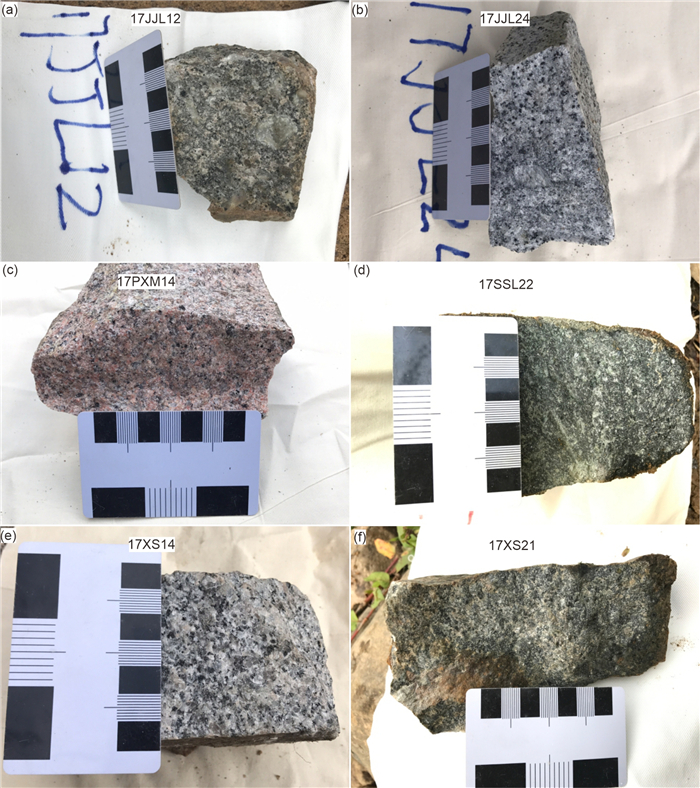
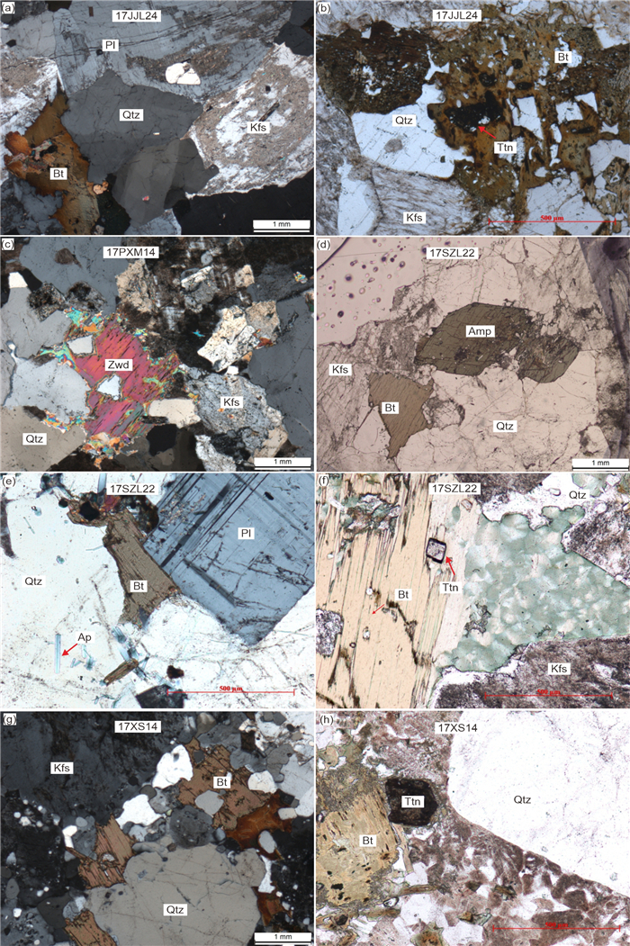
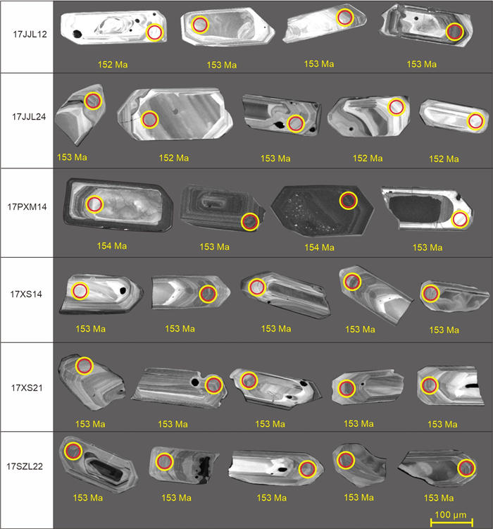
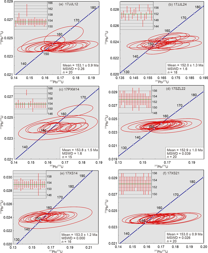
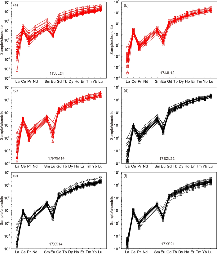
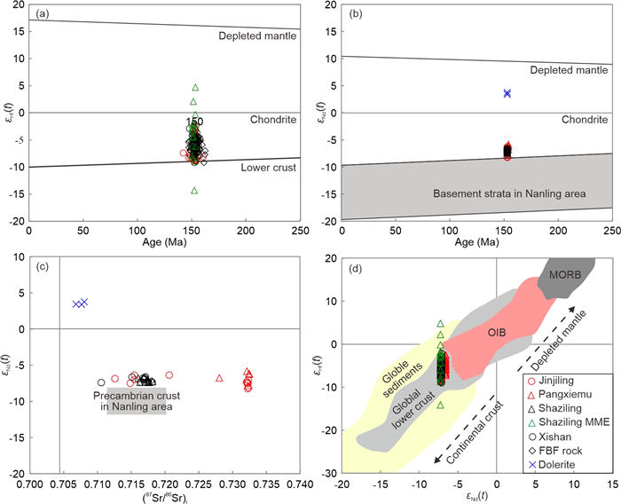
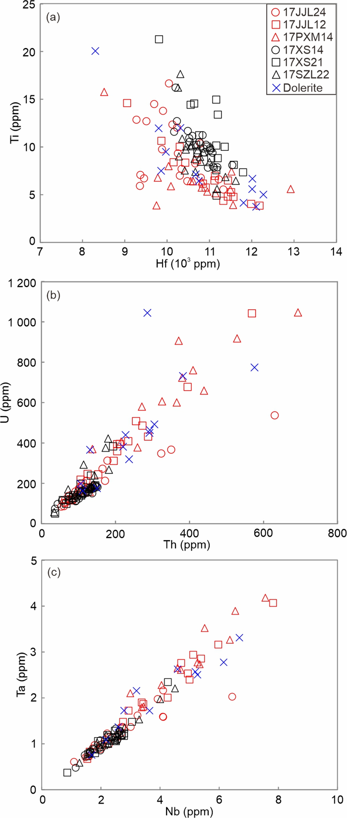
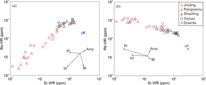
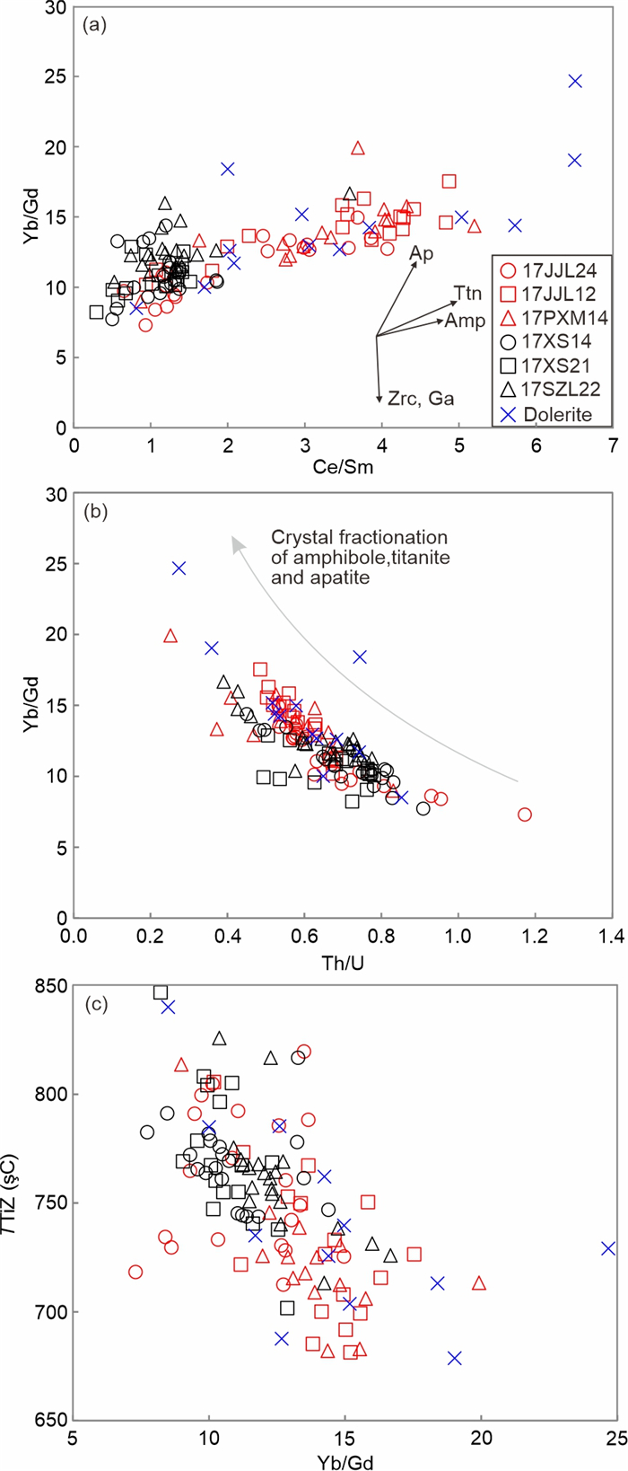
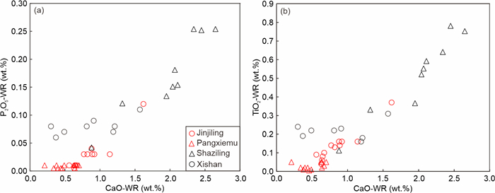
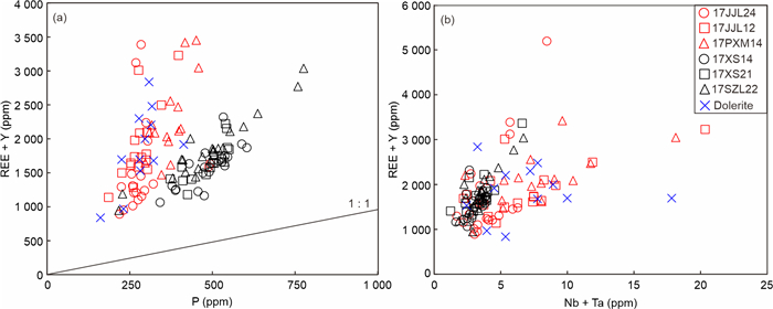
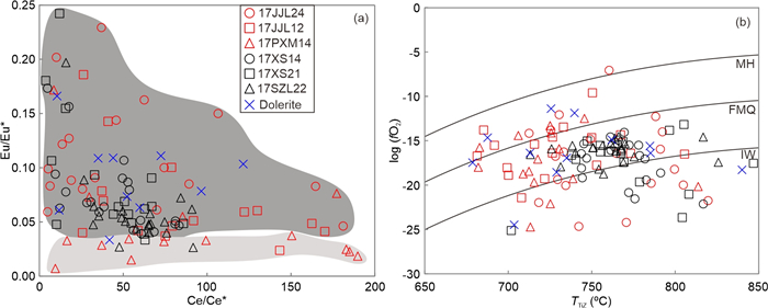
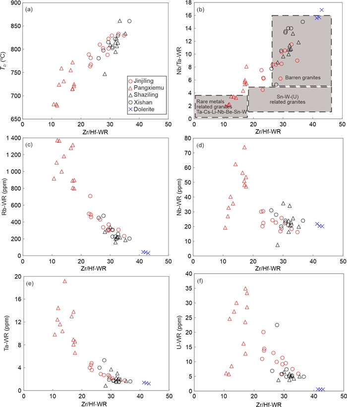
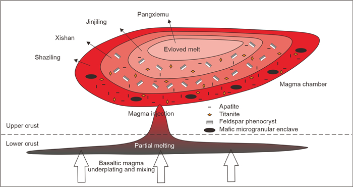
The Jiuyishan granitic complex, located in the Nanling Range, South China, is composed of five granitic plutons (Xuehuading, Jinjiling, Pangxiemu, Shaziling and Xishan). Zircon U-Pb dating of four plutons (Jinjiling, Pangxiemu, Shaziling and Xishan) yielded similar ages of approximately 153 Ma, indicating indistinguishable ages within error. Three plutons except the Shaziling pluton, have consistent εNd(t) (-7.8 to -5.8) and εHf(t) (-9.1 to -2.2) values, which are similar to those of the lower crustal granulitic metasedimentary and meta-igneous rocks in South China. Compared to other three plutons, the Shaziling pluton has consistent εNd(t) (-7.4 to -6.8) and εHf(t) (-7.5 to -4.7) values and shows similar source, but the Shaziling mafic microgranular enclaves (MMEs) show variable εHf(t) (-14.2 to 4.8) values, indicating a remarkable mantle magma injection of the Shaziling pluton. Zircon Ce/Sm-Yb/Gd, whole-rock CaO-P2O5 and CaO-TiO2 linear trends reveal that from the Xishan to the Shaziling and from the Jinjiling to the Pangxiemu granites, they experienced apatite and titanite fractionation, respectively. Zircon Th, U, Nb, Ta, Hf, Ti, Y, P and rare earth element (REE) contents and whole-rock Sr, Ba and Rb contents also show that the Shaziling, Xishan, Jinjiling and Pangxiemu granites followed a discontinuous evolutionary series, but the Pangxiemu granites exhibit highly evolved nature. Four main controlling factors of W-Sn and rare metal mineralization in granitic rocks were discussed, and we found that the mineralization in Jiuyishan granitic complex was mainly controlled by the fractionation degree and crystallization temperature, but were rarely affected by oxygen fugacity and mantle material input. The Pangxiemu granites show particularly higher Rb and Ta contents than the other three plutons, implying that the ore deposits developed in the Jiuyishan Complex were directly related to the most evolved Pangxiemu pluton, with the occurrence of Rb and Ta as the most likely rare metal mineralization in the Jiuyishan District. A crystal mush model is proposed to interpret the petrogenetic and mineralizing processes of the Jiuyishan granitic complex.

Age and Petrogenesis of the newly Discovered Early Permian Granite in the Kumtor Gold Field, Kyrgyz Tien-Shan
Kyiazbek Asilbekov, Rustam Orozbaev, Etienne Skrzypek, Christoph Hauzenberger, Elena Ivleva, Daniela Gallhofer, Jian-Feng Gao, Nikolay Pak, Anatoliy Shevkunov, Anatoliy Bashkirov, Aizat Zhaanbaeva
2025, 36(3): 1090-1108. doi: 10.1007/s12583-024-0085-1
Abstract:

Permian intrusions are widespread in the Middle and Southern Tien-Shan, with fewer occurrences in the Northern Tien-Shan. Notably, many of these intrusions are spatially associated with a variety of ore deposits, indicating a significant link between magmatic activity and mineralization processes in these areas. We studied granite samples recently recovered from drilling in the Kumtor gold field to evaluate their potential relationships with gold mineralization. The major and trace element geochemistry, zircon U-Pb age and Hf isotope data for this so-called Kumtor granite are reported. The Kumtor granite is metaluminous to peraluminous and belongs to the high-K and calc-alkaline series with Ⅰ-type geochemical characteristics. The relatively high K2O and Na2O concentrations and low high field strength elements (HFSE) and heavy rare earth elements (HREE), the presence of biotite within these Ⅰ-type granites, together with their low zircon saturation temperatures (731–779 ℃), suggest that they were likely derived from a hydrous source formed by dehydration melting of mica-bearing, medium- to high-K metabasaltic rocks. The zircon U-Pb dating results indicate that the Kumtor granite intruded at 293 ± 1.7 Ma, which is consistent with the age range of other Middle Tien-Shan granitoids. The zircon Hf isotopic composition is εHf(t) = -7.56 to -5.05, indicating an ancient (1.39 to 1.52 Ga) crustal origin. Petrographical, geochemical and geochronological data indicate that the Kumtor granite is similar to leucogranites of the Terekty Complex. These results indicate that the Kumtor granite was emplaced in the Early Permian in a post-collision setting and may have temporal and genetic relationships with gold mineralization.

Petrolum Geology
Uncover the Diagenetic Water Condition and Dolomite Formation in the Songliao Basin 91 Ma
Yuke Liu, Huajian Wang, Jinyou Zhang, Yuntao Ye, Xiaomei Wang, Shuichang Zhang
2025, 36(3): 1109-1128. doi: 10.1007/s12583-024-0079-z
Abstract:

Lacustrine dolomite is paid increasing attention to uncover the diagenetic water condition of paleo-lake and "dolomite problem". Here, a dolomite nodule from the Qingshankou Formation in the Songliao Basin was analyzed to explore the salinity, alkalinity, and redox conditions of the diagenetic water. Multiple proxies, including bulk boron (B) content, B isotope composition (δ11Bbul), boron to gallium weight ratio (B/Ga) and carbonate oxygen isotope composition (δ18Ocarb), were used to determine the diagenetic water to be brackish-fresh. Through numerical simulation, we calculated the B contents, δ11B values and B/Ga in detritus (e.g., clay, quartz and feldspar) and dolomite as two endmembers, confirming the intense interference of clay minerals on δ11Bbul. By using the fitted δ11B of dolomite endmember (20.6‰), we calculated the pH value of the diagenetic water to be 8.2. The negative δ11B value of detritus endmember (-12.9‰) might be related to the terrestrial weathering. The indicative nature of strontium to barium weight ratio (Sr/Ba) was discussed to deny its applicability as a proxy of salinity in carbonate system. High Sr/Ba ratio in this dolomite nodule indicates a sulfate-poor water condition, consistent with the iron-manganese (Fe-Mn) reduction environments reflected by the Mn/Fe molar ratio. The positive carbonate carbon isotopes (δ13Ccarb, 4.5‰‒9.4‰) indicate that methanogenesis dominated the formation of dolomite, coinciding with the weak sulfate reduction reaction in sulfate-poor water. The growth of dolomite nodule might be related to the microbial activities of methanogen and iron reducing bacteria, which had not only maintained the salinity, pH, and redox status of the diagenetic water, but also led to a ferric-methane transition zone (FMTZ). This research depicts a scenario about the diagenetic water environment of lacustrine dolomite formed in brackish-fresh water, which is different from that occurred in sulfate-rich condition.

Effect of Diagenetic Processes and Depositional Facies on Reservoir Quality of the Eocene Carbonate Sequence (Sakesar Limestone) in the Central Salt Range, Pakistan
Naveed Rehman, Shu Jiang, Syed Haroon Ali, Asim Falak Naz, Muhammad Tariq
2025, 36(3): 1129-1148. doi: 10.1007/s12583-024-0105-1
Abstract:

The effect of depositional facies and diagenesis on the reservoir potential of the Sakesar limestone has been assessed through core plug porosity and permeability data, scanning electron microscope (SEM), and petrographic study in three stratigraphic sections (Karuli, Badshah Pur, and Sardhai) of Central Salt Range. Field observations reveal three lithofacies: thin-bedded limestone with shale intercalation, thick-bedded nodular limestone, and highly fractured limestone. Based on a petrographic study, six microfacies have been identified: bioclastic mudstone facies (SKF-1), Lockhartia-nummulitic wackestone facies (SKF-2), Assilina-Alveolina packstone facies (SKF-3), Lockhartia-nummulitic packstone facies (SKF-4), Alveolina grainstone facies (SKF-5), and nummulitic grainstone facies (SKF-6). The Sakesar limestone shows various diagenetic changes such as compaction, dissolution, dolomitization, cementation, and fracturing, resulting in different types of pores. Two reservoir zones are identified in the Sakesar limestone: a mud-dominated reservoir in an outer ramp setting with interparticle and micropores and a bioclastic grain-dominated facies in an inner ramp setting with intraskeletal and fracture porosity. The porosity and permeability of grain-dominated facies (8%–30% and 0.8–8 mD) are higher than mud-dominated facies (4%–15% and 0.5–4 mD) due to intraskeletal/intraparticle pores and dolomitization.

Model of Tight Conglomerate Oil Accumulation in the Mahu Sag, Junggar Basin, Northwest China
Weitao Wu, Yong Tang, Jingzhou Zhao, Tao Wu, Heyuan Wu
2025, 36(3): 1149-1167. doi: 10.1007/s12583-023-1840-4
Abstract:

Research based on oil accumulation models is essential for exploring the hydrocarbon accumulation theory further. Studies on tight oil accumulation models focused on fan delta depositional systems, and in particular, systems involving source-reservoir separated type are scarce. To explore the accumulation model of tight oil in conglomerate, this study focused on the Permian– Triassic tight conglomerate oil in Mahu sag, Junggar Basin, using well drilling, well logging, seismic profiling, oil testing, and laboratory data, and analyzed the formation conditions, formation types, and distribution patterns of conglomerate reservoirs. The results show that, the conglomerate reservoirs are predominantly lithologic reservoirs and partly fault-lithologic reservoirs; there is no water evident at the edge or bottom around the reservoirs. The tight conglomerate layer in the delta plain subfacies of each fan exhibits high clay content and intense diagenesis, and the argillaceous rocks in the pro-fan delta subfacies and shallow lacustrine facies form the sealing and floor conditions. The sandy conglomerate of fan delta front subfacies is the main reservoir body. Additionally, strike-slip faulting in the Indosinian-Himalayan period formed an efficient faulting system for trans-stratal migration with Hercynian-Indosinian inverse faulting. Oil migration is driven by the overpressure caused by hydrocarbon generation from alkali lacustrine source rocks. The distribution of reservoirs is primarily controlled by the large fan bodies, namely the Zhongguai, Baijiantan, Karamay, Huangyangquan, Xiazijie, Xiayan, and Dabasong fans. Each fan body forms a group of reservoirs or oilfields, resulting in a widely distributed pattern, according to which reservoir and sealing constitute one whole body—i.e., patterns of "one sand and one reservoir, one fan and one field." This results in a quasi-continuous accumulation model, which includes strong oil charging, efficient faulting transportation, trans-stratal migration, and lithologic trapped accumulation. The proposed model is an important supplement to the existing model of quasi-continuous oil and gas accumulation. Overall, this study enriches unconventional oil and gas accumulation theories.

Engineering Geology and Geohazards
Susceptibility Mapping of Ground Collapse Caused by Anthropogenic Activities
Zhongmin Mao, Yuyong Jiao, Fei Tan, Qi Xin, Zeng Cong
2025, 36(3): 1168-1180. doi: 10.1007/s12583-022-1644-y
Abstract:

With the rapid urbanization process, ground collapses caused by anthropogenic activities occur frequently. Accurate susceptibility mapping is of great significance for disaster prevention and control. In this study, 1 198 ground collapse cases in Shenzhen from 2017 to 2020 were collected. Eight effective factors (elevation, relief, clay proportion, average annual precipitation, distance from water, land use type, building density, and road density) were selected to construct the evaluation index system. Ground collapse susceptibility was analyzed and mapped using the normalized frequency ratio (NFR), logistic regression (LR), and NFR-LR coupling models. Finally, the result rationality and performance of the three models were compared through frequency ratio (FR) and ROC curve. The results indicate that all three models can effectively evaluate the ground collapse susceptibility (AUC > 0.7), and the NFR-LR model result is more rational and has the best performance (AUC = 0.791). The very high and high susceptibility zones cover a total area of 545.68 km2 and involve Nanshan, Luohu, and Futian District, as well as some areas of Baoan, Guangming, and Longgang District. The ground collapses in Shenzhen mainly occurred in the built-up areas, and the greater intensity of anthropogenic activities, the more susceptible to the disaster.

Characteristics of Massive Glacier-Related Watershed Geohazard Chains in the Eastern Himalayan Syntaxis, China
Shaohua Gao, Yang Gao, Yueping Yin, Bin Li, Wenpei Wang, Tiantian Zhang, Haoyuan Gao
2025, 36(3): 1181-1197. doi: 10.1007/s12583-024-0116-y
Abstract:

Frequent glacier-related watershed geohazard chains are causing severe damage to life and infrastructure, reported consistently from the Eastern Himalayan Syntaxis. This paper presents a systematic method for researching geohazard, from regional to individual scale. The methodology includes the establishment of geological chain inventories, discrimination of geohazard chain modes, analyses of dynamics and dam breaches, and risk assessments. The following results were obtained: (1) In the downstream of Yarlung Zangbo River, 175 sites were identified as high-risk for river blockage disasters, indicating the development of watershed geohazards. Five geohazard chain modes were summarized by incorporating geomorphological characteristics, historical events, landslide zoning, and materials. The risk areas of typical hazard were identified and assessed using InSAR data. (2) Glacier-related watershed geohazard chains are significantly different from traditional landslides. A detailed inversion analysis was conducted on the massive rock-ice avalanche in the Sedongpu gully in 2021. This particular event lasted roughly 300 seconds, with a maximum flow velocity of 77.2 m/s and a maximum flow height of 93 meters. By scrutinizing the dynamic processes and mechanical characteristics, mobility stages and phase transitions can be divided into four stages. (3) Watershed geohazard chains tend to block rivers. The peak breach discharge of the Yigong Landslide reached 12.4 × 10⁴ m3/s, which is 36 times the volume of the seasonal flood discharge in the Yigong River. Megafloods caused by landslide dam breaches have significantly shaped the geomorphology. This study offers insights into disaster patterns and the multi-staged movement characteristics of glacier-related watershed geohazard chains, providing a comprehensive method for investigations and assessments in glacial regions.

Hydrologic Characteristics and Settlement Deformation of Backfilled Loess in Yan'an, China
Lina Ma, Shengwen Qi, Songfeng Guo
2025, 36(3): 1198-1212. doi: 10.1007/s12583-024-1990-z
Abstract:

A gigantic project named Gully Land Consolidation (GLC) was launched in the hill- gully region of the Chinese Loess Plateau in 2011 to cope with land degradation and create new farmlands for cultivation. The dynamic change of groundwater table and loess subsidence in the backfilled farmland are the main causes of site disasters and soil disease, but there is a lack of research on these issues. Based on this, the Shijiagou (SJG) backfilled farmland which is a typical GLC engineering site located in Ansai District, Yan'an City, Shaanxi Province was selected as the study area in this paper. Field site monitoring was carried out in this area, including four aspects of monitoring: rainfall, groundwater table, soil moisture and soil settlement displacement. The following findings were obtained from the analysis of the monitoring data in 2019–2020: (1) The backfilled farmlands have suffered a significant groundwater table rise. And the percentage increase of groundwater table increased from the upstream of F-1 (such as 49.2%, 46.3%, 26.4%) to the downstream of F-5 (90.0%, 52.3%, 34.2% correspondingly), which is related to the terrain of the valley channel and dam seepage. It is also revealed that rainfall characteristics are positively correlated with the depth of water infiltration and groundwater table. (2) The influence depth of rainfall infiltration on soil moisture of the backfilled loess in the GLC study area is no more than 2.5 m, and that within 1.5 m depth is significantly affected by rainfall. In addition, the dramatic rise in the groundwater table led to a steep increase in soil moisture, thus the soil underwent collapse deformation due to water immersion, and the farmland experienced large subsidence displacement. (3) The backfilled loess of the GLC farmland was in a continuous consolidation and settlement stage after the filling completion. With the passage of time, the settlement displacement and settlement rate of the backfilled loess gradually decreased, from 1.0–1.9 mm/d in 2019 to 0.4–0.8 mm/d in 2020, which indicates the GLC farmland tended to be stable. This study reveals the hydrological evolution characteristics and settlement deformation laws of the backfilled loess, which is important for the stability of the farmland and the management of the GLC project.

Hydrogeology and Environmental Geology
Flow Variations and Circulation Process of Saline Springs in the Nangqen Basin, Tibetan Plateau
Jibin Han, Jianping Wang, Hongkui Ma, Yongshou Li, Zhao An, Yong Xiao, Wenhua Han, Huaide Cheng, Haizhou Ma, Hongchen Jiang
2025, 36(3): 1213-1225. doi: 10.1007/s12583-024-0086-0
Abstract:

There was limited knowledge about the flow fluctuations and cycling processes of saline springs in the Nangqen Basin in the Sanjiang tectonic zone. In this work, the flow variations of the saline springs during the wet and dry seasons were monitored using volumetric and cross-sectional methods, and the cycling process of the saline springs was quantitatively identified using the integrated hydrochemical and isotopic methods. The results show that most saline springs in the Nangqen Basin had significantly different flow rates, ion concentrations, and TDS concentrations. The ions mainly come from carbonate and sulfate minerals. There is no internal hydraulic connection between these saline springs, and the impact of seasonal changes on the flow is relatively small, indicating that the saline springs originate mainly from deep circulation. The recharge elevation of the saline springs ranges 3 661–4 990 m a.s.l., with an average of 4 100 m a.s.l. The circulation depth of the saline springs ranges of 240–570 m, with an average of 431 m. The recycle time ranges of 1.15–30.86 years, with an average of 15.66 years. These results could provide a scientific basis for the development and utilization of saline spring resources in the Nangqen Basin.

Freezing-Induced Redistribution of Fe(Ⅱ) Species within Clay Minerals  for Nonlinear Variations in Hydroxyl Radical Yield and Contaminant Degradation
Dong Yu, Hongbin Peng, Chenglong Yu, Wenwen Ji, Xin Wang, Shengyan Pu
2025, 36(3): 1226-1235. doi: 10.1007/s12583-024-0119-8
Abstract:

Hydroxyl radical (•OH) formation from Fe(Ⅱ)-bearing clay mineral oxygenation in the shallow subsurface has been well documented under moderate environmental conditions. However, the impact of freezing processes on the •OH production capability of Fe(Ⅱ)-bearing clay minerals for organic contaminant degradation, particularly in seasonally frozen soils, remains unclear. In this study, we investigated the influence of pre-freezing durations on the mineral proprieties, •OH production, and phenol degradation during the oxygenation of reduced Fe-rich nontronite (rNAu-2) and Fe-poor montmorillonite (rSWy-3). During the freezing process of reduced clay minerals (1 mM Fe(Ⅱ)), the content of edge surface Fe and Fe(Ⅱ) decreased by up to 46% and 58%, respectively, followed by a slight increased as clay mineral particles aggregated and subsequently partially disaggregated. As the edge surface Fe(Ⅱ) is effective in O2 activation but less effective in the transformation of H2O2 to •OH, the redistribution of edge surface Fe(Ⅱ) leads to that •OH production and phenol degradation increased initially and then decreased with pre-freezing durations ranging from 0 to 20 days. Moreover, the rate constants of phenol degradation for both the rapid and slow reaction phases also first increase and then decrease with freezing time. However, pre-freezing significantly influenced the rapid phase of phenol degradation by rNAu-2 but affected the slow phase by rSWy-3 due to the much higher edge-surface Fe(Ⅱ) content in rNAu-2. Overall, these findings provide novel insights into the mechanism of •OH production and contaminant degradation during the freeze-thaw processes in clay-rich soils.

Eocene Weathering Oscillations Imprinted in Marl Mineral and Geochemical Record, Dinaric Foreland Basin, Croatia
Marija Horvat, Nenad Tomašić, Dunja Aljinović, Damir Bucković, Stjepan Ćorić, Vlasta Ćosović, Igor Felja, Ines Galović, Željko Ištuk, Štefica Kampić, Dražen Kurtanjek, Đurđica Pezelj
2025, 36(3): 1236-1250. doi: 10.1007/s12583-023-1913-2
Abstract:

Hemipelagic to pelagic (H/P) marls, representing pelitic deposits, accumulated within the foredeep sub-basin of the Dinaric Foreland Basin (northern Neotethyan margin, present-day Croatia) during the Middle to Late Eocene. Syn-sedimentary tectonic movements, paleogeographic position and exchanges of short-lived hyperthermal episodes affected the sedimentation and related mineral and geochemical record of these deposits. Mineral (clay) assemblages bear signature of prevailing physical weathering with significant illite and chlorite content, but climatic seasonality is suggested by smectite-interlayered phases and sporadical increase of kaolinite content. Illite crystallinity varies significantly, and the lowest crystallinity is recorded by the Lutetian samples. Illite chemistry index is always bellow 0.5, being characteristic for Fe-Mg-rich illite. The geochemical records are the most prominent (CIA up to 76, CIW up to 91) for the Istrian Lutetian (42.3–40.5 Ma), but also for Priabonian (35.8–34.3 Ma) samples of Hvar Island. The ICV values (the lowest 1.40 and the highest 10.85) of all studied samples fall above PAAS (ICV = 0.85) and point to their chemical immaturity. The Ga/Rb ratios are lower than 0.2 and K2O/Al2O3 ratios are also low (0.16–0.22), implying transition between cold and dry, and warm and humid climate, obviously trending among several warming episodes.

Half-Precessional Cycle Revealed by Environment Magnetism of Stalagmite in Shizhu Cave from Southwestern China during the Last Glacial
Huihui Yang, Yu-Min Chou, Xiuyang Jiang, Wenyue Xia, Hai Li, Yi Zhong, Jingyu Zhang, Yaoqi He, Tsai-Luen Yu, Qingsong Liu, Chuan-Chou Shen
2025, 36(3): 1251-1260. doi: 10.1007/s12583-024-0005-4
Abstract:

The environmental magnetic proxies of stalagmites hold significant potential for reconstructing regional hydroclimate changes by revealing the content and grain size of magnetic particles within stalagmites. In this study, we present the contents and grain sizes of magnetic particles within a stalagmite SZ-1, from Shizhu Cave in southwestern China from 70.4 to 22.3 thousand years ago (ka) during the last glacial period. Specifically, the parameters IRMsoft, soil-derived magnetic minerals, and ARM/SIRM (anhysteretic remanent magnetization/saturation isothermal remanent magnetization), the ratio of fine magnetic particles to total ferrimagnetic particles preserved in stalagmite SZ-1, indicate the fluctuation of regional precipitation. Obvious half-precessional cycles are evident in these two proxies, indicating that hydroclimatic variations in southwestern China may predominantly arise from the heat and moisture transported from tropical oceans. These variations are likely influenced by shifts in the Intertropical Convergence Zone and fluctuations in the Asian Summer Monsoon.

Big Data Geosciences
Machine Learning of Element Geochemical Anomalies for Adverse Geology Identification in Tunnels
Ruiqi Shao, Peng Lin, Zhenhao Xu, Fumin Liu, Yilong Liu
2025, 36(3): 1261-1276. doi: 10.1007/s12583-024-0090-4
Abstract:

Geological analysis, despite being a long-term method for identifying adverse geology in tunnels, has significant limitations due to its reliance on empirical analysis. The quantitative aspects of geochemical anomalies associated with adverse geology provide a novel strategy for addressing these limitations. However, statistical methods for identifying geochemical anomalies are insufficient for tunnel engineering. In contrast, data mining techniques such as machine learning have demonstrated greater efficacy when applied to geological data. Herein, a method for identifying adverse geology using machine learning of geochemical anomalies is proposed. The method was identified geochemical anomalies in tunnel that were not identified by statistical methods. We by employing robust factor analysis and self-organizing maps to reduce the dimensionality of geochemical data and extract the anomaly elements combination (AEC). Using the AEC sample data, we trained an isolation forest model to identify the multi-element anomalies, successfully. We analyzed the adverse geological features based the multi-element anomalies. This study, therefore, extends the traditional approach of geological analysis in tunnels and demonstrates that machine learning is an effective tool for intelligent geological analysis. Correspondingly, the research offers new insights regarding the adverse geology and the prevention of hazards during the construction of tunnels and underground engineering projects.

Machine Learning Discovers South American Subduction Zone Hotter than previously Predicted
Junjie Ji, Qiuming Cheng, Yang Zhang, Yuanzhi Zhou, Tao Hong
2025, 36(3): 1277-1289. doi: 10.1007/s12583-025-0222-5
Abstract:

Geothermal heat flow (GHF) is crucial for characterizing the Earth's thermal state. Compared to other regions worldwide, GHF measurements of South America are relatively sparse for mapping GHF over the continent based on traditional models. Here we apply the machine learning (ML) techniques to predict the GHF in South America. By comparing the global model, ML finds that South American subduction zones are hotter than the global model due to large-scale magmatism, which leads to the higher shallow arc temperatures than canonical thermomechanical and global models. Combining ML model with the local singularity analysis of heat flows, active volcanoes, and igneous rock samples, it is suggested that geothermal anomalies along the Andean Mountain Range are spatially correlated with magmatic activity in the subduction zone. It is concluded that the ML methods may provide reliable GHF prediction in regions like South America, where GHF measurements are limited and uneven.

Editorials
Meso–Cenozoic Tectonic and Thermal History of the Kuqa Depression, Tarim Basin: Insights from Low-Temperature Thermochronology and Vitrinite Reflectance
Wenhao Xia, Jiyuan Yin, Zhiyuan He, Stuart N. Thomson, Fucheng Tan, Yamei Wang
2025, 36(3): 1290-1296. doi: 10.1007/s12583-025-2027-y
Abstract:
Coupled Sulfur and Carbon Transfer via Diverse Species in Deep Subduction-Zone Fluids Revealed by Diamond-Facies Fluid Inclusions
Chenhui Fei, Shun Guo, Yibing Li, Xiaoguang Li, Jingbo Liu
2025, 36(3): 1297-1302. doi: 10.1007/s12583-025-2037-9
Abstract:
Alteration and Metallogenic Zonation in Magmatic-Hydrothermal Ore Systems: Scientific Understandings and Exploration Implications
Degao Zhai, Jinchao Wu, Qingqing Zhao, Panagiotis Voudouris, Stylianos Tombros, Xinli Wang, Wangjie Chen, Jinghao Sun, Zhan Xu, Jiajun Liu
2025, 36(3): 1303-1308. doi: 10.1007/s12583-025-2034-z
Abstract:
Newly Discovered High-Sulfidation Mineralization in the Yueyang Silver-Polymetallic Deposit, Zijinshan Ore Field, and Implications for Mineral Exploration
Jieyi Li, Wenyuan Liu, Hua Long, Jingwen Chen, Jianhuan Qiu, Xiaodan Lai, Guiqing Xie
2025, 36(3): 1309-1314. doi: 10.1007/s12583-025-2036-x
Abstract:
What Controls Oil Saturation in Fractures?
Chen Zhang, Shu Jiang, Xiangye Kong, Zhenxue Jiang, Yan Song, Yixin Dong, Qun Luo, Kaihui Song, Kun Zhang, Feifan Lu
2025, 36(3): 1315-1319. doi: 10.1007/s12583-025-2030-3
Abstract:
An Improved Slip Circle Method for Evaluating the Stability of Submarine Landslides under Wave Loading
Miaojun Sun, Zhigang Shan, Changdong Li, Jiaqing Zhou, Qingbing Liu, Xinji Zou, Qilong Li, Biwen Dong
2025, 36(3): 1320-1326. doi: 10.1007/s12583-025-2028-x
Abstract:
UAV-Based Thermal Infrared Imaging Technology: A Novel Approach for Rapid Investigation of High-Steep Slopes
Han Yin, Wen Zhang, Jia Wang, Junqi Chen, Chen Cao, Qi Sun, Tengyue Li, Bo Han
2025, 36(3): 1327-1333. doi: 10.1007/s12583-025-2031-2
Abstract:
Advancements in Laboratory Studies of Layered Rock Masses for Deep Engineering: Insights and Future Perspectives
Yan Zhang, Kai Meng, Xuanmei Fan, Guoqing Chen, Xiangsheng Zheng, Shaojun Li, Tianbin Li, Peng Zeng, Min Xia
2025, 36(3): 1334-1340. doi: 10.1007/s12583-025-2032-1
Abstract:
Dynamic Rockfall Hazard Assessment at Railway Tunnel Portal: Application of G1-FCE Method and 3D Numerical Simulation
Shengwei Zhang, Jiaxing Dong, Yanjun Shen, Qingjun Zuo, Junli Wan
2025, 36(3): 1341-1347. doi: 10.1007/s12583-025-2035-y
Abstract:
Recent Vegetation Shifts on the Tibetan Plateau Exceed the Range of Variations Seen over Past Millennia in Pollen Record
Kai Yi, Xianyong Cao
2025, 36(3): 1348-1350. doi: 10.1007/s12583-025-2029-9
Abstract:
Warming-Induced Increase in Flooding in the Taklimakan Desert
Yanan Su, Xin Wang, Xiangjun Luo, Shengqian Chen, Yaqi Chen, Fan Yang, Jiaqiang Lei, Fahu Chen
2025, 36(3): 1351-1354. doi: 10.1007/s12583-025-2033-0
Abstract: