Processing math: 100%
Advanced Search

Indexed by SCI、CA、РЖ、PA、CSA、ZR、etc .

Jibin Han, Jianxin Xu, Lei Yi, Zheng Chang, Jianping Wang, Haizhou Ma, Baoyun Zhang, Hongchen Jiang. Seasonal Interaction of River Water-Groundwater-Salt Lake Brine and Its Influence on Water-Salt Balance in the Nalenggele River Catchment in Qaidam Basin, NW China. Journal of Earth Science, 2022, 33(5): 1298-1308. doi: 10.1007/s12583-022-1731-0
Citation: Jibin Han, Jianxin Xu, Lei Yi, Zheng Chang, Jianping Wang, Haizhou Ma, Baoyun Zhang, Hongchen Jiang. Seasonal Interaction of River Water-Groundwater-Salt Lake Brine and Its Influence on Water-Salt Balance in the Nalenggele River Catchment in Qaidam Basin, NW China. Journal of Earth Science, 2022, 33(5): 1298-1308. doi: 10.1007/s12583-022-1731-0

Seasonal Interaction of River Water-Groundwater-Salt Lake Brine and Its Influence on Water-Salt Balance in the Nalenggele River Catchment in Qaidam Basin, NW China

doi: 10.1007/s12583-022-1731-0
More Information
  • Corresponding author: Jibin Han, jbhan@isl.ac.cn; Hongchen Jiang, jiangh@cug.edu.cn
  • Received Date: 10 Nov 2021
  • Accepted Date: 06 Aug 2022
  • Available Online: 19 Oct 2022
  • Issue Publish Date: 30 Oct 2022
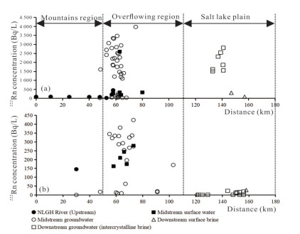
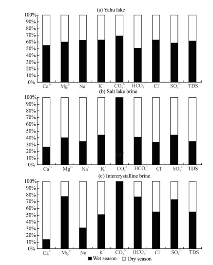
  • Identifying interactions among river water, groundwater and salt lake brine is important for sustainable exploitation of brine mineral resources. In this study, we investigated the water exchange rate in dry and wet seasons, and assessed the influence of seasonal water exchange on brine concentration and crystallization process in the Nalenggele (NLGL) catchment of Qaidam Basin, China. The results show that the surface water infiltration and groundwater recharge rates in the wet season were 2.81 × 10⁻³ and 1.15 × 10⁻³ m3/(s·m) in upstream, 1.63 × 10⁻² and 1.53 × 10⁻² m3/(s·m) in midstream, and 2.83 × 10⁻⁴ and 6.82 × 10⁻⁵ m3/(s·m) in downstream, respectively; while their counterparts in the dry season were 9.81 × 10⁻⁴ and 5.05 × 10⁻⁴ m3/(s·m) in upstream, and 8.34 × 10⁻³ and 7.78 × 10⁻³ m3/(s·m) in midstream, respectively. The water exchange strongly influenced brine concentration and crystallinzation process, with brine chemistry belonging to 3K2SO4·Na2SO4 and KCl types in wet and dry seasons, respectively. The strong water exchange in wet season destroyed the water-salt balance, while the low water exchange rate in dry season facilitated preparation of KCl products.


  • Electronic Supplementary Materials: Supplementary materials (Figs. S1, S2, Table S1) are available in the online version of this article at https://doi.org/10.1007/s12583-022-1731-0.
  • Interactions between river water and groundwater are common in river basins (Bouchez et al., 2021; Wang et al., 2021; Yang et al., 2021). Study of this interaction is of great significance to assessing groundwater budget and water resources allocation (Xu et al., 2017; Wang et al., 2016; Su et al., 2015; Cook et al., 2006; Batelaan et al., 2003). In arid and semi-arid regions, the characteristics of river water and groundwater vary greatly between wet season (WS) and dry season (DS) (Jia et al., 2021; Yang et al., 2021). Groundwater and river water support fragile ecosystems and human activities in arid and semi-arid regions (Wang et al., 2021; Yin et al., 2021; Zhang et al., 2021; Xu et al., 2017). Modern salt lakes are located in the catchment basin. The inflowing river water and the groundwater in the catchment area are finally supplied to the salt lake. They not only provide the water source for the salt lake, but also (Zhang, 1987). In the salt lake plain, there is usually interactions among river water, groundwater and salt lake brine, which are significantly different between wet season and dry season. This interaction maintains the water-salt balance in the salt lake area (Bischoff et al., 2004; Yu, 1995), and is necessary for sustainable brine mining of the salt industry.

    Qaidam Basin, located in northwestern China, is a super arid basin with an area of 121 × 103 km2 (Yu et al., 2013). There are 25 salt lakes in Qaidam Basin, and these salt lakes possess abundant brine deposits, such as KCl and LiCl (Han et al., 2021; Wei et al., 2014; Tan et al., 2012). Among these salt lakes, Dong-Xi Taijinaer Salt Lake (DXTSL), with an average elevation of 2 860 m above sea level (m.a.s.l.) is the largest LiCl mine in China. The DXTSL is fed by Nalenggele (NLGL) River that originates from the east of Kunlun Mountain with an average elevation of 4 500 m.a.s.l. The annual water supply of the NLGL River is about 10.0 × 10⁸ m3, which can be used for local ecology, agriculture and animal husbandry, domestic water, and salt chemical industry. The DXTSL area needs about 5.95×10⁸ and 2.4×10⁸ m3/a water resources to sustain the salt lake area and water-salt balance, respectively (Shi et al., 2021). The amount of brine used for the production of LiCl is up to 2.0×10⁸ m3/a (Han et al., 2020). However, the water consumption and brine extraction of salt chemical industry are increasing in recent years, resulting in the intensification of contradiction between supply and demand of water resources (Han et al., 2020; Guo et al., 2012). Besides, the runoff of the NLGL River varies greatly between wet (June, July, August) and dry seasons (January, February, December): in the wet season, floods often occur and discharge into salt lakes, leading to the destruction of water-salt balance. In recent years, climate warming leads to increase of atmospheric precipitation (Liu et al., 2021; Lu, 2014; Fu et al., 2011), so that floods in summer have seriously destroyed salt minerals (dissolution, decreasing grade, the ground collapsed) in the Qaidam Basin. However, so far limited is known about the interactions among river water, groundwater and the DXTSL, the quantity of river water and groundwater inflowing fluxes to the DXTSL in wet and dry seasons, and its influence for the salt lake brine concentration and brine crystallization process. Such knowledge is of great importance for understanding of water-salt balance and sustainable exploitation of brine in the DXTSL.

    Various methods and techniques have been developed to study water source identification, hydrologic dynamics, and water quality and water exchange characteristics (Qin et al., 2021; Zhang et al., 2021a, b; Wu et al., 2020; Liao et al., 2018; Zhao et al., 2018; Xu et al., 2017; Stellato et al., 2008). Among these methods and techniques, radioactive isotope 222Rn is a natural conservative tracer, which has recently been widely employed to investigate exchange between groundwater and river water (Oh et al., 2021; Dimova et al., 2013; Santos et al., 2010; Cook et al., 2003), especially in arid and semi-arid areas (Yang et al., 2021; Zhao et al., 2018; Xu et al., 2017; Su et al., 2015). The concentration of 222Rn in groundwater is higher than that in river water (Ortega et al., 2015; Dimova and Burnett, 2011). This distinct difference enables researchers to identify the interaction between groundwater and river water during wet and dry seasons. Stable isotopes of hydrogen (D) and oxygen (18O) carry the information of water circulation, and thus can be used to determine the rate of supply to discharge, which makes these two common stable isotopes very useful for determining the sources of different types of water. Such methods have been widely used in hydrological and hydrogeological studies in recent decades (Zhao et al., 2018; Xu et al., 2017; Gu et al., 2011; Gat 2010; Kendall and McDonnell, 1998; Clark and Fritz, 1997).

    In this study, we investigated the contributions of groundwater, river water to the brine of DXTSL along the NLGL River from upstream to downstream in wet and dry seasons, and their impacts on salt minerals. The aims of this study were to 1) quantitatively identify the interactions among the groundwater, river water and salt lake in wet and dry seasons; and 2) assess the influence of water exchange on brine concentration and brine crystallization process.

    The NLGL River is the largest river in Qaidam Basin, northeasten Tibetan Plateau (Fig. 1a), and its runoff is 528.0 and 4.03 m3/s in wet and dry seasons, respectively, with an average of 13.66×10⁸ m3/year; the runoff of the NLGL River in wet season accounted for 74% of annual average runoff (Xu, 2015). In the DXTSL region, rainfall mainly occurs in summer, with average precipitation of less than 30 mm/a and average evaporation of larger than 2 700 mm/a (Xu and Su, 2019; Yu et al., 2013). The average temperature is approximately 3.0 ℃/year, with maximum and minimum temperature of 35.3 and -29.5 ℃, respectively (Xu et al., 2017).

    Figure  1.  Location of the study area on the Tibetan Plateau (a); and sampling sites in the wet season and dry season (b).

    The main bedrock types in the source area (upstream) of the NLGL River mainly consists of granodiorite, plagioclase granite and quartz diorite (Tan et al., 2012), which mainly contain bedrock fissure water (Rong et al., 2002). In the middle reaches, the NLGL River widens sharply after flowing out of the Kunlun Mountains, forming a huge foreland alluvial fan (I), which is rich in sedimentary sand, sandy clay and gravel. From the root to the edge of the fan I, the aquifer medium changes from single-layer to multi-layer, with the aquifer thickness changing from 20 to 165 m, the phreatic depth changing from about 100 to 3 m, and the permeability coefficient changing from 54.95 to 98.49 m/d. At the fan root, the aquifer is thick and widely distributed, with abundant groundwater (Tai, 2015; Xu, 2015); while at the edge of the fan there is confined aquifer, with a thickness of 10–50 m and less groundwater (Xu, 2015; Rong et al., 2002). In the midstream, the river water exchanges frequently with groundwater. In the downstream (fan II), river water disappears in winter and is remained at a high level in summer; the DXTSL is mainly recharged by groundwater. The sedimentary lithology of the aquifers is sand, sand with salt, and salt for the fan root, fan front, and the salt plain, respectively (Han et al., 2020). From the root to the edge of the fan II, the aquifer also changes from single-layer to multi- layer, which is filled with pore water (brine). In the salt lake plain area, the phreatic aquifer dominates, and its thickness gradually increases from the fan root (south) to the fan edge (north) (the thickness range is 2.0–8.2 m), and the water outflow from single wells increases from south to north, with the maximum value of 1 108.51 m3/d. This indicates that the salt lake plain area is rich in intergranular brine. The confined aquifer is only distributed in the center of the salt lake basin, with a depth of 7.0–9.0 m from the surface, a thickness of 10.0–25.0 m and a maximum water outflow of 182.47 m3/d from single wells. This suggests that there is less intercrystalline brine in the center of the salt lake basin (Rong et al., 2002).

    Sampling cruises were performed along the NLGL River from upstream to downstream in July (wet season) and December (dry season) (Fig. 1b) of 2020. River water and brine samples were directly collected in the NLGL River and DXTSL, respectively; and groundwater samples were collected from phreatic water wells (15–25 m) and artesian wells (80–150 m) (Fig. 1b). In the field, the 222Rn activity of the water samples were measured by using a portable radon instrumentation RAD7-H2O (Durridge, USA) via α-decay accounts. After field measurements, river water samples and salt lake brine samples were collected at the depth of about 10–20 cm below the water surface. The groundwater samples of artesian wells were directly collected into 500 mL bottles. The groundwater samples were collected from phreatic wells after pumping out at least five times the volume of stagnant water in the borehole. The spring water samples were extracted by using a peristaltic pump and air bubbles were removed as much as possible to ensure that the pumped water was representative. Intercrystalline brine samples were collected from the salt layer at the depth of about 50–150 cm below the lakebed. A total of 68 water samples were collected in July 2020, including 8 from the upstream NLGL River, 10 from branches in the mid-downstream, 41 from groundwater, 2 from salt lake brine, and 7 from intercrystalline brine (Fig. 1b); A total of 73 water samples were collected in Dec. 2020, including 1 from the upper stream of NLGL River, 11 from branches in the mid-lower stream, 31 from groundwater in alluvial fan I, 5 from salt lake brine, and 15 from intercrystalline brine in alluvial fan II (Fig. 1b).

    Chemistry measurements of the collected water samples were carried out at the Qinghai Institute of Salt Lakes, Chinese Academy of Sciences. The contents of Ca2+, Mg2+, Na+, and K+ were determined by inductively coupled plasma optical emission spectrometry (ICP-OES) (IRIS Intrepid II XSP, Thermo Elemental, Madison, WI, USA) (error < ±1%), and the concentrations of SO42- and Cl- were determined by ion chromatography (IC) (Dionex 120, Dionex, Sunnyvale, CA, USA) (error < ±5%) (Han et al., 2018). The contents of HCO3- and CO32- were analyzed by using hydrochloric acid titration with phenolphthalein and the mixed solution of methylene blue and methyl red as indicators (error < ±1%) (Han et al., 2018). The δ2H, δ18O isotopes of water samples were analyzed at the Institute of Hydrogeology and Environmental Geology, Shijiazhuang. The isotopes of δ2H (Zn reduction method) and δ18O (CO2-H2O method) were measured with Picarro L2130-i Isotope Analyzer, the measurement resolution of δ2H and δ18O isotopes is δD- VSMOW (Vienna Standard Mean Ocean Water) (‰) ≤ ±1.0‰ and δ18O-VSMOW(‰) ≤ ±0.2‰, respectively.

    The hydrochemistry data were shown in Table 1. During wet season (WS), in the upstream, Na+ and Ca2+ were the dominant cations in river water, with concentration ranging 35.7–148.2 and 119.9–258.4 mg/L (average: 55.8 and 165.5 mg/L), respectively; Cl- and SO42- were the major anions in river water, with concentration ranging 192.5–373.2 and 65.41–424.3 mg/L (average: 251.1 and 129.79 mg/L), respectively. In the midstream, Na+ was the dominant cation in river water, with concentration ranging 143.8–459.2 mg/L (average: 233.4 mg/L); and Cl- was the major anion in river water, with concentration ranging 205.5–668.8 mg/L (average: 348.1 mg/L). Na+ was the dominant cation in groundwater, with concentration ranging 137.4–615.0 mg/L (average: 202.3 mg/L); and Cl- was the major anion in groundwater, with concentration ranging 212.6–992.2 mg/L (average: 308.1 mg/L). In the downstream, Na+ and Cl- were the dominant ions in the salt lake brine, with concentration ranging 2 141.0–115 106.0 mg/L (average: 58 623.0 mg/L) and 3 375.0–180 818.0 mg/L (average: 92 097.0 mg/L), respectively. Na+, Mg2+ and Cl- were dominant ions in the intercrystalline brine, with concentration ranging 1 620.0–88 506.0 mg/L (average: 34 033.0 mg/L), 137.0–119 829.0 mg/L (average: 55 691.0 mg/L), 2 550.0–328 149.0 mg/L (average: 197 712.0 mg/L), respectively. The hydrochemical type was Na-Ca·Cl-SO4 for the upstream river water, Na·Cl for the midstream river water and groundwater and the salt lake brine, and Na-Mg·Cl for the intercrystalline brine (Fig. S1).

    Table  1.  Concentrations of major cations and anions in the studied waters of the NLGL River catchment, Qaidam Basin
    Season Regions Ca2+ (mg/L) Mg2+ (mg/L) Na+ (mg/L) K+ (mg/L) HCO3- (mg/L) CO32- (mg/L) Cl- (mg/L) SO42- (mg/L)
    Ave. Range Ave. Range Ave/ Range Ave. Range Ave. Range Ave. Range Ave. Range Ave. Range
    Wet
    season
    Upstream river water 55.8 35.7-148.2 24.9 20.7-39.28 165. 5 119.9-258.4 14.6 12.5-19.4 155.7 131.3-175.7 7.9 3.9-13.4 251.1 192.5-373.2 129.8 65.4-424.3
    Midstream groundwater 37.3 18.9-79.8 25.2 11.6-84.6 202.3 137.4-615.0 15.5 6.33-31.54 143.4 104.78-224.82 9.1 4.2-28.1 308.1 212.6-992.2 97.0 66.0-334.5
    Midstream river water 60.0 44.9-93.0 36.2 25.4-63.1 233.4 143.8-459.2 17.9 12.60-29.84 222.8 181.05-250.02 11.6 7.5-17.0 348.1 205.5-6 68.8 145.0 86.9-327.0
    Downstream salt lake brine 281.7 105.9-457.4 3 057.0 157.1-
    5957.0
    58 623.0 2 141.0-
    115 106.0
    2 158.0 72.0-
    4 246.0
    412.2 155.8-668.5 23.7 17.3-30.0 92 097.0 3 375.0-
    180 818.0
    13 187.0 739.6-
    25 635.0
    Downstream intercrystalline brine 249.7 79.0-443.3 55 691.0 137.0-
    119 829.0
    34 033.0 1 620.0-
    88 506.0
    4574.0 62.0-
    23 995.0
    3108.0 143.0-9 895.0 28.4 0.4-28.4 197 712.0 2 550.0-
    328 149.0
    34 829.0 655.0-
    58 364.0
    Dry
    season
    Upstream river water 54.2 - 27.4 - 160.0 - 10.4 - 157.0 - 11.6 - 240.6 - 102.1 -
    Midstream groundwater 59.7 24.4-126.4 35.0 20.8-80.0 267.5 140.0-830.0 17.8 9.0-58.0 403.2 211.0-1 080.0 8.6 0-38.7 124.1 66.9-1 84.9 226.1 58.5-477.5
    Midstream river water 73.5 48.6-84.9 47.2 28.0-63.5 300.0 165.0-520.0 20.1 14.0-27.0 269.1 165.2-397.3 16.3 11.6-23.2 433.0 257.4-709.0 204.2 86.4-359.7
    Downstream salt lake brine 509.4 88.1-812.5 2 244.8 104.2-
    4 566.0
    36 668.8 1 300.0-
    110 000.0
    916.1 42.5-
    2 700.0
    265.6 125.9-590.1 33.8 0-108.3 62 113.3 1 992.0-
    183 158.0
    5 797.7 522.7-
    16 618.0
    Downstream intercrystalline brine 1561. 8 902.8-
    2 347.0
    16 222.4 4 161.0-
    86 505.0
    75 650.0 9 000.0-
    105 000.0
    4 420.0 900.0-
    22 500.0
    925.7 137.7-6 806.0 0 0 161 888.6 82 717.0-
    243 930.0
    12 937.2 5 299.0-
    52 479.0
     | Show Table
    DownLoad: CSV

    During the dry season, Na+ and Cl- were dominant ions in the upstream river water, with concentration ranging 160.0 and 240.6 mg/L, respectively (Table 1). In the midstream, Na+ and Cl- were also dominant ions in river water, with concentration ranging 165.0–520.0 and 257.4–709.0 mg/L with average concentrations of 300.0 and 433.0 mg/L, respectively (Table 1); Na+ was the dominant cation in groundwater, with concentration ranging 140.0–830.0 mg/L (average: 267.5 mg/L); and Cl- and SO42- were dominant anions in groundwater, with concentration ranging 66.9–184.9 mg/L (average: 124.1 mg/L) and 58.5–477.5 mg/L (average: 226.1 mg/L), respectively (Table 1). In the downstream, Na+ and Cl- were dominant ions in the salt lake brine, with concentration ranging 1 300.0–110 000.0 mg/L (average: 36 668.8 mg/L) and 1 992.0–18 3158.0 mg/L (average: 62 113.3 mg/L), respectively; and Na+, Mg2+, and Cl- were dominant ions in the intercrystalline brine, with concentration ranging 9 000.0–105 000.0 (average: 75 650.0 mg/L), 4 161.0–86 505.0 (average: 16 222.4 mg/L), 82 717.0– 243 930.0 mg/L (average: 161 888.6 mg/L), respectively (Table 1). The hydrochemical type was Na·Cl for the upstream and midstream river water and salt lake brine, and Na·Cl-SO4 for the midstream groundwater and intercrystalline brine (Fig. S1). The element concentration of the surface water and groundwater in dry season (especially in the midstream reaches) is higher than that in wet season, suggesting that water exchange is limited in the dry season.

    In the wet season, the averaged δD values were -55.7‰, -53.9‰, +26.0‰ for the river waters of the upstream and midstream NLGL River and salt lake brine, respectively (Table 2); and the corresponding δ18O values were -7.82‰, -7.73‰, +8.4‰, respectively (Table 2). The δD values were -57.0‰ and +4.0‰ for the groundwater and intercrystalline brine of the midstream NLGL River, respectively; and the corresponding δ18O values were -8.56‰ and +5.9‰, respectively (Table 2).

    Table  2.  Isotopic compositions (δD, δ18O, 222Rn) in the studied waters of the NLGL River catchment, Qaidam Basin
    Season Regions δ2Hvsmow (‰) δ18Ovsmow (‰) References 222Rn Bq/L
    Average Range Average Range Average Range
    Wet season Upstream river water -55.7 -- -7.82 -- Tan et al. (2012) 136.72 22.50-450.99
    Midstream groundwater -57.0 -- -8.56 -- Kong et al. (2014) 1641.12 20.76-3975.0
    Midstream river water -53.9 -- -7.73 -- Tan et al. (2012) 982.73 194.34-2600.0
    Downstream salt lake brine +26.0 -- +8.4 -- This study 198.62 88.23-309.01
    Downstream intercrystalline brine +4.0 +3.0- +5.0 +5.9 +5.7- +6.0 This study 2 029.87 1 501.16-2 546.18
    Dry season Upstream river water -77.0 -- -11.9 -- Li et al. (2007) 110.8 76.0-145.6
    Midstream groundwater -56.8 -64.0- -45.0 -8.70 -9.60- -4.50 This study 206.04 0.89-424.0
    Midstream river water -53.1 -- -7.32 -- Wei et al. (1983)
    Tan et al. (2012)
    214.00 162.4-279.2
    Downstream salt lake brine -6.0 -- +9.0 -- This study 27.52 -
    Downstream intercrystalline brine -12.3 -20.0- -6.0 +7.1 +4.3- +9.6 This study 8.12 0.48-23.4
    "--" indicates not available.
     | Show Table
    DownLoad: CSV

    In the dry season, the average δD values were -77.0‰, -53.1‰, -6.0‰ for the river water of the upstream and midstream NLGL River and salt lake brine, respectively; and the corresponding average δD values were -11.9‰, -7.32‰, and +9.0‰ for δ18O, respectively (Table 2). The average δD values were -56.8‰ and -12.3‰ for the groundwater and intercrystalline brine of the midstream NLGL River, respectively; and the corresponding average δ18O values were -8.7‰ and +7.1‰, respectively (Table 2).

    In the wet season, the concentration of 222Rn ranged 22.50–450.99, 194.34–2 600.0, and 88.23–309.01 Bq/L for the upstream and midstream river water and salt lake brine, with an average of 136.72, 982.73, and 198.62 Bq/L, respectively (Table 2). The concentration of 222Rn ranged 20.76–3 975.0 and 1 501.16–2 546.18 Bq/L in the midstream groundwater and intercrystalline brine, with average concentration of 1 641.12 and 2 029.87 Bq/L, respectively (Table 2).

    In the dry season, the concentration of 222Rn ranged 76.00–145.60, 162.40–279.20, and 0–27.52 Bq/L the upstream and midstream river water and salt lake brine, with an average of 110.80, 214.00, and 27.52 Bq/L, respectively (Table 2). The concentration of 222Rn ranged 0.89–424.00 and 0.48–23.40 Bq/L in the midstream groundwater and intercrystalline brine, with an average value of 206.04 and 8.12 Bq/L, respectively (Table 2).

    The δD and δ18O isotopic compositions of the river water and groundwater in the upstream and midstream of this study followed the global meteoric water line (abbreviated as GWML: δ2H = 8δ18O + 10) (Craig, 1961) and local meteoric water line (abbreviated as LMWL: δ2H = 7.86δ18O + 11.05) (Zhao et al., 2018; Xu et al., 2017) (Fig.2). Such consistency suggested that the mountain precipitation and snow melt water were the recharge sources of the NLGL River. Moreover, the upstream river water, midstream surface water and groundwater were highly mixed (Fig. 2), while the downstream samples were plotted at the lower right of the LMWL, indicating the characteristics of residual water after secondary evaporation (Gu et al., 2011).

    Figure  2.  The δ2H-δ18O relationship of different waters of the NLGL River catchment from upstream to downstream in wet and dry seasons.

    The initial water is considered as the intersection of the Nalenggele local evaporation line (abbreviated as NLEL) and the local meteoric water line (abbreviated as LMWL), and the residual water refers to the water left after evaporation from atmospheric precipitation (Gu et al., 2011; Clark and Fritz, 1997). The NLEL was obtained by fitting the initial water and residual water samples using the least square method. The NLEL was greatly different between the wet and dry seasons, with slopes 4.68 and 2.93, respectively (Fig. 2). The slopes of the evaporation lines in Fig. 2 showed the evaporation intensity in the dry season is stronger than in the wet season. The samples from salt lake plain showed small variation of δ18O values (ranging +4.3‰– +9.6‰) between the wet and dry seasons, but the δD values in the wet season were higher than in the dry season (Fig. 2), which is related to the water from liquid phase to gaseous phase during evaporation. It is reported that "light water" (1H216O) evaporates preferentially than "heavy water" (1H218O, 2H216O, 2H218O), resulting in the enrichment of 2H and 18O in water (Gu et al., 2011). In this study, the temperature of salt lake plain in summer is higher (max: 35.3 ℃) than in winter (min: -29.5 ℃), which easily leads to the escape of "light water" in summer, thus enriching "heavy water" in brine or intercrystalline brine. Therefore, the evaporation intensity is actually stronger in summer (wet season) than in winter.

    There were two obvious water exchanges between groundwater and river water from the upstream to downstream of the NLGL River catchment, as indicated in Fig. 3. At the distance about 53 km, most groundwater samples and a few of river water samples showed a high concentration of 222Rn, indicating that river water interacted strongly with groundwater in the overflowing region (alluvial fan I); from 110 to 180 km, there was also water interaction between river brine and intercrystalline brine (underground; Fig. 3).

    Figure  3.  The 222Rn concentration of the studied samples collected in wet season (a) and dry season (b).

    The difference of 222Rn concentration indicated that the water exchange was different in the water samples between wet and dry seasons (Fig. 3). In the wet season, most of the groundwater samples in overflowing region and intercrystalline brine samples had high concentration of 222Rn in salt lake plain, suggesting that water recharge was obvious in salt lake plain (Fig. 3a). In contrast, in the dry season, the concentration of 222Rn in most of the surface water and groundwater samples from midstream was higher than that in the salt lake plain (Fig. 3b), suggesting that there was no obvious water drainage in the salt lake plain.

    Along the NLGL River, river water and groundwater had quite distinct concentration of 222Rn. River water had low concentration of 222Rn (22.50–450.99 Bq/L, with an average of 136.72 Bq/L), which was considered as background concentration of 222Rn in natural river water in the NLGL catchment. However, at the distance about 53 km, the 222Rn concentration of both river water and groundwater increased (194.34–2 600.0 and 20.76–3 975.0 Bq/L, with an average value of 982.73 and 1641.12 Bq/L, respectively) (Fig. 3a). The 222Rn concentration of the groundwater and river water in the midstream was much higher than that of the upstream of the NLGL River, indicating that the midstream river water mainly originated from groundwater discharge. At the distance of about 130 km, the 222Rn concentration of the river water (salt lake brine) and groundwater (intercrystalline brine) ranged 88.23–309.01 and 1 501.16– 2 546.18 Bq/L, with an average of 198.62 and 2 029.87 Bq/L, respectively. The 222Rn concentration of the salt lake brine was similar to that of the upstream NLGL River, indicating that the gas exchange with the atmosphere led to the low 222Rn concentration in the salt lake brine. Previous studies showed that sinks of 222Rn in the river water included decay (half-life of 222Rn: 3.8 days) and atmospheric losses (Oh et al., 2021; Zhao et al., 2018; Ellins et al., 1990). The 222Rn concentration of the intercrystalline brine was about fifteen times higher than the background concentration in the river, suggesting that the midstream groundwater was discharged into intercrystalline brine in the downstream through the flow path. Our field investigation showed that the original source of the upstream NLGL River is atmospheric precipitation or snow melt water from the Kunlun Mountains, and the spring water at the root of alluvial fan I. Moreover, the NLGL River maintains continuous flow during the wet season. Therefore, the river infiltration recharge and groundwater recharge may lead to the high concentration of 222Rn in the intercrystalline brine.

    In contrast with the wet season, the 222Rn concentration in the dry season (110.80 Bq/L) may be regarded as the background concentration. In the midstream, the 222Rn concentration of river water and groundwater ranged 162.40–279.20 and 0.89–424.00 Bq/L, with an average of 214.00 and 206.04 Bq/L, respectively, indicating that a large amount of river water was recharged into the groundwater, or no obvious groundwater was discharged into river water. Field investigation showed the number of springs in the alluvial fan I was significantly reduced in the dry season (Fig. 3b). In the downstream, the 222Rn concentration of the salt lake brine and intercrystalline brine ranged 27.52 (one sample) and 0.48–23.40 Bq/L, with an average of 27.52 and 8.12 Bq/L, respectively. The concentration of 222Rn in the downstream samples was about several to hundred times lower than that of the downstream in the wet season, and about several to ten times lower than that of the background concentration in the dry season, suggesting that the recharge of surface water and groundwater from the midstream to the downstream is very limited.

    The 222Rn is an inert radioisotope derived from the 226Ra decay process in aquifers (Cook et al., 2003). In general, groundwater and surface water are frequently exchanged when the river water from mountains area is recharged into the basin. In this process, the 222Rn concentration in the river water was also changed. The 222Rn concentration in groundwater is much higher than in river water. Most of 222Rn in river water comes from groundwater recharge, and its concentration is limited by riverbed sediments, which is insignificant and often neglected (Dimova et al., 2013; Wu et al., 2004; Cook et al., 2003). When groundwater is discharged into river water, the 222Rn concentration in the river water increases significantly, but it decreases repidly because of radioactive decay (from 226Ra to 222Rn) and atmospheric loss (Ellins et al., 1990). Based on the 222Rn isotope characteristics and its concentration, the exchange flux between groundwater and river water can be identified. To estimate the groundwater flow discharged into the NLGL River, a model based on 222Rn mass balance was constructed in the reach between the river sampling sites in the midstream and downstream of the NLGL River according to the 222Rn mass conservation theory. In the model, the gas exchange and radioactive decay of 222Rn in river and groundwater discharge were taken into account. The model can be expressed as follows (Su et al., 2015; Xu, 2015): qr and qg represented surface water infiltration and groundwater recharge rates, respectively (m3/(s·m)); α is 222Rn loss coefficient caused by both radioactive decay and gas exchange, and it was explained by surface renewal theory for the gas exchange part (Su et al., 2015; Stellato et al., 2008; Cook et al., 2006); L is the distance between two sampling sites (m), which measured from GoogleEarth; Cd: concentration of 222Rn in river water at downstream section (Bq/L); Cu: concentration of 222Rn in river water at upstream section (Bq/L); Cg: concentration of 222Rn in the groundwater (Bq/L); Qd: river flow at downstream section (m3/s); Qu: river flow at upstream section (m3/s); v was the average stream velocity between two sampling sites (m/s), which was measured by portable flow rate meter (LS1206B); h was the stream depth (m), which was measured by portable sounders; λ was 222Rn radioactive decay coefficient (2.08 × 10⁻⁶ s-1); D was radon molecular diffusivity (cm2/s), -logD=(980/T) + 1.59, and T was absolute water temperature (K) (Peng et al., 1974). All the parameters (v, h, L, W. The "W" means the width (m) of the river, which was measured by a diastimeter) of the sections were manually measured. Thus the groundwater recharge and its proportion in surface water infiltration can be calculated by solving the equation (Zhao et al., 2018). For calculation, D was calculated to be 1.32 × 10⁻⁵ and 7.76 × 10⁻⁶ cm2/s at 298.15 and 278.15 K (5 ℃) in the wet and dry season, respectively; α was calculated from Eq. (1) in the wet and dry season, respectively.

    α=λv+D0.5v0.5·h1.5 (1)
    qr=CdQdCue(αL)QuCu·αe(αL)1 (2)
    qr=2α(CdQdCuQueαL)(1eαL)(2CgCuCd)2Cg(QdQu)L(2CgCuCd) (3)
    qg=2α(CdQdCuQueαL)(1eαL)(2CgCuCd)(Cu+Cd)(QdQu)L(2CgCuCd) (4)
    qg=CdQdCue(αL)QuCg·α1e(αL) (5)

    The water exchange between river water and groundwater can be calculated respectively according to the following three cases (Su et al., 2015): (1) Cd< Cu and Qd< Qu indicate that river water is recharged into groundwater, and thus Eq. (2) should be employed; (2) Cd > Cu and Qd < Qu indicate that these two water exchange processes occurred simultaneously, that is, groundwater discharged into surface water, and river water was recharged into groundwater, and thus Eqs. (3) or (4) should be used; (3) Cd > Cu, Qd > Qu indicate that groundwater is discharged into surface water, and thus Eq. (5) should be used. The 222Rn mass balance method is usually applicable when the values of Cd, Cu, Qd and Qu exhibited great difference with each other. However, when they show less difference, it is necessary to choose reasonable formula (Li, 2020).

    The field monitoring data was presented in Table S1. In the wet season, in the upstream, Cd < Cu and Qd < Qu. However, field investigation revealed that spring water and fracture water in bedrock were discharged into river water, meaning that river water exchanged with groundwater in this section. Eqs. (3) and (4) showed that the resulting surface water infiltration and groundwater discharge rates were 2.86×10⁻³ and 1.15×10⁻³ m3/(s·m), respectively. This surface water infiltration rate was consistent with the water balance theory (Xu, 2015). Accordingly, the recharge flux (Flux(river water) = qr × L and Flux(groundwater) = qg × L) of river water and groundwater at the distance (< 53 km) were 151.58 and 60.95 m3/s, respectively. In the midstream (Cd > Cu and Qd < Qu), groundwater discharged into the river, and river water was recharged into groundwater, which was ever reported in the same river section (Su et al., 2015). So based on Eqs. (3) and (4), the surface water infiltration and groundwater recharge rates were 1.63×10⁻² and 1.53×10⁻² m3/(s·m), and the corresponding recharge fluxes were 358.6 and 336.6 m3/s, respectively. These calculated water exchange rates were consistent with previous studies based on pumping experiments in the same region (Chen et al., 2018; Rong et al., 2002). In the downstream, Cd < Cu, Qd < Qu. Salt lake brine and intercrystlline brine exchanged in different seasons. So Eqs. (3) and (4) were employed for calculating recharge rates. The resulting surface water infiltration and groundwater recharge rates were 2.83×10⁻⁴ and 6.82×10⁻⁵ m3/(s·m), respectively; and the corresponding recharge fluxes of the river water and groundwater were 16.98 and 4.09 m3/s, respectively.

    In the dry season, Cd < Cu and Qd < Qu were shown in the upstream, while the 222Rn concentration of river water was higher than that of groundwater, meaning that groundwater was discharged into river water. So Eqs. (3) and (4) were used for the calculation of recharge rates. The resulting qr and qg values were 9.81×10⁻⁴ and 5.05×10⁻⁴ m3/(s·m), respectively; and the corresponding recharge fluxes were 51.99 and 26.77 m3/s, respectively. In the midstream, Cd > Cu and Qd < Qu, Eqs. (3) and (4) were used for the calculation of recharge rates, with the production of qr and qg being 8.34 × 10⁻³ and 7.78 × 10⁻³ m3/(s·m), respectively; the corresponding recharge fluxes of the river water and groundwater were 183.48 and 171.16 m3/s, respectively (Table S1). However, in the downstream, river water disappeared and the water exchange rate was considered as zero. The concept map of the water exchange was shown in Fig. 4.

    Figure  4.  The quantification of the interaction between surface water and groundwater in wet season (a) and dry season (b).

    In summary, the intensity of exchange between surface water and groundwater varies greatly between wet and dry seasons, which is manifested in strong water exchange in wet season and weak water exchange in dry season. This can be attributed to the changing runoff of NLGL River. In the wet season, the runoff increase of NLGL River increases the runoff area, resulting in a significant increase in river recharge, especially in the extensively developed alluvial fan zone composed of sand. The increase of river recharge leads to an increase in the discharge of groundwater systems such as springs and lakes. One previous study has also shown that the increase of watershed runoff leads to a significant increase in infiltration recharge and groundwater discharge (Xiao et al., 2017). In addition, the obvious difference of water exchange between wet and dry seasons may also be related to the circulation of groundwater. Due to the rise of groundwater level during the wet season, the overflow area of groundwater in the alluvial fans I and II extends to the fan root, increasing the area of overflow zone and thus promoting the local circulating water flow. In contrast, the reduction of river runoff during dry season decreases the river recharge and groundwater level, resulting in the weakening of local circulating water flow, so the water exchange between surface water and groundwater is significantly reduced. Therefore, the river runoff and groundwater circulation have important impacts on the water exchange between surface water, groundwater and salt lake brine, which should be paid special attention when regulating the water resources of the river basin or assessing water-salt balance.

    The interaction between river water and groundwater had great effects on the brine concentration. Although the recharge rates of river water and groundwater in the wet season was much higher than that in the dry season, the brine concentration (especially Na+, K+, Mg2+, CO32-, Cl- and TDS) in the wet season was still higher than that in the dry season (Fig. 5a). This finding may be due to the large surface area of the lake and its evaporation in summer is higher than in winter. Previous studies showed that the larger the water surface area of a lake, the higher its evaporation in summer (Han et al., 2020). In addition, high ion concentration in summer indicates that there may be ionic dissolution of salt minerals in the studied area. The concentrations of most elements (except CO32-) in the DXTSL brine in dry season were higher than in wet season (Fig. 5b), suggesting water supply was limited in winter. In wet season, the contents of TDS and K+ in brine were basically similar to those in dry season, but the content of Mg2+ in brine is significantly increased in wet season. This situation led to a high ratio of Mg2+/Li+, which is not conducive to the separation and extraction of lithium from brine (Zhao et al., 2020). In contrast with surface water (yahu lake (Fig. 5a) and salt lake brine (Fig. 5b)), the intercrystalline brine (> 1.2 m) may not be affected by evaporation, but only by river water and groundwater recharge (Fig. 5c). In contrast in the dry season, the contents of Na+, Cl- and TDS of the intercrystalline brine were similar to that in the wet season (Fig. 5c), while the contents of Mg2+, SO42- and HCO3- decreased. This situation resulted in a low ratio of Mg2+/Li+, which is conducive to the separation and extraction of lithium from intercrystalline brine.

    Figure  5.  Comparison of ion concentration of the studied water samples. (a) Yahu lake; (b) salt lake brine; (c) intercrystalline brine in wet season and dry season.

    In salt lake chemical industry, potassium fertilizers were produced through crystallization of original intercrystalline brine. The crystallization sequence of brine is usually the evaporation from initial mineral (mirabilite), intermediate mineral (sodium salt) to terminal mineral (sylvine) (Zhang, 1987). The crystallization path of DXTSL brine is as follows: mirabilite, hydrohalite, halite, sylvinite, epsom salt, hexahydrite, carnallite, bischofite and lithium salt (Wen et al., 2011). The phase diagram of Na+, K+, Mg2+//Cl-, SO42--H2O (25 ℃) revealed that most samples in the wet season were in the stage of 3K2SO4·Na2SO4, while most samples in the dry season were in the KCl stage, suggesting that water supply in the wet season had great influences on the crystallization sequence of salt minerals (Supplementary Fig. S2).

    In summary, the interaction between river water and groundwater in wet and dry seasons will significantly affect brine concentration and crystallization sequence. Comparatively, in dry season, the ionic conditions (e.g., suitable brine concentration, in the KCl mineral phase) of the brine were suitable for extraction of LiCl and KCl.

    Interactions between the surface water (river water and lake brine) and groundwater (groundwater and intercrystalline brine) were significantly different between dry and wet seasons in the NLGL River catchment. In wet season, the river water and groundwater from midstream recharged the intercrystalline brine, while no obvious water from midstream was recharged into salt lake plain in dry season. Such strong water exchange in wet season influenced the brine concentration and intercrystalline process in DXTSL. Seasonal variations of water supply had great influences on the crystallization sequence of salt minerals, making the chemistry of the DXTSL water be in the 3K2SO4·Na2SO4 and KCl stage in wet and dry seasons, respectively. The condition of recharge rate in the dry season was beneficial for water-salt balance and utilization of salt minerals in DXTSL. In addition, the intercrystalline brine of DXTSL contained low concentration of Mg2+, SO42- and HCO3- and low ratio of Mg2+/Li+ in dry season, which was beneficial for separation of lithium. This study demonstrated that the combination of various tracers is helpful to make rational utilization of water resource and reveal the water-salt balance in salt lake area and other salt lake areas.

    ACKNOWLEDGMENTS: The authors would like to thank the editors and anonymous reviewers for their helpful comments, which improved the quality of the final manuscript. This study was supported by the Key Deployment projects of the Chinese academy of sciences (No. ZDRW-ZS-2020-3), the Funds for the Qinghai Province (Nos. 2020-ZJ-932Q; 2020-ZJ-732), the National Natural Science Foundation of China (No. 42007169), the "Western Light" of Chinese Academy of Sciences, the Fourth Batch of Qinghai Province "Thousand Talents Program for High-end Innovative Talents" (No. 2020000051) and supported by the Second Tibetan Plateau Scientific Expedition and Research Program (No. 2019QZKK0805). The final publication is available at Springer via https://doi.org/10.1007/s12583-022-1731-0.
  • Batelaan, O., de Smedt, F., Triest, L., 2003. Regional Groundwater Discharge: Phreatophyte Mapping, Groundwater Modelling and Impact Analysis of Land-Use Change. Journal of Hydrology, 275(1/2): 86–108. https://doi.org/10.1016/s0022-1694(03)00018-0
    Bischoff, J. L., Israde-Alcántara, I., Garduño-Monroy, V. H., et al., 2004. The Springs of Lake Pátzcuaro: Chemistry, Salt-Balance, and Implications for the Water Balance of the Lake. Applied Geochemistry, 19(11): 1827–1835. https://doi.org/10.1016/j.apgeochem.2004.04.003
    Bouchez, C., Cook, P. G., Partington, D., et al., 2021. Comparison of Surface Water-Groundwater Exchange Fluxes Derived from Hydraulic and Geochemical Methods and a Regional Groundwater Model. Water Resources Research, 57(3): e2020wr029137. https://doi.org/10.1029/2020wr029137
    Chen, J. N., Fan, Z. L., Ma, Z. D., et al., 2018. Report on the Resource Reserves of Lithium, Boron, Potash Ore in Dong-Taijinaier Salt Lake, Qaidam Basin. Qinghai Institute of Geology and Mineral Exploration, Xining (in Chinese)
    Cook, P. G., Favreau, G., Dighton, J. C., et al., 2003. Determining Natural Groundwater Influx to a Tropical River Using Radon, Chlorofluorocarbons and Ionic Environmental Tracers. Journal of Hydrology, 277(1/2): 74–88. https://doi.org/10.1016/s0022-1694(03)00087-8
    Cook, P. G., Lamontagne, S., Berhane, D., et al., 2006. Quantifying Groundwater Discharge to Cockburn River, Southeastern Australia, Using Dissolved Gas Tracers 222Rn and SF6. Water Resources Research, 42(10): W10411. https://doi.org/10.1029/2006wr004921
    Clark, I. D., Fritz, P., 1997. Environmental Isotopes in Hydrogeology. Lewis Publishers, Boca Raton
    Craig, H., 1961. Isotopic Variations in Meteoric Waters. Science, 133(3465): 1702–1703. https://doi.org/10.1126/science.133.3465.1702
    Dimova, N. T., Burnett, W. C., 2011. Evaluation of Groundwater Discharge into Small Lakes Based on the Temporal Distribution of Radon-222. Limnology and Oceanography, 56(2): 486–494. https://doi.org/10.431 9/lo.2011.56.2.0486 doi: 10.4319/lo.2011.56.2.0486
    Dimova, N. T., Burnett, W. C., Chanton, J. P., et al., 2013. Application of Radon-222 to Investigate Groundwater Discharge into Small Shallow Lakes. Journal of Hydrology, 486: 112–122. https://doi.org/10.1016/j.jhydrol.2013.01.043
    Ellins, K. K., Roman-Mas, A., Lee, R., 1990. Using 222Rn to Examine Groundwater/Surface Discharge Interaction in the Rio Grande de Manati, Puerto Rico. Journal of Hydrology, 115(1/2/3/4): 319–341. https://doi.org/10.1016/0022-1694(90)90212-g
    Fu, X. C., Wang, F., Wang, H., et al., 2011. Analysis of Long-Term Changes Intemperature and Precipitation and Their Relationships with Water Resources in the Qaidam Basin in China. Resource Science, 33(3): 408–415 (in Chinese with English Abstract)
    Gat, J., 2010. Isotopes in the Hydrological Cycle. Springer, Netherland. 127–137
    Gu, W. Z., Pang, Z. H., Wang, J. Q., et al., 2011. Isotope Hydrology. Science Press, Beijing. 1113 (in Chinese)
    Guo, S. Y., Li, W., Zhang, S. H., et al., 2012. Numerical Simulation of the Second Period Water Source Area of Water Supply for Salt Lake Group in Qinghai Province. South-to-North Water Diversion and Water Science & Technology, 10(4): 116–120 (in Chinese with English Abstract)
    Han, J. B., Xu, J. X., Hussain, S. A., et al., 2021. Origin of Boron in the Gas Hure Salt Lake of Northwestern Qaidam Basin, China: Evidence from Hydrochemistry and Boron Isotopes. Acta Geologica Sinica-English Edition, 95(2): 531–540. https://doi.org/10.1111/1755-6724.14377.
    Han, G., Han, J. B., Liu, J. B., et al., 2020. Variation Characteristics of LiCl Deposit under Condition of Mining in East Taijnar Salt Lake, Qaidam Basin. Inorganic Chemicals Industry, 25(12): 17–22 (in Chinese with English Abstract) doi: 10.11962/1006-4990.2020-0251
    Han, J. B., Jiang, H. C., Xu, J. X., et al., 2018. Hydraulic Connection Affects Uranium Distribution in the Gas Hure Salt Lake, Qaidam Basin, China. Environmental Science and Pollution Research International, 25(5): 4881–4895. https://doi.org/10.1007/s11356-017-0722-7
    Jia, S. D., Dai, Z. X., Du, X. Q., et al., 2021. Quantitative Evaluation of Groundwater and Surface Water Interaction Characteristics during a Dry Season. Water and Environment Journal, 35(4): 1348–1361. https://doi.org/10.1111/wej.12734
    Kendall, C., McDonnell, J. J., 1998. Isotope Tracers in Catchment Hydrology. Elsevier Science, 291–318
    Kong, N., Tao, Q., Tan, H. B., et al., 2014. Distribution of Isotopes and Runoff Variation of the Rivers in the Qaidam Basin. Arid Zone Research, 31(5): 948–954 (in Chinese with English Abstract)
    Li, T. W., 2007. The Origin Analysis by Hydrochemical Characters and Sr Isotope of Oil Field Brines in West of Qaidam Basin: [Dissertation]. Qinghai Insititute of Salt Lakes, CAS, Xining. 1–54 (in Chinese with English Abstract)
    Li, S. N., 2020. Evaluation of Surface-Groundwater Interactions in Golmud River Basin Using Hydrochemical and Isotopic Methods: [Dissertation]. Northwest Institute of Eco-Environment and Resources, CAS, Lanzhou. 1–64 (in Chinese with English Abstract)
    Liao, F., Wang, G. C., Shi, Z. M., et al., 2018. Estimation of Groundwater Discharge and Associated Chemical Fluxes into Poyang Lake, China: Approaches Using Stable Isotopes (δD and δ18O) and Radon. Hydrogeology Journal, 26(5): 1625–1638. https://doi.org/10.1007/s100 40-018-1793-3 doi: 10.1007/s10040-018-1793-3
    Liu, Y. H., Li, H. M., Wen, T. T., et al., 2021. Risk Zoning of Summer Rainstorm Disaster and Its Influence in Qaidam Basin. Arid Zone Research, 38(3): 757–763 (in Chinese with English Abstract)
    Lu, N., 2014. Change of Lake Area in Qaidam Basin and the Influence Factors. Journal of Arid Land Resources and Environment, 28(8): 83–87 (in Chinese with English Abstract)
    Oh, Y. H., Koh, D. C., Kwon, H. I., et al., 2021. Identifying and Quantifying Groundwater Inflow to a Stream Using 220Rn and 222Rn as Natural Tracers. Journal of Hydrology: Regional Studies, 33: 100773. https://doi.org/10.1016/j.ejrh.2021.100773
    Ortega, L., Manzano, M., Custodio, E., et al., 2015. Using 222Rn to Identify and Quantify Groundwater Inflows to the Mundo River (SE Spain). Chemical Geology, 395: 67–79. https://doi.org/10.1016/j.chemgeo.201 4.12.002 doi: 10.1016/j.chemgeo.2014.12.002
    Peng, T. H., Takahashi, T., Broecker, W. S., 1974. Surface Radon Measurements in the North Pacific Ocean Station Papa. Journal of Geophysical Research, 79(12): 1772–1780. https://doi.org/10.1029/jc0 79i012p01772 doi: 10.1029/jc079i012p01772
    Qin, W. J., Han, D. M., Song, X. F., et al., 2021. Environmental Isotopes (δ18O, δ2H, 222Rn) and Hydrochemical Evidence for Understanding Rainfall-Surface Water-Groundwater Transformations in a Polluted Karst Area. Journal of Hydrology, 592: 125748. https://doi.org/10.101 6/j.jhydrol.2020.125748. doi: 10.1016/j.jhydrol.2020.125748
    Rong, G. Z., Tan, G. P., Zhu, C. H., 2002. Exploration Report of Lithium, Boron and Potassium Deposits in Dong-Taijinaier Salt Lake, Qaidam Basin. Qinghai Institute of Geology and Mineral Exploration, Xining (in Chinese)
    Santos, I. R., Peterson, R. N., Eyre, B. D., et al., 2010. Significant Lateral Inputs of Fresh Groundwater into a Stratified Tropical Estuary: Evidence from Radon and Radium Isotopes. Marine Chemistry, 121(1/2/3/4): 37–48. https://doi.org/10.1016/j.marchem.2010.03.003
    Shi, R. L., Liu, Y. F., Wang, S. J., et al., 2021. Water Demand Research and Security Analysis of Salt Lake Ecology––A Case Study of Chaerhan Salt Lake. China Water Resources, 15: 34–35 (in Chinese with English Abstract)
    Stellato, L., Petrella, E., Terrasi, F., et al., 2008. Some Limitations in Using 222Rn to Assess River–Groundwater Interactions: The Case of Castel Di Sangro Alluvial Plain (Central Italy). Hydrogeology Journal, 16(4): 701–712. https://doi.org/10.1007/s10040-007-0263-0
    Su, X. S., Xu, W., Yang, F. T., et al., 2015. Using New Mass Balance Methods to Estimate Gross Surface Water and Groundwater Exchange with Naturally Occurring Tracer 222Rn in Data Poor Regions: A Case Study in Northwest China. Hydrological Processes, 29(6): 979–990. https://doi.org/10.1002/hyp.10208
    Tai, Y. Y., 2015. Analysis on the Developing Schemes of Groundwater Resources of Naturel Groundwater Reservoir in Nalenggele River Alluvial-Proluvial Fan: [Dissertation]. Jilin University, Changchun (in Chinese with English Abstract)
    Tan, H. B., Chen, J., Rao, W. B., et al., 2012. Geothermal Constraints on Enrichment of Boron and Lithium in Salt Lakes: an Example from a River-Salt Lake System on the Northern Slope of the Eastern Kunlun Mountains, China. Journal of Asian Earth Sciences, 51: 21–29. https://doi.org/10.1016/j.jseaes.2012.03.002
    Wang, J. W., Huang, J. T., Fang, T., et al., 2021. Relationship of Uunderground Water Level and Climate in Northwest China's Inland Basins under the Global Climate Change: Taking the Golmud River Catchment as an Example. China Geology, 4: 402–409. https://doi.org/110.31035/cg2021064
    Wang, W. K., Dai, Z. X., Zhao, Y. Q., et al., 2016. A Quantitative Analysis of Hydraulic Interaction Processes in Stream-Aquifer Systems. Scientific Reports, 6: 19876. https://doi.org/10.1038/srep19876
    Wang, Z., Wang, L. J., Shen, J. M., et al., 2021. Groundwater Characteristics and Climate and Ecological Evolution in the Badain Jaran Desert in the Southwest Mongolian Plateau. China Geology, 4: 421–432. https://doi.org/10.31035/cg2021056
    Wei, H. Z., Jiang, S. Y., Tan, H. B., et al., 2014. Boron Isotope Geochemistry of Salt Sediments from the Dongtai Salt Lake in Qaidam Basin: Boron Budget and Sources. Chemical Geology, 380: 74–83. https://doi.org/10.1016/j.chemgeo.2014.04.026
    Wei, K. Q., Lin, R. F., Wang, Z. X., 1983. Hydrogen and Oxygen Stable Isotopic Composition and Tritium Content of Waters from Yangbajain Geothermal Area, Xizang, China. Geochimica, 4: 338–346. https://doi.org/10.4049/jimmunol.165.9.4941
    Wen, J., Deng, T. L., Wang, S. Q., et al., 2011. Caloric Evaporation Test for the Summer Salt Lake Brine in the Dongtaijinaier Salt Lake. Journal of Salt and Chemical Industry, 40(1): 22–26 (in Chinese with English Abstract)
    Wu, X. C., Ma, T., Wang, Y. X., 2020. Surface Water and Groundwater Interactions in Wetlands. Journal of Earth Science, 31(5): 1016–1028. https://doi.org/10.1007/s12583-020-1333-7
    Wu, Y., Wen, X., Zhang, Y., 2004. Analysis of the Exchange of Groundwater and River Water by Using Radon-222 in the Middle Heihe Basin of Northwestern China. Environmental Geology, 45(5): 647–653. https://doi.org/10.1007/s00254-003-0914-y
    Xiao, Y., Shao, J. L., Cui, Y. L., et al., 2017. Groundwater Circulation and Hydrogeochemical Evolution in Nomhon of Qaidam Basin, Northwest China. Journal of Earth System Science, 126(2): 1–16. https://doi.org/10.1007/s12040-017-0800-8
    Xu, W., Su, X. S., 2019. Challenges and Impacts of Climate Change and Human Activities on Groundwater-Dependent Ecosystems in Arid Areas―A Case Study of the Nalenggele Alluvial Fan in NW China. Journal of Hydrology, 573: 376–385. https://doi.org/10.1016/j.jhydro l.2019.03.082 doi: 10.1016/j.jhydrol.2019.03.082
    Xu, W., Su, X. S., Dai, Z. X., et al., 2017. Multi-Tracer Investigation of River and Groundwater Interactions: A Case Study in Nalenggele River Basin, Northwest China. Hydrogeology Journal, 25(7): 2015–2029. https://doi.org/10.1007/s10040-017-1606-0
    Xu, W., 2015. Groundwater Cycle Patterns and Its Response to Human Activities in Nalenggele Alluvial-Proluvial Plain: [Dissertation]. Jilin University, Changchun (in Chinese with English Abstract)
    Yang, N., Zhou, P. P., Wang, G. C., et al., 2021. Hydrochemical and Isotopic Interpretation of Interactions between Surface Water and Groundwater in Delingha, Northwest China. Journal of Hydrology, 598: 126243. https://doi.org/10.1016/j.jhydrol.2021.126243
    Yin, L. H., Xu, D. D., Jia, W. H., et al., 2021. Responses of Phreatophyte Transpiration to Falling Water Table in Hyper-Arid and Arid Regions, Northwest China. China Geology, 4: 410–420. https://doi.org/10.3103 5/cg2021052 doi: 10.31035/cg2021052
    Yu, J. Q., Gao, C. L., Cheng, A. Y., et al., 2013. Geomorphic, Hydroclimatic and Hydrothermal Controls on the Formation of Lithium Brine Deposits in the Qaidam Basin, Northern Tibetan Plateau, China. Ore Geology Reviews, 50: 171–183. https://doi.org/10.1016/j.oregeorev.2012.11.001
    Yu, S. S., 1995. Study on the Water Dynamic and Chemical Characters during the Process of Brine Mining in Qarhan Salt Lake, Qinghai Province. Qinghai Insitute of Salt Lakes, CAS, Xining (in Chinese)
    Zhao, D., Wang, G. C., Liao, F., et al., 2018. Groundwater-Surface Water Interactions Derived by Hydrochemical and Isotopic (222Rn, Deuterium, Oxygen-18) Tracers in the Nomhon Area, Qaidam Basin, NW China. Journal of Hydrology, 565: 650–661 doi: 10.1016/j.jhydrol.2018.08.066
    Zhao, Y. J., Wang, H. Y., Li, Y., et al., 2020. An Integrated Membrane Process for Preparation of Lithium Hydroxide from High Mg/Li Ratio Salt Lake Brine. Desalination, 493: 114620. https://doi.org/10.1016/j.desal.2020.114620
    Zhang, P. X., 1987. The Salt Lakes of the Qaidam Basin. Science Press, Beijing (in Chinese)
    Zhang, X. L., Li, H. L., Jiao, J. J., et al., 2021. Control Factors on Nutrient Cycling in the Lake Water and Groundwater of the Badain Jaran Desert, China. Journal of Hydrology, 598: 126408. https://doi.org/10.1016/j.jhydrol.2021.126408
    Zhang, X. L., Luo, X., Jiao, J. J., et al., 2021a. Hydrogeochemistry and Fractionation of Boron Isotopes in the Inter-Dune Aquifer System of Badain Jaran Desert, China. Journal of Hydrology, 595: 125984. https://doi.org/10.1016/j.jhydrol.2021.125984
    Wang, Z., Wang, L. J., Shen, J. M., et al., 2021b. Groundwater Characteristics and Climate and Ecological Evolution in the Badain Jaran Desert in the Southwest Mongolian Plateau. China Geology, 4: 421–432. https://doi.org/10.31035/cg2021056
  • Relative Articles

    [1]Yiqiu Yan, Changbao Guo, Wenkai Chen, Zhendong Qiu, Caihong Li, Hao Yuan, Xinxia Yuan. Deformation Characteristics and Mechanisms of Large Deep-Seated Slow-Moving Landslides in Active Fault Zones: Insights from the Renniang River Watershed of the Jinsha River Fault, Tibetan Plateau[J]. Journal of Earth Science. doi: 10.1007/s12583-024-0158-1
    [2]Shengru Yue, Lunche Wang, Qian Cao, Jia Sun. Assessment of future cotton production in the Tarim River Basin under climate model projections and water management[J]. Journal of Earth Science. doi: 10.1007/s12583-025-0213-6
    [3]Wenjie Pan, Cui Gan, Jiachun Yang, Hui Liu, Li Zhang, Lifen Liu, Lei Tong. Fate of oxytetracycline mediated by iron redox in simulated river-groundwater interactions[J]. Journal of Earth Science. doi: 10.1007/s12583-025-0228-z
    [4]Juan Wu, Chang-Qing Ke, Yu Cai, Zheng Duan. Monitoring Multi-Temporal Changes of Lakes on the Tibetan Plateau Using Multi-Source Remote Sensing Data from 1992 to 2019: A Case Study of Lake Zhari Namco[J]. Journal of Earth Science, 2024, 35(5): 1679-1691. doi: 10.1007/s12583-022-1639-8
    [5]Adiaratou Traore, Xumei Mao, Alhousseyni Traore, Yahaya Yakubu, Aboubacar Modibo Sidibe. Multivariate Statistical Analysis of Dominating Groundwater Mineralization and Hydrochemical Evolution in Gao, Northern Mali[J]. Journal of Earth Science, 2024, 35(5): 1692-1703. doi: 10.1007/s12583-022-1689-y
    [6]José Ivan Morales-Arredondo, María A. Armienta Hernández, Eduardo A. Lugo-Dorantes, Fátima Juárez-Aparicio, Francisco Romero, Zaknite I. Flores-Ocampo. Geochemical and Hydrogeochemical Processes Determining Arsenic Presence in Rocks and Groundwater in the Southeastern Portion of El Bajío Guanajuatense, Guanajuato, Mexico[J]. Journal of Earth Science, 2024, 35(6): 2099-2118. doi: 10.1007/s12583-022-1790-2
    [7]Xu Lin, Chang’an Li, Jing Liu-Zeng, Jovliet Marc, Haijin Liu, Lingling Li, Chengwei Hu, Xiaokang Chen, Jixin Chen. Detrital zircon U-Pb age analysis of Late Pliocene deposits from the lower Yangtze River, South China: Implications for sedimentary provenance and evolution of the Yangtze River[J]. Journal of Earth Science. doi: 10.1007/s12583-023-1961-9
    [8]V. N. Golubev, I. V. Chernyshev, B. T. Kochkin, N. N. Tarasov, G. V. Ochirova, A. V. Chugaev. Uranium Isotope Variations (234U/238U and 238U/235U) and Behavior of U-Pb Isotope System in the Vershinnoe Sandstone-Type Uranium Deposit, Vitim Uranium Ore District, Russia[J]. Journal of Earth Science, 2022, 33(2): 317-324. doi: 10.1007/s12583-021-1436-9
    [9]Wenbo Fan, Neng Jiang, Mingguo Zhai, Jun Hu. Origin of the Low δ18O Signals in Zircons from the Early Cretaceous A-Type Granites in Eastern China: Evidence from the Kulongshan Pluton[J]. Journal of Earth Science, 2021, 32(6): 1415-1427. doi: 10.1007/s12583-021-1515-y
    [10]Bo Yang, Hanxiao Li, Paul B. Wignall, Haishui Jiang, Zhijun Niu, Qian Ye, Qiong Wu, Xulong Lai. Latest Wuchiapingian to Earliest Triassic Conodont Zones and δ13Ccarb Isotope Excursions from Deep-Water Sections in Western Hubei Province, South China[J]. Journal of Earth Science, 2019, 30(5): 1059-1074. doi: 10.1007/s12583-019-1018-2
    [11]Rong-Guo Hu, Xiu-Juan Bai, Jan Wijbrans, Fraukje Brouwer, Yi-Lai Zhao, Hua-Ning Qiu. Occurrence of Excess 40Ar in Amphibole: Implications of 40Ar/39Ar Dating by Laser Stepwise Heating and in vacuo Crushing[J]. Journal of Earth Science, 2018, 29(2): 416-426. doi: 10.1007/s12583-017-0947-x
    [12]Chaoming Xie, Cai Li, Yanwang Wu, Ming Wang, Peiyuan Hu. 40Ar/39Ar Thermochronology Constraints on Jurassic Tectonothermal Event of Nyainrong Microcontinent[J]. Journal of Earth Science, 2014, 25(1): 98-108. doi: 10.1007/s12583-014-0403-0
    [13]Yang Luo, Yanchao Zhao, Xinhua Lü. Characteristics and Evaluation of the Shale Oil Reservoir in Upper Es3 Inter Salt in Liutun Sag[J]. Journal of Earth Science, 2013, 24(6): 962-975. doi: 10.1007/s12583-013-0389-z
    [14]Xiaohui Fu, Yongliao Zou, Yongchun Zheng, Huaiyu He, Ziyuan Ouyang. Noble Gas Diffusion Mechanism in Lunar Soil Simulant Grains: Results from 4He+ Implantation and Extraction Experiments[J]. Journal of Earth Science, 2011, 22(5): 566-577. doi: 10.1007/s12583-011-0207-4
    [15]Zhijing Wang, Qiuming Cheng. GIS Based (W+-W-) Weight of Evidence Model and Its Application to Gold Resources Assessment in Abitibi, Canada[J]. Journal of Earth Science, 2006, 17(1): 71-78.
    [16]Yongqian WANG, Jinhua ZHANG, Yu SONG, Ximing YUAN. Preparation and After-Treatment of BaMgAl10O17: Mn2+[J]. Journal of Earth Science, 2006, 17(3): 272-275.
    [17]Jianwei Li, P M Vasconcelos. Growth Rate Estimates of Supergene Manganese Nodule by 40Ar/39Ar Isotopic Dating[J]. Journal of Earth Science, 2004, 15(3): 312-323.
    [18]Xiulan Yin, Ping Hu, Dien Li. Sorption Characteristics of Rare Earth Element Eu3+ onto Silica-Water Interfaces Studied by Fluorescence Spectroscopy[J]. Journal of Earth Science, 2004, 15(4): 355-360.
    [19]Qifan Wu, Wenyi Jia, Fang Fang, Jun Wang, Jianping Cheng, Guilin Liu, Li Zhu. Measurements of 222Rn and 220Rn with a Large Size Collector of Radon Progeny[J]. Journal of Earth Science, 2003, 14(2): 151-154.
    [20]V. N. Golubev, I. V. Chernyshev, B. T. Kochkin, N. N. Tarasov, G. V. Ochirova, A. V. Chugaev. Uranium Isotope Variations (234U/238U and 238U/235U) and Behavior of U-Pb Isotope System in the Vershinnoe SandstoneType Uranium Deposit, Vitim Uranium Ore District, Russia[J]. Journal of Earth Science. doi: doi.org/10.1007/s12583-021-1436-9
  • Cited by

    Periodical cited type(13)

    1. Zhen Wang, Junling Pei, Chuanxia Ruan, et al. Hydrochemical characteristics and salinity formation mechanism of different water bodies in the southern Tibet, China. Environmental Geochemistry and Health, 2025, 47(1) doi:10.1007/s10653-024-02316-5
    2. Ying Liang, Rui Ma, Henning Prommer, et al. Unravelling Coupled Hydrological and Geochemical Controls on Long-Term Nitrogen Enrichment in a Large River Basin. Environmental Science & Technology, 2024, 58(48): 21315. doi:10.1021/acs.est.4c05015
    3. Shun Hu, Keyu Meng, Rui Ma, et al. The potential risk of soil salinization on vegetation restoration by ecological water conveyance project in Qingtu Lake Wetland, northwestern China. Land Degradation & Development, 2024, 35(4): 1296. doi:10.1002/ldr.4986
    4. Yang Li, Shuheng Tang, Jian Chen, et al. Geochemical Characteristics and Development Significances of Constant and Trace Elements from Coalbed Methane Co-Produced Water: A Case Study of the Shizhuangnan Block, the Southern Qinshui Basin. Journal of Earth Science, 2024, 35(1): 51. doi:10.1007/s12583-022-1628-y
    5. Zihao Zhou, Yao Du, Xiaoliang Sun, et al. 长江中游荆江段地下水排泄的量化及其空间差异性分析. Earth Science-Journal of China University of Geosciences, 2024, 49(4): 1448. doi:10.3799/dqkx.2022.266
    6. Man Zhang, Jiangwa Xing, Qifu Long, et al. Prokaryotic Microbial Diversity Analysis and Preliminary Prediction of Metabolic Function in Salt Lakes on the Qinghai–Tibet Plateau. Water, 2024, 16(3): 451. doi:10.3390/w16030451
    7. Ran An, Shu Wang, Zongjun Gao, et al. Groundwater Quality and Vulnerability Assessment in a Semiarid Karst Region of Northern China. Journal of Earth Science, 2024, 35(1): 313. doi:10.1007/s12583-021-1538-4
    8. Ran An, Jiutan Liu, Zongjun Gao, et al. Hydrochemical Characterization, Controlling Factors and Water Quality of Surface Water in Shandong Province, North China. Journal of Earth Science, 2024, 35(1): 155. doi:10.1007/s12583-021-1441-z
    9. Aohan Jin, Quanrong Wang, Hongbin Zhan, et al. Comparative Performance Assessment of Physical-Based and Data-Driven Machine-Learning Models for Simulating Streamflow: A Case Study in Three Catchments across the US. Journal of Hydrologic Engineering, 2024, 29(2) doi:10.1061/JHYEFF.HEENG-6118
    10. Pengyu Fu, Xing Liang, Zhikai Chang, et al. 资水尾闾地下水Sb含量分布及来源. Earth Science-Journal of China University of Geosciences, 2023, 48(11): 4229. doi:10.3799/dqkx.2022.084
    11. Jibin Han, Hongchen Jiang, Jiubo Liu, et al. Source Analysis of Lithium Deposit in Dong-Xi-Taijinaier Salt Lake of Qaidam Basin, Qinghai-Tibet Plateau. Journal of Earth Science, 2023, 34(4): 1083. doi:10.1007/s12583-022-1802-2
    12. Hao Wang, Guihua Ma, Ke Zhang, et al. Adsorption Behavior and Mechanism of Cesium Ions in Low-Concentration Brine Using Ammonium Molybdophosphate–Zirconium Phosphate on Polyurethane Sponge. Materials, 2023, 16(13): 4583. doi:10.3390/ma16134583
    13. Haijiao Yang, Jiahua Wei, Kaifang Shi. Hydrochemical and Isotopic Characteristics and the Spatiotemporal Differences of Surface Water and Groundwater in the Qaidam Basin, China. Water, 2023, 16(1): 169. doi:10.3390/w16010169

    Other cited types(0)

  • Created with Highcharts 5.0.7Amount of accessChart context menuAbstract Views, HTML Views, PDF Downloads StatisticsAbstract ViewsHTML ViewsPDF Downloads2024-052024-062024-072024-082024-092024-102024-112024-122025-012025-022025-032025-0402.557.51012.515
    Created with Highcharts 5.0.7Chart context menuAccess Class DistributionFULLTEXT: 44.2 %FULLTEXT: 44.2 %META: 44.2 %META: 44.2 %PDF: 11.7 %PDF: 11.7 %FULLTEXTMETAPDF
    Created with Highcharts 5.0.7Chart context menuAccess Area Distribution其他: 2.4 %其他: 2.4 %China: 58.3 %China: 58.3 %India: 4.4 %India: 4.4 %Reserved: 8.3 %Reserved: 8.3 %Russian Federation: 12.1 %Russian Federation: 12.1 %Seychelles: 0.4 %Seychelles: 0.4 %Taiwan, China: 0.4 %Taiwan, China: 0.4 %United Kingdom: 0.4 %United Kingdom: 0.4 %United States: 12.9 %United States: 12.9 %罗奥尔凯埃: 0.4 %罗奥尔凯埃: 0.4 %其他ChinaIndiaReservedRussian FederationSeychellesTaiwan, ChinaUnited KingdomUnited States罗奥尔凯埃

Catalog

    通讯作者: 陈斌, bchen63@163.com
    • 1. 

      沈阳化工大学材料科学与工程学院 沈阳 110142

    1. 本站搜索
    2. 百度学术搜索
    3. 万方数据库搜索
    4. CNKI搜索

    Figures(5)  / Tables(2)

    Article Metrics

    Article views(216) PDF downloads(58) Cited by(13)
    Proportional views
    Related

    /

    DownLoad:  Full-Size Img  PowerPoint
    Return
    Return