Advanced Search

Indexed by SCI、CA、РЖ、PA、CSA、ZR、etc .

2022 Vol. 33, No. 5

COVER
2022, 33(5)
Abstract:
CONTENTS
2022, 33(5)
Abstract:
Special Issue: Dedicating to the 70th Anniversary of China University of Geosciences
Guest Editors: Xiaomei Huang and Yanxin Wang
Zircon Ages of Metasedimentary Rocks in the Wuwamen Ophiolitic Mélange, Chinese South Tianshan: Implications for the Paleozoic Subduction-Accretion in the Southern Central Asian Orogenic Belt
Xin-Shui Wang, Fei Yang, Reiner Klemd, Tuo Jiang, Jun Gao
2022, 33(5): 1059-1071. doi: 10.1007/s12583-022-1695-0
Abstract:

High-temperature and high-pressure (high-grade) metamorphic complexes of variable ages are common in the Central Asian orogenic belt (CAOB), and their precise geochronology and origin are essential to unravel the orogenic architecture and crust-production rate of the CAOB. Hereby it is essential to differentiate between pre-orogenic Precambrian basement and Paleozoic arc-accretionary complexes. This study provides precise in situ zircon U-Pb ages for the metasedimentary rocks in the Wuwamen ophiolitic mélange, which is traditionally thought to represent the pre-orogenic basement of the southwestern CAOB. A meta-sandstone from the meta-flysch sequence revealed a widespread ca. 1.8 Ga high-grade metamorphic overprint similar to that of the underlying orthogneisses and, thus, was interpreted to represent pre-orogenic basement fragments that occur as tectonic blocks in the Paleozoic ophiolitic mélange. In contrast, a schist from the mélange matrix is characterized by a ca. 333 Ma high-grade metamorphic overprint, indicating that the northward subduction of the South Tianshan Ocean was still active at this time. The thrust-imbricated high-grade metamorphic rocks of contrasting origins in an accretionary complex have important implications for the understanding the accretionary history and crustal growth of the CAOB. Furthermore, the strongly deformed ophiolitic mélange was intruded by an undeformed granite dyke with an emplacement age younger than ca. 294 Ma, thus providing a minimum age limit for the final closure of the South Tianshan Ocean.

Movement History of the Microcontinents from the Tibetan Plateau Based on Paleomagnetic Results with Sufficient Sampling Units
Yiming Ma, Weimin Ruan, Chao Niu, Tianshui Yang
2022, 33(5): 1072-1080. doi: 10.1007/s12583-022-1721-2
Abstract:

Paleomagnetic results cannot be applied in global and regional tectonic reconstructions unless the paleosecular variation has been adequately averaged. However, how many sampling sites and samples are enough to calculate a reliable paleopole remains debated. Based on the relation among the sampling sites N, the precision parameter k, the virtual geomagnetic pole scatter s, and the confidence limit A95 of the paleopole, we find that 20 sites (samples) or more are required to yield a paleopole with an A95 ≈ 5° based on a review of available paleomagnetic results from the Lhasa, Qiangtang and Tethyan Himalaya. Random samplings of Jurassic virtual geomagnetic poles from the Sangri area show that the Fisher mean pole with neglectable angle deviation can be obtained when sampling sites increase to 20. High-quality paleomagnetic results, with sites/samples number N/n ≥ ~20–30, show that the Qiangtang, Lhasa, and Tethyan Himalaya moved northward in the Late Permian–Middle Triassic, Jurassic, and Cretaceous, respectively, and then accreted to Asia in the Late Triassic, Late Jurassic–Early Cretaceous and Paleocene–Early Eocene, respectively.

Crustal Contamination of the Mantle-Derived Liuyuan Basalts: Implications for the Permian Evolution of the Southern Central Asian Orogenic Belt
Yuanyang Yu, Keqing Zong, Yu Yuan, Reiner Klemd, Xin-Shui Wang, Jingliang Guo, Rong Xu, Zhaochu Hu, Yongsheng Liu
2022, 33(5): 1081-1094. doi: 10.1007/s12583-022-1706-1
Abstract:

The Permian basalts in the Central Asian Orogenic Belt (CAOB) are crucial for constraining the closure of the Paleo-Asian Ocean. However, the origin of these basalts is still under discussion. Here, we present comprehensive bulk-rock geochemical, Sr-Nd-Pb-Hf isotopic, and zircon U-Pb-Lu-Hf isotopic data of the Liuyuan basalts and coexisting gabbros, which are located in the Beishan Orogen in the southern CAOB, to constrain their emplacement setting and tectonic implications. Our new gabbro ages of ca. 288–294 Ma are interpreted to represent the formation time of the Liuyuan basaltic belt. The Liuyuan basalts show MORB-like rare earth element (REE) patterns and bulk-rock εHf(t) and εNd(t) values of 11.0–15.4 and 4.6–9.2, respectively, suggesting an origination mainly from a depleted mantle source. However, positive Pb anomalies, Nb-Ta depletions, and high Th/Yb ratios as well as evolved Sr-Nd-Pb-Hf isotopic compositions of some samples indicate variable continental crustal contribution. According to the covariation of Pb anomalies (Pb*=2×PbN/(CeN+PrN)) with Sr-Nd-Pb-Hf isotopic compositions, we speculate that parent magma of the Liuyuan basalt was contaminated by continental crustal materials during the eruption rather than having been generated from an enriched mantle source. As revealed by mixing modelling, the Liuyuan basaltic magmas would require a minor (< 10%) upper continental crustal assimilation to explain the enriched trace elemental and radiogenic Sr-Nd-Pb-Hf isotopic signatures. Consequently, the Liuyuan basaltic belt is believed to have been generated in a continental extensional environment instead of an oceanic setting and does not constitute a Permian ophiolitic suture zone as previously suggested, since the Paleo-Asian Ocean was already closed in the southern Beishan Orogen in the Early Permian.

A New Type of Li Deposit: Hydrothermal Crypto-Explosive Breccia Pipe Type
Shao-Yong Jiang, Huimin Su, Xinyou Zhu, Kangyu Zhu, Zhenpeng Duan
2022, 33(5): 1095-1113. doi: 10.1007/s12583-022-1736-8
Abstract:

Lithium is one of the important strategic energy metals, which is in short supply in China. There are three major types of lithium deposits: brine and salt lake type, highly differentiated granite or pegmatite type, and carbonate-clay type. In recent years, some new types of lithium deposits have also begun to receive great attention and subject recent research. There are many crypto-explosive breccia pipe type deposits in the world, including copper, gold, lead, zinc, tungsten and tin deposits, but little is known about this type of lithium deposit. This paper introduces the latest research results of the Weilasituo Sn-Li-Rb polymetallic deposit in Inner Mongolia (NE China), which occurs in the middle-southern section of the Great Xing'an Range metallogenic belt. A remarkable feature of this deposit is the coexistence of various mineralization types, including granite type Rb and Sn-Zn, hydrothermal crypto-explosive breccia pipe type Li-Rb, quartz vein type Sn-Zn and sulfide vein type Pb-Zn-Ag mineralization. Among them, hydrothermal crypto-explosive breccia pipe type Li-Rb deposit is currently very rare at home and abroad, which is likely a new type of rare metal deposit that worthy of our attention. This paper systematically summarizes the geology, alteration and mineralization, geochemistry, isotopes and geochronology of the Weilasituo deposit, and establishes a new petrogenic and metallogenic model.

ASTER Analysis for Locating REE-Bearing Granites in Arid Regions: Example from the Arabian Shield
Reda Amer, Timothy M. Kusky
2022, 33(5): 1114-1123. doi: 10.1007/s12583-022-1650-0
Abstract:

The world's increasing demand for rare earth elements (REEs) highlights the potential for using new multispectral remote sensing techniques to define new exploration targets in arid regions, such as the Kingdom of Saudi Arabia (KSA), Egypt, and regions of central and western China. Although REEs cannot be detected by satellite multispectral instruments, REEs-bearing alkaline granites can be identified on ASTER imagery. Herein, we develop a new ASTER band ratio scheme to delineate mineralization-related features of the Ghurayyah REE-bearing peralkaline granite in the northwestern KSA. The Ghurayyah peralkaline stock is located at the intersection of a NW striking segment of the Najd-fault system, and an E-W striking fault. It is surrounded to the north and west by metavolcanics, from east by the Jabal Dabbagh alkali granite, and from the south by monzogranite. The mineralogical composition of granitic rocks resulted in spectral variation and causes absorption features at different wavelengths in the shortwave infrared (SWIR). The newly developed band ratios were constructed from (b6 + b8)/(b6 – b8) in red; (b6 + b8)/b4 in green, and (b7 – b9)/(b7 + b9) in blue, enabling the discrimination between the Ghurayyah REE-bearing peralkaline granite, Jabal Dabbagh alkali granite, monzogranite, and metavolcanics. Future work will be carried out to perform higher-resolution drone-based hyperspectral imaging for new high-resolution mapping and evaluate the existing REE deposits, emphasizing field spectral measurements to identify the spectral reflectance of REEs mineralized zones and the absorption features of monazite, columbite-tantalite, and aeschynite-(Y), coupled with rock sampling for petrographical, spectral, and geochemical analyses. These methods have great potential for locating REEs-bearing peralkaline granites in the Arabian shield and elsewhere, such as arid portions of central and western China and adjacent regions.

Hydration Effect on Equations of State for Minerals in the Peridotite System: Implication for Geotherms in the Mantle
Yu Ye, Joseph R. Smyth, Guangchen Chen
2022, 33(5): 1124-1144. doi: 10.1007/s12583-022-1712-3
Abstract:

Water in the deep Earth's interior has important and profound impacts on the geodynamical properties at high-temperature (T) and high-pressure (P) conditions. A series of dense hydrous Mg-silicate (DHMS) phases are generated from dehydration of serpentines in subduction slabs below the lithosphere, including phase A, chondrodite, clinohumite, phase E, superhydrous phase B and phase D. On the other hand, olivine and its high-P polymorphs of wadsleyite and ringwoodite are dominant nominally anhydrous minerals (NAMs) in the upper mantle and transition zone, which could contain significant amount of water in the forms of hydroxyl group (OH-) defects. The water solubilities in wadsleyite and ringwoodite are up to about 3 weight percent (wt.%), making the transition zone a most important layer for water storage in the mantle. Hydration can significantly affect the pressure-volume-temperature equations of state (P-V-T EOSs) for the DHMS and NAM phases, including the thermal expansivities and isothermal bulk moduli. In this work, we collected the reported datasets for the DHMS and NAM phases, and reconstruct internally consistent EOSs. Next, we further evaluated the thermodynamic Grüneisen parameters, which are fundamental for constraining the temperature distribution in an isentropic process, such as mantle convection. The adiabatic temperature profiles are computed for these minerals in the geological settings of normal mantle and subduction zone, and our calculation indicates that temperature is the dominant factor in determining the gradient of a geotherm, rather than the mineralogical composition.

What Caused the Inconsistency between Rb-Sr and 40Ar-39Ar Ages of Authigenic Illites?
Entao Liu, I. Tonguç Uysal, Jian-Xin Zhao, Zi'ao Zhang, Xudong Lin
2022, 33(5): 1145-1151. doi: 10.1007/s12583-022-1643-z
Abstract:

Radiogenic isotope dating of illitic clays has been widely used to reconstruct thermal and fluid flow events in siliciclastic sedimentary basins, the information of which is critical to investigate mechanisms of hydrocarbon maturation. This study carried out Rb-Sr and 40Ar-39Ar dating of authigenic illitic clay samples separated from the Palaeogene sandstone in the northern South China Sea. Our Rb-Sr data further confirm the previously reported three periods of fluid flow events (at 34.5 ± 0.9, 31.2 ± 0.6, and 23.6 ± 0.8 Ma, respectively) in the northern South China Sea, which are related to regional episodic tectonism. However, 40Ar-39Ar ages of illite obtained in this study are significantly younger than the corresponding Rb-Sr ages. The significantly younger 40Ar-39Ar ages were probably due to 40Ar loss caused by later dry heating events on the Hainan Island that have not affected the Rb-Sr isotopic systematics. The inconsistency between Rb-Sr and 40Ar-39Ar data should be attributed to different isotopic behaviors of K-Ar and Rb-Sr isotopic systematics in illite. Our results indicate that Rb-Sr isotopic dating method may be a preferential approach for clay dating in geological settings where exist younger dry heating events.

Meso-Archean to Mid-Paleozoic Granitoids in Oulad Dlim Massif (the Pericratonic Terrane of the Reguibat Shield, West African Craton, Morocco): Petrology, Geochemistry, Geochronology and Geological Implications
Haissen Faouziya, Montero Pilar, Molina Jose Francisco, Lodeiro Francisco, Mouttaqi Abdellah, Chaib Mustapha, Bea Fernando
2022, 33(5): 1152-1165. doi: 10.1007/s12583-021-1591-z
Abstract:

The Oulad Dlim Massif, adjacent to the Reguibat Shield in South Morocco was considered up to now as part of the Variscan belt (Mauritanides) with a polyphase geologic history and a complex geodynamic evolution implicating oceans closures and accretion of exotic terranes (Avalonian and Meguman) during the Variscan–Alleghanian orogeny. The use of modern technology to characterize the petrology, the geochemistry and the geochronology of the lithological units forming this region, combined to field surveys has led to an updated geological architecture and different geological history. The Oulad Dlim Massif is mainly a deformed Archean terrane, as recorded by its eastern and western sectors, dominated in its central part by a bimodal felsic-mafic magmatism forming the Ediacaran sector. The study of these magmatic complexes supports strongly the intracontinental origin of this bimodal magmatism vs. the oceanic origin published before in literature. The exploration of this massif conducted also to the identification of a Silurian–Devonian sector in the western part. Therefore, up to date, different magmatic events lasting from the Meso-Archean to the Cretaceous are recorded in the Oulad Dlim Massif rocks, among them different generations of granitoids are reported. New data on granitoids from the Ediacaran sector are presented in this paper. This recent data demonstrates that Oulad Dlim Massif has been affected by the main Ediacaran–Cambrian extensional event widely documented in other structural domains of Morocco and other parts of North Gondwana. Additionally, the study of the Silurian–Devonian sector rocks highlighted the presence of a Caledonian tectonic event challenging the ideas about the paleogeography of this part of northwestern Africa and its geological evolution during the Paleozoic. However, despite the significant contribution of this extensive survey and the abundance of data on the Oulad Dlim Massif, more studies are required to reconstruct the puzzle at plate tectonic scale.

Initiation Mechanism of Loess Mudflows by Flume Experiments
Penghui Ma, Jianbing Peng, Jianqi Zhuang, Xinghua Zhu, Cong Liu, Yuxiang Cheng, Zuopeng Zhang
2022, 33(5): 1166-1178. doi: 10.1007/s12583-022-1660-y
Abstract:

The structure of loess is loose, and the shear strength of loess drops sharply after contact with water. Therefore, loess mudflows have become a common geological disaster on the Chinese Loess Plateau. In order to study the initiation mode and mechanism of loess mudflows, in this study, seven sets of flume experiments were designed by controlling the slope angle and rainfall intensity. The results show that (1) when the slope angle is between 10° and 20°, there are two initiation mechanisms of loess mudflows: mudflow (large scale) and retrogressive toe sliding, and mudflow (small-scale) and retrogressive toe sliding. (2) The main method by which water infiltrates into the soil accumulation is mainly vertical infiltration, which is not affected by the slope angle and the seepage direction of the accumulation soil. (3) The liquefaction of loess is the root cause of loess mudflows. Water infiltrates into the area with an uneven density and a large amount of water accumulates in this area. Thus, the water content of the loess increases and the pore water pressure increases quickly and cannot dissipate in time, so the loess liquefies and the liquefacted area continues to spread and become larger. Thus, loess mudflows (large scale) occur. The increase in pore water pressure was captured in the seven sets of experiments. However, the order of the rising positions in the accumulation were different. This requires us to carry out tracking of the particle displacement inside the soil and the spatial changes in the internal structure of the soil in future research.

A Comparative Study on Hydrodynamics and Hydrochemistry Coupled Simulations of Drainage Pipe Crystallization Blockage in Karst Tunnels
Dian-Guang Liu, Yun Yang, Cheng-Jun Mao, Jian-Feng Wu, Ji-Chun Wu
2022, 33(5): 1179-1189. doi: 10.1007/s12583-022-1720-3
Abstract:

Drainage pipe system is the requisite component of the traffic tunnels in Karst area. To reveal the dynamic process of crystallization blockage in drainage pipes, a novel hydrodynamics and hydrochemistry coupled simulation model was developed for calculating the deposition rate of CaCO3 fouling in pipeline surface. Sediments adhering to the pipe walls involve a deformable domain with moving geometric boundaries, and moving mesh and level set methods are proposed for simulation of for tunnel turbulence and crystallization fouling process. The simulation results are compared with the experimental results showing similar trend. The effects of temperature, flow velocity, and solution concentration on crystallization blockage were analyzed by comparative simulation studies. The simulation results show that: (1) the moving mesh method simulated nozzle shrinkage caused by crystalline deposition, without accounting for geometric topology shape changes. However, the level set method tracked the moving topology and thus can simulate the process of complete blockage; (2) the flow velocity in the longitudinal pipe generally exceeded that in the transverse pipe, and the CaCO3 crystal concentration in the transverse pipe eclipsed that in the longitudinal pipe, which meant crystallization blockages primarily occurred in the transverse pipe; (3) the temperature and concentration correlated positively with the crystallization rate, while the crystal precipitation value decreases with the increasing of inlet flow velocity increases. This study advances a hydrodynamics and hydrochemistry coupled crystallization blockage model to provide technical support for the early identification of crystallization-induced pipe blockage in the drainage system in karst tunnel sites.

Improved Statically Solvable Slice Method for Slope Stability Analysis
Aijun Su, Mingquan Feng, Shan Dong, Zongxing Zou, Jinge Wang
2022, 33(5): 1190-1203. doi: 10.1007/s12583-022-1631-3
Abstract:

Although slice methods are simple and effective slope stability analysis approaches, they are statically indeterminate. Several modifications of the slice method, such as the Spencer, Morgenstern-Price, and Chen-Morgenstern methods, are statically determinate and solvable as they assume the inter-slice force inclination angle; however, there is a small gap between the assumptions and actual landslide stability analysis. Through reasonable theoretical analysis, the Su slice method provides a reliable approach for determining the inter-slice force inclination angle that can be used in slice analysis to accurately analyse, calculate, and evaluate the stability of landslides. However, the Su slice method requires further research and analysis, especially in terms of the parameter values $ \sin {{\lambda }}_{{b}{i}} $ and $ {\rho } $. In this study, we investigated more accurate methods for calculating the parameters $ \sin {{\lambda }}_{{b}{i}} $ and $ {\rho } $. In addition, an adjustment coefficient ($ {\mu } $) was introduced to improve the solution method for the inter-slice force inclination angle. The inter-slice force inclination and safety factors of three landslides with arc-shaped slip surfaces and one landslide with a polyline-shaped slip surface were analysed and compared using the different slice methods. The improved inter-slice force inclination not only satisfies the calculation of static force equilibrium condition but also satisfies the calculation of both the force and moment equilibrium conditions. The improved method for calculating inter-slice force inclination presented the best correlation. The safety factors calculated using the improved Su slice method were close to those obtained using numerical simulations and the Morgenstern-Price method. Despite negligible differences among the safety factors calculated using the Su slice, improved Su slice, and M-P methods, the accuracy of the improved Su slice method was better than the M-P method in terms of inter-slice force inclination angles which can be useful to improve protection engineering design.

Analysis of the Mechanism of Water Inrush Geohazards in Deep-Buried Tunnels under the Complex Geological Environment of Karst Cave-Fractured Zone
Weishe Zhang, Yuyong Jiao, Guohua Zhang, Xi Zhang, Guangzhao Ou, Zhiping Lin
2022, 33(5): 1204-1218. doi: 10.1007/s12583-022-1619-z
Abstract:

To study the mechanism and evolution process of water inrush geohazards under the complex geological environment of the karst cave-fractured zone, a large-scale physical three-dimensional (3D) model test was first performed. Then the conceptual model for the evolution process of water inrush geohazards and the simplified theoretical model for the critical hydraulic pressure were both established based on the main characteristics of the water inrush geohazard in the engineering background and that in the model test. A new method was developed for modeling the geological environment of the karst cave-structural plane, and two formulae describing the critical water pressure of water inrush geohazards under two failure models of tensile-shear fracture failure and compression-shear fracture failure were also deduced based on fracture mechanics. The results showed that: (1) the evolution process of the water inrush geohazard can be divided into four stages, which include the initial balance, the propagation of original cracks, the formation of the dominant water inrush channel, and the instability of the waterproof rock mass; (2) the suddenness of water inrush geohazards becomes stronger with the increase of the hydraulic pressure; (3) the calculated critical hydraulic pressure of water inrush geohazards is similar to the measured critical hydraulic pressure in the model test, which validated the accuracies of the theoretical model, and the failure model of water inrush geohazards in this research is compression-shear fracture failure.

Locating the Source Regions of the Single and Double- Frequency Microseisms to Investigate the Source Effects on HVSR in Site Effect Analysis
Zhen Guo, Mei Xue, Adnan Aydin, Yu Huang
2022, 33(5): 1219-1232. doi: 10.1007/s12583-021-1501-4
Abstract:

Evaluating the seismic site effect by the ambient noise based horizontal-to-vertical spectral ratio (HVSR) method is strongly affected by the spatial and temporal variations of the ambient noise sources. Therefore, it is necessary to locate the source regions of ambient noise and investigate the relationships between the source energy and HVSR values at the predominant frequency (HVSRf0) of the site. The generation mechanisms of the single- and double-frequency microseisms (SFMs, 0.05-0.085 Hz and DFMs, 0.1-0.5 Hz) in ambient noise are better understood than the noise in other frequency bands and they are dominantly composed of fundamental Rayleigh (Rg) waves. With this advantage, the recordings of SFMs and DFMs at 30 stations in the east coast region of the United States are used to demonstrate a study on locating their source regions with reasonable certainty and constructing the functional relationship between the HVSRf0 and the source energy of SFMs and DFMs. The recordings are processed in four sub-frequency bands (Fs) of SF and DF bands and a polarization analysis is carried out to select the ellipsoids approximating the particle motions of Rg waves. Then the probability density functions of the back azimuths of the ellipsoids' semi-major axes are computed for each F and station, and are projected on the ocean to determine their possible source regions. These regions are further constrained by (1) the correlation coefficients between the SFMs and the WAVEWATCH Ⅲ (WWⅢ) hindcasts of ocean wave spectra in the SF band, or between the DFMs and the modeled DF energy on ocean surface in the selected time windows in the DF band, (2) the energy contribution defined by (ⅰ) the average WWⅢ ocean wave energy and the ocean bottom topographical gradient in the SF band, or (ⅱ) the average modeled DF energy on ocean surface and a frequency and water depth dependent coefficient measuring the conversion efficiency of DF energy from water to solid earth in the DF band, and (3) the percentile retained energy of Rg waves in both the SF and DF bands. Results of source regions reveal that (1) the SFMs recorded in eastern US result from the interactions of low frequency (0.05-0.085 Hz) ocean waves with the continental slope and shelf of western North Atlantic Ocean; (2) the source regions for long- (0.1-0.2 Hz) period DFMs are located in the deep ocean close to the continental slope; and (3) the short- (0.2–0.5 Hz) period DFMs are generated in the continental shelf. Finally, the correlation analyses between the simulated source energy and the HVSRf0values at the stations whose f0s fall in DF band are carried out revealing significant source effect on thick sediments at low frequencies.

Paleo-Earthquakes along the Zheduotang Fault, Xianshuihe Fault System, Eastern Tibet: Implications for Seismic Hazard Evaluation
Guifan Chen, Mervin Bartholomew, Demin Liu, Kai Cao, Minxuan Feng, Dun Wang
2022, 33(5): 1233-1245. doi: 10.1007/s12583-022-1687-0
Abstract:

The Kangding City in eastern Tibet is at high risk due to frequent strong earthquakes along the Xianshuihe sinistral strike-slip fault bounding the Chuandian Block to the northeast. The knowledge of paleo-seismicity recurrence along this fault system is key to the evaluation of earthquake hazards in this region; thus, more accurate paleoseismic information are required. We examined the paleo-seismicity along the Zheduotang fault in the central segment of the Xianshuihe fault system by applying the field investigation, trenching, and Quaternary dating methods (e.g., OSL and 14C). Field observations found ~8.5 m offset of stream by sinistral slip along the Zheduotang fault. We trenched the central fault zone of the Zheduotang fault and found that the colluvial wedges and five buried, discontinuous, A-soil horizons progressively have been offset in the shallow graben on the SW-side of the main fault indicative of the paleo-earthquakes. The dating results of OSL and 14C, in line with existing data, enable us to establish the paleo-seismic history of the Zheduotang fault. It shows at least eight surface ruptures in the last 7500 years identified from displaced buried soils, colluvial wedges and terraces. Our study reveals ~100 years minimum paleo-earthquake recurrence, suggesting potential large earthquakes in the Kangding area in the future.

Multi-Directional and Multiphase Tectonic Modification, and Hydrocarbon Differential Enrichment in the Middle-Upper Yangtze Region
Zhiliang He, Shuangjian Li, Yingqiang Li, Jian Gao
2022, 33(5): 1246-1259. doi: 10.1007/s12583-022-1738-6
Abstract:

Based on the analysis of the deformation styles in different tectonic belts of the Middle-Upper Yangtze region, as well as the dissection of typical hydrocarbon reservoirs, this study determined the controlling effects of deformations on the hydrocarbon accumulations, obtaining the following results. The Middle-Upper Yangtze region experienced significant deformations during the Late Indosinian (T2–T3), the Middle Yanshanian (J3–K1), and the Himalayan, and five styles of tectonic deformations mainly occurred, namely superimposed deep burial, uplift, compressional thrusting, multi-layer decollement, and secondary deep burial. The distribution of hydrocarbon reservoirs in the piedmont thrust belts is controlled by the concealed structures on the footwall of the deep nappe. The gentle deformation area in central Sichuan experienced differential uplift, structural-lithologic hydrocarbon reservoirs were formed over a wide area. The eastern Sichuan-western Hunan and Hubei deformation area experienced Jura Mountains-type multi-layer detachment, compressional thrusting, and uplift. In relatively weakly folded and uplifted areas, conventional structural-lithologic hydrocarbon reservoirs have undergone adjustment and re-accumulation, and the shale gas resources are well preserved. In the strongly deformed areas, conventional hydrocarbon reservoirs were destroyed, while unconventional hydrocarbon reservoirs have been partially preserved. The marine strata in the Jianghan Basin experienced compression, thrusting, and denudation in the early stage and secondary deep burial in the late stage. Consequently, the unconventional gas resources have been partially preserved in these strata. Secondary hydrocarbon generation become favorable for conventional hydrocarbon accumulations in the marine strata.

Characteristics, Types, and Prospects of Geological Sweet Sections in Giant Continental Shale Oil Provinces in China
Zhi Yang, Caineng Zou, Songtao Wu, Songqi Pan, Xiaoni Wang, Haitao Liu, Wenqi Jiang, Jiarui Li, Qiyan Li, Xiaobing Niu, Guohui Li, Zhenxing Tang, Xuguang Guo, Dong Huang, Qizhao Wei
2022, 33(5): 1260-1277. doi: 10.1007/s12583-022-1735-9
Abstract:

"Sweet sections" in giant shale oil provinces are preferential fields that primarily support China to increase the reserves and production of continental shale oil. Based on the study of the geological conditions of shale oil in the continental basins in China, it was found that the shale stratum in major oil generation windows generally has higher degrees of oil and gas accumulation, and mostly contains oil. Hydrocarbon generation and reservoir capacities are the two key parameters for evaluating and optimizing favorable shale oil provinces. The evaluation index (volume of shale stratum multiplied by total organic carbon (TOC) multiplied by total porosity) for the giant continental shale oil provinces is also proposed. It is optimized that the Upper Triassic Chang 7 Member in the south-central Ordos Basin, Lower Cretaceous Qing 1 Member in the Gulong-Changling Sag in the Songliao Basin, Middle–Lower Permian in the Junggar Basin, Da'anzhai Member of the Ziliujing Formation of Lower Jurassic in the central and northern Sichuan Basin, and Paleogene oil-rich sag in the Bohai Bay Basin are the five giant continental shale oil provinces. The word "geological sweet sections" in continental shale oil provinces of China refers to favorable shale intervals which are relatively rich in oil, with superior physical properties, and more easily modified and developed commercially under applicable economic and technological conditions. After evaluation, there are mainly two types of "geological sweet sections" of giant continental shale oil developed onshore in China. One type of "geological sweet sections" is generally mudstone with optimal physical properties or a thin tight reservoir, to which the shale oil migrates a short distance. They are medium-to-high-mature zones with a thin sandy shale stratum in the Chang 7 Member in the Ordos Basin, mixed shale stratum in the medium-mature Lucaogou Formation in the Jimsar Sag, and multi-layered mixed Paleogene shale stratum in the Bohai Bay Basin. The other type of "geological sweet sections" is generally shale oil residing in various shale reservoir spaces. This type was developed in the Qing 1 Member in the Gulong Sag and Da'anzhai Member in the north-central Sichuan Basin. Free shale oil mainly occurs in shale, sandy-carbonate lamina, micro-lamella structure, and micro-fractures. Layers with lamina, lamination, and micro-fractures are generally shale oil "geological sweet sections." Starting from field tests and the construction of the "geological sweet sections" in giant continental shale oil provinces, the shale oil industry has been rapidly developing and will become an important supplement to domestic oil production in China.

Pore Structure and Multi-Scale Fractal Characteristics of Adsorbed Pores in Marine Shale: A Case Study of the Lower Silurian Longmaxi Shale in the Sichuan Basin, China
Haijiao Fu, Detian Yan, Chenpeng Yao, Xianbo Su, Xiaoming Wang, Hu Wang, Yueguo Li
2022, 33(5): 1278-1290. doi: 10.1007/s12583-021-1602-0
Abstract:

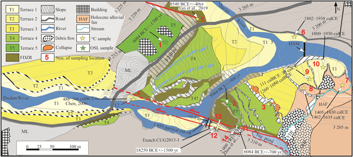
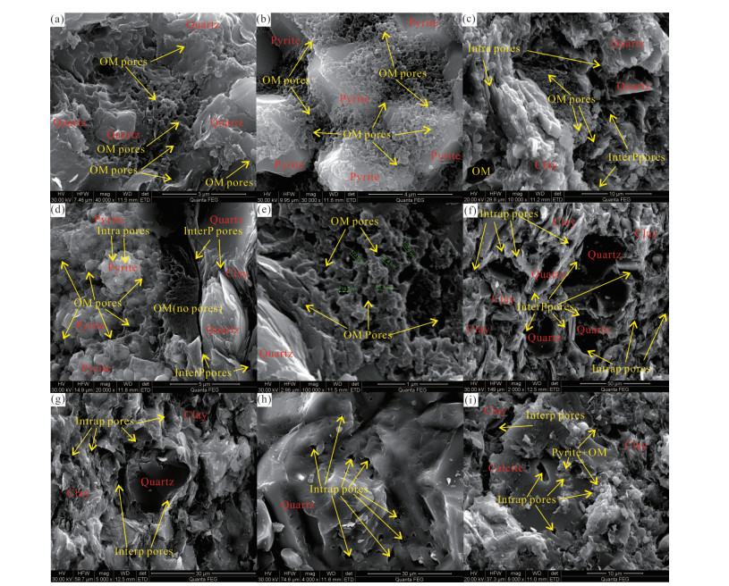
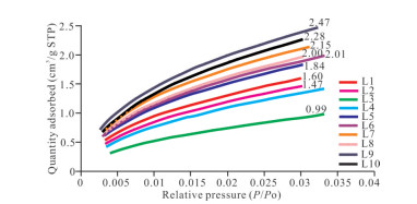
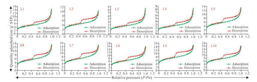
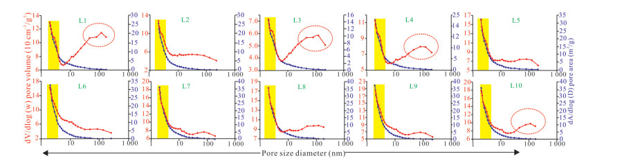
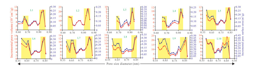
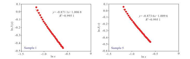
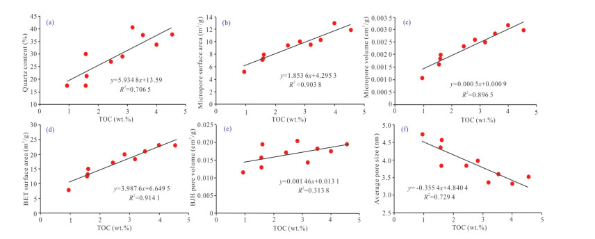
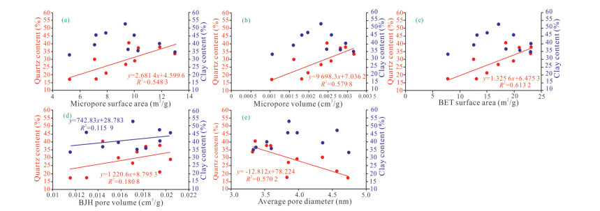
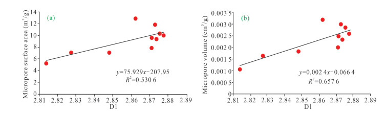
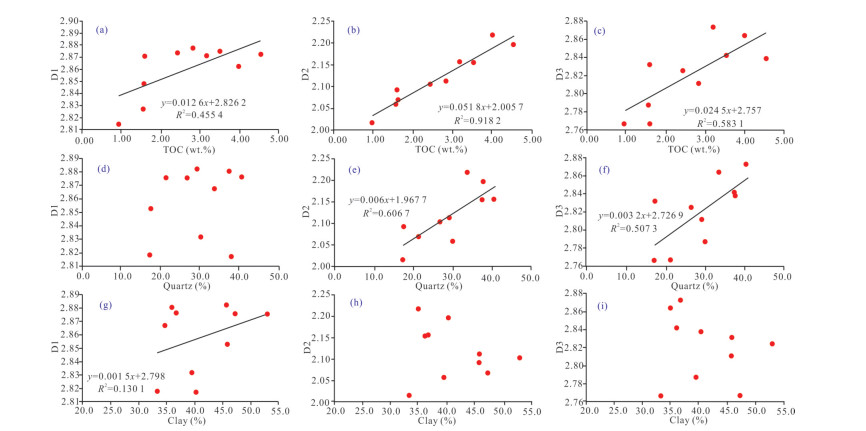
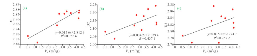
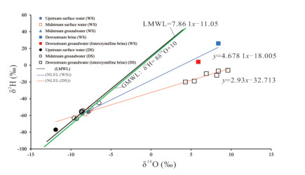
Exploration practice indicates that free gas is the key to the large-scale development of shale gas, while adsorbed gas is also of great significance to the sustainable development of shale gas, and thus systematic researches on absorbed pores are needed. To date, researches on pore structure and multi-scale fractal characteristics of absorbed pores in marine shale are obviously insufficient, limited the understanding of gas production behavior from shale reservoir. In this study, total organic carbon (TOC), X-ray diffraction (XRD), CH4 adsorption, field emission electron microscopy (FE-SEM), and low temperature gas (i.e., CO2 and N2) adsorption/desorption analyses were conducted on 10 continuously core samples from the Lower Silurian Longmaxi shale in the Fuling region of Sichuan Basin, China. The results indicate that the TOC content of marine shale samples changes from 0.95% to 4.55% with an average of 2.62%, showing an increasing trend with the increase of burial depth; moreover, quartz and clay are the dominated mineral compositions in marine shale, and they show a certain negative correlation. FE-SEM analysis indicates that almost all pore types in marine shale are related to organic matter (OM). Hysteresis loops of marine shale samples mainly belong to Type H2, further indicating that the pores in marine shale are mainly ink-bottle pores (i.e., OM pores); moreover, adsorption isotherms obtained from CO2 adsorption data all belong to type I, indicating microporous properties for all shale samples. Comprehensive analysis indicates that pore volume and pore surface area of adsorbed pores (< 300 nm) is mainly provided by the pores within the pore range of 0.6–0.7, 0.80–0.85, and 1.7–5.0 nm. Based on the micropore filling model and the Frenkel-Halsey-Hill (FHH) model, multi-scale fractal dimensions (D1, D2, and D3) are calculated from gas adsorption data (i.e., CO2 and N2), corresponding to part of micropore (0.6–1.1 nm), small-mesopore (1.7–5.0 nm), big-mespore and part of macropore (5.0–300 nm), respectively. Relationships between shale compositions, pore structure, and fractal dimensions (D1, D2, and D3) indicate that pore structure and multi-scale fractal characteristics of absorbed pores in marine shale are obviously influenced by the contents of TOC and quartz, while clay minerals have little effect on them. Comprehensive analysis indicates that the complexity of marine shale pores within the range of 0.6–1.1 and 1.7–5.0 nm has significant effects on CH4 adsorbability, while the larger pores (5.0–300 nm) almost have no effect.

Hydrologic Time Scale: A Fundamental Stream Characteristic
Robert E. Criss
2022, 33(5): 1291-1297. doi: 10.1007/s12583-022-1655-8
Abstract:

A new, fundamental catchment attribute called the hydrologic time scale τ governs the rate of delivery of runoff to a particular site, and is equal to $ \int {Q} dt/ \int|{d} {Q}|$, where Q is discharge and t is time. The value of τ for any gauged site is readily calculated from tabulated discharge data by replacing the integrals with sums. This quantity, coupled with the square root of catchment area, $ \sqrt{\mathit{A}} $, form a coordinate pair that embodies the characteristic time and length scales for any catchment, which govern its flow dynamics. The fitting constants used in several unit hydrograph models are simple multiples of τ, so knowledge of τ allows rapid calibration of these models for the particular site, facilitating flow prediction from rainfall data. Values of τ reflect many different landscape attributes, but for multiple sub-basins in watersheds with homogeneous land use and lithologic conditions, they correlate linearly with $ \sqrt{\mathit{A}} $. The ratio $ \sqrt{\mathit{A}}/\mathit{\tau } $ provides a characteristic velocity that is high for channelized, flood-prone rivers, for flashy urban streams with high impervious cover, and for sites downstream of hydropower dams. Sites with low velocities are resistant to flooding, as their landscapes have a greater ability to delay the delivery of runoff by retention, detention, and infiltration into the groundwater system.

Seasonal Interaction of River Water-Groundwater-Salt Lake Brine and Its Influence on Water-Salt Balance in the Nalenggele River Catchment in Qaidam Basin, NW China
Jibin Han, Jianxin Xu, Lei Yi, Zheng Chang, Jianping Wang, Haizhou Ma, Baoyun Zhang, Hongchen Jiang
2022, 33(5): 1298-1308. doi: 10.1007/s12583-022-1731-0
Abstract:

Identifying interactions among river water, groundwater and salt lake brine is important for sustainable exploitation of brine mineral resources. In this study, we investigated the water exchange rate in dry and wet seasons, and assessed the influence of seasonal water exchange on brine concentration and crystallization process in the Nalenggele (NLGL) catchment of Qaidam Basin, China. The results show that the surface water infiltration and groundwater recharge rates in the wet season were 2.81 × 10⁻³ and 1.15 × 10⁻³ m3/(s·m) in upstream, 1.63 × 10⁻² and 1.53 × 10⁻² m3/(s·m) in midstream, and 2.83 × 10⁻⁴ and 6.82 × 10⁻⁵ m3/(s·m) in downstream, respectively; while their counterparts in the dry season were 9.81 × 10⁻⁴ and 5.05 × 10⁻⁴ m3/(s·m) in upstream, and 8.34 × 10⁻³ and 7.78 × 10⁻³ m3/(s·m) in midstream, respectively. The water exchange strongly influenced brine concentration and crystallinzation process, with brine chemistry belonging to 3K2SO4·Na2SO4 and KCl types in wet and dry seasons, respectively. The strong water exchange in wet season destroyed the water-salt balance, while the low water exchange rate in dry season facilitated preparation of KCl products.

Nitrogen Isotopes from the Neoproterozoic Liulaobei Formation, North China: Implications for Nitrogen Cycling and Eukaryotic Evolution
Ting Yang, Xinqiang Wang, Dongtao Xu, Xiaoying Shi, Yongbo Peng
2022, 33(5): 1309-1319. doi: 10.1007/s12583-020-1085-4
Abstract:

The nitrogen isotope compositions (δ15N) of sedimentary rocks can provide information about the nutrient N cycling and redox conditions that may have played important roles in biological evolution in Earth's history. Although considerable δ15N data for the Precambrian have been published, there is a large gap during the Early Neoproterozoic that restrains our understanding of the linkages among N cycling, ocean redox changes and biological evolution during this key period. Here, we report bulk δ15N and organic carbon isotope (δ13Corg) compositions as well as the total nitrogen (TN) and total organic carbon (TOC) contents from the Tonian fossiliferous Liulaobei Formation in the southern part of the North China Platform. The δ15N in the study section is dominated by very stable values centering around +4.3‰, which is moderately lower than that in modern sediments (~+6‰). These positive δ15N values were attributed to partial denitrification under low primary productivity (scenario 1) and/or denitrification coupled with dissimilatory nitrate reduction to ammonium (DNRA) (scenario 2). In either case, the availability of fixed nitrogen may have provided the nutrient N required to facilitate facilitated eukaryotic growth. Our study highlights the pivotal role of nutrient N in the evolution of eukaryotes.

Does the Mantle Contribute to Granite Petrogenesis?
Yongfei Zheng
2022, 33(5): 1320-1320. doi: 10.1007/s12583-022-1747-5
Abstract:
What are the Lacustrine Fine-Grained Gravity Flow Sedimentation Process and the Genetic Mechanism of Sweet Sections for Shale Oil?
Caineng Zou, Youliang Feng, Zhi Yang, Wenqi Jiang, Songqi Pan, Tianshu Zhang, Xiaoni Wang, Jichang Zhu, Jiarui Li
2022, 33(5): 1321-1323. doi: 10.1007/s12583-022-1746-6
Abstract:
Why Can China Realize the Continental "Shale Oil Revolution"?
Caineng Zou, Zhi Yang, Guoxin Li, Jianzhong Li, Xianyang Liu, Yong Tang, Tao Jiang, Yu Yang, Xuefeng Bai, Songqi Pan, Lu Minghui, Zhengdong Lei, Bo Cai
2022, 33(5): 1324-1327. doi: 10.1007/s12583-022-1745-7
Abstract:
What is the Future Road for Mineral Exploration in the 21st Century?
Huayong Chen, Junling Zhang
2022, 33(5): 1328-1329. doi: 10.1007/s12583-022-1744-8
Abstract:
Can Modern Science Answer the Great Questions?
Robert E. Criss, Anne M. Hofmeister
2022, 33(5): 1330-1332. doi: 10.1007/s12583-022-1743-9
Abstract:
Has Axial Spin Decline Affected Earth's Geologic and Tectonic History?
Anne M. Hofmeister, Robert E. Criss, Timothy M. Kusky
2022, 33(5): 1333-1336. doi: 10.1007/s12583-022-1748-4
Abstract:
Will there be Unexpected Geological Discoveries?
Roger Mason, Zhenbing She
2022, 33(5): 1337-1337. doi: 10.1007/s12583-022-1742-x
Abstract:
How Can Earth Science Help Reduce the Adverse Effects of Climate Change?
Frits Agterberg
2022, 33(5): 1338-1338. doi: 10.1007/s12583-022-1741-y
Abstract: